|
June 19, 2005: Palm Springs Trip Day 2 |
|
Return to Main Index for Palm Springs Pictures |
At Greg's House
 |
 |
 |
 |
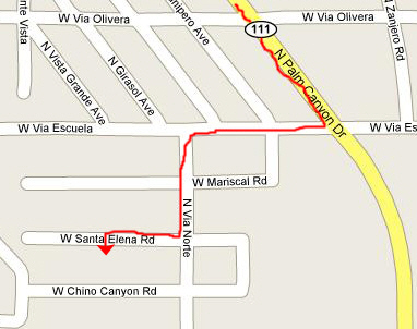 |
It's easy to find his house, since it is just a block west of the main highway and two blocks south of one of the major cross streets. We found his house on West Santa Elena Road with no problem. He stayed up late to greet us and show us to one of the casitas by the pool (more about his house later). Then, since we were pretty beat from the trip and the drive, we turned in.
|
|
Greg seems to have settled in to Palm Springs (he's been here about six months now) very well. He's got everything moved in and has quite gotten in the swing of parties and activities. He has even acquired the services of a houseman, Mike who, apparently, does some cooking and cleaning for a half day four or five times a week. We never did quite figure out how Greg had run into him, or what possessed Greg to hire him (so far as I know, Greg has never seen fit to have household help before), but he was a very good cook and not hard to look at, so I guess that answers that question.
|
|
The Tahquitz Falls Hike
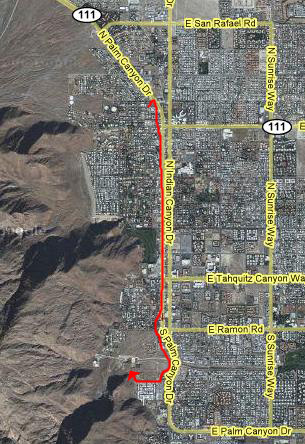
Before leaving for Palm Springs, Fred and I had done a fair amount of research on the Internet regarding the various hikes and waterfalls that we might want to do and see while we are here visiting Greg. There were quite a few interesting options that we found, and we didn't want to waste any time getting to take advantage of them. So, with Greg and Will and Brad content to spend the afternoon around Greg's pool, Fred and I went off to do the first of the hikes we'd read about- the hike to the waterfall in Tahquitz Canyon.
 |
 |
Centuries ago, ancestors of the Agua Caliente Cahuilla (pronounced Kaw-we-ah) Indians settled in the Palm Springs area and developed extensive and complex communities in Palm, Murray, Andreas, Tahquitz and Chino Canyons. Abundant water and hundreds of plants (including palm trees) and animals found throughout the area ensured stable living conditions. Crops of melons, squash, beans and corn were grown, animals were hunted, and plants and seeds were gathered for food, medicines, basketweaving etc. Many traces of these communities exist in the canyons today, including rock art, house pits and foundations, irrigation ditches, dams, reservoirs, trails, and food processing areas.
In recent years, particularly during the "hippie period" in the late 1960s, non-Indians misused the ancient tribal lands by camping indiscriminately, fouling the landscape and the water courses and ignoring sacred Indian traditions. The result has been that the Agua Caliente have had to restrict access to some sites, enforcing the land claims granted them by the US Government. Tahquitz Canyon was one of those most affected, and for many years, access to the waterfall was by guided tour only. Just recently, a new Visitor Center has been built offering guided tours as well as individually-guided walks. Access to the lands used to be free, but now there is a charge for Tahquitz Canyon and the other major canyons on Agua Caliente lands.
 |
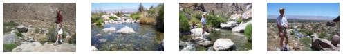
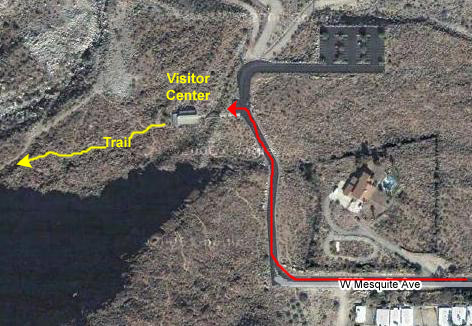
In the Visitor Center, we paid our fees, watched a short movie, put on our little blue plastic bracelets that meant we'd paid our fee, and headed out the back of the building. The hike began right outside the building where the small stream that flows down from the waterfall comes right by the building itself. Fred stopped to take a picture of the little stream and the trail ahead. Then we crossed a wood footbridge and started up the trail.
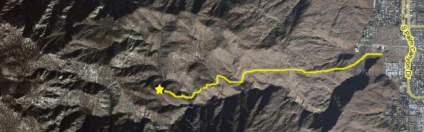
The hike up to the Tahquitz Canyon Waterfall was an interesting one, made more pleasant by the fact that we were usually right alongside the stream coming down out of the canyon. We took a lot of pictures along the way, and I've included thumbnails for the best of them below. To view the full-size image, of course, just click on the thumbnail for it.
|
|
|
|
|
|
|
The last water feature that we encountered before arriving at the falls was this small waterfall, which came from an upper pool that had formed in the stream. There was some sort of measurement device in that pool, probably to keep track of the flow level in the stream. In any event, we paused beside this small waterfall to enjoy its sound and motion. You can, too, if you watch my movie with the player at right.
 |
|
|
|
|
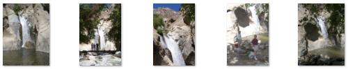
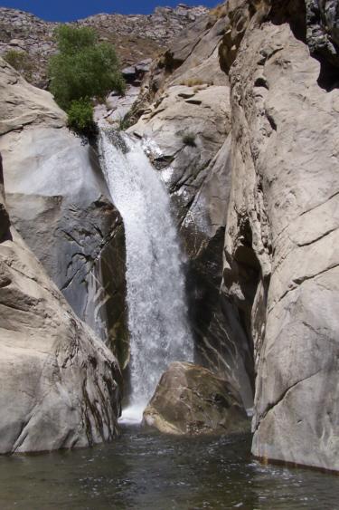
The Tahquitz Canyon Falls were not the highest we'd ever seen, by far, nor did they have a great volume of water flowing over them. I guess what made them so special is that they were so totally unexpected (well, I mean we knew they were there and all)- I mean totally unexpected for the desert terrain of Palm Springs. We expect waterfalls and streams in mountainous areas that get a fair amount of rainfall, or might have melting snow, but it is already pushing a hundred degrees in Palm Springs at this time of year, and it seems as if waterfalls and streams would be the last things you'd find. But that is part of the beauty of Palm Springs. Although it is hot and dry in the valley, the San Jacinto mountains right behind the city offer a stark contrast, providing water flows like this in the spring and into the middle of the summer. Even in the late summer, though, there is plenty of water underneath the valley, which is why there are so many artificial lakes and ponds throughout the city, and why so many fountains and other water features are routinely constructed.
The falls offered a quiet beauty, dropping off a sheer rock precipice in an unbroken 100-foot drop. The fallen boulder at the bottom added additional interest to the falls, as the water flows over and then forms a pool at its base. The pool was wading depth except right at the base of the falls where it was four or five feet deep. About half of the pool was shaded by some large trees, and a rock morraine (natural or artificial I couldn't tell) formed a porous dam that kept the pool full before the overflow left the pool to form the stream that we'd followed on the way up.
We took many more pictures of Tahquitz Canyon Falls than I want to include here, but below are thumbnails for some of the best ones. Take a look at the full-size images by clicking on the thumbnails:
|
As usual, I wanted to do some more climbing around the falls; I was actually hoping that I could find a way up to the top of the falls so I could get some views looking down into the pool. To the left of the pool, there was a crevasse where the rock face was not sheer, and where you could indeed climb up, and so off I went. I had gotten most of the way up when Fred snapped this picture where, if you look carefully, you can see me in the center of the picture. As I got higher, it became apparent that there was no easy way to work myself around to the top of the falls themselves, so I had to content myself with the view I could get from where I was. And they were spectacular, particularly this view out into the Coachella Valley. I could also look down on the Tahquitz Falls pool in the trees below and, with my zoom, I could get a picture of Fred waving up at me.
I climbed back down to the pool to find that some other hikers had arrived and had gone wading in the pool. One of them pointed out the flecks of pyrite (at least we assumed it wasn't really gold) that littered the bottom of the clear water, and so I went wading to see if I could find some.
We stayed at the pool for quite a while, just enjoying the view and the natural air-conditioning. Eventually, the other hikers left to return down the trail and we were left by ourselves. It was a perfect time to capture one more picture of Fred at Tahquitz Canyon Falls.
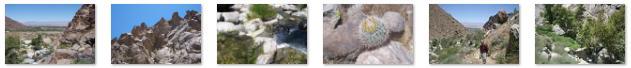
The trail back led us in a different direction; it was nice that we didn't just retrace our path so that we could see something new. From the pool, the trail ascended a ways up the canyon wall to the left of the falls, and reached a natural rock overlook that afforded a really great view back down the canyon and out into the valley. From here, the trail ran around the canyon wall, with the valley almost always in view. We could look down on the stream and out to the valley- all very pretty. Just before descending back down to the level of the stream, we found a huge flat tablerock right beside the trail. We climbed up on it to see what the view from the table rock was like, and it was a great one.
There were a lot of amazing views along the trail back to the Visitor Center, and I've included the best of them here in this album. To view the full-size pictures, just click on the thumbnails below:
|
When we got back to the Visitor Center, we looked at some more of the exhibits, and got some information about some of the other hikes on Indian lands here in the valley and nearby- information that we would use in planning some more outings. Then we headed back to Greg's house for a dip in the pool and some lunch.
The Araby Trail (Bob Hope House)
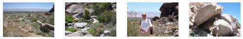
Saturday afternoon, Fred and I went on a shopping trip to buy some things for the two casitas at Greg's house. In the nature of a housewarming gift, we wanted to outfit both casitas with all the things that a visitor might require- cosmetics, hair dryers, bath accessories and the like. We found a Target a ways down Palm Canyon and we spent some time there getting everything together.
I also took Fred by the Cheesecake Factory that Greg and I had visited last November when I was out here touring homes with he and his Realtor; I wanted Fred to see the architecture. As we were driving along Palm Canyon, Fred pointed out Bob Hope's uniquely-designed home perched on one of the low hills between Palm Canyon and the San Jacinto mountains. So before we went on back to Greg's, we thought we'd try to drive up to the home to look at it.
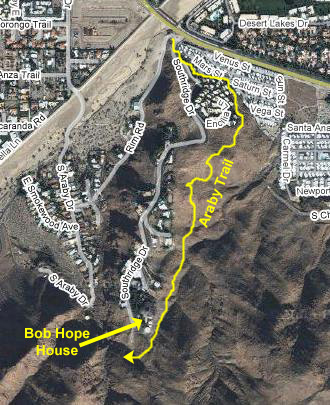 |
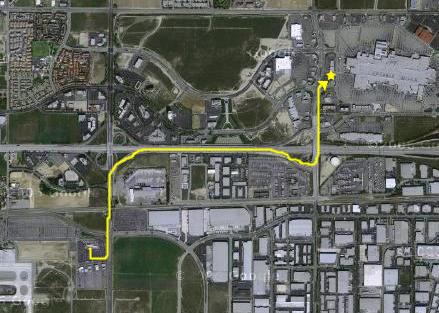
We parked the car down at the foot of Southridge Road, and then followed the marked trail along an area of trailer homes, below an apartment complex, and then up into the hills, generally following the route shown at the left.
 |
With some help from Fred, I tried to describe the Hope house in a movie, and you can watch that movie using the player below:
|
|
To get back to the car, it seemed logical that we simply walk down Southridge Road, instead of following the trail back. It was getting dark, and hiking would have been an iffy proposition. Besides, if the guard gate was actually occupied, they would be unlikely to stop someone walking OUT the gate. So that's what we did, reaching the car in just about fifteen minutes. Then it was back to Greg's and then out to dinner with him and Brad and Will.
You can use the links below to continue to another photo album page.
|
June 19, 2005: Palm Springs Trip Day 2 |
|
Return to Main Index for Palm Springs Pictures |