|
June 20, 2005: Palm Springs Trip Day 3 |
|
June 18, 2005: Palm Springs Trip Day 1 |
|
Return to Main Index for Palm Springs Pictures |
Bear Creek Canyon Hike
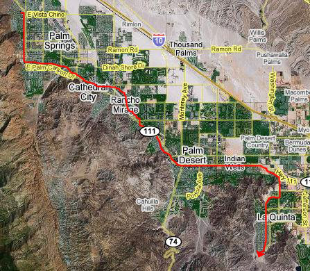 |
We left Greg's house before everyone was up- a little before eight in the morning. Getting to the trailhead was straightforward, but time consuming. Essentially, it is again a straight drive down Palm Canyon Drive (Highway 111). We passed through downtown Palm Springs, and then Cathedral City and Rancho Mirage. Although the highway is wide, it is all built up along its route, so there were a fair number of lights but not much traffic this early on a Sunday morning.
We did get to see most of the valley cities, though, going through Palm Desert and Indian Wells before finally ending up in La Quinta. Palm Springs is the oldest city in the valley; the development has moved continually southeast along the mountains. La Quinta is about 30 miles from Greg's house.
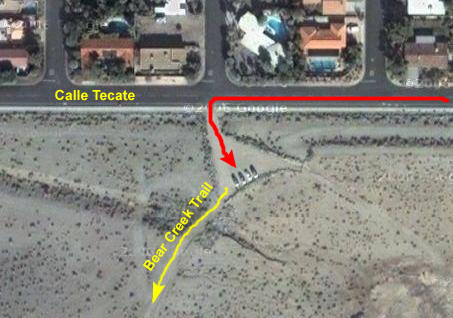 |
From the parking area, we found that there was a wide, well-marked trail that led off to the actual trailhead. Before we started off, I thought we should take a couple of pictures (if only to compare our fresh condition now to what I thought would be our exhausted condition when we returned in the afternoon. Fred's picture of me looks from the parking area southeast to one of the ridgelines in the San Jacinto mountain range. I looked the other way to show Fred on the path to the trailhead.
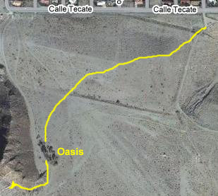 |
Near the parking area, the City of La Quinta has built a real nice hiking park in the area called "Oasis Cove", and the trail leads to that oasis. As it turned out there WAS a water fountain at the oasis, so that was good.
Once we got to the oasis, the trail guide told us to keep walking past the "oasis" about 100 yards. There is a wash to the right; the guidebook told us to climb down into the wash (a dry riverbed) and then turn south. This we did.
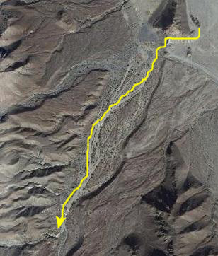 |
As we walked along, the canyon and the wash narrowed somewhat. Our guidebook said that the walk through the wash to the trailhead would take about 20 minutes, and we should look for a small canyon to the right that "has black charred rock from camper's use." This would be our landmark, for not far past this canyon, "at the Palo Verde tree," (I hope the tree is here permanently) is the trail head that marks the beginning of Bear Creek Ridge Trail.
The guidebook said that there would be a sign identifying the beginning of the Bear Ridge Trail. There WAS a sign, and that was the good news. But, unfortunately, there was another sign, too.
I suppose that we could have ignored the sign and continued on the trail. After all, it was only eleven days before the end date of the requested non-use period. And the sign didn't really say that using the trail now was forbidden, but that avoiding the use of the trail was "requested." So we were in something of a quandary as to what to do.
I guess the deciding factor was that, once we got here to the trailhead, and could actually see the trail up into the hills, it was apparent that it would be a pretty barren hike- at least as far as we could see. Sure, there might be good views of the valley, but we weren't sure that they would justify a long, hot uphill climb.
In the end, we decided to turn back, and save this hike for a future trip out here, perhaps doing the hike in the fall or early winter. So, maybe just a bit reluctantly, we turned around to walk the half-hour back to the oasis.
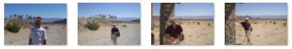
When we got to the oasis, we each took a couple of pictures in and around it; I've put thumbnails for them below, and you can look at the full-size images by clicking on them:
|
The Museum Trail Hike
 |
To make the hike more interesting, we decided to stop at a local Subway to pick up a sandwich to take with us, and we planned on stopping somewhere up the trail to have that lunch. We wouldn't go very far today, though, not nearly as far as I went last time I was here in Palm Springs.
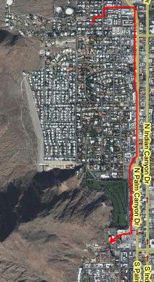
Although we drove directly to the Palm Springs Desert Museum, at the corner of whose parking lot the trail begins, I wanted to show you where, relative to Greg's house, the museum and the hike were. In the hybrid map at the left, you can see that downtown Palm Springs, and hence the museum, are really very close to Greg; you could actually walk from his house to the museum in a half hour or so. I guess that is one reason why he picked the house he did.
We picked up our sandwich at a Subway a few miles south of the Museum on Palm Canyon, and arrived in the museum parking lot about noon.
 |
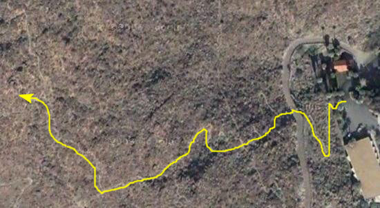
And that trail system is very, very extensive. There are hundreds of miles of trail that crisscross the mountains and lead up and down into the desert cities. From San Bernardino in the north (and the mountain town of Idyllwild that we will visit later in the week), down through the mountains behind Palm Springs, and almost to the Salton Sea, the trails extend throughout the range. The main access point anywhere near downtown Palm Springs is the trailhead at the corner of the parking lot for the museum. There, you can find a map of the trails relatively near the museum; hiking further requires some planning and a more extensive trail map.
When I was here last year, I hiked much farther than we were going to hike today. Back in November the weather was much cooler and the hiking much more pleasant. One of my hiking goals is to hike all the way to the crest of the San Jacinto mountains and then follow that crest to the Palm Springs Tramway. But today, we will stay entirely within the area I've outlined on the aerial view at the right, maybe hiking a mile or two into the mountains.
 |
Last November, I discovered that just about the only bad thing about the Museum Trail hike is that there are so many opportunities for great pictures that it's hard to resist stopping ever minute or so to take a picture of one view or another. We found the same thing to be true today, taking many pictures along the hike. Again, I've chosen only the best of them to include here, especially since you've probably already seen quite a few of them earlier in the album.
Right at the beginning, the trail ascends steeply along the hillside behind the museum, following some well-worn switchbacks. One of the nicest early views is of Oakwood Golf Course, which is right in downtown Palm Springs. The trail climbs up to a private road that goes to a house that is situated above the museum; hikers are cautioned that the homeowner has allowed hikers to cross the road but that they shouldn't walk up along it to the house itself. I guess the house is an old one for the area, and was there before the trail system became so widely used.
Once the road is crossed, the trail climbs steeply for about a half mile further until the hiker crosses the first ridge. At this point, the view of downtown Palm Springs doesn't include the museum itself, since it is right below the ridgeline. The big building is the downtown mall that is about a block from the museum. Hiking up a bit further, the expanse of south Palm Springs opens up, as in this view looking southeast.
We continued hiking for another mile or so, following the winding trail as it ascended into the hills, crossing some of the other low trails that run along the mountainside near Palm Springs. This view looks southwest along the first major range directly towards Tahquitz Canyon where we hiked yesterday. Further along in the hike, Fred noticed that he could get a good zoom view of the Bob Hope house and the Araby trail beyond and above it.
To give you a better idea of what the trail itself is like, here are a couple of pictures of each of us on the trail. First, there's one taken by Fred of me on the Museum Trail, and there's one I took of Fred. As you can see, the trail is easy to follow and at least at this low level, it has been well-traveled. The hike so far is something that just about anyone who is not handicapped could do without much problem.
 |
Now the trail begins to ascend steeply again, and after another half mile or so the views have changed again, as evidenced by this view of downtown Palm Springs and this view of west Palm Springs (the view here looks south).
From this point, the views started to get repetitive, and slow we slowed down in our picture-taking; the ones you've seen so far are representative of the others we took. From time to time, we were in small valleys and out of sight of the impressive views, but eventually as we ascended further up that first major ridge, they returned.
We hiked about 90 minutes up along the trails before we decided to stop for lunch. But then the question became "Where shall we stop?" There didn't seem to be much alternative to just sitting down by the side of the trail in the hot sun and eating our sandwiches and drinking our by this time warm drinks.
But then we came around a curve in the trail and saw the ideal place (actually the only place)- a natural rock seat with an overhang providing some shade. There wasn't much alternative as far ahead as we could see, so this was it. We shared the opportunity to sit in the partial shade and have lunch. It was actually pretty pleasant to just relax for a while.
After lunch, we only hiked another half mile or so; we'd gotten an excellent taste of this particular trail, and we may return later in the week (and later in the day, I think). We turned around and headed back the way we came to the museum, our car, and the drive back to Greg's.
We spent the afternoon at the amazing pool at Greg's house, and later on I used the small blender that Greg had (another idea for a housewarming gift) to make some frozen drinks. I believe it was this evening that we met some other friends of Greg's at a Mexican restaurant downtown for dinner. All in all, quite a nice day, even after the washout at the first hike.
You can use the links below to continue to another photo album page.
|
June 20, 2005: Palm Springs Trip Day 3 |
|
June 18, 2005: Palm Springs Trip Day 1 |
|
Return to Main Index for Palm Springs Pictures |