|
June 26, 2005: Palm Springs Trip Day 9 |
|
June 24, 2005: Palm Springs Trip Day 7 |
|
Return to Main Index for Palm Springs Pictures |
Trip to Big Bear Lake
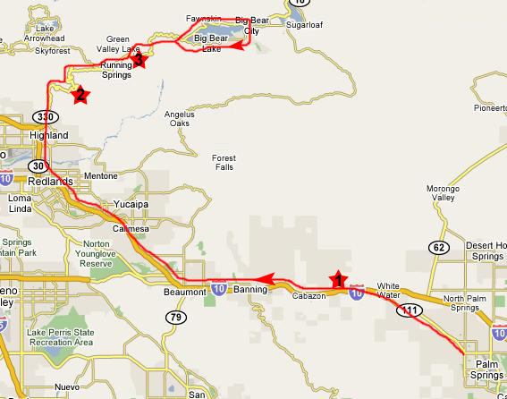 |
Truth be told, you can see the mountains in which Big Bear Lake is nestled from Palm Springs. They are far off in the distance but characterized by the snow that stays atop them until mid-summer. So we can see where we are headed, but it is something of a circuitous route to get there.
From Greg's house, we headed up Palm Canyon Drive (California 111) to the intersection with Interstate 10, and then we headed west. Shortly after getting on the Interstate, we pass through the windmill farm, the collection of hundreds of wind turbines, some large and some small, that dot the landscape and the ridgelines here (spot #1 on the map) in the pass from the desert to the coastal cities. Fred always finds these turbines interesting; he says he'd like to have one himself, but they are only cost-effective in areas with pretty constant wind, and I don't think that Downhill Run Acres qualifies.
We continued west on the expressway through Beaumont and into Redlands, which is the easternmost of the cities and towns that, together, make up the Los Angeles metropolitan area. Here, we cut north on the 30/330 expressway up through Highland and into the mountains.
|
|
|
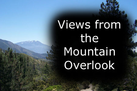
To view the slideshow, just click on the image at left and I will open the slideshow in a new window. In the slideshow, you can use the little arrows in the lower corners of each image to move from one to the next, and the index numbers in the upper left of each image will tell you where you are in the series. When you are finished looking at the pictures, just close the popup window.
|
|
Leaving the overlook, we were off on our last driving leg to Big Bear Lake. The mountain road, while somewhat winding, was a pleasure to ride, and this movie may give you some better idea of what it was like driving the mountain road; watch it with the player below:
|
|
 |
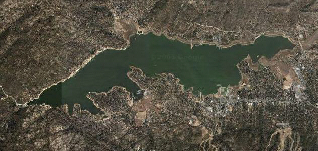 |
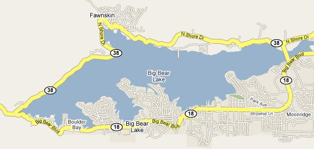
I thought you might want to see what the aerial view of the lake looked like, so I tried to capture an aerial view that just matches the scope of the map view. Of course, the maps on the Internet are somewhat "stylized" so that it is easier to show actual roads and highways, so you'll note that the two views are slightly different. But they are similar enough that I think you'll be able to easily match up the features on both.
Our plan is to drive completely around the lake, first following California 38 on the north side of the lake going west to east, then crossing the end of the lake to link up with California 18 in Moonridge, to follow that back west. While it is possible to get back to Palm Springs by continuing east on California 38, Greg tells us it is a long, winding road that is mostly through the desert, and that it typically takes much longer for the trip that way. Another consideration was lunch, and we planned to have that somewhere in Moonridge.
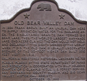
As soon as we reached the lake, we found ourselves at the dam that holds back the water in the lake, and so we stopped there to wander around and take some pictures.
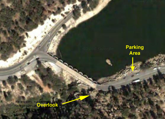 |
To stop at the dam, we had to go a hundred feet or so along the south shore of the lake to park just above a spot right at the end of the lake. From our parking spot, here is a view looking towards the dam. There were some folks here fishing, and as we walked towards the dam, we could see them as we looked east across Big Bear Lake.
When we reached the dam itself, we just had to cross the road at which point we could climb up on the rocks and look down into the canyon below the dam. From this vantage point, here is a good picture of the Big Bear Dam.
|
|
When we'd seen all there was to see at the Dam, we headed off on our circle around the lake. At the deep end of the lake, near the dam, there were lots of boaters and fishermen taking advantage of the deep water. From our vantage point where we parked, we could also get an excellent view of Big Bear Lake itself and the mountains in the background. Here are Greg and I at the parking area just before we headed off around the lake.
Our trip around the lake was very scenic. One of best views was taken along the north shore of the lake, when the road curved around so that we could actually look back to the northeast, and we could see the Sierras near Big Bear Lake. Big Bear Lake is a popular vacation spot, and also a spot where many well-off people have summer homes and cabins which look as if they have all the amenities- heaven knows we can't be far from cable or satellite! We stopped in Moonridge and ate lunch at a local diner-type place, and then continued around the south end of Big Bear Lake and back to the dam. This is a neat place, and it would be nice to come spend a few days here in the summertime. Had I been writing this narrative in real time, I would probably say something to the effect that if Greg stays in Palm Springs long enough, we might come back out for another visit and do exactly that. But I am writing this narrative almost two years later, and can report that Greg will NOT be in Palm Springs that long, and so Big Bear Lake will probably remain one of those places we don't return to.
|
|
It was a beautiful day trip, and we planned to get back to Greg's house in time for Fred and I to do one more hike up above downtown Palm Springs.
Museum Trail Hike
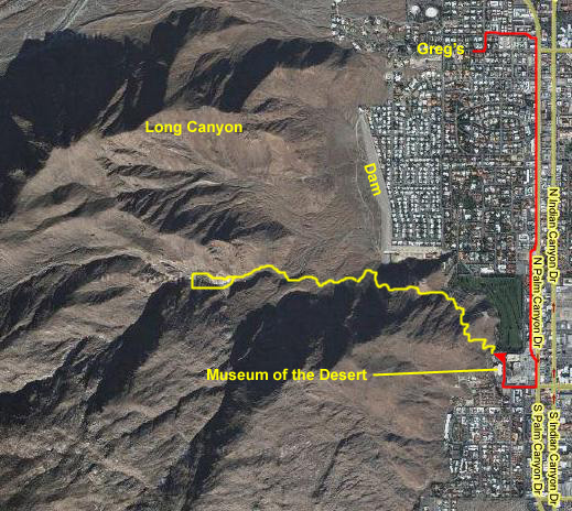 |
On the aerial view here, I've once again indicated where the Museum Trail is in relation to Greg's house. Although it's impossible to be precise, I've also indicated the approximate route we followed up into the hills. And I've also pointed out some of the major features that will show up in the pictures and movies- including Long Valley, Palm Springs, of course, and the Long Valley Dam (which is only there to deflect the once in a while flash flood that can occur).
We reached the Museum about four in the afternoon, and before hiking up the trail, we walked through the sculpture garden across the street from the museum itself. Then we went to the corner of the parking lot where the trailhead is, and started up the trail itself. Just a very short way up the trail, Fred took this picture of a house located at the south end of the course near the museum. To give you an idea of how the trail ascends, he took another picture of the house when the trail reached and crossed the private drive I mentioned in our earlier hike.
As we got higher, of course, the views got better and better. Here is a picture Fred took of me and North Palm Springs. We were on the same trail as on our third day, and pretty soon we passed the rock overhang where we had stopped to have our lunch that day. Now, with the sun in the west, there is no shade, but the afternoon is very pleasant and very warm and the shade really isn't needed.
|
In the slideshow, the first group of pictures were taken during the first part of the hike, as we ascended to the ridgeline. They are views north, east and south over Palm Springs. The second group of pictures were taken during the second part of our hike, as we trekked along the ridgeline that we've just reached.
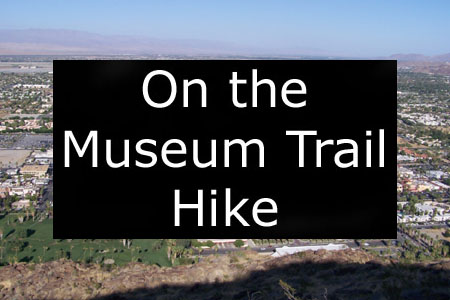
To view the slideshow, just click on the image at right and I will open the slideshow in a new window. In the slideshow, you can use the little arrows in the lower corners of each image to move from one to the next, and the index numbers in the upper left of each image will tell you where you are in the series. When you are finished looking at the pictures, just close the popup window.
After about an hour and a half, we were reaching the top of the ridgeline. While we could have continued hiking for many miles, that wouldn't have been advisable in the deepening twilight- too much chance of slipping or encountering the wildlife that comes out at night. Just at the crest of the ridgeline, we came to a trail junction. I was getting thirsty, and wondering where the nearest water was. We took quite a few really good pictures from our vantage point. Here, the San Jacinto Mountains cast their evening shadows over Palm Springs, and here we can see most of Long Valley and the earthen dam that protects North Palm Springs from flash floods. Looking west, much of downtown Palm Springs is hidden by the lower ridgelines we have crossed, but you can still see Palm Springs Airport and across the Coachella Valley. While I was taking that picture, Fred was using his 10x zoom lens to look at the airport terminal building, where we will be leaving tomorrow at noon.
To finish off our hike, Fred climbed up further along the ridgeline to get a picture of me and North Palm Springs and, at the same time, I took a picture of Fred higher up on the ridge. Our last views were a couple of movies that I think you'll like. Both pan across the city of Palm Springs from our perch high in the hills. You can take a look at Fred's movie using the left-hand player below and you can watch my movie using the right-hand player below:
|
|
You can use the links below to continue to another photo album page.
|
June 26, 2005: Palm Springs Trip Day 9 |
|
June 24, 2005: Palm Springs Trip Day 7 |
|
Return to Main Index for Palm Springs Pictures |