

|
November 6, 2005: Hawaii Trip Day 2 |
|
Return to Main Index for Hawaii Pictures |
Arrival in Honolulu
Well, we left Dallas on Saturday morning, November 5, at about ten in the morning on a non-stop American Airlines flight to Honolulu. We arrived there about two in the afternoon, local time. Since Honolulu is 4 hours earlier than Dallas, this meant that the flight took about eight hours elapsed time. But we had plenty to read, and I had my computer with me, so the flight went fairly quickly.
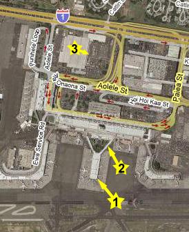 |
We continued down the sky bridge and through the concourse to the area where the rental car shuttles were, hopped on the Dollar shuttle and in a few minutes were at the rental car counter (3) out in the parking area. Ron and Jay were waiting for us there, so that's when we knew their flight had been on time. We picked up the rental car and, recalling directions to Waikiki from the last time I was here about eighteen years ago, headed off towards town. We stopped at the Ala Moana Center on the way so Ron could pick up some things he needed. I was pretty amazed that things looked so familiar.
 |
We arrived at the hotel without incident and within a few minutes we were checking in.
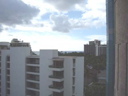
The Ohana Islander Hotel
 |
 |
We checked into our rooms and made plans to meet in the lobby in about an hour. We were going to try to get some sightseeing done this afternoon- I have suggested that we try the Cemetery of the Pacific, usually known as The Punchbowl.
 |
|
|
|
|
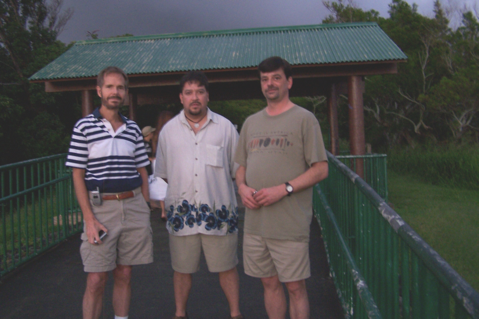
Down in the lobby, Fred got a rather unflattering picture of Ron Mathis and I in the hotel lobby waiting for Jay. He arrived in due course, we collected the car and headed off to The Punchbowl.
The Punchbowl
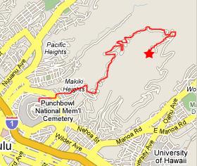
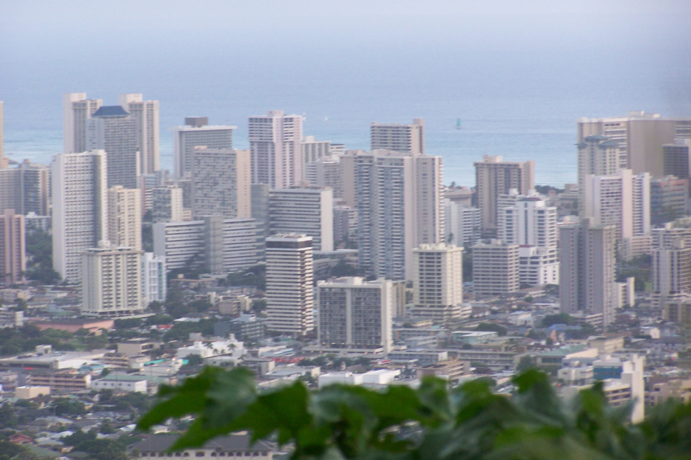
We drove around quite a bit in Hawaii, both on Oahu and on the Big Island. It is easy for non-natives to get lost when helpful folks give them directions using north, east, south and west. These directions are not readily apparent in the islands- except in the morning and the afternoon. But even then, the compass directions don't line up with the way roads run or cities have grown. So, for a long time, the natives have used some readily apparent landmarks to use as directions. In Honolulu, where the vast majority of Hawaiians live, the landmarks are Diamond Head, the ocean, the mountains and Pearl Harbor/Ewa.
For example, if you are in Waikiki and are told to go six blocks "Diamond Head," all you have to do is look around, find Diamond Head (which is easily visible from most places) and head six blocks in that direction. That you are going six blocks SSE is a distinction that matters little. Similarly, "Ewa" is the opposite direction from Diamond Head, and it can be easily found by locating the shoreline of the ocean, and facing so that the ocean is on your left. Finally, "mauka" means towards the mountains (which are always visible) and "makai" is towards the ocean (which is also always visible).
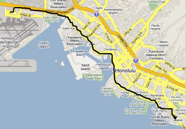
For us to get to the Punchbowl from the hotel, we have to travel "Ewa" for about four miles on Interstate H-1 (yes, Hawaii has Interstate highways, but numbering scheme is entirely different here). Before we got to the expressway, we ran into and out of a rainshower, and then, ahead in the mist, Fred found an interesting picture of this rainbow over Honolulu.
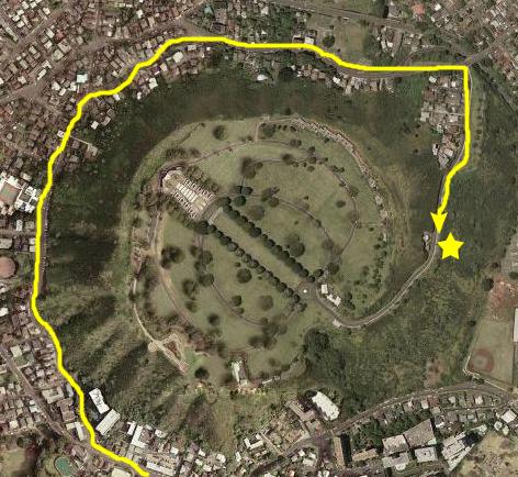 |
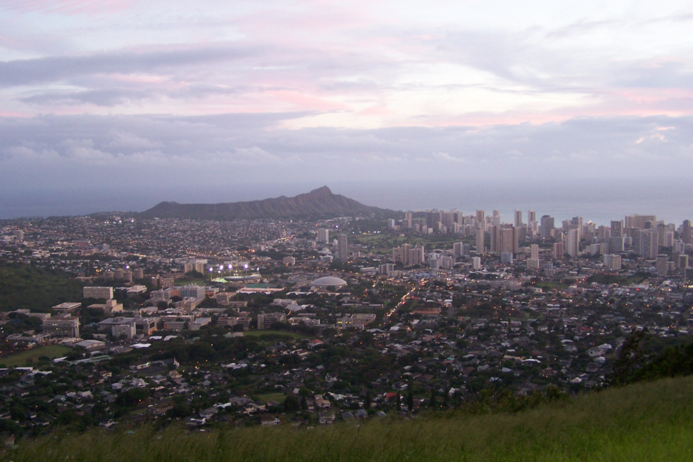
As you look at the various pictures, refer back to the aerial view and you will be able to pick out where in the Memorial we were. From the aerial view, you can see clearly why the Memorial is known as The Punchbowl- it is actually the inside of an ancient volcano crater that must have collapsed long ago. This fact is not very evident from the ground; one thinks of this area as just a fairly circular valley, losing sight of the fact that on the trip up one has to circle almost completely around a wall of hills, and then climb up and over that wall to descend into the Memorial.
 |
Prior to the opening of the cemetery, the remains of soldiers from locations around the Pacific Theater� including Guam, Wake Island, and Japanese POW camps� were rought here for final interment. The first interment was made January 4, 1949. The cemetery opened to the public on July 19, 1949, with services for five war dead: an unknown serviceman, two Marines, an Army lieutenant and one civilian� noted war correspondent Ernie Pyle. Initially, the graves at National Memorial Cemetery of the Pacific were marked with white wooden crosses and Stars of David� like the American cemeteries abroad. Eventually, over 13,000 soldiers and sailors who died during World War II would be laid to rest in the Punchbowl. Despite the Army's extensive efforts to inform the public that the star- and cross-shaped grave markers were only temporary, an outcry arose in 1951 when permanent flat granite markers replaced them.
The National Memorial Cemetery of the Pacific contains a memorial pathway that is lined with a variety of memorials that honor America's veterans from various organizations. As of 2005, there were 63 such memorials throughout the National Memorial Cemetery of the Pacific� most commemorating soldiers of 20th-century wars, including those killed at Pearl Harbor.
When we drove into the Memorial, we found that we were just about the only people here- probably because it was so late in the day and it had been raining. We parked on the main avenue that points towards the Memorial itself. You should be able to pick out exactly where we were on the aerial photograph. On either side, for as far as you can see, are the simple grave markers. There are only the occasional trees to break the view. Ahead of us is the Memorial, which in this view looks as if there is going to be or just has been some event (with the temporary canopy and chairs set up).
|
|
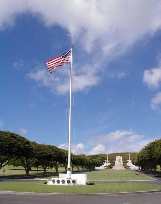
To get up to the memorial, we climbed the broad steps that lead up to the plaza in front of the Memorial itself.
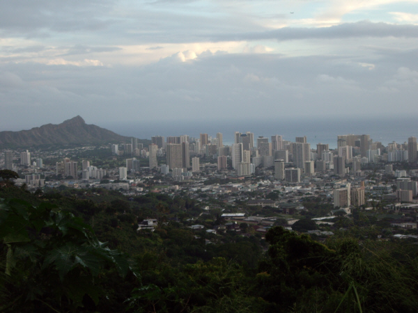
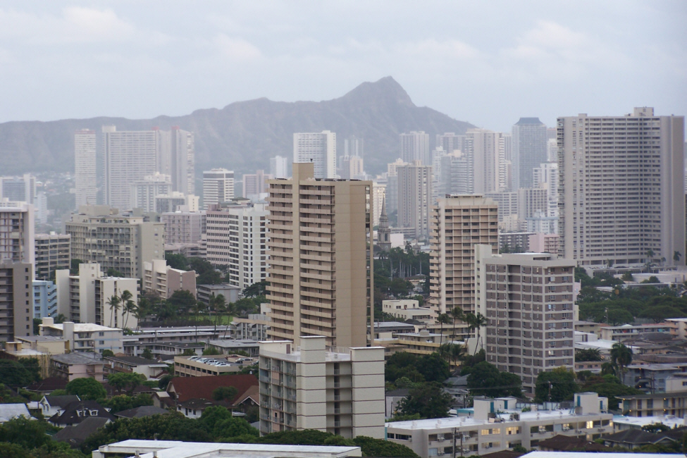
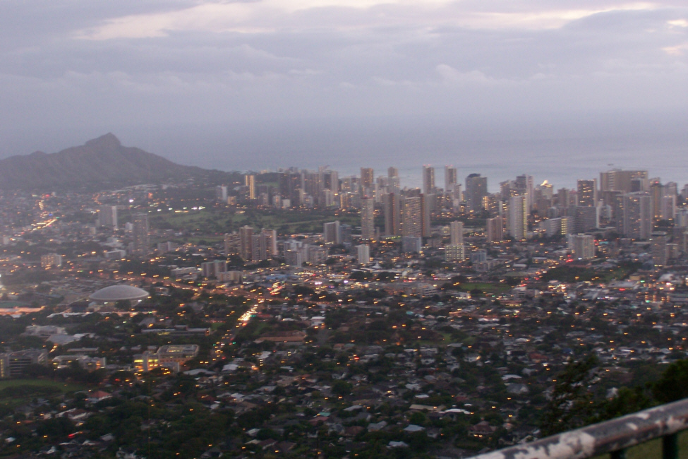
On the front of the tower which houses the chapel is a 30-foot female figure known as "Columbia" standing on the symbolized prow of a US Navy carrier with a laurel branch in her left hand and the inscription by President Lincoln "...the Solemn Pride that must be yours to have laid so costly a sacrifice upon the altar of freedom". Lady Columbia symbolizes all grieving mothers and looks out on the cemetery that fills the 116-acre Punchbowl Crater. The view from the Punchbowl encompasses the city of Honolulu from Waikiki and Diamond Head to Pearl Harbor.
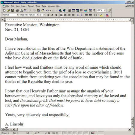 |
Executive Mansion, Washington
Nov. 21, 1864
Dear Madam,
I have been shown in the files of the War Department a statement of the Adjutant General of Massachusetts that you are the mother of five sons who have died gloriously on the field of battle.
I feel how weak and fruitless must be any word of mine which should attempt to beguile you from the grief of a loss so overwhelming. But I cannot refrain from tendering you the consolation that may be found in the thanks of the Republic they died to save.
I pray that our Heavenly Father may assuage the anguish of your bereavement, and leave you only the cherished memory of the loved and lost, and the solemn pride that must be yours to have laid so costly a sacrifice upon the altar of freedom.
Yours, very sincerely and respectfully,
A. Lincoln
Mrs. Bixby was a Confederate sympathizer, and destroyed the letter shortly after receiving it. It was also later discovered that only two of her five sons, Charles and Oliver Bixby, had died in battle. Of the other sons, one deserted, one was discharged honorably and the third either deserted or died as a POW, according to Abraham Lincoln Online. Some scholars today believe that the letter was actually written by Lincoln's secretary John Hay.
Inside the chapel and on the gates outside Fred found these glass inlays of all different colors inset into the wrought iron gates. After we took a look at the chapel and the maps, we gathered outside for a group picture on the plaza outside. We then headed back to the car and, as we left, Fred captured the row of beautiful overhanging trees with the Memorial in the background.
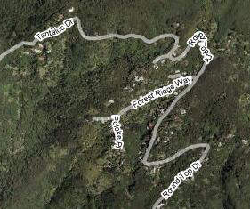
The Puu Ualakaa Overlook
 |
 |
 |
|
|
|
|
|
|
|
|
It was now too dark for more pictures, so we got back in the car and continued along the circular mountain road and back down to Honolulu. Following my nose again, I got us back to the hotel about seven-thirty (after a stop at a Wal-Mart Supercenter for some supplies). We had dinner at a Chinese buffet that we ran across when we went out looking around later. It was not one of our best dining choices on the trip, but it was OK.
Waikiki at Night
 |
The big difference was that many of the older buildings had been torn down and rebuilt as newer, fancier structures, and there were even more restaurants and shops than there had been before. The International Market was still there, but I remember the older one as being busier and with merchandise that was better quality.
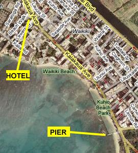
We walked all the way down almost to the beginning of Kapiolani Park to the Kuhio Beach Pier- which juts out into the ocean only a short ways. From out on this pier, I took a movie of Waikiki at night that you can watch with the movie player below:
|
|
You can use the links below to continue to another photo album page.
|
November 6, 2005: Hawaii Trip Day 2 |
|
Return to Main Index for Hawaii Pictures |