

|
November 10, 2005: Hawaii Trip Day 6 |
|
Return to Main Index for Hawaii Pictures |
Waikiki Gateway Hotel
 |
 |
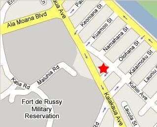
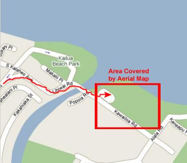
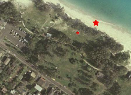
This may be overkill, but you might want to see where our new hotel is. Actually, it is only four blocks from the one where we were three days ago, but it is a little more convenient for what we want to do today. Compare the map to the aerial view and you'll be able to see right where we are, and you'll also be able to find some of the nearby buildings in the pictures that we took below.
 |
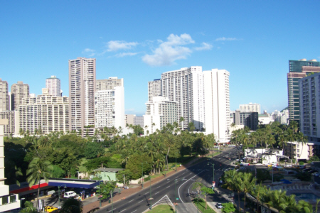 |
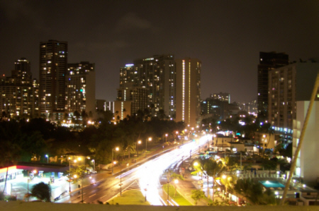
We've gotten up early so that we can do as much as possible today before Ron and Jay have to leave and before we have to leave about four hours later. While we are packing up and getting ready to check out, we've gone out to one of our balconies (we had two of them) to take some pictures of downtown Honolulu. The balcony from which we took this last shot and the one at left was at the west end of the room; there was also a balcony on the north side of the room, and the rest of our pictures were taken from there.
From this second balcony, we can look west down Kuhio Avenue towards downtown and also north towards the mountains (this one taken with a zoom to show the mountainside living). We could also look northeast towards Kailua, but we really couldn't look directly east to Diamond Head.
From this same balcony, I took a movie of the area around our hotel, and you can watch this movie with the player below:
|
|
Kailua Beach Park
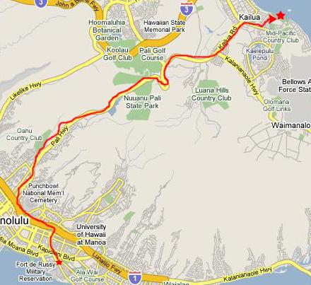 |
So we got the car out of hock and drove up to the expressway and then over to the Pali Highway, which is the closest road that takes us from Waikiki to the Kailua area. Going around by Diamond Head would have taken much longer. Once the Pali Highway leaves the developed area, it is a beautiful divided highway that cuts up through lush forest, then through the Pali Highway Tunnel and then snakes down the other side of the mountains into Kailua.
Once we entered Kailua, then I just tried to follow my nose and keep heading towards the beach. Fortunately, we soon picked up signs directing us to the beach.
 |
 |
I supposed that Ron and Jay could have gone to Waikiki Beach, but I didn't think it would be nearly as scenic as the beach on this side of the island, and also this beach would be closer to the hike we wanted to take anyway. The beach is wide and sandy and clean, as you can see in this view looking northwest to Kailua Bay, and it wasn't very crowded on this Friday morning. At Waikiki, when you sit on the beach all you can see are hotels behind you and the ocean in front of you, but here you can see mountains to the northwest and Popoia Island to the southeast. Off in that direction you can also find Diamond Head, but it is quite a ways away.
Just before Fred and I left to find the Maunawili Falls trail and do our thing, I snapped a picture of Ron, Fred and Jay on the beach at Kailua Beach Park.
The last picture we took here was taken after we returned to pick up Ron and Jay (after the pictures in the next section), but I didn't want to give this one picture its own section. When we returned, Fred and I played a little frisbee on the grassy area just behind the treeline at the edge of the beach while Ron and Jay lay on the grass watching us. Pretty quickly after that, we packed up our stuff and headed back to the hotel.
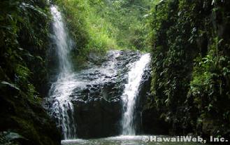
Maunawili Falls Hike
 |
This was the first time during our visit here that we'd actually driven through this kind of an area (except coming down from the overlook on our first afternoon here), and we had no idea how pretty this area is. As you can see from the picture of the residential district, and in this picture of a typical house in this neighborhood, the area is lush and green and, at least at this time of year, very wet. In both pictures of the neighborhood, you can see that is is surrounded by mountains- lush and green all year round. Here is another typical view from one of the streets near the trailhead; it is very common during the day for clouds to hang on top of the mountains in the central part of Oahu, since the wind is coming in from the ocean, pulled in by the rising air currents over the usually warmer land. At night, this movement tend to reverse, and clouds will often be pushed out to sea as a result (and this is why showers are quite common along the beaches in the early evening). We were there in November, of course, and the Hawaiian Islands get most of their rain in the fall, winter and early spring. Here is another typical mountain ridge with clouds as seen from a point near the trailhead.
 |
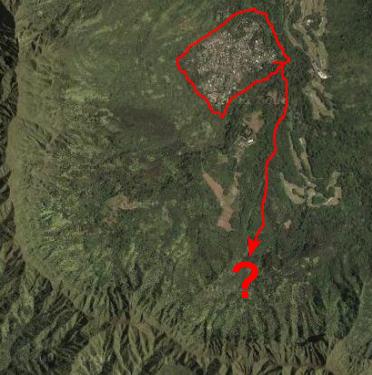 |
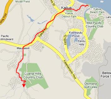
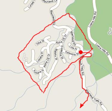
On the right is an aerial view that covers more ground. I have circled the corresponding map area on the aerial view, but expanded it to show you the surrounding ridge of mountains. This is really just a semi-circular mountain ridge, not the remains of a crater or anything. But it will help you understand what mountains were in the pictures that you saw earlier. I have also indicated on the aerial view the general route we took at the beginning of our hike. I like these aerial views, because it is always interesting to find things like the country club golf course that you see referred to on the surface maps.
Anyway, right near where we parked our car we found the entrance to Maunawili Trails Road that our guide information said we'd have to walk down a ways to find the trail leading off the road and up into the mountains. We almost rethought the hike when we got near the barricade and had a chance to read the warning signs (Hawaiians seem to LOVE lots of warning signs), but we decided to soldier on anyway.
We headed down the road and after about a quarter mile came to a trail that led off up to the right, and it was marked. So we headed up that way. Although the weather was warm, it was very cloudy and damp, and the trail was extremely muddy. We kept having to walk to the side or get off the trail completely as there was much evidence that people had been slipping and sliding on the muddy parts. It was slow going and not all that much fun. Fred found just enough interesting plants and flowers to keep it interesting, though.
After about a quarter-mile, we came to a small stream that the trail crossed. We stopped here to admire the rocky streambed and assess the trail thus far. It wasn't much fun trying to keep from slipping on the muddy trail; you couldn't just walk along and look around at the same time. So while we were standing by the stream at the trail crossing we decided to quit while we were ahead and call off the hike.
 |
|
|
We stayed for just a bit, and then headed back to the beach to play frisbee and collect Ron and Jay.
Pali Lookout
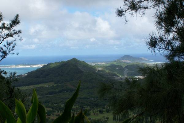 |
From there, you can get excellent views of Kailua and Kailua Harbor. There was also a very pretty view of the nearby mountain valley and Luana Hills Country Club.
Looking back across the lookout towards the center of the island, there were very good views of the cloud‑topped mountains behind us. And right beside the lookout, you can see the detail of one of the lush mountainsides.
|
|
It was crowded at the lookout; it is a popular place for tour buses to come. But we had to get on back to the hotel to check out and get Ron and Jay to the airport.
Leaving the Hotel
There wasn't much to do to check out. We had gotten back to the Waikiki Gateway Hotel in plenty of time for all of us to take a quick shower and change clothes, and that's what we did first. Ron and Jay were a bit subdued, because Jay had worn his glasses into the ocean over at Kailua Beach Park and had apparently lost them in the surf. He could still see to get around, but not very well, and I think Jay was worried that he wouldn't be able to enjoy the day they had planned to spend in San Francisco on the way back.
Since I am writing this narrative after we all returned from the trip, I can report that Ron was able to locate an optometrist that got Jay a quick prescription very early on Saturday morning, and Jay had some new glasses by late morning and he, at least, was able to see a lot in San Francisco and enjoy his day. Ron didn't enjoy their Saturday and Sunday morning quite so much; he had one accident with the rental car on Saturday morning- a fender bender on Mt. Tamalpais on the north end of the Golden Gate Bridge, and then another, more serious accident when he was sideswiped by another car on his way to the airport on Sunday. Somehow, I seem to have gotten the blame for both accidents because I drove them to Kailua Beach Park in the first place
Well, we got all changed and Fred and I got checked out first, so while we we were waiting around outside the
entrance to the Waikiki Gateway Hotel,
Fred walked around checking out some of the
street vendors.
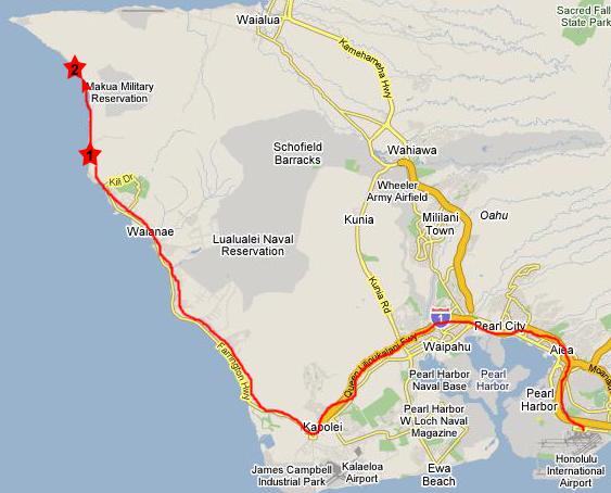
Once we collected Ron and Jay it was off to the airport. We had time to go past the airport and have some lunch at one of the same restaurants we'd already eaten at and still get the two of them to the airport an hour before their flight. Then, since Fred and I weren't leaving for about four hours, we took a trip to the west side of Oahu.
The Windward Side of Oahu
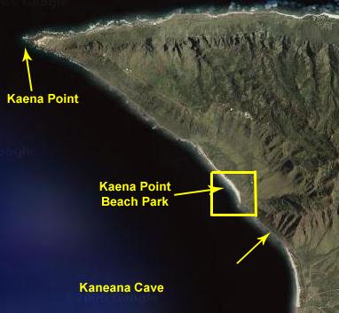
We took the expressway west from the airport, following the same route we'd taken to Germaine's Luau, but did not exit and continued west. The expressway ends and turns into Farrington Highway which passes through a number of smaller towns before going through the rather large town of Waianae. Then the development pretty much ceases and the real scenery begins. We made quite a few stops, the major ones being at Makaha Beach, just north of Waianae, Kaneana, the sacred cave further up the coast (#1), and, finally, Kaena Point Park (#2) where the road ends.
Makaha Beach
Once we got north of Waianae, the development thinned out and then pretty much stopped, and the real scenery began. The first really scenic place we stopped was
Makaha Beach,
a spectacular mix of rocks and sandy beach. This is one of the best surfing spots on this side of the island, and even midafternoon on a weekday there were
surfers trying their luck
with the waves. Part of the luck would be to avoid the rocks, I would think.
We walked around on the rocks for a bit, enjoying the warm breeze and watching the surfers; here is a picture, looking northwest, of
Fred on the rocks at Makaha.
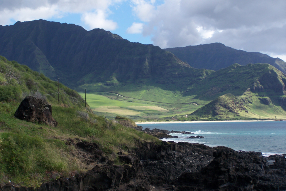
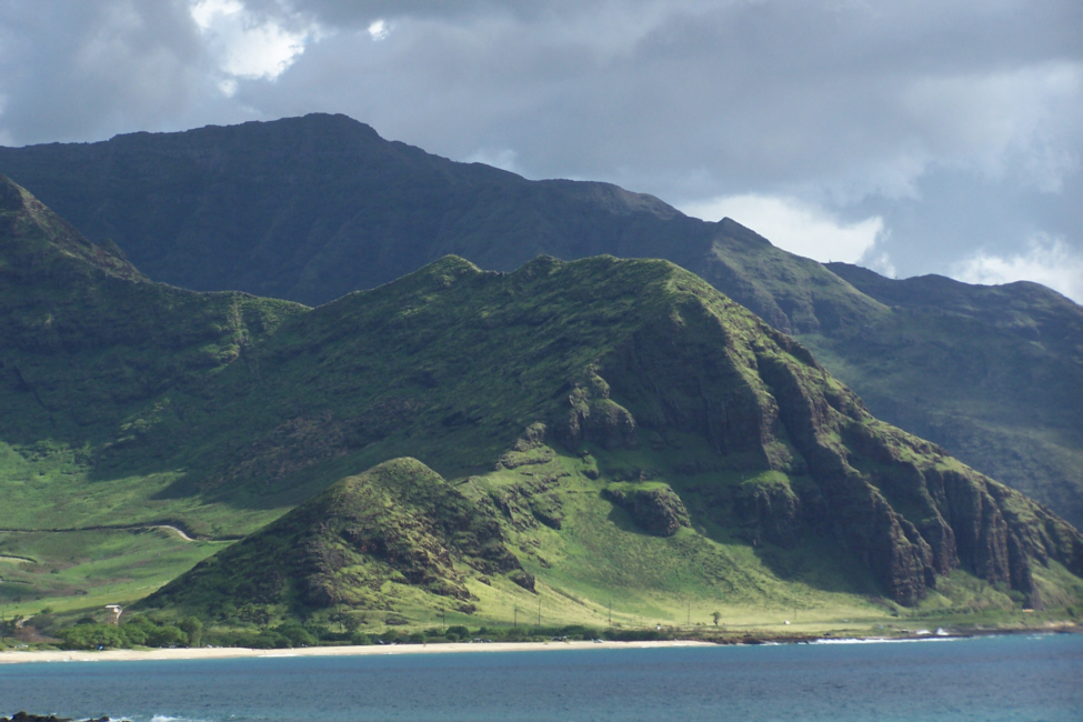
We got back in the car and started further north. The built-up area pretty much disappeared, and we were on an almost empty, beautiful coastal highway with the
dark green mountains
on one side and the rocky coast on the other. The highest mountains on Oahu are on this side of the island, and they certainly form a
beautiful backdrop
for any picture you care to take.
Kaneana Cave
Here at Kaneana, we made a stop to see the sacred cave. Just opposite the cave entrance there is a stone marker at the shore, and both of us thought it would make a good record marker for this stop on our trip, so there is a picture Fred took of
the marker and I
and a picture I took of
the marker and Fred.
We crossed the highway to the
entrance to Kaneana
and of course the first thing we noticed was that there were other visitors, even though there were no other cars in the parking lot. It just struck me as kind of funny that there should be a motorcycle parked at the entrance to the sacred birthplace of Hawaiians, but I guess that nothing's sacred anymore. Moving further into the
Kaneana Cave
you can see the other visitors that were here.
We went on inside the cave, and we took some pictures there, but for one reason or another (mostly because the main room was so large) none of the pictures turned out- even with a flash. Or maybe the Goddess was angry that there was a motorcycle parked outside her front door. Who knows? But the inside was interesting and the cave went back pretty far. We couldn't go any farther than the available light, though, since we didn't have flashlights with us.
Back outside in the parking area, we took some more pictures. The coast here is really spectacular. There is a picture, looking north, of
Fred and Makua Peak
and also a view of
Kaena Point.
We'll get closer to the point shortly, so I won't say more about it now. But you can see in my picture that there is a radar dome high up on the ridge (no more Pearl Harbors for us, don't you know), and Fred thought it would be interesting to see the
radar dome close up.
The parking area outside Kaneana Cave turned out to be a good place to take some pictures in both directions. All three of the pictures whose thumbnails are below look back from here down the coast highway we have just traversed; click on those thumbnails to view the full-size images:
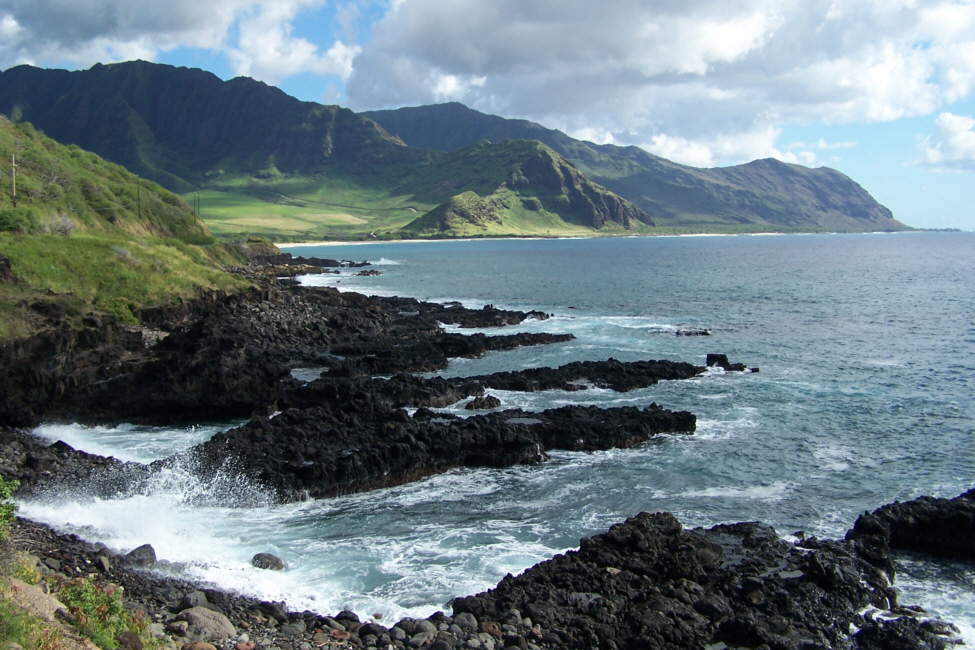
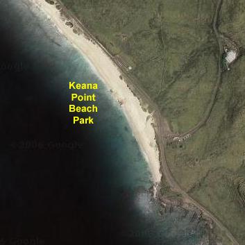
Kaena Point Beach Park
And this was literally the last stop we could make, for the highway ends just past the park beach. I don't really know why the highway has not been continued around the point and onto the North Shore; on the North Shore the highway ends only a bit farther from Keana Point than we are now. Perhaps there just wouldn't be enough traffic to justify it; I really don't know. I thought it unusual when I was last this far north in the 1970s, and it is even more odd now, what with the increase in Oahu's population since then. I suppose the most logical answer is that the point is too strategic militarily (there is a small military installation there) and having tourists plow through continually might be counter-productive.
In any event, Fred could now say that he has been the the northwesternmost point on Oahu (but not in the Hawaiian Islands, for there are two or three more small ones northwest of here). There was a
pretty nice beach
here and, as it has been all along the windward shore, the surf's up.
Well, we'd come as far as we could, and it was time to head back to Honolulu and our flight home. As we passed Kaneana Cave, we stopped one more time so I could get a good picture of
Fred on Oahu's windward shore.
Leaving for Home
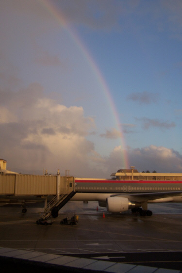
As we neared Pearl Harbor, and we returned to the misty, cloudy weather of interior Oahu, we were presented with a
beautiful rainbow
which seemed to be directing us; it was exactly in the direction we needed to go. Most times, rainbows tend to disappear quickly as you move and the light no longer hits the mist right, but this one led us all the way
to the airport.
Even after we turned the car in, took the shuttle to the terminal, passed through security and found our way to our gate, it was guiding us right to
the plane.
Well, not EXACTLY the plane- ours was on the other side of the concourse. But whoever was taking this Northwest Airlines flight home would seem to be in for a charmed flight.
We had a wonderful trip and a good flight home, getting back to Dallas very early Saturday morning. I certainly hope this wasn't our last trip to Hawaii, but, if it turns out to have been, we could hardly have done more or seen more than we did on this trip.
You can use the links below to continue to another photo album page.
It has been quite some time since I was on the windward side of Oahu, so I was looking forward to seeing it again, and looking forward to Fred's reaction as he saw it for the first time. One thing I was certain of was that the weather would be better on this side of the island; during the day, the trade winds keep this side of the island clear and the surf up (although the surfing is better on the North Shore).
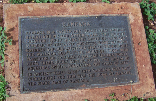
In ancient times, entry into Kaneana was 'kapu' (forbidden), for this was the home of Nanaue, the Shark Man of Kaneana.
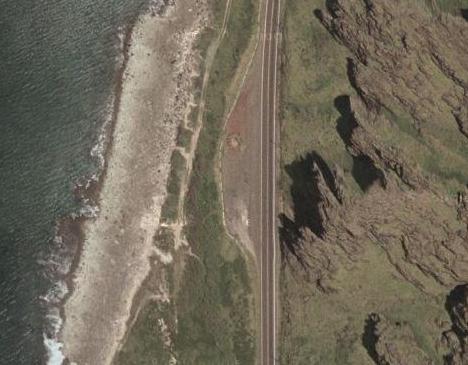
Because I thought it would be interesting, I've included an aerial view of Kaneana at the left. You can actually see the little circular island towards the top of the parking area where the marker in the last two pictures was located. (The resolution wasn't good enough to get any better view of the marker than this, but you can see the little boulders that surround it and protect it from being run into by cars.
While Fred was taking the pictures above, I was taking my own. Of course, I had to take one of
Fred taking his pictures.
I also found an
interesting relic
on the rocks below where we were standing. Finally, I thought I would take a movie of the Kaneana Cave shoreline, and you can watch that movie using the player at right.
From Kaneana Cave, we continued north just a few hundred feet along the highway to our last stop-
Kaena Point Beach Park.
You can tell by looking at the aerial view of Keana Point and the closer aerial view of the inset area above just about where we were standing when this picture was taken.
We drove through the sunlit afternoon back down the windward side of Oahu, and stopped in Waianae to have some lunch. Then we just retraced our drive from earlier in the afternoon and headed back to the airport on
the H‑1 expressway.
November 10, 2005: Hawaii Trip Day 6
Return to Main Index for Hawaii Pictures