|
November 11, 2005: Hawaii Trip Day 7 |
|
November 9, 2005: Hawaii Trip Day 5 |
|
Return to Main Index for Hawaii Pictures |
Waterfalls Coast Drive Leaving the Hotel
 |
|
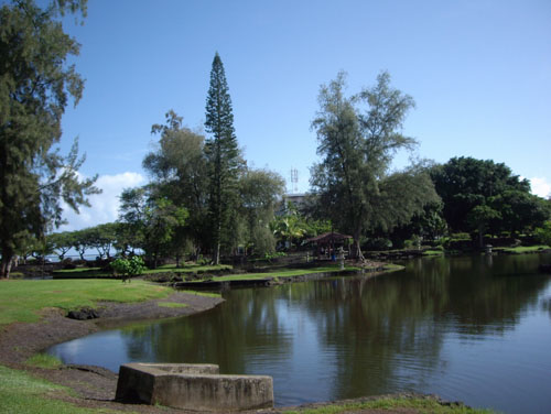
Right across from the Hotel there is an inlet from Hilo Bay that forms a lagoon where we had seen some boats and fishermen. It is probably part of the large park that begins just north of the hotel.
|
The Liliuokalani Gardens were quite pretty, but not very large. There were lots of pathways, small ponds and a number of Oriental pagodas and other small gazebos and seating areas.
After spending a few minutes here, we went back to the main street along the bay and headed west, then north, through the city and then up along the coast.
 |
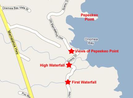
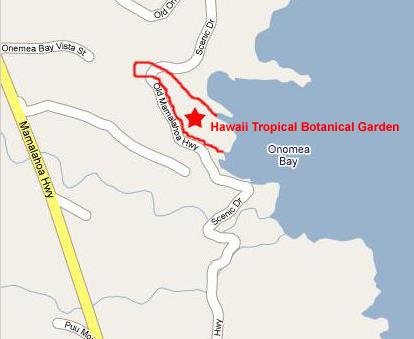
Our first few stops, including some waterfalls, a view of Pepeekeo Point and the Hawaii Tropical Botanical Garden, are all indicated as stop #1 on the map. I've put the pictures leading up to the Botanical Garden in this section; I decided to let the Garden have its own, since we did so much there and took so many pictures.
 |
Almost around the next bend in the road, Fred spotted this old church, which brought to my mind the entire story of New England missionaries in the islands, a story told so well in James Michener's Hawaii. Right nearby, Fred found another of what would turn out to be hundreds of unique Hawaiian plants and flowers.
|
|
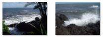
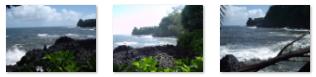
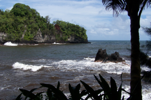
Heading on again, it was only a fraction of a mile until the road made a sharp turn and opened up a view of Pepeekeo Point and its famous Onomea Arch. Onomea Arch was the most notable work of the elements on this side of Hawaii, and it was carved from the cliffs by restless waterpower. Legend has it that King Kamehameha threw his spear to create a huge tunnel in the rock. A famous landmark, the arch has attracted visitors to Onomea Bay for many, many years. But Onomea Arch fell during an earthquake in 1956 after standing for thousands of years. Today the fallen arch appears as a wide crevice in the cliff on the north side of Onomea Bay, but this favorite Hilo landmark is preserved in antique postcards which recall its glory from the turn of the century.
PePeekeo Point forms the northern boundary of the Onomea Bay, which is quite spectacular in the juxtaposition of the dense forest and the waves crashing against the bare lava rocks. And this point offered excellent views of the bay, with its forest, waves and rocks.
Hawaii Tropical Botanical Garden
 |
The Hawaii Tropical Botanical Garden is huge. According to the guidebook, over 2,000 species, representing more than 125 families and 750 genera, are found in the garden. The 40-acre valley is a natural greenhouse, protected from buffeting tradewinds and blessed with fertile volcanic soil. Some of the Garden's enormous mango and coconut palm trees are over 100 years old.
The Garden was created through the efforts of Dan J. Lutkenhouse, who discovered Onomea Valley in 1977 while vacationing. He purchased a 17-acre parcel for its seclusion and beauty, and later decided to establish a botanical garden to preserve that beauty. When he bought it, the valley was an overgrown and virtually impenetrable jungle, choked with wild invasive trees, weed and thorn thickets, and strangling vines. Mr. Lutkenhouse sold his 40-year-old trucking business in San Francisco and moved here to develop the Garden.
For eight years, Dan, an assistant horticulturist and two helpers worked with cane knives, sickles, picks, shovels, and a chain saw clearing paths through the jungle. All the work was done by hand to avoid disturbing the natural environment or destroying valuable plants and tree roots. The men kept a slow and easy pace, and the work continued seven days a week until the Garden opened to the public in 1984.
Entering the Hawaii Tropical Botanical Garden
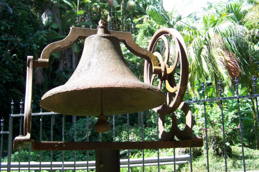 |
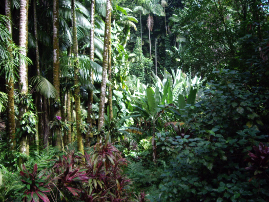
Dan and Pauline Lutkenhouse have transformed Onomea Valley from a dense jungle to a pristine tropical paradise. Plant specimens have been gathered from tropical jungles around the world and planted by hand. The entire valley is treated as a nature preserve. There are giant rainforest trees here that form the dense overstory canopy of Onomea Valley. These include 100-foot tall mango trees that were probably planted in the late 1800s, breadfruit trees that date from the early 1900s and towering coconut palms that are constantly pruned to protect visitors from falling fruit.
In the Hawaii Tropical Botanical Garden, exotic plants gathered from distant tropical rainforests grow side by side with native Hawaiian plants. Together they form a spectacular living work of art in the only tropical botanical garden in the United States that is situated on an ocean coast.
Descending the Boardwalk Into the Garden
A 500 foot long elevated boardwalk winds down the steep-walled, narrow ravine of Kahalii Stream that now runs dry because a 1949 landslide diverted all its water into Onomea Stream, and the Kahalii ravine boardwalk is lined with exotic tropical plants, including giant bamboo, bananas, flowering vines, orchids and ferns. Here is Fred coming down the boardwalk.
As we were coming down the boardwalk, and indeed all the time we were wandering through the Garden, both Fred and I were taking lots of pictures of plants and flowers. Of course, Fred, given his interests, took a great many more than I did. The Garden is organized into specific areas (some of which I'll describe), but we didn't deal with one area at a time but just wandered along the pathways.
|
Once again, using a slideshow is appropriate, as clicking on thumbnails and closing windows is itself time-consuming. But unlike other slideshows in this album, the sheer number of pictures mitigates against even a single show, and so I have broken the pictures up into smaller, but still substantial groups (about twenty pictures per group), and created a slideshow for each group. The first of these groups is here.
To view this first slideshow just click on the image at right and I will open the slideshow in a new window. In the slideshow, you can use the little arrows in the lower corners of each image to move from one to the next, and the index numbers in the upper left of each image will tell you where you are in the series. When you are finished looking at the pictures, just close the popup window.
Palm Vista
 |
At the end of the trail is the Palm Jungle; its towering Alexandra palms created the feeling of a church. Originally from Australia, Alexandra palms grow profusely in valleys along the Hamakua Coast. They have long, creamy flower clusters that appear below the fronds. These flowers produce huge clusters of seeds which turn from green to red. Then they fall and carpet the jungle floor to produce hundreds of tiny new palm tree seedlings.
After going through the Palm Jungle, we found Onomea Stream descending from the mountains through this glade of palms on its way to the sea. Onomea Stream has created what is referred to as the crown jewel of the Garden, Onomea Falls, which we will get to next. But we looked at the many palms for quite a while, including this one and its enormous leaves.
|
To view this second slideshow, again just click on the image at right and I will open the slideshow in a new window. In the slideshow, you can use the little arrows in the lower corners of each image to move from one to the next, and the index numbers in the upper left of each image will tell you where you are in the series. When you are finished looking at the pictures, just close the popup window.
Onomea Falls
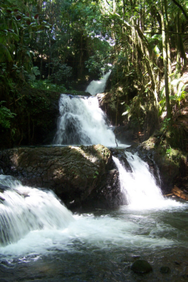 |
It was discovered far back in the jungle by Dan Lutkenhouse, about three years after work on the lower Garden began. (This gives you another indication how large the Garden is and how overgrown it must have been when the property was purchased. You'd think that a feature like this would be easily found.) He found it one day when he decided to hack his way through the jungle alongside the stream.
Onomea Falls is set amidst the natural forest of palms and ferns. It seemed even cooler here with the variety of mosses growing on the surrounding rocks and trees. We could see some small fish and prawns in the clear, cool water. These pictures were taken from a viewing bridge that has been built over Onomea Stream just below the falls. This was also an excellent place from which to take some movies.
Fred's movie of Onomea Falls, which you can watch with the player below, will give you an excellent appreciation for the falls, although it seems that his attention was distracted partway through filming by something high up in one of the palm trees.
|
|
|
|
|
To view this second slideshow, again just click on the image at right and I will open the slideshow in a new window. In the slideshow, you can use the little arrows in the lower corners of each image to move from one to the next, and the index numbers in the upper left of each image will tell you where you are in the series. When you are finished looking at the pictures, just close the popup window.
Onomea Bay
 |
|
|
|
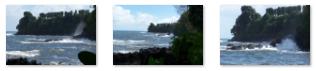
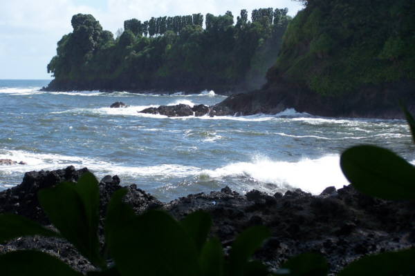
The trail continues to Turtle Point, the easternmost tip of the shoreline inside the Gardens, and from here you can get a good view of Rock Island, an outcropping of lava that is certainly accurately named. The views themselves are pretty amazing, but what really give you a feeling of having been there are looking at some of the movies we took. All three of these movies are of the wave action along the shorline of the Gardens from Bay Vista around to Turtle Point. We think they are all good, and you can view them using the movie players below:
|
|
|
|
|
|
|
To view the slideshow, just click on the image at right and I will open the slideshow in a new window. In the slideshow, you can use the little arrows in the lower corners of each image to move from one to the next, and the index numbers in the upper left of each image will tell you where you are in the series. When you are finished looking at the pictures, just close the popup window.
Crab Cove and Turtle Bay
 |
The boundary of the Gardens does not include either inlet, and the south fence of the Gardens kept me from climbing down along the shoreline to get onto the rocks in Crab Cove.
|
|
|
We were at the farthest point of the Gardens from the entrance, and so now we would be working our way back.
Back Into the Gardens
From the shoreline, the trail leads back up along the northern shore of Crab Cove. In this area there were more palms and a rainforest canopy. As we walked along the trail, we passed a replica of an ancient Hawaiian totem. I looked in the guide materials for mention of it or its significance, but I could not find anything about it.
|
The Gardens had apparently stationed an employee at this point for two reasons. First, he directed people who came up the trail and onto the road that to continue into the Gardens the had to turn right, walk past him and then onto other of the garden paths. Secondly, I can only assume that he is there to keep unauthorized people from entering the Gardens simply by walking or driving down that dirt road. I found it hard to imagine why a person would have to sit there when they could easily put a locked gate across the road, so I concluded that the employee is only there when the road is in use and it is inconvenient to lock and unlock the gate.
When I got to the road, I turned to go up it a short ways so I could get down to the shoreline, but the fellow kept me from doing that (perhaps the land next door is owned by someone who has only given license to the Gardens to traverse it), and called to me to come back into the Gardens.
Here is another slideshow full of beautiful pictures of the flora here in the Botanical Gardens. To view the slideshow, just click on the image at left and I will open the slideshow in a new window. In the slideshow, you can use the little arrows in the lower corners of each image to move from one to the next, and the index numbers in the upper left of each image will tell you where you are in the series. When you are finished looking at the pictures, just close the popup window.
Alakahi Stream and Boulder Creek Falls
From Crab Cove, we have followed the Alakahi Stream, and it has led us up along the shore to the dirt road and the way back into the main part of the Gardens. A little ways past the guard post, the trail turned again to follow Alakahi Stream up towards Lily Lake.
Here, another trail branches off and heads towards the Cook Pine grove, but what we wanted to see was Boulder Creek Falls. We had crossed Boulder Creek after our last stop before the Gardens on the Scenic Drive, but could not see where the sound of falling water was coming from. The trail continued along Boulder Creek for a ways so that you could get closer to the upper falls, a cataract about eight feet high. That's not very high as waterfalls go, but just the right size to set off this part of the Gardens.
The Parrot Aviary
The last stop we made in the Gardens was near Lily Lake at the Parrot Aviary. Here, there were a number of cages with quite a few parrots in them. They were noisy and moving around a lot, so it was hard to get pictures of them, but you can look at the best three pictures here, here and here.
|
To view the slideshow, just click on the image at left and I will open the slideshow in a new window. In the slideshow, you can use the little arrows in the lower corners of each image to move from one to the next, and the index numbers in the upper left of each image will tell you where you are in the series. When you are finished looking at the pictures, just close the popup window.
We enjoyed our visit to the Hawaii Tropical Botanical Garden, and would like to have stayed longer (well, at least Fred would have), but we had some other sights to see today, so we were off again.
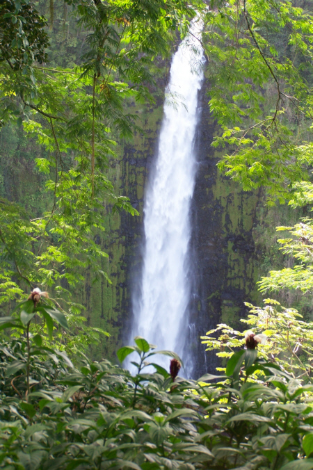
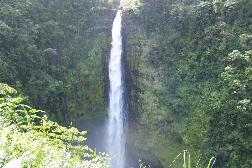
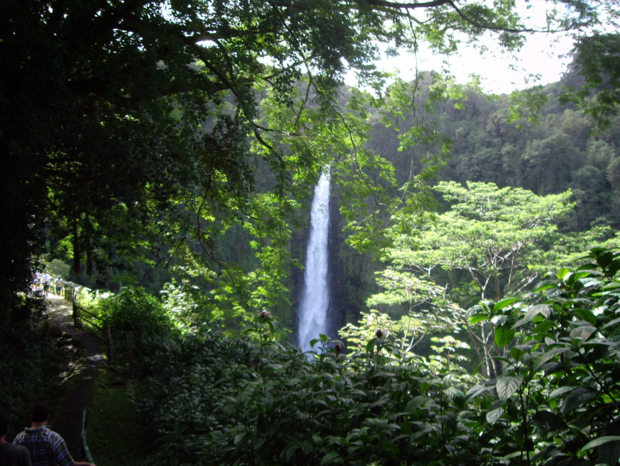
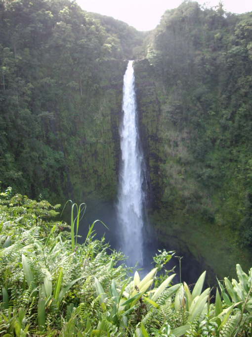
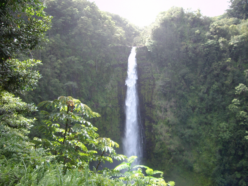
Akaka Falls
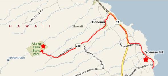
We got back in the car and headed further up the scenic highway towards Pepeekeo where we could get back to the main highway and head up to Akaka Falls. Just north of the Gardens, though, we found yet another small waterfall running underneath the highway. We stopped at the bridge to take a look (the red star on the map near PePeekeo Mill). The waterfall was on the high side of the road, of course, and the water ran under the bridge and down the stream towards the ocean. We were still pretty high up, so I would imagine that there must be another waterfall further on down.
 |
We parked and began to follow the paved trail to get out to the falls themselves. Just a short distance down the trail, we encountered one of the many small streams that ran alongside the trail, and just a few hundred feet further on we encountered a very small waterfall on another of the many streams we saw.
Having so many little streams and waterfalls nearby made walking along the trail quite pleasant. In many places, there was a railing along the trail to keep visitors from wandering off into the rainforest; here is Jay on the railing at a turn in the trail. The forest got quite thick in places, and at times we had to use a flash to take pictures, such as this one of Ron and Jay on the Akaka Falls trail. Along the trail we came on a thicket of banyan trees; they are the ones with the vertical root systems. At this particular tree, the aerial roots had dropped to the ground and rooted forming an enclosure of roots that was big enough that I could get inside it.
We continued along the trail walkway and pretty soon we were quite close to the falls. From there, we ascended to an observation point from which we could see Akaka Falls on the other side of the valley. This was still not a very good view, though, so we continued along the trail to the observation point from which we had an excellent view of Akaka Falls. Here is Ron at Akaka Falls, for example.
|
The last thing I did here at the overlook was to film a panoramic view of Akaka Falls and I think it turned out quite well. Watch the movie using the player below.
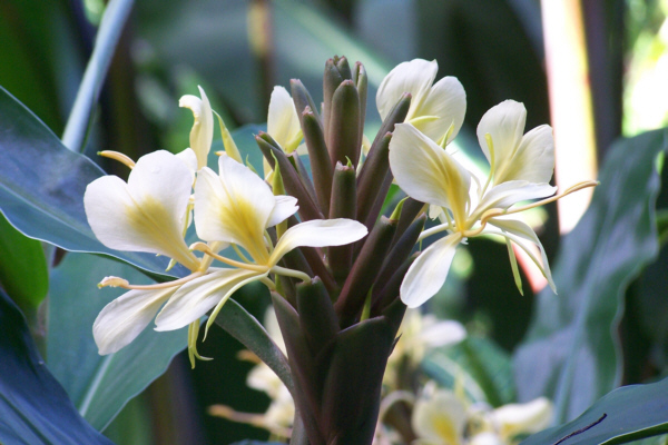 |
Along the way, Fred found even more flora worthy of a picture, and one of the best of those pictures is at left.
At one point, we passed a small waterfall hidden in the foliage near the side of the trail.
For the most part, it was an easy walk up the trail and there were lots of interesting things to see.
|
|
As we drove back towards the main highway, we stopped in the small town of Honomu. The stores on Main Street looked really interesting. We stopped and had a drink and one of them, and Fred wandered into an intriguing antique store where he found some unusual antique bottles to add to his collection. Then we headed on back to the main highway and went north again to our next point of interest- Laupahoehoe Point.
Laupahoehoe Point
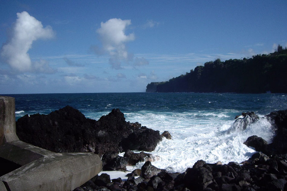 |
Laupahoehoe Point Park is a beach and recreation area, and there is a place to picnic or camp, a small beach, a boat launch ramp and a pier made of honeycombed concrete that protects the boat launch area and small beach from the worst of the pounding surf. Not only had the honeycomb of concrete been built here, but there were also huge concrete pieces that looked exactly like gigantic jacks that were placed along the shore to protect the park area from huge waves; they would serve to break them up before they could do too much damage.
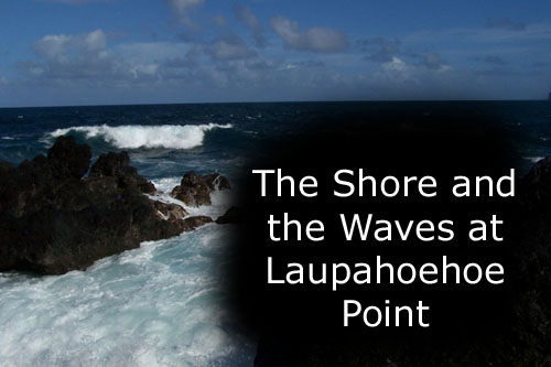
As you can easily tell from the picture at left, the views from here were spectacular, and the weather had really cooperated (today was as different from yesterday as could be possible- beautiful blue sky, moderate temperatures and a cooling breeze).
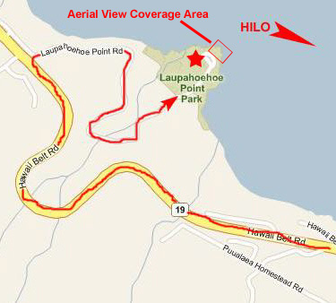
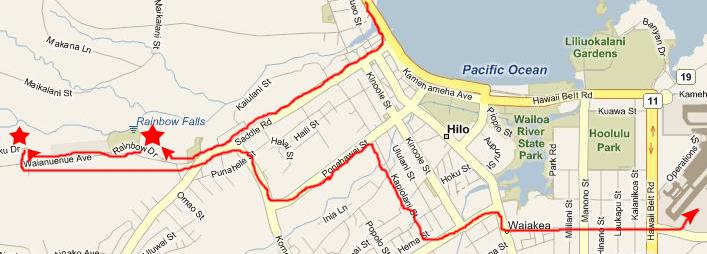
I found a very good aerial image of Laupahoehoe Point, so I'd like to present you with both a map and an aerial view:
 |
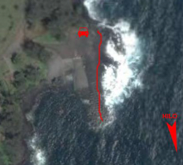 |
On the map, I've marked the route we took to get here and I've indicated the direction to Hilo. I've also superimposed a small box that shows you the area of the map that is covered by the aerial view beside it. On the aerial view, I've indicated where the car was parked (you will see it in some of the pictures and movies, so it will help you orient yourself), I've indicated the direction to Hilo and I've also drawn a line to indicate where one or more of us walked along the shoreline. All the pictures and movies were taken along that line. In the aerial view, you can clearly see the boat ramp and the honeycombed concrete structure that protects it; you will see both of those in various pictures and movies.
 |
 |
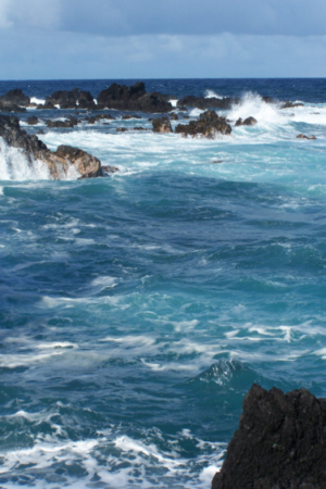
The recreational aspects of the park are, I am sure, valuable to the residents, but for us, the main attraction was the scenery, and THE major aspect of the that scenery that made it so spectacular was the shoreline itself. The contrast of the black, sharp lava rocks and the deep blues of the ocean was nothing short of amazing. Pictures don't tell the whole story, though. Only the movies can really capture the real flavor for what this place was like.
Below, I've put the usual thumbnails for most of the pictures we took here. I know we took a lot of them, and I don't expect you to look at all of them, but I hope you look at enough of them to get the feeling of this place, and perhaps also get the feeling that you'd been here. I've grouped the pictures into those of just the shore and the waves, those that contain one or more of us and the movies. At the very least, I hope you'll look at the four movies; they, more than anything else, will describe Laupahoehoe Point.
The Movies of Laupahoehoe Point
We took a number of excellent movies here at Laupahoehoe Point, and you can use the players below to watch them:
|
|
|
|
|
To view the slideshow, just click on the image at right and I will open the slideshow in a new window. In the slideshow, you can use the little arrows in the lower corners of each image to move from one to the next, and the index numbers in the upper left of each image will tell you where you are in the series. When you are finished looking at the pictures, just close the popup window.
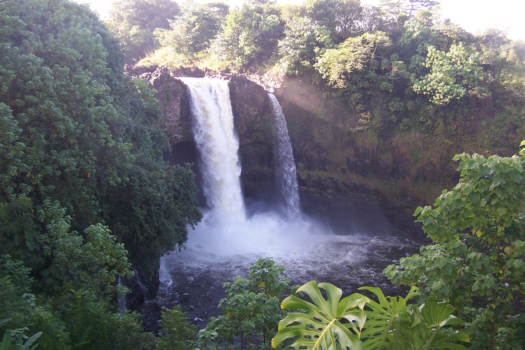
Now it was on to the last stop of the day, this one back down in Hilo- Rainbow Falls.
Rainbow Falls
 |
 |
|
|
|
|
|
|
|
|
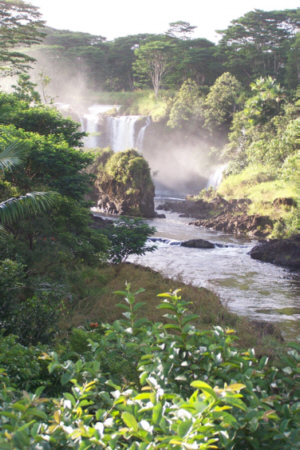 |
Again, perhaps this movie of Boiling Pots State Park will give you an added dimension and help you appreciate what we were seeing. Watch it using the player below:
|
|
Well, this was the end of our visit to the Big Island. It has been a wonderful three days here, but now we have to head to the airport, turn in our car (Ron and Jay turned in their separate car yesterday afternoon) and board the Hawaiian Airlines flight back to Honolulu.
The Waikiki Gateway Hotel
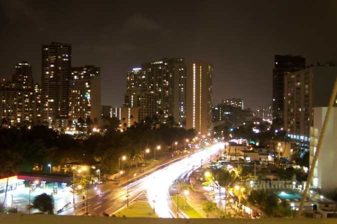 |
I made reservations at this hotel because it was a bit further away from Waikiki Beach and consequently a fair amount cheaper. We weren't planning to go to the beach tomorrow, but rather to drive over the east side of the island for that, and for some hiking. Ron and Jay had to leave in the early afternoon anyway. We made the rounds of a few bars, and walked down to Kuhio Street for a while, and that was it.
You can use the links below to continue to another photo album page.
|
November 11, 2005: Hawaii Trip Day 7 |
|
November 9, 2005: Hawaii Trip Day 5 |
|
Return to Main Index for Hawaii Pictures |