|
July 4, 2006: Holland Falls and the Going-to-the-Sun Road in Glacier NP, MT |
 |
July 2, 2006: Natural Bridge SP, Thermopolis and Shell Creek Falls, WY |
 |
Return to Glacier National Park Trip Index |
Monday, July 3, 2006
Shell Creek Campground, Wyoming to
Missoula, Montana
Shell Creek Campground
The night in the Shell Creek Campground was one of the best ever. The area was very secluded, with only a few campsites, and we got a prime location right by the river. The sound of water is one of the most restful in the world. Awakening in the morning, we walked over to take a look at Shell Creek itself, taking a picture first of
me beside Shell Creek
and then one of
Fred beside Shell Creek.
The morning air was quite cool at this altitude and at this time and the creek was just as picturesque as it looks.
We found out later that Shell Creek flows generally west until it empties into the Bighorn River (the same river that flows through Thermopolis). Then, the Bighorn flows generally north into Montana, where it, in turn, empties into the Yellowstone River. The Yellowstone River flows generally northeast through southeastern Montana to empty into the Missouri River. The Missouri, of course, flows east and then southeast to finally empty into the Mississippi just above St. Louis. Later in our trip, we'd cross the Missouri itself at Great Falls, but that would be a good deal west of where the Yellowstone meets the Missouri.
On our last day, on the drive home, we'd parallel the Missouri for a time as it runs along the border of Nebraska and Missouri. It was interesting to wonder how long it would take the water that flowed by our campsite that morning to reach that portion of the Missouri- probably longer than the time our vacation took.
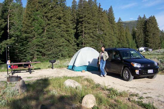
Our Campsite |
|
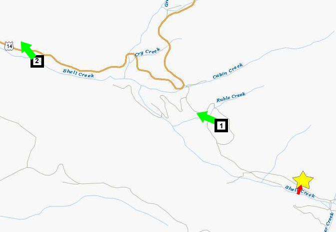
So you can get a good idea of what the creek and the campsite really looked like, I thought I'd take a movie as we walk from Shell Creek, through a grove of trees to the campsite (following the short red arrow on the map); you can watch this interesting movie using the player at right. Once there, you can see a picture (at left) of the campsite (looking back through the trees to Shell Creek, and one of the
campsite
looking west back towards Shell Falls and Greybull. Behind Fred is the dirt road that led down to the campground from the turnoff from US14, and, of course, the road that we took to head back.
Below is a movie we made at the campsite:
After breaking camp, we drove back to the highway, and here is a view of the
Bighorn National Forest
looking west from the point on the dirt road at point #1 on the map. We took the dirt road back to the highway, and then headed back west, getting this view of the
Bighorn Mountains,
taken along the highway at point #2.
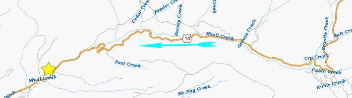
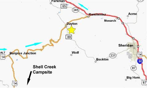
Shell Creek Cascades
As we came down out of the Bighorn National Forest, we stopped at what we thought might have been Shell Falls the previous afternoon. As it turned out, it was just a point (marked on the map with a yellow star) where
Shell Creek
came right to the roadside, crossed under a
footbridge
and then continued on westward through the
canyon
towards Greybull (where it empties into the Bighorn River). Actually, we found that the footbridge was really for horses, as there was a horse trail on the other side of the creek and a corral as well.
We also encountered a group of
cyclists
who were stopped here. We had been passing some of them on our way down the highway, and we found from talking to them that they were from California and were doing a week-long bike trek- averaging 90 miles a day, they said, with support vehicles and the whole ball of wax. There was a checkpoint right where we stopped. The last cyclists were arriving just as we got there, and a few of them prevailed on us to take a picture or two of their group with their own cameras.
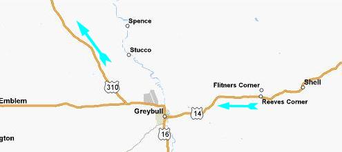
We went as far as Greybull, where we stopped to get some gas. Then we started looking at the map. Our intended route would have taken us further west on US14, through Cody, Wyoming, and then across and through the top portion of Yellowstone National Park. The lady at the gas station told us that since this was July 4th weekend, the traffic on that route would likely be very, very heavy. There were one or two small waterfalls that we had missed when we visited Yellowstone years ago, but the idea of getting caught in a lot of traffic was enough to cause us to decide not to continue west, but rather to turn north just west of Greybull on US310, go through Lovell, Wyoming and right on into Montana. But that decision, too, got changed as we drove along.
The Medicine Wheel National Historic Landmark
By the time we reached Lovell, Fred had done some in-car research and found that there was an ancient site in the Bighorn National Forest known as "The Medicine Wheel," and we decided that it would make an interesting stop (the yellow star on the map). Unfortunately, to get there, we'd have go go back east from Lovell on ALT US14 and back into the Bighorn National Forest. This wasn't a particular problem, but we were just kicking ourselves a bit that we hadn't considered this route earlier. If we had, then if we had just turned the other way on Highway 14 when we left the campground this morning, we would have intersected ALT US14 in just a few miles, and then it would only have been about ten miles back west to the Medicine Wheel. We estimated that we might have saved a couple of hours. But then we wouldn't have seen the Shell Creek cascades, and might also have continued on to Yellowstone- possibly getting caught in traffic. We also saw another waterfall marked on the map, so we didn't really concern ourselves too much about the change in direction.
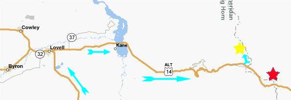
So, at Lovell, we headed east on ALT US14 (US14A). Right at the intersection where we turned, there was a visitor center for the Bighorn National Forest, so we stopped in to see what else would be of interest. The ranger on duty pointed us to Porcupine Falls (the red star on the map, near as I can tell), telling us that it was more interesting than the falls we had intended to visit, so we took his small hand-drawn map with us and headed east on the highway, through the
Bighorn Basin
and back into the mountains. The
road up the mountains
out of the Bighorn Basin was steep and winding. There were spots where I could tell Fred was a bit nervous (sitting on the passenger side where the drop-off was), so I tried to drive extra carefully. (Little did we know that someone nervous about heights didn't want to be a passenger in a car going across the Going To The Sun Road in Glacier National Park- at least not going west to east!)
When we finally got to the top of the ascent, we found a vista point that turned out to be an excellent place for a panoramic movie covering most of the Bighorn Basin, a movie you can watch with the player at right.
As soon as we left the vista point, we were in the wholly different landscape of the
Bighorn National Forest.
As we drove through the national forest, we watched carefully for the marker to the Medicine Wheel, found it without trouble, and then took a gravel road up to the Historic Site on top of Medicine Mountain- one of the tallest mountains in the national forest. (The only taller peak was occupied by the FAA facility referenced in the sign describing the Bighorn Basin that you probably saw a few pictures earlier.) We parked at the ranger station and chatted with the female ranger for a while. It turned out that she was from Texas, and spent her summers rangering up in this part of the country. We learned that this site is just one of many
stone circles
that are scattered throughout this part of the country. Many of them are called "medicine wheels," but this one is, apparently,
The Sacred Circle,
one of the largest, most well-known and most revered by native Americans.
The trail to the site is actually a
park road,
but private vehicles are not allowed. The
first part of the road
is fairly level and takes you about a mile and a half from the ranger station. It goes beneath the mountain where the FAA Control Facility is located, as you can see in this picture looking back towards the ranger station. Ahead, the
road
starts climbing up to The Medicine Wheel. The point where the road starts upward is the
Five Springs Basin Overlook.
This area, Five Springs, is called the
Crossroads of Culture
because of the many ancient trails and roads that intersected here. The rain was threatening, so we headed on up the
road to the site.
Reaching the Medicine Wheel itself (watch an excellent movie of it using the player at left), we spent some time wandering around and marveling at the
stonework-
which is, apparently, something of an
archaeological mystery.
There is a
path around the wheel
and Fred and I spent some time walking completely around it. Visitors to the site have left
prayer objects,
which we understand are, in many cases, offerings to whatever spirits caused the construction of the wheel. But no one, apparently, knows the real story of the construction of the Medicine Wheel- when it was built and, more importantly, why it was built. We were told that local Indian tribes said the stones had been in place when they first arrived in the area, which would make the Medicine Wheel old indeed. In one last picture taken at the site, Fred wanted to capture the passage of time by combining the
old and the new-
actually, the very old and the very new. I think he did an excellent job of expressing visually the wonderment of the average person who can't quite understand how we got from living with almost no technology to being totally dependent on a very, very complex form of it.
The weather was becoming more and more threatening, what with the lightning and thunder. A ranger had driven up to the site, and was just waiting around; I think he was there to hustle people back to the ranger station and their cars if the lightning got any worse. We headed on back down the trail, past some of last winter's
snowfall
to the SUV, intending to follow the ranger's instructions to find Porcupine Falls. Whether we missed a crucial sign (which we don't think we did) or the ranger's directions were incorrect (which didn't seem probable) or a sign was simply missing at the highway (most likely), the upshot of our searching was that we couldn't find Porcupine Falls at all. By the time we were certain we'd missed it, we'd gone too far east to retrace our steps, so we decided that the quickest way back west and into Montana would actually be to head east to I-90.
As it turned out, we crossed the junction where US14, the highway we'd taken to Shell Falls and the campground the evening before, intersected with US14A. This meant that, had we thought of it the day before, we could have saved time by just continuing on US14 to the junction, then west on US14A to the Medicine Wheel, and then on west and north into Montana. We thought we'd wasted a lot of time, but then we would have missed finding out about Porcupine Falls (which we missed anyway) and we would have missed visiting a pictograph site that we ended up seeing near Billings. So, I guess it was a wash, either way. We weren't particularly put out, and the drive was a pretty one. After we got down out of the National Forest, we stopped in the little town of Dayton, WY, found a
city park,
and had our
lunch.
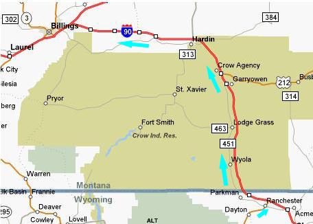
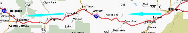
Then we continued east to Ranchester and then northwest on I-90 towards our next stop near Billings, Montana.
Pictograph Cave State Park
We headed north on I-90 (it's odd that an even-numbered interstate highway goes north-south; I keep misnaming it as I-25) towards Billings, crossing into Montana right at the boundary of the Crow Indian Reservation. Up in the Bighorn Mountains, the weather had been cloudy, cool and rainy. But in the distance we traveled coming down the mountain range, the weather changed completely- to sunny and warm with clear skies. From that point on in our trip, rain was pretty much unknown- except for a few brief showers in Glacier National Park.
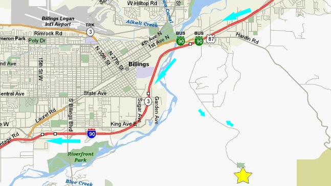
We got into Billings about two o'clock in the afternoon and stopped for gas at the intersection of the road to the State Park and I-90. Then it was eight miles straight south to
Pictograph State Park.
Pictograph State Park dates from the early part of the 20th century when the first
archaeological excavations
were performed and the area was documented. Shortly thereafter, it became a state preserve and then finally a state park. I believe that most of the artifacts found were taken to universities and museums throughout the area- there is relatively little on display here (perhaps because the site would be hard to secure).
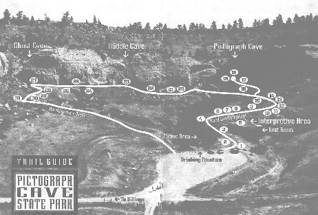
There is an easy, 1-mile circular hike along the cliffs that form a bowl enclosing the Park on three sides (See the trail map below). We went counterclockwise around the trail, which begins and ends at the entrance sign, visiting Pictograph Cave, Middle Cave and Ghost Cave. The first stop on the trail is
Pictograph Cave.
This cave has some old
wall structures
that remain from the time that this area was home to some early
Native Americans.
Of course, there are quite a few
pictographs
but most of them are hard to decipher. I may be imagining things, but the pictographs shown
here
look like rifles to me, which would make them considerably more recent that other discoveries made in the area. Right next to Pictograph Cave there was a
pictograph legend
and I can see the "rifle" pictographs as an entry in that legend. Our photo of the legend, unfortunately, didn't take in all the explanations. I suppose I'll have to search on the Internet sometime to see if I can find them.
From Pictograph Cave, the trail follows the cliff face, and
here
is a view looking from Pictograph Cave towards Middle Cave. Along this portion of the trail, there was an excellent view of the
"bowl"
that is formed by the circular cliffs, and you can see the parking area, the beginning and end of the trail and the countryside beyond. All along the trail, there were explanatory signs, like this one describing the
geology
of the area. This view looks backwards along the trail towards
Pictograph Cave,
and here is
another view
taken in the same direction.
Arriving at Middle Cave, I thought this would be a good time to show you a movie of the Pictograph Cave Trail so that you can get oriented. Watch it using the player at right. Here at
Middle Cave
there were also some pictographs, but they were very hard to see. We walked on to the last stop on the trail- Ghost Cave. The most interesting thing about this cave were the
rock formations
that almost looked as if they'd been carved separately and then glued in place in the cave. In actuality, the spherical formations were nodules of a material harder than the surrounding stone, and were revealed by erosion. The principle at work here is much the same as the formation of mesas and buttes when the relative hardness of a caprock protects the underlying rock from erosion for a time.
On the way down the trail we could get better views of
the area
taken in by the state park. After spending an hour or so at the state park, we retraced our route back up to I-90, and then continued west. Our next point of interest was about three hours away- Lost Creek State Park.
Lost Creek State Park and Lost Creek Falls
From Billings, we had to go quite a ways west for our next stop- Lost Creek State Park. First, it took us the better part of three hours to get from Billings to west of Bozeman. Incidentally, had we gone across the top of Yellowstone National Park, we would have come back to I-90 on US89, which you can see coming in east of Bozeman. But we would have missed the Medicine Wheel and the pictographs- two stops of particular interest for Fred.
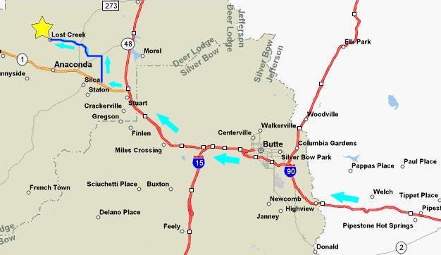
It took us another hour to get to the intersection of I-90 and I-15 near Butte, MT. I-15 heads north to Great Falls, MT, and south all the way to Las Vegas and Southern California. But we continued west along I-90. The
scenery
along the interstate was amazing. The picture was taken at the yellow star on the map, looking off to the forested mountains. It is so beautiful that you almost become oblivious to it after a while; it is certainly more scenic than anywhere near Dallas.
We left I-90 temporarily at Montana 1, a scenic road that goes through the old mining town of Anaconda (named for the copper company). Just before reaching the town of Anaconda, signs point the way about six miles to Lost Creek State Park (marked on the map with the yellow star).
At Lost Creek State Park, we drove back to the parking area for the campground, which was also the
trailhead
for the short walk to
Lost Creek Falls.
As seems to be true with most waterfalls, still pictures just can't do them justice, so let's begin with a panoramic view by watching a movie of Lost Creek Falls- using the left-hand player below. While I went off to clamber up to the top of the falls, Fred shot this excellent picture of the
falls.
Having arrived at the top of the falls, I was able to take a picture of
Fred
at the bottom of Lost Creek Falls, as well as this close-up shot of the
upper falls.
Finally, we end with another movie, this one taken from the top of Lost Creek Falls; have a look at it using the right-hand player below:
We went back down the short walk to the trailhead, which is also the fee station for the campground. There were quite a lot of campers in the park, and it didn't look as if there was an empty space to be had. Too bad, because the
mountain scenery
was really beautiful, as was the
moon
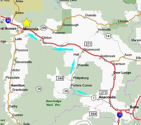
over Lost Creek State Park. In any event, we had plans to get to Missoula for the evening, to position us for Glacier National Park the next day.
We continued west and then north along Montana 1- one of the most scenic roads in that part of the state. The light was failing or there would have been many good pictures of first the mountain scenery and then the fertile valley in which the rustic town of Philipsburg and the towns of Maxville, Hall and Drummond all lie. We hit I-90 again, and then it was west to Missoula and our room at the Super 8 Motel. We'd hoped to eat dinner at the local IHOP but, unlike the ones around Dallas, it wasn't open 24-hours and we just missed it. We had a good meal at the "2 Bs" diner, though. Then it was off to the hotel to plan out our route for the next day.
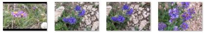
Today's Flora
To see a full-size picture of any item, please click on the thumbnail:
|
(Click on Thumbnails to View) |
You can use the links below to continue to another photo album page.
|
July 4, 2006: Holland Falls and the Going-to-the-Sun Road in Glacier NP, MT |
|
July 2, 2006: Natural Bridge SP, Thermopolis and Shell Creek Falls, WY |
|
Return to Glacier National Park Trip Index |