|
July 5, 2006: A Day in Glacier NP, MT |
 |
July 3, 2006: The Bighorn Wilderness, WY and Lost Creek SP, MT |
 |
Return to Glacier National Park Trip Index |
Tuesday, July 4, 2006
Missoula, Montana to
St. Mary Campground
(Glacier National Park, MT)
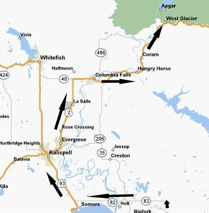
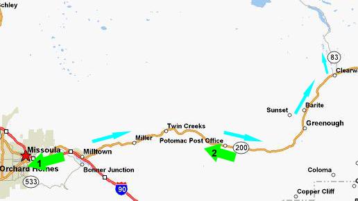
We started out from Missoula, Montana, fairly early. We had decided the evening before that we would take a somewhat longer but more scenic route up through Kalispell. We could have gone west from Missoula, and then up a national highway to Kalispell, and the route WAS marked on the map as being scenic, but my Internet investigation had revealed that the route further east, up through Seeley Lake, was more scenic, just as good a road, probably less traffic and dotted with waterfalls and other stops along the way. Even though we wouldn't have time to see them all, we planned to stop at a couple of them.
So we headed back east on I-90 just a short ways to the turnoff for Montana Route 200 east. As I was driving along I-90, Fred was trying to get a good picture of
Missoula
out the car window. He took quite a few of them, but there always seemed to be a power line or something else marring the shot. But the one we've settled on to include here (taken at Point #1), while it doesn't show much of the town itself, does show the scenic nature of the area in which Missoula is located.
We followed Montana Route 200 through the town of Greenough. All along the way, we were paralleling the
Blackfoot River
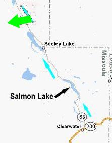
(taken at Point #2), which was very scenic along this entire stretch of highway. At the town of Clearwater, Montana, we turned north on Montana Route 83 towards Seeley Lake.
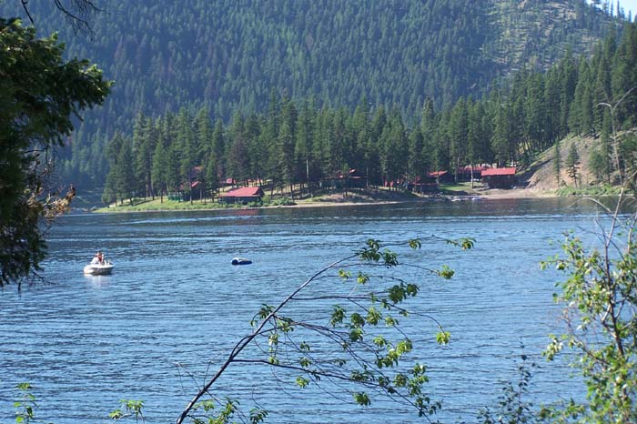
A short ways after we turned north on Montana Route 83, we passed the south end of Salmon Lake. It seemed to be a popular recreation spot, as we saw many boaters on the lake and picnickers along the shoreline. There seemed to be a combination of private residences and small resorts dotting the area. A bit further north, just before we passed the north end of the lake, we saw these picturesque
islands
out in the lake.
 |
We continued north into the town of Seeley Lake. It seemed as if the entire town was in the midst of preparations for a July 4th celebration, so we thought we should stop and ask someone local about the waterfalls that we'd seen on the Internet. As chance would have it, the store we chose to stop in to was a curio/antique/tourist affair, and, as it turned out, they had a good deal of buffalo-themed merchandise. I'm always on the lookout for stuff to squirrel away for Fred (to add to his already too-big-for-his-house collection), and this store had quite a few items I'd not seen elsewhere. I found a really nice storage seat (you can put magazines and stuff inside) that had an inlaid buffalo carving on the front- just the thing for the hallway outside Fred's downstairs bath. I decided to get it, and was in the process of arranging for it to be shipped home when I realized that we hadn't flown up here, but driven- and so we could simply put it in the back of the SUV and take it home ourselves. Duh! I don't know what I'd been thinking of; my only defense was that this has been our first long driving trip in quite some time, and I just wasn't used to it yet! Anyway, we got a lot of neat stuff- including some delicious homemade fudge.
It also turned out that one of the ladies running the shop knew quite a bit about the area, and knew about the waterfall we'd seen on the Internet. When she described the route to get there, though, we figured that it would take quite a while up and back- perhaps more time than we had. Even further, she said that the July 4th celebration and parade, when it began in an hour or so, would close all the town streets save for the main highway, and this might "lock us in" even longer when we returned from the hike. So we decided to bypass the falls at Seeley Lake, and continue up the highway to the next set. Loading the SUV with all our purchases (I am certain they were happy we'd stopped in), we headed on up Route 83. Along the way, we were paralleling the
Mission Mountains.
At one spot, there was a verdant pasture right alongside the road (marked by the green arrow), that had a good view of the mountains as well as some
horses
grazing contentedly. In addition to the picture Fred took of me with the horse/mountain background, I also took one of
him.
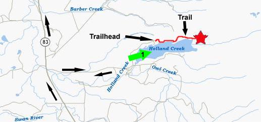
Holland Lake and Holland Falls
The Internet had quite a bit to say about Holland Falls, and it was one place we had definitely planned to stop. There were signs along Route 83 for Holland Lake, and the lake itself was about three miles from the highway. We took a dirt road into the campground and picnic area to get our first look at
Holland Lake.
This view (looking in the direction of Arrow #1 on the map) looks across one side of the "L"-shaped lake, and directly towards Holland Falls (although we didn't realize that until we returned from the falls themselves. It was a little early for lunch, but we planned to stop back by this same spot after our hike to have something to eat. We continued around the northwest side of the lake to the parking area and the
Holland Falls Trailhead.
We set out along the trail which initially wound through the
shady woods
and then dropped down closer to the shore of the lake. Then it followed the lake shore pretty closely. Along the way, there were a number of excellent views of
Holland Lake
and the
Mission Mountains.
After about a mile or two, the trail arrived at the falls.
The only way to appreciate waterfalls is through video. Of all the movies we took here at
Holland Falls
would be this first one, showing Holland Falls from top to bottom (watch using the left-hand player below) and this one, which shows Holland Falls from bottom to top (watch using the right-hand player below). Both will give you an excellent idea of what the falls were actually like. You'll almost be able to feel the spray!
As usual, I went climbing around on the rocks below the main falls, and got a good view of the
lower cascade
and this view of the
upper falls
from a point right below the pool. Fred followed me down to the rocks, and we spent some time looking for and finding some small rock souvenirs to take home, and I got a good picture of
Fred and the lower cascade
of Holland Falls. As with most waterfalls we've hiked to, it was hard to leave and trek back to the parking area. Fred usually leaves the movies to me, but on the way back he found these folks trying to keep cool by swinging into the lake, and you can watch his movie using the player below:
As we planned, we drove back to the picnic area at the other end of the lake from the falls and had our lunch. Here, each of us took a picture looking back across the lake to Holland Falls. In the first picture, that I took with no zoom, you can see Holland Lake, of course, but you can pick out the bright white of the
upper cascade
of Holland Falls pretty clearly. In the picture Fred took, he used his zoom to highlight
Holland Falls
even better. Just after we finished eating, Fred used his zoom again to look in the other direction to focus on the
Mission Mountains.
Now it was off to Glacier National Park. We took Route 83 north and then west, around the top of Flathead Lake to meet up with US 93. That's the other highway we could have taken from Missoula. Now, what with our buffalo purchases and the excellent hike to Holland Falls, we were very glad we hadn't taken that way. Then it was on into Kalispell. We made a quick stop at the local Wal-Mart, and I found some excellent steel tent stakes to replace the aluminum ones we've been using for years (they've gotten all bent and it's hard to pound them into anything but fairly soft ground without bending them further), plus a rubber mallet to make pounding easier (easier than using rocks). Then we took US Highway 2 north and east towards the town of West Glacier, entrance portal for Glacier National Park.
Glacier NP: Lake McDonald and McDonald Lodge
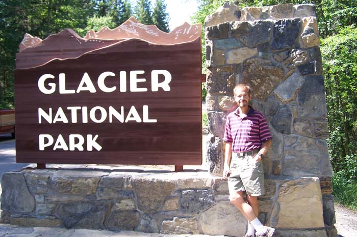
West Glacier, Montana, is a very picturesque town just outside the actual entrance to the park. I imagine it is almost totally supported by tourism at the park, for it was chock full of hotels, motels and restaurants, or other businesses that would thrive on an influx of tourists. It could have been a tacky place, but it seemed restrained and not overdone. Later in the trip, we contrasted it with a similar tourist town just outside Mt. Rushmore.
We paid our park fee (next time we do a trip where we go to so many parks, I will remember to buy a yearly pass, as we would have saved about $20 just on this trip alone) and drove into the park. The sign at the West Entrance (see map below, right) was a good backdrop for a picture of me and one of
Fred
to record our entrance into Glacier National Park.
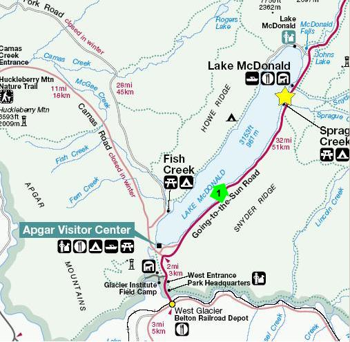
We needed to pick up some brochures and maps and get some advice on places to stop on our drive through the park, so we turned off the GSR (Going-to-the-Sun Road) and stopped at the Apgar Visitor Center. This was a tourist mecca, it seemed, with the only souvenir shops and fast food stands that we saw in the park. Better it was all gathered in one place than spread all over the spectacular landscape.
We did find the Ranger station and talked at length with one of the rangers about what to see and do. We noted a good many stops along the GSR, and added trips to Many Glacier and Two Medicine to our list. There were so many points of interest, waterfalls and hikes along the GSR that we planned on doing all of them in the first half of the road today, then bypassing the rest of them to get to our reserved campsite at St. Mary this evening. Tomorrow, we'll backtrack to do the hikes we missed on the GSR and also visit Many Glacier. The day after tomorrow, on our way out of the park, we can visit Two Medicine. It seemed like an excellent plan, and so we headed off.
A mile or so past the Visitor Center, we got our first good look at
Lake McDonald
(from Point #1 on the map). There is a small dam at the south end of the lake, but it only serves to keep the lake level stable; the lake itself is natural and fed by McDonald Creek. Although we had entered Glacier NP at 3:30 in the afternoon, we weren't concerned about doing a lot of stuff before getting to the campground because we were so far north and so far to the western edge of the Mountain Time Zone that it was staying light enough to hike or sight-see until almost 9:00 in the evening.
We continued to travel northeast on the GSR, and made our first stop at the historic McDonald Lodge on the shore of Lake McDonald (yellow star on the map). This photo was actually taken from the lake side of the lodge. When you first arrive at the lodge area, there is a double driveway in front taking you about 300 feet from the GSR to the lodge itself. There is parking along this driveway. When you walk down to the lodge, you are at its front, with a curved entry drive and a large porte-de-cochere. Here, we got our first look at the propane-powered
Glacier NP Tourbus.
It turns out that, where needed, each of the major national parks has its own fleet of these motorcoaches to take visitors through the park. Not every park has them, but in parks like this one where the conditions are right (the GSR is closed entirely to RVs above a certain size, parking space at the overlooks, points of interest and hikes is quite limited and just driving the GSR is a bit scary), you will find a fleet of them. For a fee, they will make various trips within the park so tourists can see the sights but leave the driving to someone else.
We also found out that the vehicles ordered by and used in the various national parks are all different. In one park, they might be yellow or some other color, or they might be ordered with special logos or paint stripes or something like that. Here, in Glacier NP, they are
bright red
with the
Glacier NP logo
on the side. We saw them often on our travels through the park, and they seemed to add a really nice touch. They must be popular, for there were a lot of them and, when we saw them, they were usually full.
We walked around the side of the hotel to get down to the shore of
Lake McDonald
where there was an excellent
viewpoint
just ideal for picture taking. McDonald Lodge is like a small resort, and some people may stay a while here, using the lodge as their base of operations to tour the park. (We would do the same thing but use our campsite.) Anyway, there were lots of activities in and around the hotel, and the movie made at the lakeshore will show you some of them. You can watch it with the player at right. As I indicated in the movie, I did go over to take a look at the point where Snyder Creek which runs right by the hotel, flows into Lake McDonald. You can watch my movie of it below:
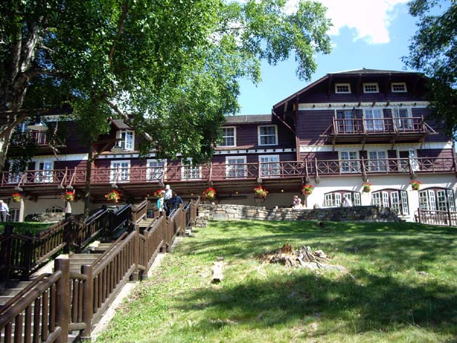
All the lodges in the national parks seem to be done differently, and they were constructed to be complementary to their environment. Certainly,
McDonald Lodge,
seen here from the lake shore in all of its beautiful detail, is an excellent example of what are called the "Great Lodges of the National Parks." The inside of the lodge was just as beautiful as the outside, as this picture of the
main lobby
of the lodge will attest. Note the log construction and use of natural materials, the hunting/fishing motif and especially the handmade shades for the hanging lamps, which were painted with small vignettes of the park and other Native American icons.
To get back to the SUV, we walked around the other side of the lodge. Here, there was a
footbridge over Snyder Creek
and another pretty view of the lake. We got back in the SUV and continued on the GSR heading northeast. Our next stop would be the area around McDonald Falls.
McDonald Falls Area
Leaving McDonald Lodge, we headed up the GSR just a short ways, and we came to a turnoff and parking area. There were some cars there, and some people had walked out to a wooden bridge that crossed McDonald Creek, approximately at the location of the red star on the map. We walked out onto the bridge and were rewarded with what we thought was
McDonald Falls.
Laboring under this misapprehension, I took a couple of movies of these falls. The first movie shows the falls and creek and gives you a great view of McDonald Creek. You can watch this one with the left-hand player below. Then, I climbed down from the wooden bridge where the first movie had been taken, walked up towards the actual falls a ways, and then did a close-up movie of the waterfall that you can watch with the right-hand player below. Finally, I got Fred to take a picture of
me and the falls.
<>
It wasn't until we got up the road a ways that we saw the signs for the actual McDonald Falls; the place where we have stopped this time is just some smaller, unnamed waterfalls/rapids on McDonald Creek, about a half-mile below the actual falls. These falls were pretty nice nevertheless and the stop was well worth the time.
Thinking we'd seen McDonald Falls, we got back in the SUV and headed up the GSR. We'd gone less than a mile before we saw some big signs pointing the way to
McDonald Falls
and we realized, as soon a we got out of the car and walked over to the
McDonald Falls Overlook
(the yellow star on the map), that what we thought had been McDonald Falls hadn't been. They were more like the "McDonald Cascades."
Once we got down to the wooden overlook, Fred got a picture of
McDonald Creek
while I worked on a movie of McDonald Falls. As usual, the movie does a better job of presenting McDonald Falls than any of the still shots do, and you can watch it using the player at left.
Just after I finished the movie, Fred got a picture of me and the
McDonald Falls crevasse.
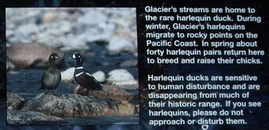
There was a sign on one of the platforms that talked about the volume of water flow through the creek at various times of the year. At this time, the flow is about half of what it is at the height of the spring snowmelt; in September, the creek slows almost to a trickle, the sign said. So I guess we were here at the right time- enough water to make the falls interesting but not so much that the rocks and the crevasse are overwhelmed. The sign also talked about Harlequin ducks, a variety that seems to be disappearing. It would have been nice to see one, but none were in evidence.
There were a number of walkways and overlooks and we walked here and there on them to try to get different vantage points from which to view
McDonald Creek,
and I took a last movie of the McDonald Creek rapids from here at the overlook, and you can watch it with the player below:
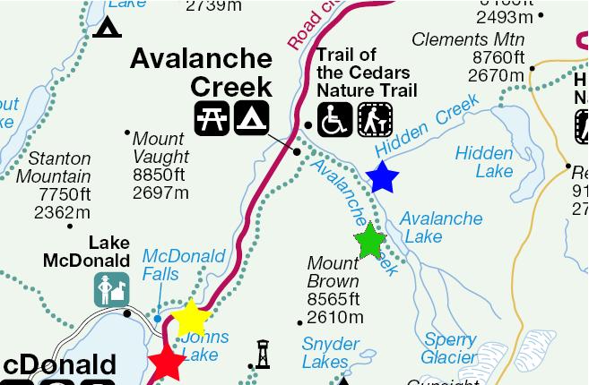
Our next stop was a couple of miles up the GSR- a couple of trails that take you to some waterfalls and then, way beyond them, into the mountains and up to some glaciers. We didn't have time for the hike all the way to the glacier, but we did take the
Trail of the Cedars,
a beautiful, shady trail leading through a large grove of Western Cedar trees and paralleling Avalanche Creek. You can watch a movie of the creek with the player at left. There were two stops that we wanted to make on this trail. The first was at the point where
Hidden Creek
empties into Avalanche Creek (at the blue star on the map). Hidden Creek is so named, we surmise, because here, at the point where it ends in Avalanche Creek, it is flowing through what the sign said is known as
Sun Gorge
which is deep enough to effectively hide it, unless you come at it from this direction. Were you hiking through the woods perpendicular to its flow, the
gorge
is so narrow that you could almost step across it.
The Trail of the Cedars continues on past Hidden Creek for a ways, and then there is a wooden bridge that allows a first, spectacular view of Avalance Creek cascading through Avalanche Gorge. You can watch a movie of this cascade using the player at right. The trail continued to follow Avalanche Creek as it flowed through the
shady gorge,
and there were a number of overlooks that offered close access to the creek and gorge. Here is
Fred at Avalanche Gorge.
As we walked along, I made a movie showing Avalanche Creek flowing through the gorge, a movie that you can watch with the player blow. As we neared the top of the gorge, Fred captured me at the point where Avalanche Creek
enters Avalanche Gorge.
Eventually, the Trail of the Cedars comes out at the "top" of Avalanche Gorge. From this point on, the trail climbs less steeply, we are told, and it continues to follow Avalanche Creek up into the back country towards Avalanche Lake (the green star on the map) and Sperry Glacier. You can see another movie of Avalanche Creek with the left-hand player below. Here is
Fred above Avalanche Gorge,
the point on the trail where we turned around.
I'd bet this would have been a wonderful trail to hike had we the time. It has two excellent qualities for a summer hike- it follows a stream and it winds through forest. We decided to put this hike on our list of things to do should we ever get back this way again. On the way back down, I couldn't resist one more movie featuring the restful sounds of Avalanche Creek and the Trail of the Cedars; you can watch it using the right-hand player below. Shortly, we were back at the SUV, and off again up the Going-to-the-Sun Road.
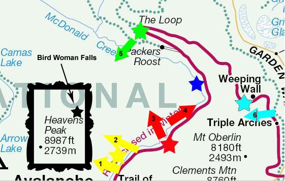
The GSR Loop Area
Leaving Avalanche Falls, we continued north along the Going-to-the-Sun Road through Glacier National Park. The landscape is, of course, spectacular, but it is even more so when what you have left behind is the hot, dry and currently very arid landscape of North Texas. As the road continued to rise, we got better and better views of the mountains and forests. As we reached the point marked by the yellow star on the map, we got some excellent views of
Heaven's Peak
off to the left (west) of the roadway (viewpoint #1 on the map). And just a short way further, a better view of
Bird Woman Falls,
one of the most famous and beautiful natural features in the park (viewpoint #2). One of the reasons that it is so famous (and photographed) is that it can be seen from quite a long distance along the GSR. Going east, this was the first time we could see it, but going west it can be seen just west of Logan Pass. Thus, it is almost always in view throughout the Loop Area of the GSR.
Continuing on along the GSR, we came to a
tunnel
over the roadway, at approximately the location of the red star on the map. The outer wall of the tunnel wasn't very thick- maybe fifteen feet or so- and so we were quizzical as to why the road hadn't been built to simply "hug" the outer wall of the mountainside. But when we walked into the tunnel, we found that there was a "window" cut through the tunnel wall so that you could look northwest and see the
McDonald Creek Valley
off towards the Loop (viewpoint #3). And once we reached the small wall built at the end of the window walkway, we found out why the road had been tunneled in the first place- the drop was a sheer one, even cutting back in a ways, down to the valley floor. There would have been nothing on which to put the road. Because there were natural "shelves" on either side of the tunnel, we imagined that at some point long ago, there had been either a landslide or there had been some natural fissure or crevasse. The tunnel was about 200 feet long, so reconstructing a "shelf" to put the road on would have been almost impossible.
We walked the rest of the way through the tunnel, and found something surprising on the other side. Watch a movie of what we found using the player at left. It seems obvious that the
tunnel waterfall
was either seasonal, or had not been there when the tunnel was built, since it would have been in the way of construction and possibly re-routed under the roadway. Whatever the reason, it was a really neat feature. Here is another picture of the waterfall, taken by Fred in his
artistic
mode.
At a point just beyond the tunnel, the road curved around the side of Mt. Oberlin, and the view towards the northeast opened up for a short ways, and we were able to see across a valley (from viewpoint #4) to what is called the
Garden Wall
formation. We knew there were a number of waterfalls over on that side of the valley, but they would have to wait for a while as we traveled around the Loop. But we didn't have to wait that long to encounter our next
waterfall
as we came upon this small roadside
step waterfall
about halfway between the tunnel and The Loop (at about the blue star on the map). This waterfall had obviously been here when the road was built, as there was a turnoff and a place where
Fred
or anyone else could sit and enjoy the falls.
But it was at the sharp turn in the GSR called "The Loop" where we encountered a
spectacular waterfall,
one of the most interesting we encountered on our entire trip. Right at the green star on the map, the road curves around the extreme upper end of the
valley
leading down to McDonald Creek, and begins its route along the opposite side- the Garden Wall. If you will use the movie player at left to take a look at the movie I made of the beautiful panorama here, I think you will get a better appreciation for just how interesting and beautiful these falls were. When you listen to the narrative, you will hear me describe these as Bird Woman Falls, but it was not until later that we found out that
Bird Woman Falls
(shown here taken in the direction of viewpoint #5) was across the valley near Heavens Peak. Since I am writing this narrative after the fact, the earlier views of Bird Woman Falls are correctly labeled, but the movie was taken in real time.
The movie was taken from the GSR before it makes its loop, so we are still a half mile from the
bridge
over the falls. While I had been concentrating on the falls themselves, Fred added an extra perspective when he took a picture of me and the
snowpack
above the falls. It is this snowmelt, of course, that provides the water for the falls. As with many of the water features in Glacier National Park, this one has much, much less water flowing through it later in the summer as the amount of snow left to melt decreases. By late August, the ranger had told us, many of the creeks and waterfalls are almost dry, so it looked as if we had come at just the right time. In this picture, incidentally, it is curious how Fred's flash makes it look as if I am standing indoors in front of a photograph. Before we headed on around the road through The Loop and across the bridge, I wanted to demonstrate the scale of the falls and bridge, so I waited to catch a
truck on the bridge
over the falls.
We were going east, now, on the GSR, following the Garden Wall formation. About two miles east of The Loop, we encountered what a bit later in the summer would have disappeared. Using the player at right, take a look at the movie of this temporary attraction. Looking closely at the snow tunnel, it was apparent that it was well on its way to collapsing entirely; my guess would be than in another week it would fall and be gone forever- unless the same thing happens next year when the water tunnels through new snowfall.
The last point of interest in the Loop area was the
Weeping Wall.
This waterfall is actually a 100-foot-long wall of rock that has a series of shower falls right beside the road (at the light blue star on the map). In fact, cars going in the other direction from us can't avoid getting wet (and while we were passing by, a young kid in an open Jeep made sure that his girlfriend got soaked).
As we headed eastward on the GSR, the slopes of Mt. Oberlin started to obscure the views of Bird Woman Falls, as the road must follow the Garden Wall ridge and go behind the mountain. So I took one final picture (at viewpoint #6) of
Bird Woman Falls
before it disappeared from view entirely, as we continued on our way eastward (and upward) to Logan Pass.
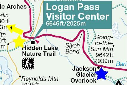
Logan Pass
With the Weeping Wall and Bird Woman Falls behind us, we began the long climb to the southeast to reach the highest point on the Going-to-the-Sun Road- Logan Pass. We climbed along the Garden Wall ridge steadily, and were now often in shadow. Snow began to appear by the roadside, and by the time we reached Logan Pass, there was quite a lot of it.
At Logan Pass, there was a parking area that was almost full. Here, at the highest point in the road, lots of people stop to walk out on the elevated walkways to get views of the
Garden Wall
back to the west. The photo (taken at viewpoint #1) doesn't really do the scene justice, and there are elements to the experience that pictures can never capture- such as the clean, crisp air, and the almost complete silence (if you filter out the people walking around).
Also here at Logan Pass, a few feet up the road from the parking area, was a beautiful small
waterfall
that came right over the crest of the ridge and then went both along the road, under the snow to the right, and under the road and out across a high meadow north of the road. There was still one more attraction here at Logan Pass- a family of mountain goats. I guess this is why so many people were parked here. The goats had been wandering around under the walkways, and people were trying to get pictures of them, but it was fortunate that when I was ready to take my own shots, the entire group had come out of the wooded area to lounge right at the side of the road. I got three good pictures. The first was of
mother and offspring,
the second was of the
male
in the group, and the last was of the second
young goat.
Oddly enough, the mountain goats seemed totally unconcerned with the small crowd of paparazzi taking pictures of them as if they were Brad and Angelina. I think it was also interesting to see them losing their heavy winter coats; at this altitude, it is just now getting appreciably warmer, and I would assume that in just another week or so the coats will be gone. I did recall seeing the goats forcing their way through the underbrush earlier, and now it seemed as if they might have been trying the hasten the shedding process by doing so.
Jackson Glacier
Our last stop of the day was at Jackson Glacier, just a mile or so down the road from Logan Pass. The visitor center for both Logan Pass and for the glacier itself is located here (blue star), but it was so late in the day that the center was closed. It was the only visitor center or museum on our entire trip that we would have wanted to visit but didn't find the time for. But the trail was open, and so we followed it out across the
snowfield
towards Jackson Glacier and the overlook. In winter, the trail is marked with poles, and with the right shoes would be easy to hike (depending on the depth of the snow). Later in the summer, the trail will also be easy as most of the snow on the lower slopes will melt revealing a paved path and stairs. But just when we were visiting, the trail was often covered with wet snow on which a number of people had already been walking. All of the
mountain scenery
was spectacular in the crisp, cold, clear mountain air. There was still quite a lot of snow; almost every shady spot was still filled with it. But a sign at the visitor center proclaimed that in just a couple of weeks, all the snow on the lower slopes, where we were, would be gone, and the ground would be beginning to dry out. For now, though, the trail was slippery and wet, and the going was a bit difficult.
We got a good ways up the mountain slope, but we could see way ahead of us where people who had been to the overlook were on their way back. Judging the distance, the speed at which we were making headway and the lateness of the day, we thought it best to only go about halfway up the slope. We probably could have made it to the overlook before sunset, but coming back in the fading light would hae been tricky because of the condition of the trail. Coming back down the trail, when we reached the point where most of the trail was clear of snow, I got an excellent picture of
Fred, the trail and the visitor center.
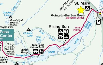
To the St. Mary Campground
By the time we got back to the SUV, it was getting to the point at which we needed to head on to the campground to ensure that we had plenty of light to set up the tent and cook dinner. So, using Glacier Overlook as our dividing line, we headed directly to the east portal of the Going-to-the-Sun Road and the St. Mary Campground. Tomorrow, we planned to drive back in this direction to visit all the points of interest between here and the campground. As it turned out, this plan worked quite well.
We reached the St. Mary campground (the yellow star) in plenty of time to retrieve our reserved site from the ranger, get the tent set up, have dinner and download all the pictures we'd taken. This was the first time we had reserved a campsite anywhere ahead of time; this one had been reserved two days earlier when we were on our way to Thermopolis, WY. The site we were assigned was a very good one, close but not too close to the facilities, close to a water source, and at the outside edge of the campground near St. Mary creek.
Today's Flora
There was only one picture in this category today-
a hanging basket at McDonald Lodge.
You can use the links below to continue to another photo album page.
|
July 5, 2006: A Day in Glacier NP, MT |
|
July 3, 2006: The Bighorn Wilderness, WY and Lost Creek SP, MT |
|
Return to Glacier National Park Trip Index |