July 6, 2006: Two Medicine in Glacier NP, MT and Great Falls, MT
July 4, 2006: Holland Falls and the Going-to-the Sun Road in Glacier NP, MT
Return to Glacier National Park Trip Index

 
Wednesday, July 5, 2006
A Day in Glacier National Park


Baring Falls


We awoke fairly early this morning after a great night's sleep. There is nothing like the soothing sound of water. Since we were camping again in the same place tonight, we didn't have to do what we usually do and take the tent down. All we had to do was just get washed up, have a bite of something to eat, and head off for a day of hiking and sightseeing. We were able to leave the tent up, and just close it to keep the animals and insects out. We've never really worried about belongings in non-commercial campgrounds like this one. The type of people who use them don't seem to be the same type of people who would help themselves to your belongings. Even so, we do take valuables and stuff with us- more because the tent might blow down than we think they might be stolen.


When we left the campground, we headed back west along the Going-to-the-Sun Road to catch the stops we'd missed the day before. Shortly after leaving the campground, the GSR begins to parallel Saint Mary Lake (viewpoint #1) for a ways. Saint Mary Lake has an intriguing little island, reminiscent of Wizard Island in Crater Lake. It was cloudy today, or our "mirror lake" shots would have been better. The GSR then climbs up a ways to where you can get good views of the rocky shoreline of the lake (viewpoint #2). We drove a few miles west on the GSR to arrive at the parking area for the trailhead for both Baring Falls and Sunrift Gorge. Both trails start from just below the stone bridge that carries the GSR over Baring Creek. As usual, I tried climbing around on the rocks alongside the creek at the trailhead.

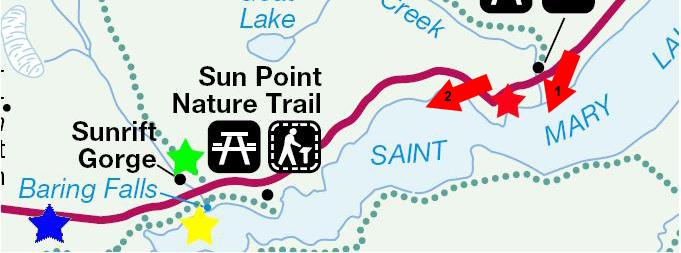
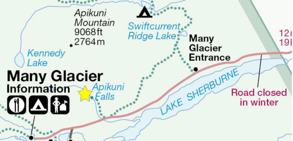
The trail down to Baring Falls (the yellow star on the map) leads to my right and down through the forest; the trail to Sunrift Gorge goes under the bridge and then up along the creek. We started out on the trail down to Baring Falls. The trail itself was very pleasant as it followed Baring Creek through the woods, and, along the way, we encountered one waterfall (look at this first one using the left-hand movie player below) after another (use the right-hand player for this second one).


After about a mile, we crossed a wooden bridge and arrived at Baring Falls, a small but beautiful waterfall nestled against the mountainside. The waterfall and pool were nestled in an enclosed area hemmed in by rocky cliffs on the one side, and the forest on the other. It was easy to climb over the rocks in the streambed and get right next to the cliff over which the falls cascaded. This was also an excellent place from which to take a movie of Baring Falls, and you can watch the movie using the player at left.

While I thought Fred was waiting for me, I found a route that went around and behind the rocky cliff behind me and then up on top for a different view of the falls. It was quite a scramble, but I like that sort of thing. When I got back down to the bridge, I found that Fred had headed off back up the trail (I'm not supposed to go off on my own without saying something), so I had to move quickly to catch up with him.

When we'd hiked back to the roadside trail head, we continued on under the bridge, and followed the creek up to Sunrift Gorge, at about the green star on the map, where the creek flows through the same kind of very narrow crevasse we'd seen near Avalanche Creek yesterday. We were able to follow the creek up a good ways until we got a view of the creek at the top of the crevasse.


We returned to the SUV and continued a bit further west along the GSR until we came to the Jackson Glacier trailhead. There are actually quite a few trails that end at or near Jackson Glacier, as it is one of the most famous (and most accessible) in the park. It would have been an interesting trail to take, but it would have taken us most of the day. There were lots of other things we wanted to do, so we settled for a good view of Jackson Glacier, from approximately the blue star on the map.

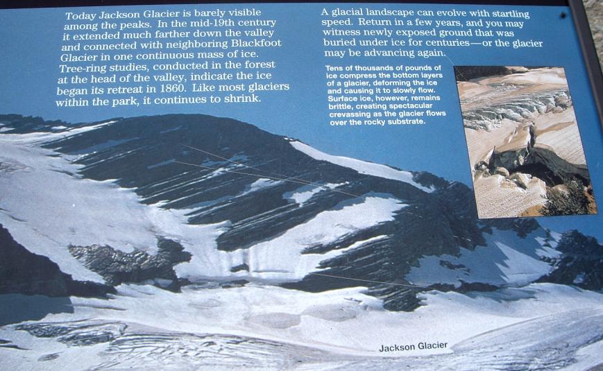
At the trailhead, there was this informative sign describing glaciers in general and Jackson Glacier in particular. The sign seems to acknowledge that the glacier may retreat substantially in the coming years or, if conditions change, may begin advancing again. But everyone we'd talked to at the ranger stations indicated to us that there has been less and less snowpack in recent years, and that the park's many glaciers have been growing steadily smaller. Whether this is all due to global warming or not remains to be seen, but it does seem a shame that the glaciers are not so magnificent as they apparently once were.


St. Mary Falls


Our next stop, just a few hundred yards west of the Baring Falls trailhead, was the trailhead for St Mary and Virginia Falls. We'd already researched these falls on the Internet, and had some good descriptions and directions. For example, we found on the Internet that there are actually three different sets of falls- St Mary, Virginia and, between them, Lower Virginia. Many people reach Lower Virginia Falls (the red star on the map below), think they've finished, and turn around. If there are other people on the trail, this tends not to happen, but in any event we were prepared.

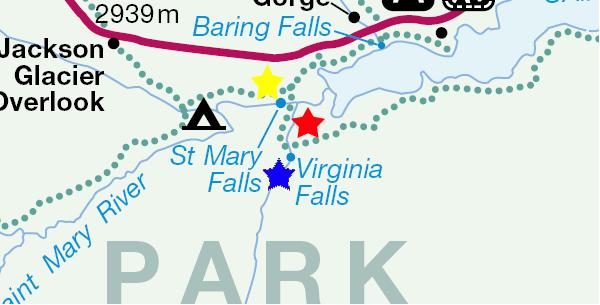
We set off from the trailhead across a small meadow, and then down into the forest toward the St. Mary River. As with all the other hikes on this cloudy day, the trail was cool and shady as it descended steadily. The trip to St. Mary Falls is something over a mile. At the falls, the trail crosses a bridge at the base of the falls- you can look up at them and the water flows down the falls and under the bridge beneath you.


Let the movie that I took from the bridge be your introduction to St. Mary Falls; watch it using the player at right. There are three levels to the falls; the upper and middle falls can be seen behind us, and the water from them pauses in the swirling pool that is right next to the bridge. As usual, I just have to go where I'm not supposed to go. But an even better way to see the falls is to climb up on them. I suppose it's not encouraged, but we certainly weren't the only folks who'd been up there. I think that the movie of St. Mary Falls that I took from the top of the falls will make you feel as if you were standing there with me. Watch it using the player below:


It's hard not to overdo the picture-taking when you reach such a spectacular natural wonder as St. Mary Falls. We certainly saw our share of waterfalls on this trip, and it seemed that they were all vying for most beautiful, but I really think that for a number of reasons (ease of access, beauty, sound and variety), St. Mary Falls were close to the top of the list. From my perch at the top of the falls, here is a view of the Upper Cascade and you can watch a movie of it using the left-hand player below. Here is a picture of the Middle Cascade and you can watch a movie of it using the right-hand player below:


Here is a view of Fred at the bridge, taken from my perch at the top of the falls, and a reverse view, taken by Fred down by the bridge, of me at the top of St. Mary Falls. Fred came up to join me (with a little coaxing, and once he saw some other people older than me up here), and I got a good picture of Fred atop St. Mary Falls. Of course, that is the St. Mary River in the background behind Fred, and it reaches the waterfall just a few feet behind him. Here's me atop the falls and here's the St. Mary River and me. And here is an excellent picture that Fred took of the bridge and lower falls. Fred came down off the falls one way (the easy way), and I chose a somewhat more difficult, possibly even prohibited path.


We lingered at St. Mary Falls for a while, and then continued up the trail to Lower Virginia Falls which are marked on the map by the red star. You can watch my first movie of them using the player below:


Lower Virginia Falls


Lower Virginia Falls

From what we read on the Internet, a lot of hikers get here and think they've reached Virginia Falls, but they haven't- although these are beautiful enough to make you think you're at the destination of the trail. Here are a couple of pictures of me- first, taking a picture from the top of the falls and then perched beside the upper cascade.

Lower Virginia Falls tumbles down over a pretty bare cliff face, but the cliff face is angled, so it was easy to work my way down the face of the falls to see the lower cascades in some detail and just enjoy the falls- as you can do if you use the player at left.

After a bit, I came back up to the trail at the top of Lower Virginia Falls, and you can see the top of the falls and some other hikers in the background. From the top of Lower Virginia Falls, here is the upper cascade and a view looking down the falls. We continued on up the trail, passing a small waterfall and a set of very pretty cascades on the way.

Just before you reach Virginia Falls, the creek tumbles down a small narrow waterfall. We almost missed this waterfall, it being just off the trail and down the hill, but we could hear it. A bit further on, just before the end of the trail, there is a log bridge over a rock fissure, but you really can't appreciate it unless you see it from below. So I climbed down the rock face at the upper end of the bridge and clambered out to the edge of the stream to take a picture of the bridge and the trail across it.

Then, in a minute or two, we were there. Virginia Falls (at the blue star on the map) is the tallest of the three sets of falls on this hike, and so pretty that each of us wanted to have a picture of ourselves with the falls as a backdrop. So, we switched off, and here are those pictures- first me at Virginia Falls and then Fred at Virginia Falls. When the trail reaches the falls (and it ends there), there is a log bridge that you can stand on for an excellent view of Virginia Falls. Virginia Falls throws off a lot of spray, since the water is in free fall rather than cascading down a rock face or through a channel, so unless you wanted to get really wet, it was impossible to get really close. I did work my way around a bit closer to photograph a side view of Virginia Falls.


St Marys Lake Panorama

At this point, we turned around to go back down the trail and headed off. Just below Virginia Falls, there was a narrow crevasse through which the creek flowed, and there was an earlier picture of it taken from below the cascade. Here is the same cascade taken from above. Also, as we were hiking back down the trail, we saw something we'd missed on the way up- a small trailside spring whose output was flowing over some interesting reddish rocks.

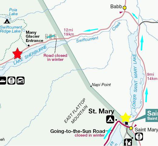
Our next stop was going to be Many Glacier, in the northern part of Glacier National Park. To get there, we have to leave the park at the east portal near the campground, head north for fifteen miles, and then come back into the park at the Many Glacier entrance. On our way back towards the campground and park entrance, we passed alongside St. Mary Lake and I was able to take a pretty good movie of St. Mary Lake that you can watch with the player at right.


The Trip to Many Glacier


After completing the St. Mary/Virginia Falls hike, we had done all the hikes that we missed the day before when we drove from Jackson Glacier and Logan Pass directly to the campsite. Next, we wanted to see the Many Glacier area and do some hiking there.


To get to this area of the park, it is necessary to leave the park temporarily, go north on a Montana road, and then re-enter the park at the Many Glacier entrance. So, the first thing we did was head back east along the Going-to-the-Sun road and exited the park after stopping briefly at the St. Mary Visitor Center (the yellow star on the map) to pick up some brochures and find out about some hikes in the Many Glacier area. Then, we left the park and headed north on US89 to Babb, Montana, and then west on the park entry road, through the Many Glacier entry and to a stop for lunch beside Lake Sherburne. Fred took a picture of me at Lake Sherburne (at the red star), which I include here to illustrate how, on cloudy days and with the use of a flash, people always seem to be posing in front of an indoor mural or photograph. The lake almost doesn't look real here. After lunch, we continued into the park for our activities at Many Glacier.


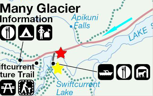
Many Glacier Hotel and Falls


Our first stop was at the Many Glacier Hotel, an historic hotel and the first one built in Glacier National Park. When the hotel was built, it was built in two sections connected by a breezeway. There is the main section and then this second building south of the main building, and both of them on the shores of Swiftcurrent Lake.

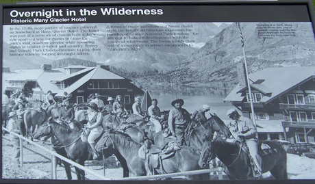
The hotel was part of a network of chalets built a day's ride apart in the park- a way for guests to cross the park's wild, roadless interior while spending nights in relative comfort and security. Two other chalets continue to play their historic roles by lodging overnight hikers. A blend of rustic materials and Swiss chalet style, the hotel's architecture expresses the paradox of Glacier NP tourism: the attempt to balance development with the forces of wilderness. The Swiss motifs grew out of a campaign to attract vacationers to "America's Alps." As seen here in this photo from the 1920s, large parties of tourists gathered on horseback at Many Glacier Hotel. After looking at this old photo, compare it to the way the hotel looks today, in this picture taken from the parking area. Can you pick out the buildings and pinpoint where, on the modern property, the old picture was taken?


Many Glaciers Lodge Panorama

We took a stroll through the hotel itself, and found it to be much like other lodges in the national parks- very rustic in design and decoration, but with as many modern conveniences as could be managed. Going through lobby one arrives on a broad, long balcony/deck that allows unobstructed views of Swiftcurrent Lake and the mountains beyond, and this was an excellent place to shoot a movie of the panorama of of the lodge and Swiftcurrent Lake. You can watch it with the movie player at right. We enjoyed walking through the hotel very much, and we decided (actually Fred decided to treat) to have dinner in the dining room once our hikes in this area were done. It was sprinkling around the hotel, but for our hikes later the weather was better.

Right where the short spur road leads from the park entry road to the hotel, there is a bridge over Swiftcurrent Creek, and just below the bridge are the amazingly beautiful Swiftcurrent Falls, and you can watch a movie of them using the player below:


Many Glaciers Falls Panorama


Swiftcurrent Falls

The first access to the falls is from an overlook positioned high above the final cascade, and so the movie you have just watched is looking up Swiftcurrent Creek towards the lake. From the same vantage point, here are the upper falls of Swiftcurrent Falls and also the middle cascades. In the center of the last scenes in the movie you can see a rock outcropping, which is approximately at the middle of the falls, and a trail led over to it. When I got there, I found that I had an entirely different perspective from which I could shoot another movie of Swiftcurrent Falls. You can watch this movie with the player at right.

Again from this same spot is a picture of the upper cascades at Swiftcurrent Falls. I continued along the trail to get a little closer to the falls, and was able to take another movie of the upper falls, which you can watch using the left-hand movie player below. Finally, I moved as close to the base of the upper falls as I could get to take one final movie of the upper cascades of Swiftcurrent Falls. Watch the movie using the right-hand player below.
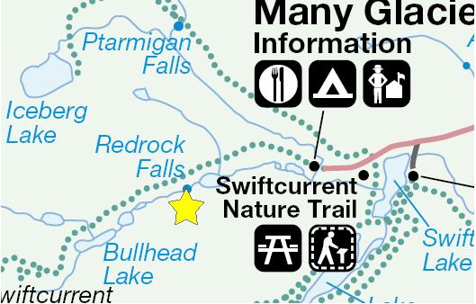
Upper Cascade at Swiftcurrent Falls
 
Upper Cascades, Swiftcurrent Falls


Redrock Falls


We had some choices next, the primary one being whether or not to hike to Ptarmigan Falls and the tunnels that we were told were also in the area. When we got some information about that hike at the information center, it turned out that the hike would be a long one, and not one that we could complete in time to have dinner at the hotel or do the hike to Apakuni Falls- which we really wanted to do. The information we got on the ice tunnels was conflicting- one ranger said they were really neat and another thought that other waterfalls in the area would be better. So we decided to do a somewhat shorter hike to a nearby waterfall instead.


The trailhead for the hike to Redrock Falls was at the end of the parking lot for the Many Glacier Information Center. We got our hiking stuff together (and I got my usual granola bar to eat on the way) and we started off down the trail (the dotted line on the map leading from the information center along Swiftcurrent Creek). Although the weather had been cloudy and cool earlier, the clouds had burned off and the temperature had risen so that conditions for hiking were pretty much ideal. After winding through the woods, the trail crossed a small stream via a log bridge. From that point, the mountain scenery just got better and better. The trail ran in and out of forest, often cutting across a mountain meadow or just providing us with one mountain view after another. At one point, we could see a really beautiful waterfall way off in the distance coming down the mountainside. Although this picture makes the waterfall seem very close, Fred took it on extreme zoom. There was no trail that we could see to that waterfall; had there been, we might well have taken a side trip to it.

Lake Near Red Rock Falls

After a couple of miles of walking, we came out on the shore of a small lake near Red Rock Falls, and I made a movie of the lake panorama that you can watch with the player at right. Looking across the lake we could get our first view of Redrock Falls, shown here on extreme zoom. The lake and mountains formed a wonderful backdrop for this first view of the falls.

For the next mile or so, the trail hugged the lake shore, and then we arrived at the first, lower cascade of Redrock Falls. Watch a movie of what we found using the player below:

Lower Red Rock Falls

Upper Red Rock Falls

When we reached the falls themselves, either the sound of the water or the spray made it certainly seem cooler. The falls were many-tiered, and so climbing on them was fun. We began at the base of the falls, right where the water from the stream runs into the lake. The lower cascade was quite pretty, and the mist from the water quickly cooled us off. Then we climbed about halfway up the rock face so that we could see the upper cascade of the falls close up. I made a movie here, and you can watch it with the player at right.

Fred had climbed up a bit higher so that he could take a picture of me and the upper falls. The water cascades over the upper falls into the pool at my feet, and then flows around behind me to the lower cascade and into the lake via a a short stretch of creek. Here is Fred with Redrock Falls as his backdrop, looking generally back towards the beginning of the trail.

Red Rock Falls Panorama

There was just about twenty feet more or so to the very top of the rocks here at Redrock Falls, and once we climbed up to the very top, we were surprised that there was more to these waterfalls than we had thought. Let me see if I can capture the whole panorama of Redrock Falls in a single movie; watch the result using the player at left.

About a hundred feet upriver from the falls, Swiftcurrent Creek, which continues on quite a ways from here into the backcountry of the park, falls a short distance into an upper pool (in which there were some people swimming, as it turned out). Next, the creek flows out of the upper pool and down to be blocked by the rock face formed by the fallen rock that long ago caused the waterfall to form. The rock face forces the water through a narrow channel and then it makes a right-angle turn to cascade down the many levels of Redrock Falls and finally into the continuation of Swiftcurrent Creek which carries it into the lake. From there, of course, it flows back generally along the trail until, having aggregated a good deal more water on the way, it cascades over the waterfalls right near the hotel.

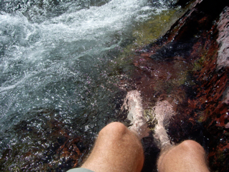
The hike had been quite warm, and the water looked so inviting, that I carefully climbed down the rock face to find a place where I could sit.

Ahhhhh.... Very refreshing!
Before we left Redrock Falls, Fred took a really beautiful picture of the mountains across the valley. As usual, we didn't really want to leave the falls, but there was more to see and do, so we began our trek back along the trail (following Swiftcurrent Creek for part of the way) until we arrived back to the parking lot. After a cold drink and a snack, it was on to our next hike.


Apikuni Falls


From the Many Glacier Information Center it is just a short drive back east along the park road, past Swiftcurrent Lake and Many Glacier Lodge and on to the Apikuni Falls trailhead. The hike to Apikuni Falls (marked with the yellow star on the map) was not terrifically arduous, although the height gain I would estimate as 500 feet or so in a relatively short time. Actually, the real bother was, for the first time on our trip- flies. Lots of them. Until we got above the brushline and near the falls, they were a constant nuisance.

Appakuni Falls

Our first view of Apikuni Falls was pretty surprising, as we turned a corner in the trail and there it was. Right at the point where we saw the falls for the first time, I took my first movie of Apikuni Falls to give you a good idea of what the area around the falls is like. You can watch this movie with the player at right. The trail led over closer to the falls, though, and I found that my going a little ways further along the trail I could take an even better movie of the falls, and you can watch it with the player below:

Appakuni Falls

The creek that forms the falls runs all the way down the canyon, and you can get close to the falls by climbing up the rocks that are spread through the middle of the creek to the pool at the base of the falls. Here is Fred and Lake Sherburne from the base of Apikuni Falls.

I couldn't actually climb on the falls themselves, but I could get good pictures from the rocky hillside across from them. So I started climbing up the hillside, leaving Fred down at the base of the falls. As I got higher, I could get better views of the valley and Lake Sherburne. From above the level of the pool, here is a good view of Apikuni Falls and of Fred still relaxing down by the creek. Here is an interesting view of the mountain on the opposite side of the creek.

I took two movies of Apikuni Falls from the rocky hillside. The first one was taken from about halfway up the hillside, and you can watch it with the left-hand player, below. The second one was taken from the highest point I reached, and you can watch it with the right-hand player, below:

Akapuni Falls from Above
 
Akapuni Falls

Once again, we could have stayed here for a really long time, but we still had dinner and the drive back to St. Mary Campground, so we reluctantly left Apikuni Falls and started on back down the trail (and through the flies) to the SUV.

We finished the hike about six in the evening, and so we went right back to Many Glacier Hotel for a good meal in the dining room. We had no problem getting a table and service was excellent. Fred had a buffalo stew on pasta and I had a whole trout. Both dishes were excellent, and not the least part of the meal was the volume of cold iced tea that we drank.

After dinner, we had some huckleberry soft serve ice cream in the basement sweet shop, then found a table where we could set up the laptop and download and review the day's pictures. Then it was back to the campsite for our second and last night in Glacier National Park.


Today's Flora

To see a full-size picture of any item, please click on the thumbnail:

(Click on Thumbnails to View)


You can use the links below to continue to another photo album page.


July 6, 2006: Two Medicine in Glacier NP, MT and Great Falls, MT
July 4, 2006: Holland Falls and the Going-to-the Sun Road in Glacier NP, MT
Return to Glacier National Park Trip Index