bas relief sculptures
on its base. We did not walk the length of the park, that would have taken far too much time. Instead, we headed across the
broad lawn
to Whitaker Street, intending to walk back north to the car.
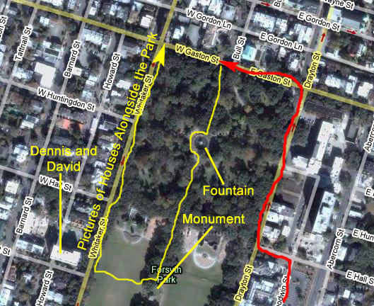
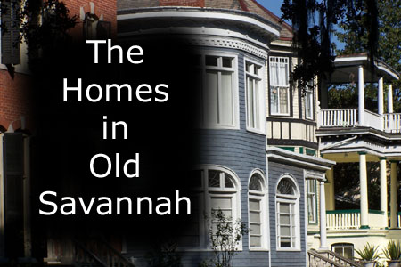
The Houses Alongside Forsyth Park
Crossing the lawn from Forsyth Park, we came to Whitaker Street. All of the streets bordering Forsyth Park are prime residential areas, primarily because of the killer views they all have. It must be like living along Lincoln Park in Chicago or Central Park in New York City. The walk all the way around the park is also a delight, and while we were walking along this section of it, lots of other folks passed us jogging, biking, walking their dogs or just strolling along in the shade.
On the other side of the park, along Drayton St., there are a number of boutique hotels sprinkled among the private homes, but on this side of the park the only structures that aren't private homes are a few bed and breakfasts and one or two apartment/condo buildings. The building immediately across Whitaker from the point where we crossed the park was actually the building where my friend, Dennis Haggard, was living with his partner David the last time I came to Savannah in 1983. So I had been here before, and walked along the same stretch of the park border that we traversed today.
|
Click on the Image Above to View the Slideshow |
It did seem to me, though, that there had been a lot of updating done; the houses looked nicer than I remember them. I expect there has been a great deal of gentrification as folks with money have purchased the old homes and redone them. That's mostly what we did in this stretch of our walk; we just looked at the houses and took pictures of those that we found interesting.
I've selected the best pictures of these homes and inns for inclusion in this album, and to make it easy for you to have a look at them I have created a short slideshow.
To view the slideshow, just click on the image at right and I will open the slideshow in a new window. In the slideshow, you can use the little arrows in the lower corners of each image to move from one to the next, and the index numbers in the upper left of each image will tell you where you are in the series. When you are finished looking at the pictures, just close the popup window.
Return to the Page Index
Walking Through Old Savannah
A Bit of Savannah History
So that you can understand a little more about the walking tour that we took of Savannah, I think it would be helpful if you had a bit of background about the way Savannah was laid out.
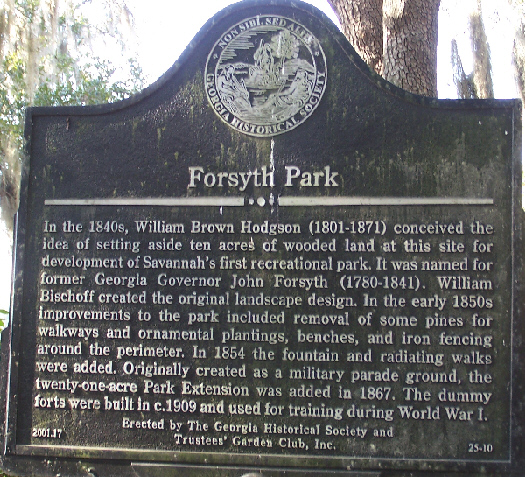
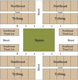
The City of Savannah was founded in 1733 by General James Oglethorpe. Although cherished by many today for their aesthetic beauty, the first squares were originally intended to provide colonists space for military exercises. The original plan resembles the layout of contemporary military camps which were likely quite familiar to General Oglethorpe. The layout was also a reaction against the cramped conditions that fueled the Great Fire of London in 1666. Oddly enough, the world city whose layout is most similar to Savannah's is...wait for it...wait for it...wait for it... Beijing! In Oglethorpe's layout, a square was established for each ward of the new city. The first four were Johnson, Wright, Ellis, and St. James (now Telfair) Squares, and themselves formed a larger square on the bluff overlooking the Savannah River. The original plan actually called for six squares, and as the city grew the grid of wards and squares was extended, so that twenty four squares were eventually created at the nodes of a six-by-five grid. (Two points on this grid were occupied by Colonial Park Cemetery, founded in 1750, and four others� in the southern corners of the downtown area� were never developed with squares.) When the city began to expand south of Gaston Street the grid of squares was abandoned, and Forsyth Park was allowed to serve as a single, centralized park for that area.
 |
 |
Layout of a typical ward
in Oglethorpe's plan |
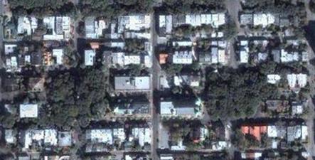
Modern aerial view of Monterrey and Calhoun Squares |
|
All of the squares measure approximately 200 feet from north to south, but they vary east to west from approximately 100 to 300 feet. Typically, each square is intersected north-south and east-west by wide, two-way streets. They are bounded to the west and east by the south- and north-bound lanes of the intersecting north-south street, and to the north and south by smaller one-way streets running east-to-west and west-to-east, respectively. As a result, traffic flows one way�counterclockwise�around the squares, which thus function much like traffic circles.
Each square sits (or, in some cases, sat) at the center of a ward, which often shares its name with its square. The lots to the east and west of the squares, flanking the major east-west axis, were considered �trust lots� in the original city plan and intended for large public buildings such as churches, schools, or markets. The remainder of the ward was divided into four areas, called tythings, each of which was further divided into ten residential lots. This arrangement is readily visible in the aerial photograph shown. The distinction between trust lot and residential lot has always been fluid. Some grand homes, such as the well-known Mercer House, stand on trust lots, while many of the residential lots have long hosted commercial properties.
All of the squares are a part of Savannah's historic district and fall within an area of less than one half square mile. The five squares along Bull Street� Monterey, Madison, Chippewa, Wright, and Johnson� were intended to be grand monument spaces and have been called Savannah's "Crown Jewels." Many of the other squares were designed more simply as commons or parks, although most serve as memorials as well.
Architect John Massengale has called Savannah's city plan "the most intelligent grid in America, perhaps the world," and Edmund Bacon wrote that "it remains as one of the finest diagrams for city organization and growth in existence." The American Society of Civil Engineers has honored Oglethorpe�s plan for Savannah as a National Historic Civil Engineering Landmark, and in 1994 the plan was nominated for inclusion in the UNESCO World Heritage List. The squares are a major point of interest for millions of tourists visiting Savannah each year, and they have been credited with stabilizing once-deteriorating neighborhoods and revitalizing Savannah's downtown commercial district.
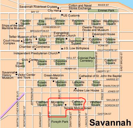
Our Route Throught the Savannah Squares
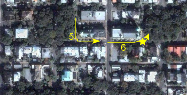
We won't have time today to walk through all the squares, although one day that might be a fun thing to do with someone who hasn't yet been here. I've outlined on the map of the Savannah Squares the area that we'll cover, and you can see that we will just be scratching the surface. I'm going to arrange the album pictures in sections, one for each section of our walk. In the description of our route, below, I'll number these sections, and then I'll use those same numbers in the sections of the album devoted to each "stop" on our tour.
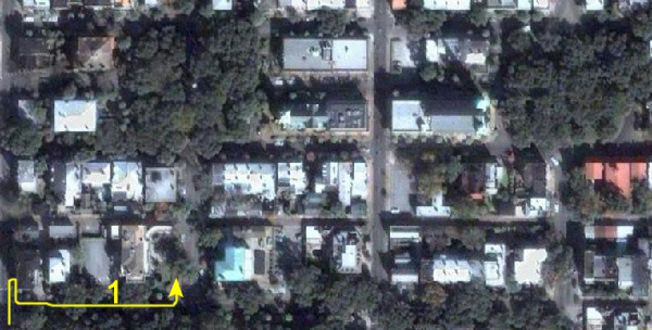
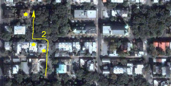
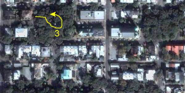
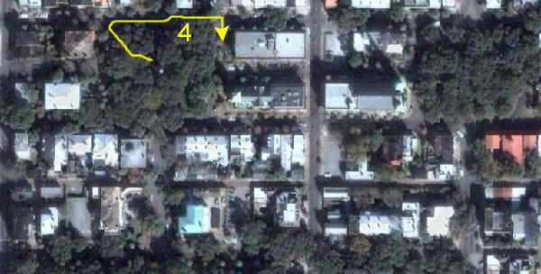
Our car is parked on the north side of Gaston Street, just west of Bull Street. Our tour will begin at the northwest corner of Forsyth Park at the corner of Whitaker and Gaston and continue along Gaston to where we parked (1). Next, we'll turn north on Bull and walk towards Gordon Street and Monterey Square (2). Of course, we'll explore Monterey Square (3), and then we'll walk along Taylor Street and the north side of the square (4). This will lead us around the square to Temple Mickve Israel (5), and then we'll walk east along Gordon towards Calhoun Square (6). Next, we'll explore Calhoun Square (7), and then turn back along Gordon towards Monterey Square again (8). We'll hang a left and head south on Bull, back towards the car, and the last section of the album will be the pictures taken in the area of Bull and Gaston (9).
Whitaker and Gaston (1)
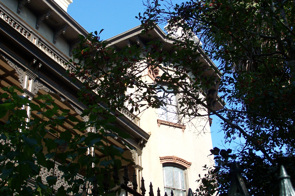
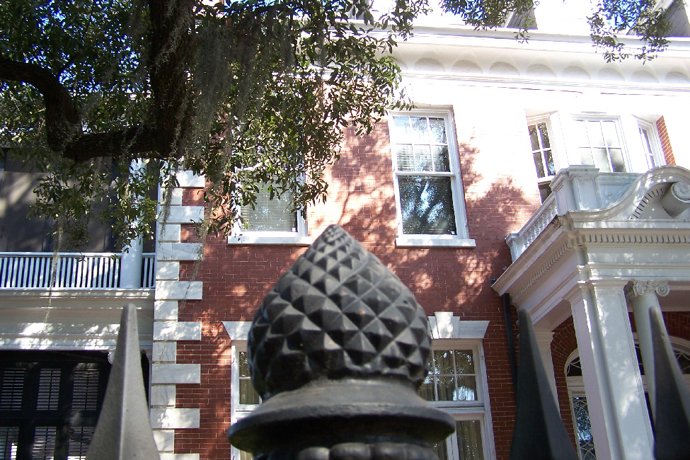
When we arrived back at the intersection of Whitaker and Gaston, we walked back towards where we'd parked the car. By this time of the morning, there were lots of tourists around going into the park, riding the tour buses and walking through the area. Right near where we parked the car, at the corner of Bull and Gaston, Fred ran across the first of many of the
old Savannah homes
that he found interesting. The
side of the home
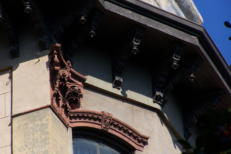
was along Bull Street, and the front faced Gaston. As he did throughout our walk this morning, Fred took a number of pictures of some of the detailing of the various houses and buildings we encountered, and here, on this house, he found the
window detail
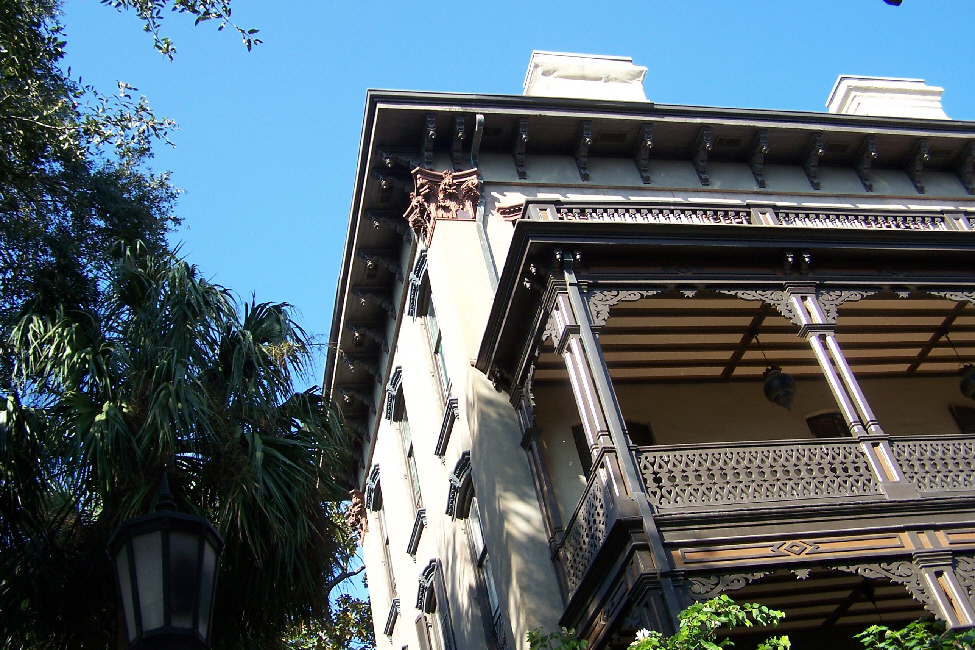
and
balcony detail
to be interesting.
Bull Street towards Monterey Square (2)
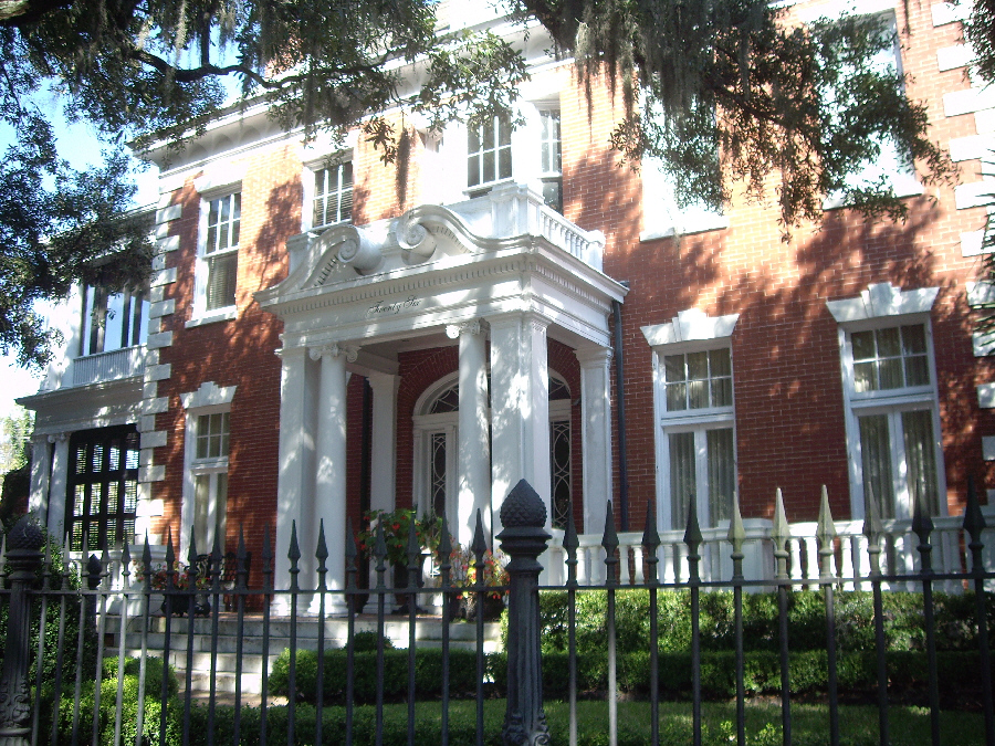
As we walked up Bull Street from Gaston towards Monterrey Square, we passed a wide variety of homes and businesses and a wide variety of architecture. One good example was this house, with what is reminiscent of
New Orleans architecture
with the extensive use of wrought iron that is so prevalent there. Because of the park just south of us, there were lots of folks walking through this part of Savannah.
When we reached Monterey Square, we first turned left and, a couple of houses down, found
a very familiar house;
as it turned out, this was the house used in the film version of the novel "Midnight in the Garden of Good and Evil" as the house where visiting writer John Cusack stayed while conducting interviews with Kevin Spacey's antiques-dealer character.
And as we turned north on the west side of the square (the southbound lane of Bull Street) and walked up to the northwest corner of the square, we came to the
Mercer House and Museum,
built originally by Hugh Mercer and then being the home of lyricist Johnny Mercer and most recently the home of antiques dealer and restorationist Jim Williams. The house, and the square itself, were featured prominently in John Berendt's 1994 true crime novel Midnight in the Garden of Good and Evil. The square has been used as a setting for several motion pictures, including the 1997 film version of the novel.
Exploring Monterey Square (3)
Monterey Square
was laid out in 1847 and commemorates the Battle of Monterrey (1846), in which American forces under General Zachary Taylor captured the city of Monterrey during the Mexican-American War. (The correct spelling in reference to the square is "Monterey," with a single r.) In the centre of the square is an
1852 monument
honoring
General Casimir Pulaski,
a Polish-born Revolutionary War hero who died of wounds received in the Siege of Savannah (1779). The cornerstone of the monument was laid by Lafayette�in Chippewa Square. Due to financial limitations an obelisk in Johnson Square served as a joint memorial to Nathanael Green and Pulaski for several years. By 1852 funds had been collected to give Pulaski his own monument. The sculptor was allowed to chose the site for the project and he had the cornerstone moved to Monterey Square.
Deterioration of the Pulaski monument was noted as early as 1912, and pieces began to fall in the 1990s.
Restoration of the monument
was completed in 2001. The body of an unknown Revolutionary soldier is said to be buried beneath Pulaski�s monument. Some have speculated that Pulaski himself is buried there, although he is generally believed to have been buried at sea.
We found Monterey Square, like the others we visited, to be a restful oasis in the middle of the neighborhood- exactly what Oglethorpe had intended. The wisdom of this plan seems so self-evident that it is hard to understand why it was not more widely adopted in subsequent housing developments across the country.
North Side of Monterey Square (4)
We left the interior of Monterey Square and walked over to the northwest corner of it, and then walked along Taylor Street along the north side of the square; crossing Bull Street again in the process. Along the way, Fred found a number of interesting architectural features to photograph.
One of them is the recurring feature that has the main entries for most of the houses not being at street level, but rather up a flight of stairs on the second level, as you can see here in this picture of a
typical house near Monterey Square.
My estimation would be that well over half of all the houses we saw had such entries; I confess I am not sure why.
At the northeast corner of the square, Fred found a
beautiful house
that seemed to be an excellent example of the southern colonial architecture. Particularly striking on this house was the extreme amount of effort that must have gone into the
detailed bay windows.
Along this part of the walk, Fred took a number of other pictures of note, and you might be interested in some of the things that he found photo-worthy. Just click on the thumbnails below to view the full-size images:
Congregation Mickve Israel (5)
Congregation Mickve Israel is the oldest Congregation now practicing Reform Judaism in the United States. Mickve Israel was founded by a group of Jews, mainly of Spanish-Portuguese extraction, which landed at Savannah July 11, 1733, five months after the establishment of the Colony of Georgia.
The Congregation was incorporated in perpetuity by a special Act of the Georgia Legislature on November 20, 1790. After having worshipped in various temporary quarters fo ralmost a century, in 1820 the Congregation built its own Synagogue- the first in Georgia- at the Northeast corner of Liberty and Whitaker Streets.
The present Synagogue
was consecrated on April 11, 1878.
In 1789, the Congregation received a letter from President George Washington which stated in part: "May the same wonder-working Deity who long since delivering the Hebrews from their Egyptian oppressors, planted them in the promised land, whose providential agency has lately been conspicuous in establishing these United States as an independent nation, still continue to water them with the dews of Heaven and to make the inhabitants of every denomination participate in the temporal and spiritual blessings of that people whose God is Jehovah."
Outside the Synagogue, Fred found one of the many
floral specimens
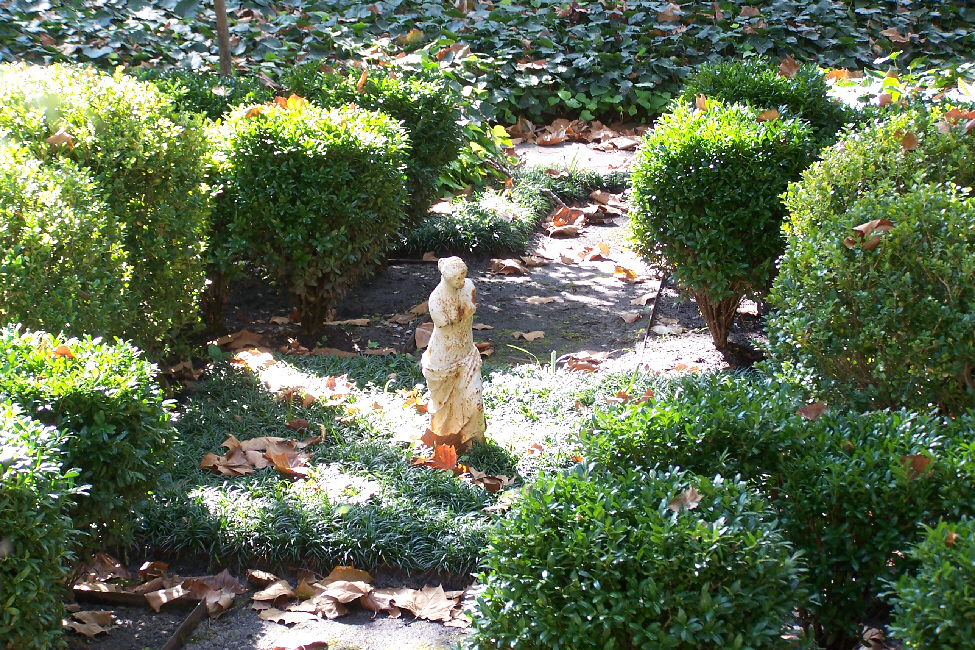
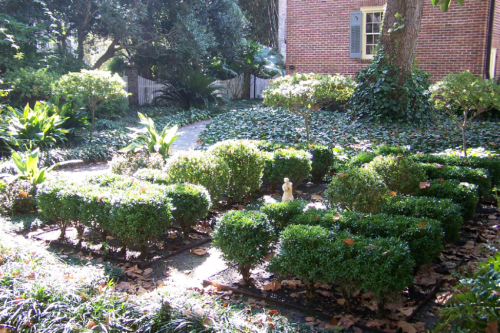
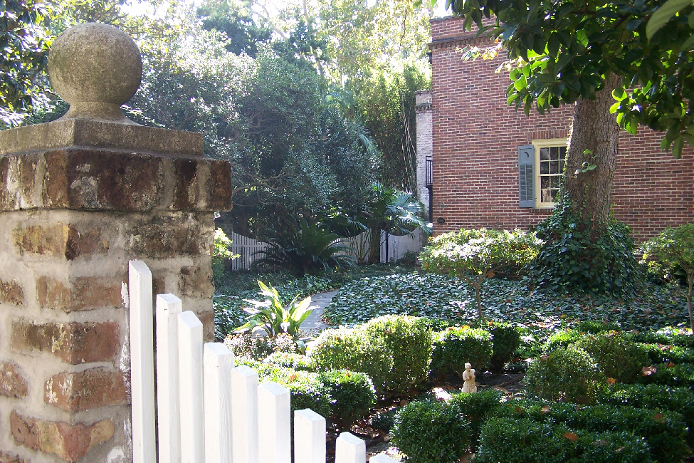
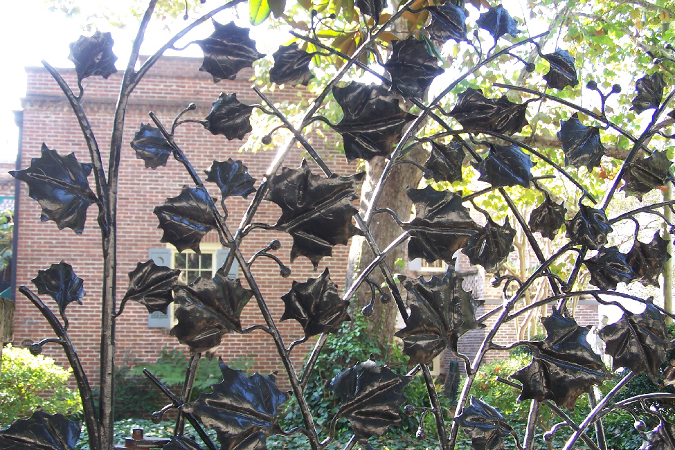
he encountered on our walk. The synagogue is at the corner of Gordon and Bull Streets, in the "southeast trust lot," as marked on Oglethorpe's plan. We walked around it and onto Gordon, heading east to Calhoun Square. On the other side of the street, Fred found an interesting sculpture and garden; it was interesting because the sculpture was so...well, why don't you click on each of the thumbnails below, going left to right, and you'll see what was so interesting.

The Sculpture |

Pulling Back |

The Garden |

Outside the Gate |
To Calhoun Square (6)
As we continued down Gordon Street (see map above) towards Calhoun Square, we were again struck by the lovely architecture of the homes along the street- and particularly the entries. One house had a
classic second‑level entry,
and then there was an entire
row of houses
whose entries were just a half-floor above the street, rather than a whole storey. And, as we walked, we could look back at the
domed spire of Congregation Mickve Israel
and ahead at the steeple of a
church on Calhoun Square.
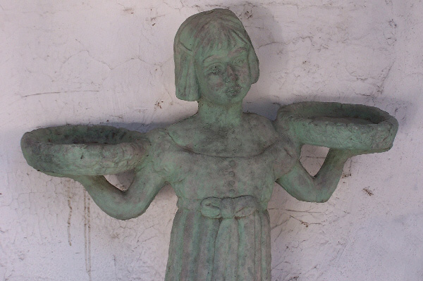
Just before we reached Calhoun Square, we came across a small antique store (star)- closed on this Sunday- that had, displayed out in front, the
statue of a girl
used in the film "Midnight in the Garden of Good and Evil." The actual statue is in a graveyard elsewhere in Savannah.
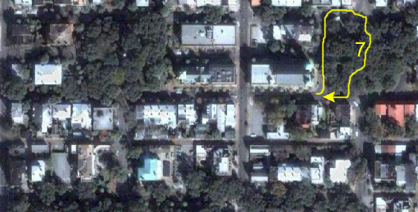
Exploring Calhoun Square (7)
Calhoun Square was laid out in 1851, one of the last squares created, and is named for South Carolina statesman John C. Calhoun, who served as Secretary of War, Secretary of State, and as Vice President under John Quincy Adams and Andrew Jackson. It is sometimes called Massie Square in reference to a neighborhood school. It is the only square with all of its original buildings intact, and is located on Abercorn, between Taylor and Gordon Streets.
We reached the square, and on our left was, if I remember correctly,
a Baptist Church,
the name of which escapes me. It was a beautiful church, however, and it looked out onto peaceful
Calhoun Square.
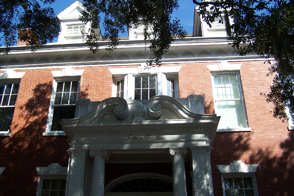
As we walked through and around the square, we saw more examples of the lovely Savannah architecture; this much certainly have been a city of "grace and beauty" for most of its history- certainly the period when these houses were built or restored. I especially liked the
graceful dual stairways
that led to the second-level entries for many of the houses. Most houses, too, had some sort of balcony or
sitting porch
on the third level, and I can easily imagine the residents sitting out on warm days, exchanging pleasantries with passers-by while sipping a cool drink.
In addition to the architectural styles and features of many of the houses, Fred was also quite interested in the ornamentation that graced many of those structures. Many houses had carvings and bas relief work on what would otherwise have been bare walls or columns, and he took a number of photos of these artistic touches. You can see a couple of good examples
here
and
here.
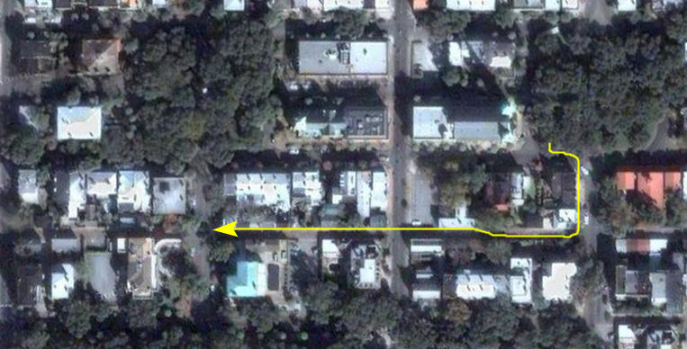
Gordon Street towards Monterey Square (8)
We only wanted to visit a representative couple of squares this morning; to try to cover them all would have taken far more time than we had. So we left Calhoun Square, went a block south and then headed back west along
Gordon Street
heading back towards Bull Street and Monterey Square. As we walked along, there were more examples of interesting architecture and ornamentation. One home had a really pretty
entry porch,
and another had some really well-maintained
gas lamps
by another nice entryway.
It appeared that at least one house was either occupied by someone who wasn't particularly concerned with horticultural maintenance or not occupied at all, for
it's front steps
seemed to be getting quite overgrown. (Of course, I let the same thing happen to my patio.) One house had what Fred found to be a very interesting
ornamented post
by its small garden.
We got down towards Bull Street eventually. Here is a view
looking back along the street
towards Calhoun Square. Down near Bull Street, I crossed over to get a picture of some more
modern row houses
that were interesting because of the different colored doors all in a row up on the second level. I could also get a picture of
Fred on the other side of the street,
before he joined me and we walked on to the intersection with Bull Street.
When we got to Bull Street, we came face on to another beautiful home. Fred took a couple of pictures of this house; click on the thumbnails below to see the full-size images:
Back to the Car at Bull and Gaston (9)
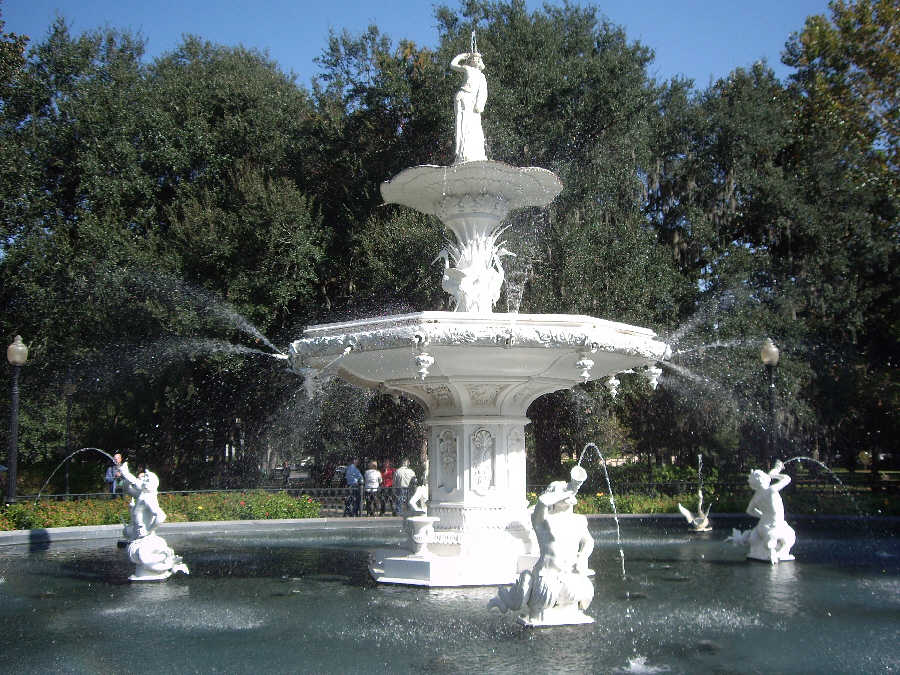
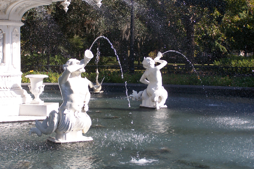
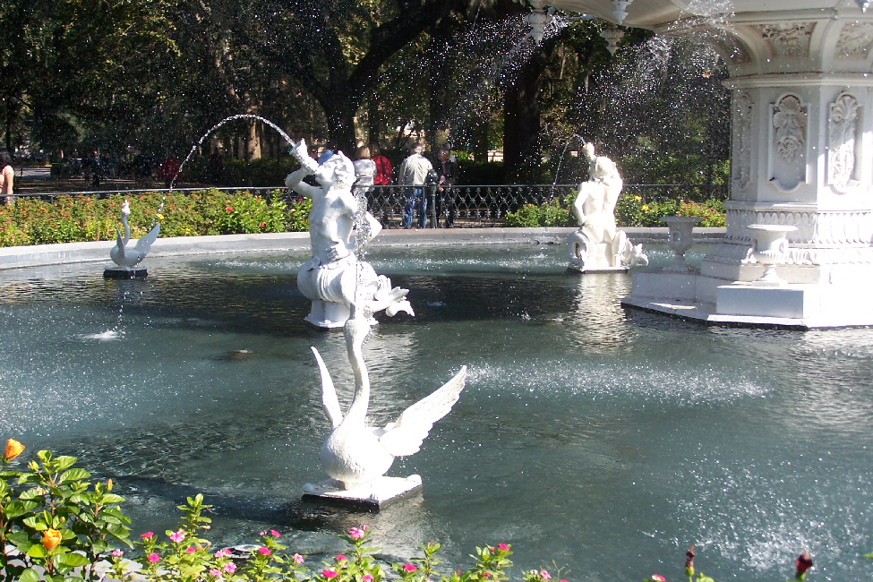
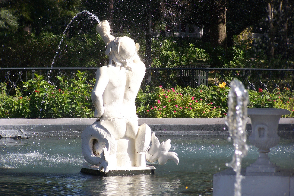
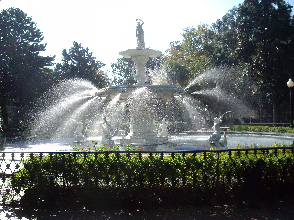
Well, we've arrived back at the corner of Bull Street and Gaston Street, right beside Forsyth Park. From this point, of course, you can get an excellent view right into the park to the
Memorial Fountain.
This corner was also interesting for the buildings that occupied the two corners north of the park. On the west side of Bull Street (the corner you can see in the picture at left) sits the former site of
Armstrong Junior College.
As you can read from the sign, the junior college used to be in the mansion behind it, although it is now elsewhere in Savannah. However,
the mansion
has received new fame since the college moved. It was taken over as the offices for Bouhan, Williams and Levy- a small but prestigious Savannah law firm. Perhaps because the building was already set up as a law office, it was used in the filming of "Midnight in the Garden of Good and Evil" as the offices of the law firm handling Kevin Spacey's art dealer character's legal firm.
On the other corner, on the east side of Bull Street, stands the former home of Confederate General Henry R. Jackson, purchased by him in 1889. There is a
commemorative sign
in front of the home that explains its history. As you can read on the sign, the house was used as the temporary headquarters of the Union Army at the end of the Civil War, and only later purchased by Jackson. Here is an excellent picture that Fred took of the
Jackson home.
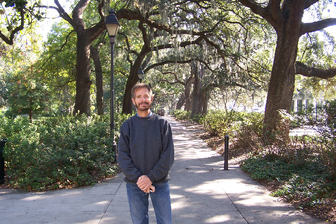
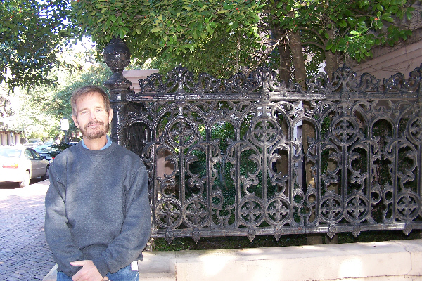
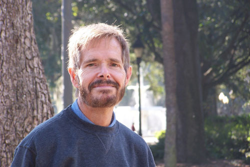
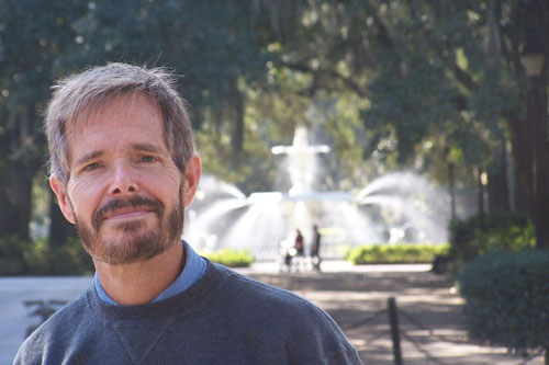
The last two pictures we have that belong here are a couple that Fred took of yours truly back here just outside Forsyth Park:
It's getting on towards noon, so it's time to go find a place where we can get a bite of lunch.
Return to the Page Index
Lunch and the Savannah River Walk
I recalled that when I was here visiting Dennis Haggard when he first moved to Savannah we found a lot of places to eat down by the river, so we got in the car and headed over that way.
For scenery, we went over to Barnard Street so that we would intersect and go around Pulaski, Orleans and Telfair Squares on our way down to Broughton Street- the main street through downtown Savannah. We went just a block or two east to pick up Bull Street again, and then went one block further north looking for a place to park. We found one easily enough, on Congress Street next to Johnson Square.
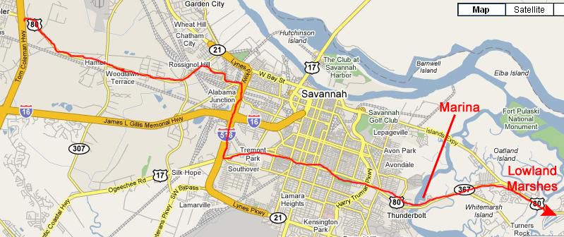
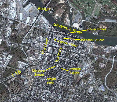
Before I talk about our lunch and then our walk along the Savannah River, I think it would be a good idea to orient you to all the things we did here in downtown Savannah. At the left you can see an aerial view of downtown. I've marked it with the stops of interest and also marked some of the streets and highways that I will be referring to in the narrative below. This aerial view should give you a good idea of the ground we covered while here in Savannah.
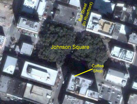
Lunch at Johnson Square
We found a nice little coffee shop right at the corner of Bull and Congress, so we stopped in there where
Fred had a sandwich.
I wasn't particularly hungry, so
I sat with him
and drank some iced tea. It was a nice, relaxing lunch after our walking tour.
From our table in the coffee house we could look out on Johnson Square, and as soon as we finished lunch we went across the street to explore it. Johnson Square was the first of Savannah's squares and remains the largest of the twenty four. It was named for Robert Johnson, colonial governor of South Carolina and a friend of General Oglethorpe. Interred in the square is Revolutionary War hero
General Nathanael Greene,
the namesake of nearby Greene Square. Greene died in 1786 and was buried in Savannah's Colonial Park Cemetery. His son, George Washington Greene, was buried beside him after drowning in the Savannah River in 1793. Following vandalism of the cemetery by occupying Union forces during the Civil War the location of Greene�s burial was lost. After the remains were re-identified Greene and his son were moved to Johnson Square. An
obelisk
in the centre of the square now serves as a memorial to Gen. Greene. The cornerstone of the monument was laid by Lafayette in 1825. At that time the obelisk did not yet commemorate any specific individual or event. In fact, due to financial restrictions the unmarked obelisk served for several years as a joint monument to both Greene and Casimir Pulaski.
Inscriptions honoring Greene
were added in 1886, but the Greenes� physical remains did not arrive until 1901, following their "rediscovery."
Johnson Square contains
two fountains,
as well as a sundial dedicated to Colonel William Bull, the namesake of Savannah's Bull Street. Bull was a South Carolinian who assisted Oglethorpe with the establishment of Savannah and, as a surveyor, laid out the original street grid. The square isn't devoted entirely to Greene, though. Off to one side is
a bench
commemorating Savannah native Johnny Mercer- lyricist and songwriter.
Over at the other side of the square is a
historical marker
commemorating President Washington's visit to the city in 1791. If you read the marker, you'll note that Washington attended services at the original Christ Church that stood next to the square. That building still exists, but the Church has been expanded and new buildings dating to the mid-nineteenth century now stand on that site. If you would like to see the church and read a bit more about it, take a look at the
Christ Church marker
that sits on the square near the church itself.
I might point out that we had been wandering around the square for quite some time before we noticed that
we were being watched.
Visiting River Street
Getting down to River Street from Johnson Square was easy; I remembered the way from my last visit to the street almost 25 years ago (when Dennis Haggard and I came down here shortly after he moved from Chicago to Savannah).
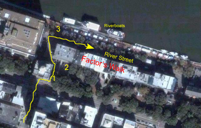
We walked across to the north side of Johnson Square and followed Bull Street one block to Bay Street. Just across Bay Street, and just to the right of City Hall, are one of the sets of
access stairs
that lead down to the riverside complex (1).
There are actually two streets below the stairs- both of them cobblestone streets. The first street leads between the buildings of the
Cotton and Naval Stores Exchange
(2). River Street itself is on the other (river) side of the exchange buildings, and is reached by a short walkway.
The
Savannah Waterfront
has a history dating back to the founding of the Georgia colony in 1733. The buildings along River Street that you can see
behind me
date from the early 1800s. They held warehouses for cotton and other products produced in the Southern states before, during, and after the Civil War. In fact, the buildings continued to be used for their original purpose for the next 125 years, with the last cotton office closing in 1956.
Today, River Street has been restored, and is now a street of tourist-oriented shops and restaurants. A bit west from where we came out onto the street there are some new hotels that bring more people to the area. Between the old cotton offices and the river itself there is a
riverfront park
that offers ample opportunities for walks and relaxation. On the dock that extends all along the riverfront there are a number of
riverboats,
which I presume are simply for tourist use.
Upriver from downtown Savannah, there is a
beautiful bridge
that leads across the river into South Carolina and up the coast to Charleston. (This picture was taken at point #3 on the aerial view above.) I took a
closeup of the bridge
so you could see how intricate and graceful it was. Fred, of course, has a much better zoom, and you may be interested in the extreme closeup picture that he took of the bridge, and you can see that picture
here.
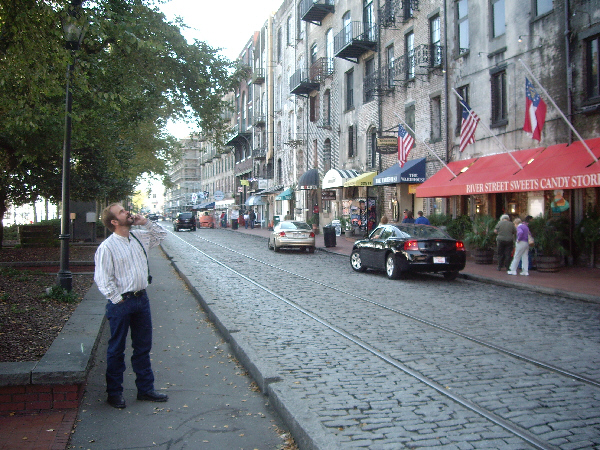
As I did many years ago, I stopped into the River Street Sweets Candy Store for some of the wonderful pralines that I remember they made here. I took some home to Chicago many years ago, and I plan to take some home to Dallas this time. Here I am,
waiting to get my pralines.
When I came out of the candy store, we headed back to the stairway up, but before we left River Street, I took a movie that tries to show all of what we had seen. You can watch that movie using the player at left.
We walked back up through Johnson Square to the car, and then turned to head a bit west on
Broughton Street
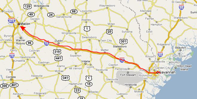
towards Martin Luther King Street and our access to Interstate 16 towards Macon and our last stop on this trip.
Return to the Page Index
Driving to Macon, GA
Our trip to Macon was relaxing. After walking around Savannah so much, it was pleasant just to sit in the car and watch the scenery go by. For the most part, the scenery along the interstate consisted of rolling hills and
pine forests,
as this picture taken near the midpoint of our run to Macon indicates.
On our drives, we have, of course, seen many cars pulling trailers of one kind or another, and we've seen many cars with bike carriers on the back. But
this car
had a rear bumper attachment we'd never seen before. I guess you've got to put 'em somewhere.
After passing this car, we did see a number of other pickup trucks carrying the same cargo, so the hunting must have been good this weekend.
Return to the Page Index
Touring the Ocmulgee National Monument
Getting to the Ocmulgee National Monument
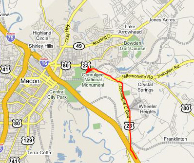
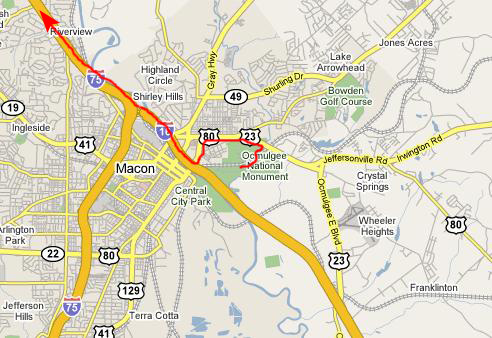
Our last stop of this vacation trip was going to be the Ocmulgee National Monument in southeast Macon. Getting there was pretty easy, as there was a marked exit to the north off I-16, and signs that led us right around to the entrance to the National Monument.
As you can see, all we had to do was turn off US 80 into the Monument and follow the park road to the Visitor Center.
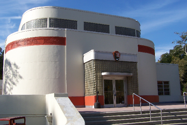
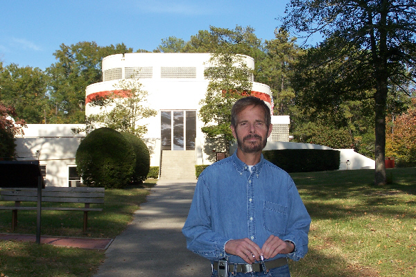
The Ocmulgee National Monument Visitor Center
Our first stop was, of course, the Visitor Center for the National Monument. The center was unlike many we had seen; it was done not in a rustic style, but rather in more of a 1930s Art Deco style. Here is another picture of
Fred at the Visitor Center.
Inside, we signed in and stopped in the little shop where I found a couple of books of ledger art; one will be for Fred for Christmas, and the other I will hold back for a year to give to Greg next year (Greg has often expressed an interest in ledger art). There were lots of exhibits and stuff to look at inside, and we spent the better part of half an hour doing that. There were artifacts collected from the various mounds as well as pictures taken when the mounds were first being explored and then set aside as a National Monument.
Fred took quite a few pictures of the exhibits inside the Visitor Center. Some turned out well, and some didn't. I've put thumbnails for the best of these pictures below; click on each thumbnail to view the full-size picture:
|
(Click on Thumbnails to View) |
History of the Ocmulgee National Monument and Surrounding Area
We learned a lot about the Ocmulgee mounds while we were in the Visitor Center, and I think it might be a good idea to depart from my usual "one thing after another" narrative, and instead key our visits to the various sites in the complex to some information that we obtained in the Visitor Center.
First, let's set the stage by recapping the history of the site up to the point where the first of the mounds that we visited were constructed.


The Paleo Indian Period (pre-9,000 BC)
During this period, Ice Age hunters arrive in the Southeast, leaving one of their distinctive "Clovis" spear points on the Macon Plateau (in the 1930's this became the first such artifact found in situ in the southern U.S.).
The Transitional Period (9,000 to 8,000 BC)
In this period, people adjust to gradually warming weather as the glaciers melt and many Ice Age mammals become extinct.
The Archaic Period (8,000 to 1,000 BC)
The Archaie Period saw efficient hunting/gathering, an adaptation to a climate much like today, and the use of the atlatl (spear thrower), woodworking tools, etc. White-tail deer become a staple and there are extensive shell mounds along the coast and some inland rivers. Approximately 2,500 BC, the first pottery in this country appears along the Georgia/South Carolina coast and soon filters into what is now Middle Georgia; it is tempered or strengthened with plant fibers which burn out during firing, giving a worm-hole appearance to the vessel surface.
The Woodland Period (1,000 BC to 900 AD)
This period sees pottery tempered with sand and grit, sometimes decorated with elaborate designs incised, punctated or stamped into its surface before firing. There is also cultivation of sunflowers, gourds, and several other plants, the construction of semi-permanent villages, stone effigy mounds and earthen burial and platform mounds and connections to the Adena/Hopewell Cultures farther North and to Weeden Island in Florida and South Georgia.
The Early Mississippian Period (900 to 1150 AD)
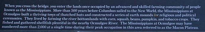
At this time, a new way of life, believed to have originated in the Mississippi River area, appears on the Macon Plateau. These people, whose pottery is different from that made by the Woodland cultures in the area, construct a large ceremonial center with huge earthen temple, burial and domiciliary mounds and earthlodges, which serve as formal council chambers. Their economy is supported by agriculture, with corn, beans, squash and other crops planted in the rich river floodplain. The indigenous Woodland people in surrounding areas interact with these people, who possess early symbols and artifacts associated with the Southeastern Ceremonial Complex (Southern Cult).
The Mature Mississippian Period (1150 to 1350)
The great Macon Plateau town declines and the Lamar and Stubbs Mounds and Villages appear just downstream. These towns are a combination of the old Woodland culture and Mississippian ideas. The Southern Cult, distinguished by flamboyant artistic motifs and specialized artifacts, flourishes at places like Roods Landing and Etowah (GA), Moundville (AL), Hiwasee Island (TN), Cahokia (IL), and Spiro (OK).
The Late Mississippian Period (Protohistoric) (1350 to 1650)
The Lamar Culture, named for the Lamar Mounds and Village Unit of Ocmulgee National Monument, becomes widespread in the Southeast. The chiefdoms are marked by smaller, more numerous, often stockaded villages with a ceremonial center marked by one or two mounds and a combination of the both Woodland and Mississippian elements.
The chroniclers of Hernando DeSoto's expedition into the interior of North America write the first descriptions of the Lamar and related cultures, ancestors of the historic Creek (Muscogean), Cherokee (Iroquoian), Yuchi (Euchee), and other Southeastern peoples. Most of their main towns are situated near rich river bottomland fields of corn, beans and squash. Many towns feature open plazas and earthen temple mounds. Public buildings and homes are constructed of upright logs, interwoven with vines or cane and plastered with clay (wattle and daub). Some are elaborately decorated and contain large woodcarvings. The DeSoto expedition�s 600 men and 300 horses devastate local food supplies; epidemics of European diseases decimate many populations.
In 1565, the Spanish establish their first permanent settlement at St. Augustine, set up outposts at towns along the Atlantic coast to the North, and begin to missionize the Indians. Priests and soldiers travel up the river systems to other towns in the interior of the area which would become Georgia.
The Modern Period
In the late 1600s, many Native Americans of the South moved to be near the British trading post at the site where the Monument is now. Together, these towns were known as the Ochese Creek Nation, or simply the "Creeks." Somewhat later, the Georgia Colony was formed on lands along the banks of the Savannah River given to General James Oglethorpe by Chief Tomochichi of the Yamacraws, a group related to the Lower Creeks. In 1739, Oglethorpe, met with the Creeks, and he and his Rangers were the first Europeans to explore and write about the mounds and lodges. But a more extensive description can be found in the 1774 journal of William Bartram, reknowned naturalist and botanist, who traveled through the area. He wrote: "On the heights of these low grounds are yet visible monuments, or traces, of an ancient town, such as artificial mounts or terraces, squares and banks, encircling considerable areas. Their old fields and planting land extend up and down the river, fifteen or twenty miles from this site. If we are to give credit to the account the Creeks give of themselves, this place is remarkable for being the first town or settlement, when they sat down (as they term it) or established themselves, after their emigration from the west..."
From the end of the Revolutionary War to the late 1830s, the relationships between the European (now American) settlers and the Native Americans paralleled those that would later characterize the "Indian Problem" in the American West. As the American population grew, the Creeks found it harder and harder to hold onto their ancestral lands, which included the rich river bottomlands that enabled the Creek Indians to take advantage of the cotton-based economy. In the first Treaty of Washington (1805), the Creeks were forced to cede much of the land between the Oconee and Ocmulgee Rivers, excluding a 3x5-mile strip known as the Old Ocmulgee Fields Reserve at present Macon, which the Muscogee (Creek) people refused to give up. As a result of this treaty, a "Federal Road" was built across remaining Creek lands, eventually stretching from Washington, D.C. to New Orleans.
As a reaction to the continued pressure from expanding American settlements, the Shawnee Chief Tecumseh traveled up and down the frontier exhorting the Indians to discard their plows, whiskey and the white man�s ways. Many Creeks joined his movement, but many did not, seeing economic advantage to their continued cooperation with the settlers. Conflict between these factions weakened the Crreeks, and they were again forced to cede more land- this time the lands between the Ocmulgee River and the Flint River (1821). Many settlers and government officials began to think about a total removal of the Creeks from their ancestral lands.
In 1823, the City of Macon was laid out and, finally, in 1825, the Treaty of Indian Springs ceded the last Creek lands in Georgia; the treaty being signed by Chief William McIntosh, who was later assassinated by his own people. Three years later, the second Treaty of Washington officially surrendered the last Creek lands in Georgia. The Indians themselves left the area- somme to join the Seminole in Florida, and others moving west into Alabama. About 1,300 resettled to what is now the state of Oklahoma, on lands given to them under the government�s voluntary removal program.
Shortly afterward, the Old Ocmulgee Fields Reserve, including the mounds, was surveyed and laid off into land lots incorporated into the city of Macon, and part of the Old Fields became a manufacturing site. Of the mound area, the local newspaper reported that "the site is romantic in the extreme; that, with the burial mounds adjacent, have long been favorite haunts of our village beaux and belles, and objects of curiosity to strangers. We should regret to see these monuments of antiquity and of our history levelled by the sordid plow - - we could wish that they might always remain as present, sacred to solitude, to reflection and inspiration."
The final conflict was the Creek War of 1836, after which about 2,500 people, including several hundred warriors in chains, were marched on foot to Montgomery, AL, and crowded onto barges during the extreme heat of July. They were forcibly removed to the Indian Territory. During the summer and winter of 1836-early 1837, over 14,000 Creeks made the three-month journey to Oklahoma- an repetition of the Cherokee "Trail of Tears." The sad relationship between the old and the new thus ended.
Macon development continued, and a new railroad was laid through the Ocmulgee Old Fields destroying a portion of the Lesser Temple Mound and the great prehistoric town. A locomotive "roundhouse" was built near the Funeral Mound. Eventually, much of the Macon Plateau site became part of the Dunlap Plantation. Clay for brick manufacturing was mined near the Great Temple Mound and a fertilizer factor was constructed nearby.
During the Civil War, a critical railroad bridge within the boundary of what is now the National Monument made Macon a linchpin of Southern Defense. Much fighting occurred in and around the current Monument, ending with the surrender of the Union General George Stoneman, who became the highest ranking Union officer taken prisoner during the Civil War.
After the War, in 1874, a second huge cut for a railroad was excavated through the mound area and destroyed a large portion of the Funeral Mound. According to Charles C. Jones, in his book, "Antiquities of the Southern Indians," many relics and human burials were removed during this work. The obliteration of the mound area continued over the years until a turning point was reached in 1933. By this time, a large portion of McDougal Mound had been removed to use as fill dirt for Main Street and motorcycle hill-climbing had left scars on the slopes and summit of the Great Temple Mound. A group of local citizens were convinced that the mounds were of great historical significance and should be preserved; these citizens sought assistance from the Smithsonian Institution, which sent Dr. Arthur Kelly to organize and conduct archeological excavations on the Macon Plateau.
 |
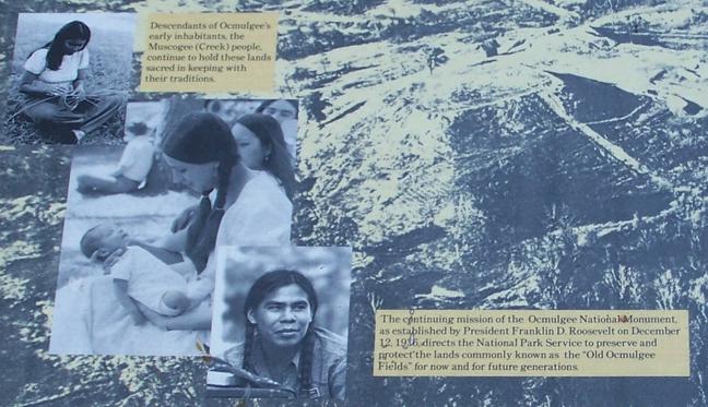
As this work progressed, many archeological treasures were unearthed. Finally, a bill was passed by Congress to authorize establishment of a 2,000-acre Ocmulgee National Park. The archeological effort was the largest excavation ever undertaken in the country. Labor was provided by hundreds of workers employed under several Great Depression-era public works programs. On December 12, 1936, President Franklin D. Roosevelt signed the Proclamation establishing Ocmulgee National Monument and directing the National Park Service to preserve and protect 2,000 acres of "lands commonly known as the Old Ocmulgee Fields..." Due to economic constraints, only one-third of the acreage was eventually acquired; the park presently encompasses 702 acres.
Interstate Highway 16 was built in the 1960s. It was constructed through the Macon Plateau Unit, and cut the primary visitor use area off from the park's mile-long river boundary. During archeological excavation within the highway corridor inside the park, evidence of Muscogee (Creek) and earlier settlements, along with three human burials, were discovered. A number of important prehistoric and historic sites outside the park were destroyed or heavily damaged when construction crews removed fill dirt for road construction. One worker found an Ice Age Clovis spearpoint as this dirt was being removed.
Sadly, the Swift Creek Mounds and Village, type-site for a widespread Woodland Period culture, were destroyed for construction of a Bibb County Sheriff's Department firing range. Dr. Kelly's early archeological collections, still under the care of the National Park Service, are all that remain of this large site, which was located on the Ocmulgee Old Fields near the Lamar Village Unit of Ocmulgee National Monument.
This destructive period ended in 1992. Some local citizens donated donated almost 300 acres, adjoining the park's Walnut Creek boundary, to the National Park Service, and legislation was passed to incorporate it into Ocmulgee National Monument. In 1997, the Old Ocmulgee Fields were determined eligible to become the first National Register of Historic Places listing for a Traditional Cultural Property, or District, east of the Mississippi River. This distinction recognized the area's great significance to the Muscogee (Creek) people. Today, the park's staff, the Ocmulgee National Monument Association, the Friends of Ocmulgee Old Fields, and the park's many volunteers remain dedicated to the mission of protecting and preserving this very special place for the enjoyment of today's citizens and future generations.
Our Tour of the Monument
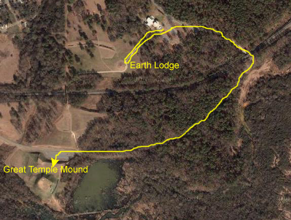
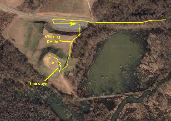
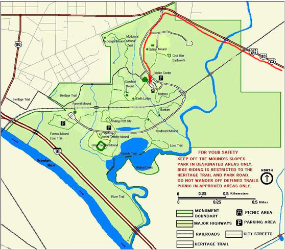
We made two stops here at Ocmulgee National Monument, not counting the Visitor Center. From the Visitor Center, we walked to the Earth Lodge and then back. To get to the Great Temple Mound, we had to drive along the park road.
This aerial view shows you the route we took, and you can also relate many of the features that you'll see in the pictures of the Earth Lodge and the Great Temple Mound to the features in this aerial view.
The Earth Lodge
We had enough time to visit at least a few of the mounds here at the Monument. The first one we walked to was the
Earth Lodge-
a conical mound at the end of a long, straight sidewalk from the Visitor Center. The sidewalk led right up to the
conical mound
and around to the side where the entrance to the reconstructed Earth Lodge has been built. We took two pictures at the entrance to the Earth Lodge- one of
me at the entrance
and one of
Fred at the entrance.
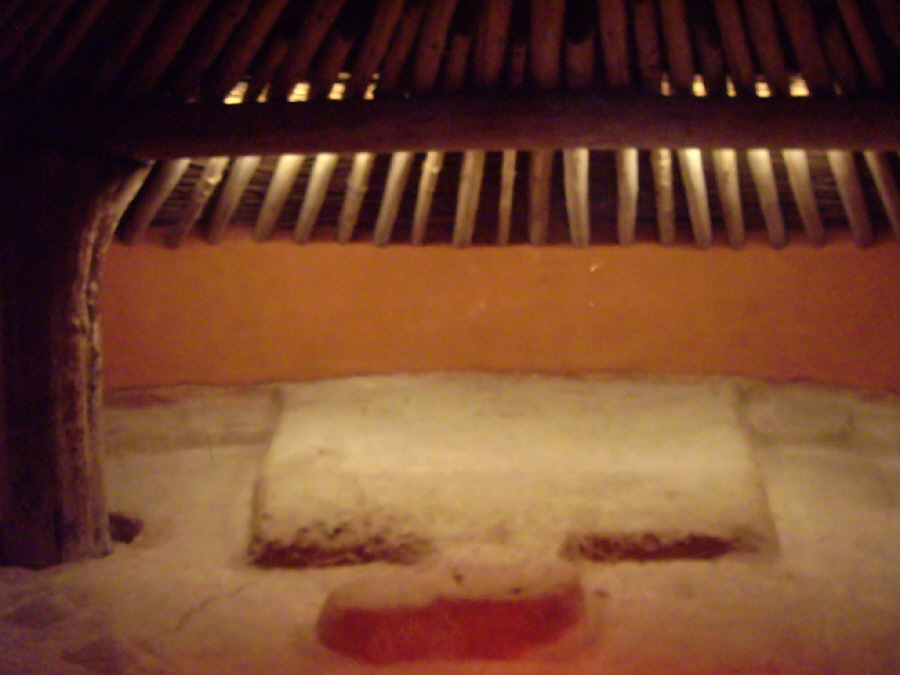
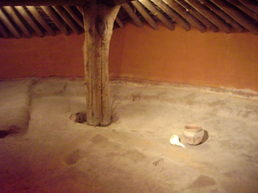
From the entrance, a thirty-foot, low-ceilinged tunnel resembling an old mine shaft led into the interior of the Earth Lodge. The inside end of the tunnel ended in a glass-enclosed viewing room; you could not actually walk out into the Earth Lodge itself. As part of the reconstruction, archaeologists used their best information to simulate what the lodge might have looked like when it was in use hundreds of years ago. Here are thumbnails for three pictures taken inside the Earth Lodge; to see the full-size pictures, just click on the thumbnails:
As we were walking back along the sidewalk towards the Visitor Center, we could look off to the west and see
more of the mounds
that occupy the National Monument.
The Great Temple Mound
We left the Earth Lodge and walked back down the path to the Visitor Center. We'd have to drive to the Great Temple Mound, so we went
back to the car
and then followed the park road from the Visitor Center towards the Temple Mound. Shortly after leaving the Visitor Center, we went through
a short tunnel
underneath the railroad that has figured so prominently in the history of this area.
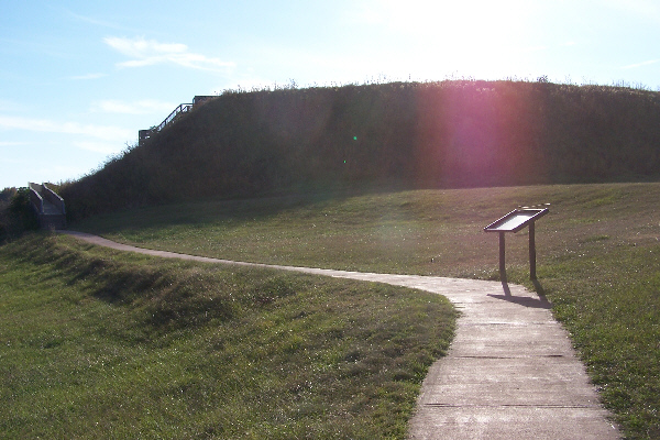
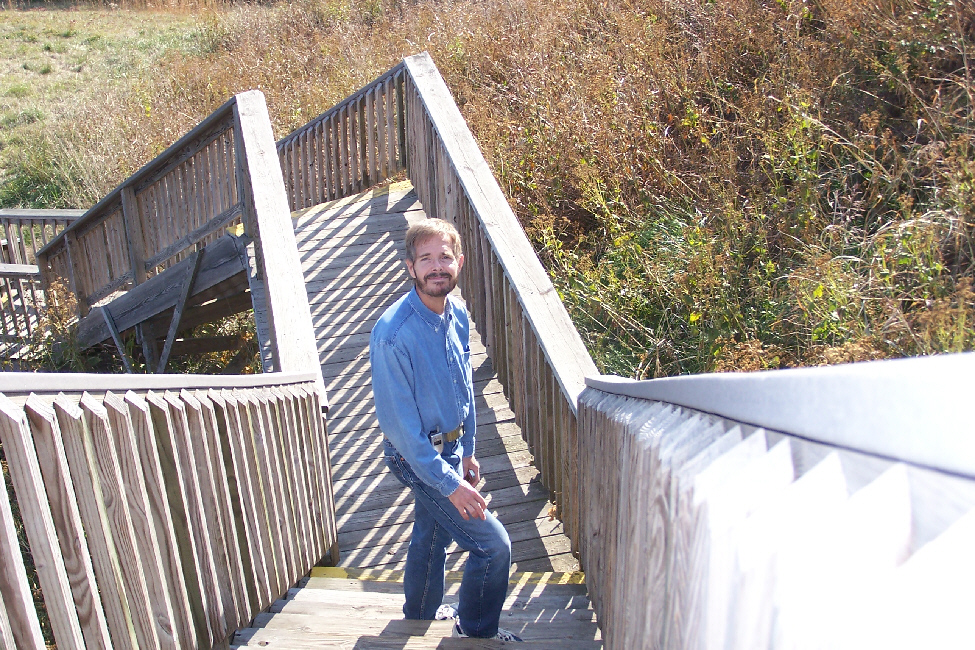
When we got to the parking area for the Great Temple Mound, we got out of the car and headed over to the walkway leading up to the mound. As we climbed up from the parking lot,
we were cautioned
about the meaningfulness of this site to the Native Americans, and, just at the beginning of the walkway from the parking area to the mound found
an informative sign
that described the mound and its significance.
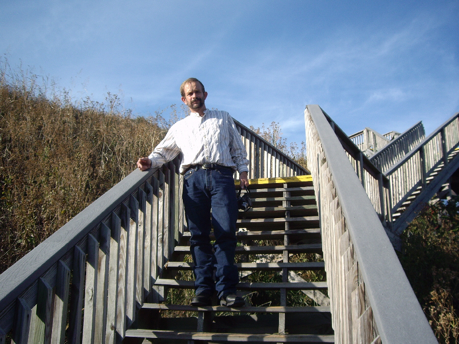
We traversed the
boardwalk
that had been constructed along the east side of the mound (between the mound and
a small lake
next to it), and then climbed up the stairs to the top of the mound itself. Click on the thumbnails below for a couple of views of us climbing the stairs:
The top of the Great Temple Mound was essentially a flat rectangular area, and there were excellent views of much of the rest of the National Monument from the top. Before I detail the specific views, have a look at the movie I took from the top of the Great Temple Mound; this will help orient you to the entire scene. You can watch it with the player at right.
From the top of the mound, we could look
back towards the Visitor Center
as well as off to the northwest at
some of the other mounds
here at the National Monument. Here are three more views- one of
Fred and the Visitor Center,
one of the
park road
and one of
Macon, GA.
And that was basically it for our last stop on this trip. I wanted to allow plenty of time to get back to the airport, so we walked back down to the car and headed off.
Return to the Page Index
Leaving for Home
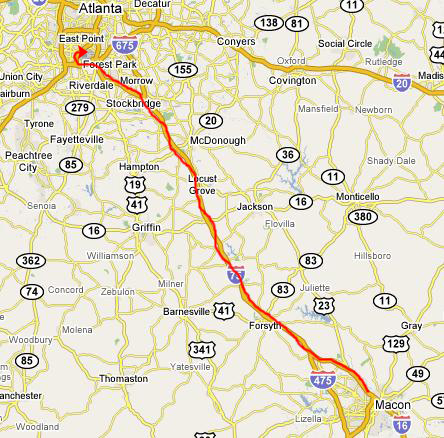
As it turned out, getting home was the smoothest part of the trip. We left the Ocmulgee National Monument about three-thirty, and in about fifteen minutes had navigated the streets of southeast Macon to get back to Interstate 16. It was just a few miles north until we merged onto Interstate 75 to Atlanta.
Then it was a pleasant 90-minute drive up to Atlanta. It was Sunday afternoon, and there was not much traffic- well, not much for Atlanta, anyway. We arrived at the car rental lot with an hour and a half before our flight, hopped the shuttle bus to the terminal, and were through security and at our gate almost an hour before flight time.
The flight home was quite pleasant- just reading and talking about the trip. Our friend Mario picked us up at DFW and we took him out to eat on the way home.
This was a rather different trip for us. Our Fall trips usually involve a lot of hiking and/or camping and while we did some hiking, there was no camping at all. We did a lot of visiting- mostly my own family- which we rarely do. But we did see a lot that neither of us had seen before, and the trip was well worth it, even if it wasn't the most memorable that we have taken.
You can return to today's index
or use the links below to continue to another photo album page.
 |
November 10, 2007: Georgia/North Carolina Trip Day 8 |
 |
Return to Main Index for Georgia/North Carolina Trip |