|
Quebec City (September 14) |
|
At Tony's House in Boston (September 12) |
|
Return to the New England Trip Master Index |
Breakfast in Newport
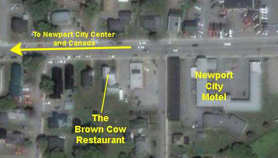 |
The Brown Cow was very much a local place, and it seemed as if most of the folks in the small restaurant (in a converted house) were locals, so this was just the kind of place we were looking for. We shared an omelette and a waffle, and splurged on real maple syrup for the waffle (extra, of course). It was a good meal, and it was fun watching the patrons.
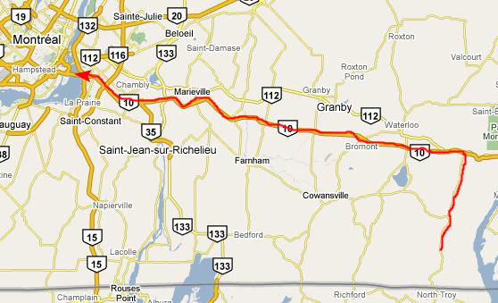
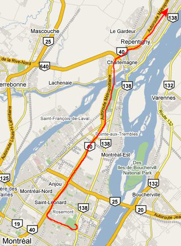
When we were paying our bill, I asked the man running the seating and the register whether my planned route into Canada (going back to I-91) was a good one. He asked where we were headed, and when we said Montreal, he laid out a different route that didn't involve going back east, but taking local roads up to a border crossing near North Troy VT. He said that even though it was only two-lane roads, there wouldn't be much traffic on a Saturday morning, and we wouldn't be doing any backtracking. So I tried to commit his directions to memory and we headed back to the hotel to get cleaned up, load up the RAV4 and check out.
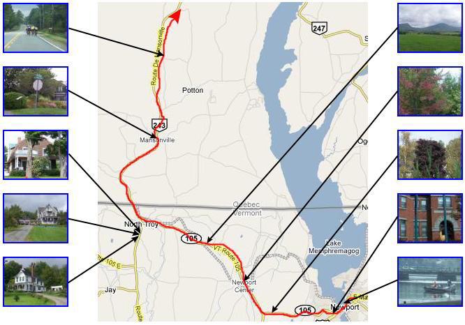
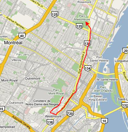
Driving from Newport to Montreal
Along this morning drive, Fred was snapping pictures out the window pretty constantly. He took some while we were going through Newport and on the drive to North Troy, some more of the houses where we stopped in North Troy to ask directions, and a few on the highway north of the border crossing into Canada. Many of these pictures didn't turn out very well (due to the fact that we were moving, I guess) but enough did so that I can include them here. Below you'll find a map of this part of our drive, with some picture thumbnails on either side. I've drawn some lines to show you where along the route the picture was taken. You can just click on the thumbnails, as usual, to view the full size images:
|
Perhaps it was because the border crossing was so small; this road is used mostly by locals, I think, and there were very small guardhouses on either side- one Canadian and one American. Actually, there were two Canadian offials- one woman and one man- but they seemed more interested in where we were from and what it was like in Texas than they were about anything we might be carrying. There were some cursory questions about what we were bringing into the country, but that was about it. Had they not wanted to chat about Texas, the whole process would have taken less than a couple of minutes.
So we were on our way quickly up the highway towards Autoroute 10, an expressway that runs from Montreal southeast towards Newfoundland. We turned west when we got to the highway, and it was a smooth trip to Montreal.
Montreal is on the north/west side of the St. Lawrence River, and as we approached the city on the expressway, Fred used his zoom lens to get our first picture of downtown Montreal. Our first destination is going to be Mont Royal, and you can see that low mountain in the background behind the skyscrapers. As we were crossing the highway bridge over the river, I made a movie of our approach to the city. I had the car window partially open, so when I turned the camera a certain way, I got some wind noise, but I think you can still hear my narration quite clearly. You can watch that movie using the player below:
|
|
Fred took a couple of additional pictures of our approach into the city, one as we came off the bridge and another as our expressway came to an end in the middle of downtown Montreal.
Downtown Montreal
 |
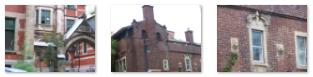
Along this residential downtown street, there were a number of old private homes (5) that reminded me very much of the older (and very expensive) private homes on the near north side of downtown Chicago. Fred found a number of other examples of interesting older architecture as we drove along this street, and he took a number of pictures. Thumbnails for a few of these are below; just click on the thumbnails to view the full-size images:
|
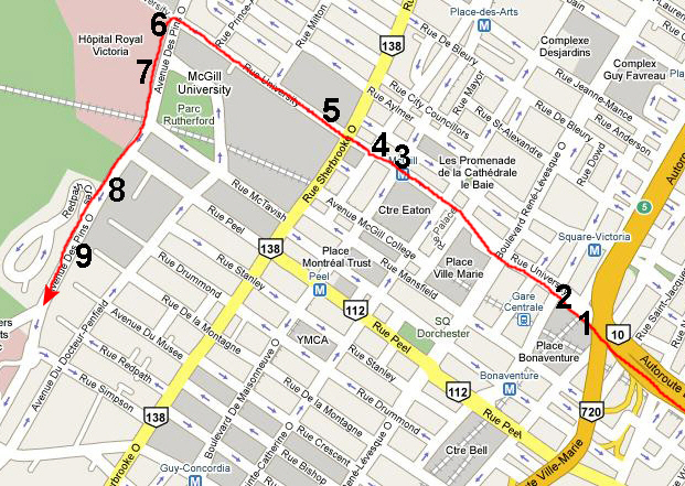
While I was fairly sure where I was going, I am always happy to have confirmation when I am in an unfamiliar place, so as we were driving slowly by McGill University, I pulled into a parking spot temporarily to ask directions to Mont Royal from a couple of young people (probably students) who were standing on the sidewalk. They confirmed that we should continue up University to Avenue Des Pins (we would know it by the Royal Victoria Hospital on the corner), and then turn left go a couple of blocks where we would find the pathways up Mont Royal.
We did exactly that, and ended up right where we needed to be. As we approached Avenue des Pins, Fred snapped a picture of the old, Victorian portion of the Royal Victoria Hospital (6), and as we turned left onto the avenue, we passed the entrance to the Emergency Room ambulance area, with its interesting elevated walkway (7). Just beyond the hospital, the park area began, and we passed some interesting old buildings on the city side of the street as we looked for a parking place (finding a convenient one pretty quickly). Take a look at these old buildings here (8) and here (9).
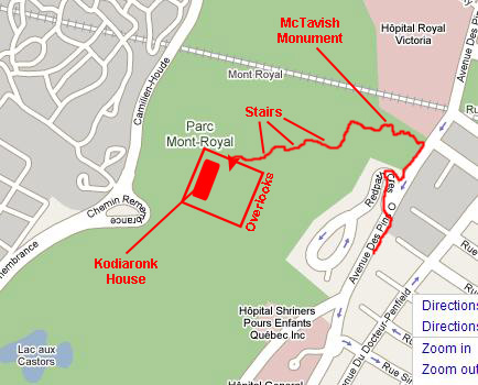
Hiking up Mont Royal
|
|
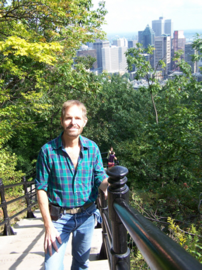
After the McTavish Monument, the trail led up some stone steps, around by where the construction was going on, and up to the park road, where we encountered lots more walkers, joggers and bicyclists. From there, a long set of stairs led up the side of the mountain on the other side of the road, and we started up the stairs ourselves. Along the stairway, we took pictures of each other; here is my picture of Fred and here is Fred's picture of me.
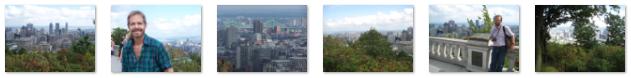
There were a number of flights of stairs, and it was getting a bit exhausting in the warm noonday sun when we finally came out on the top of Mont Royal, and found ourselves at one end of Kondiaronk House. Belvedere Kondiaronk is the mountain top lookout located at the chalet atop Mount Royal. It is the first of two very popular lookouts, the other being known as "Lover's Lookout" and located further East on Camilien-Houde Road (Remembrance Road). Kondiaronk was a great Chief of the Huron First Nations tribe who was present for the signing of what is called "The Great Peace" document between the French settlement on the island of Montreal and the Hurons. The view from Kondiaronk lookout is superb and provides visitors with an excellent vantage point to see the downtown core, as well as sections of the St-Lawrence River, the South Shore and some of the mountains Southeast of the city, like Mont-Saint-Bruno and Mont-Saint-Gr�goire (you can see a sample of this view here.
In front of Kondiaronk House there is a wide plaza that forms a huge overlook for the city of Montreal. There is a wide set of steps that descends to the plaza from Kondiaronk House (and there were a number skateboarders trying their hand at navigating the steps and railings). On either side of the steps, there were large planters full of late summer flowers. Here is a good picture of Fred and the flowers at Kondiaronk House. In the center of the plaza is a plaque with the inscription: "On October 2nd, 1535, Jacques Cartier, discoverer of Canada, climbed this mountain under the guidance of the indians of the village of Hochelaca and, impressed with the beauty of the landscape displayed before his eyes, he gave it the name of Mount Royal, from which the city of Montreal took its name." Before we look at some of the views that Fred and I got from this overlook, you should watch the movie I made of the overlook and the plaza area using the movie player below:
|
|
We spent quite some time walking around the plaza taking pictures of each other and of the city (and cooling off from our climb up to the overlook). Below are thumbnails for the best of these pictures; click on them to view the full-size images:
|
An Afternoon With Flora and Fauna
 |
That's why the route I marked on the map at left has us going the wrong way for a time until we could cut through some residential areas to get back down to Sherbrooke. The route through the residential areas was interesting, and Fred was able to take a few good pictures whenever we slowed down or stopped for a light or turn. Just down the street from where we parked, for example, Fred found a beautiful display of flowers at the southeast corner of the park and, in a small park a bit further on, a really pretty floral clock. In the more residential area, we passed an interesting church building as well as many, many really beautiful old homes.
After a time, and after asking for directions once, we came out on Sherbrooke Street, and then headed north through downtown Montreal towards the Botanical Gardens. Here is a typical downtown street scene along Sherbrooke Street as we drove north.
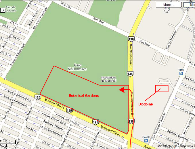 |
We got to the Botanical Gardens easily enough. We planned on doing three things this afternoon. Of course we would wander through the gardens themselves, but we also wanted to visit the Insectarium (which is immediately adjacent to the gardens) and the Biodome which is a block away across Sherbrooke.
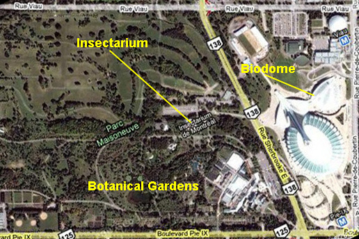 |
So we parked at the Botanical Gardens, bought our combination tickets, and then walked around the perimeter of the gardens and past the Insectarium to the the bus stop for the bus that shuttles between the gardens and the Biodome. As it turned out, we could have walked, but it would have taken about the same amount of time. In any event, we arrived at the bus stop in front of the Biodome in short order.
A Visit to the Biodome
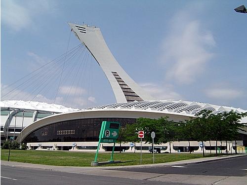 |
When we got off the bus and approached the Biodome building, I was able to make a good movie of the exterior of the Biodome, and you can watch that movie using the player below:
|
|
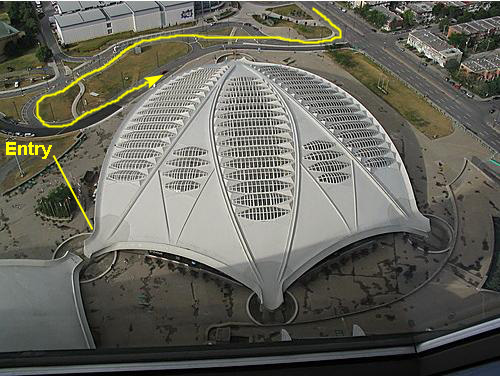 |
The Biod�me consists of four separate ecosystems: a tropical forest, a Laurentian forest that changes with the seasons; a St. Lawrence marine ecosystem, simulating the estuary and the gulf; and polar ecosystems of the Arctic and Antarctic. Each ecosystem is complete with plants and various species of wildlife indigenous to that region.
Overview of Our Tour Through the Biodome
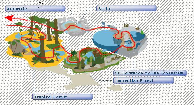 |
We will enter into the Tropical Forest first, then move to the Laurentian Forest (typical of the forested areas in both Eastern and Western Canada), then move through the St. Lawrence Marine Ecosystem (typical of the area of Canada where the St. Lawrence River flows into the North Atlantic and finally through the Arctic and Antarctic ecosystems- saving the penguins for last, apparently.
As we move through the Biodome, I'll deal with our pictures in sections. For each ecosystem, I'll provide a diagram of that particular ecosystem and mark on it generally where the pictures and movies were taken. You'll be able to click on thumbnails to view full-size images, or on markings on the diagrams to look at the movies we took.
The Tropical Forest Ecosystem
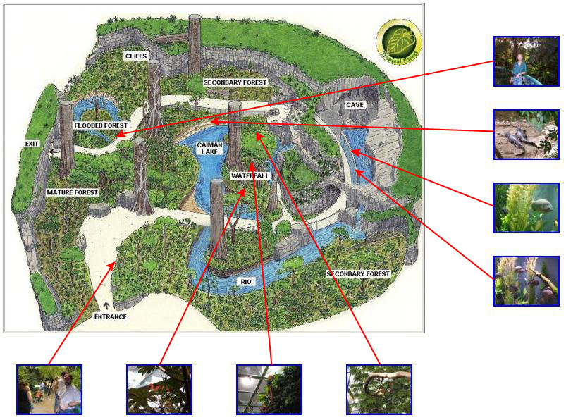
The Tropical Forest at the Biod�me, a reproduction of a tropical rainforest in South America, was the first environment that we walked through. It displays the extraordinary biological diversity of these ecosystems and to their terrible vulnerability. The Biod�me's Tropical Forest, measuring over 21,000 square feet and populated by thousands of plants and animals, is the largest ecosystem.
The landscape evokes a valley carved out by a river, now reduced to a stream. The water flows from a flooded area down to a marsh below. There is a cave on one side of the valley. In the Biod�me's Tropical Forest, the air is hot all year long, with temperatures ranging from 25 to 28�C during the day and 21 to 22�C at night. The relative humidity of at least 70% actually corresponds to the driest time of year in a tropical climate. Artificial lighting ensures that the ecosystem receives the same amount of daylight as it would in Costa Rica.
We crossed through various growth stages in the tropical forest, each with the appropriate flora and fauna. In the young secondary forest, the light easily penetrated through to the ground, while in the mature primary forest, the dense leafy canopy blocked most of the sunshine. The diversity of plant life was staggering: trees with buttresses and stilt roots, strangler figs that choke the trees they sprout on, epiphytes that transform tree branches into gardens, climbing herbaceous plants and lianas stretching up to the sun, and palm trees populating the undergrowth.
As for animals, there were tropical birds, tropical fish (including pirhanas) and alligators. We took a number of pictures as we wandered through the ecosystem. You can look at them by using the diagram below. Each of the thumbnails points to the spot on our walk where the picture was taken; click on the thumbnail to view the full size image:
|
|
The Laurentian Forest
The second environment we traversed was the Laurentian Forest- a reproduction of one of the most beautiful forests in Quebec Province. In nature, this kind of northern ecosystem, a mixed forest where deciduous and coniferous trees mingle, occurs in both North American and Asia at similar latitudes. An ecosystem that awakens, blossoms, changes colour and sleeps in time with the seasons, the Laurentian forest illustrates how living things can adapt to great variations in climate.
The Biod�me's Laurentian Forest consists of hardwoods and conifers. There is a variety of land and aquatic habitats dotting its 10,000 square feet , whose denizens are often most active at night. Just as in nature, changes in temperature and light cause plants to become dormant toward the end of the summer. The leaves change colour and drop off in the fall, and in the spring, the cycle starts again as plants sprout anew. In fact, spring actually comes slightly ahead of time in the Biod�me's Laurentian Forest!
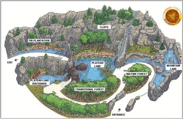 |
Conditions in the Biod�me's Laurentian Forest change considerably from one season to the next, to reflect the actual conditions outside. The temperature reaches 23�C at the height of the summer, and gradually falls to 4�C at night (12�C in daytime) to induce plant dormancy. The lighting is also shortened, to encourage this plant "winter," which lasts 8 to 12 weeks. Relative humidity ranges from 45% to 90%. All of these changes are induced by the overhead lighting system and the air-conditioning.
In the Biod�me, there are both hardwoods, including sugar maples and white birches, and conifers such as firs and white spruces, occurring naturally in the Laurentians, in habitats specifically suited to their growth. In one portion of the habitat, a pile of logs gives the impression of a beaver dam. You can see many of these tree types in my movie of the Laurentian Forest habitat that you can watch using the player below, left.
|
|
As this dormancy period ends, plants wait for the proper conditions for "bud burst." Temperatures of 4�C to 10�C are generally sufficient to coax them out of dormancy. In Qu�bec, the dormancy period is considered to end in March, but the persistent low temperatures delay bud burst until May. All this is to say that Nature leaves the Biod�me just enough leeway to manufacture "real" seasons in the Laurentian forest, through careful control of photoperiods and temperatures.
The different terrestrial and aquatic habitats are populated by animals that are generally more active at night. Among the inhabitants of this ecosystem are dozens of species of fish, along with amphibians, reptiles, birds (left-hand movie player below) and mammals such as beavers (viewed underwater as the pathway descended through a short tunnel in the right-hand movie player below), porcupines, otters and lynx.
|
|
|
|
St. Lawrence Marine Ecosystem
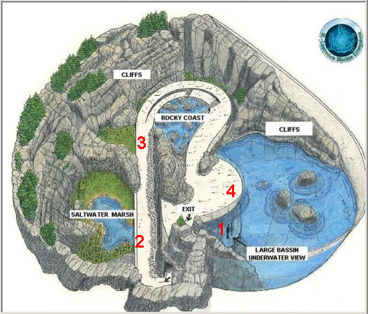
The third ecosystem we walked through here in the Biodome was called the "St. Lawrence Marine Ecosystem," and it represents a veritable inland sea, where the St. Lawrence Estuary and Gulf extend from Tadoussac (at the mouth of the Saguenay River) all the way to the Atlantic. The fish-filled waters of this ecosystem are teeming with plankton, a food source that attracts many whales. The Biod�me's ecosystem, covering a total area of 11,000 square feet and featuring a basin holding 700,000 gallons of "sea water" produced right here at the institution, reveals some of the shapes and colors hidden in these cold, salty waters.
 |
|
|
|
|
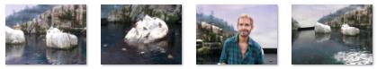
The path continues around and along a rocky, wave-beaten shore whose bottom is strewn with a variety of invertebrates and steep, rocky walls where seabirds nest. The granite rock recreates landscapes shaped by ice and millions of frosts and thaws. The rocky cliffs were an interesting backdrop (#3 on the diagram above) for pictures of Fred and myself.
The ambient air in the St. Lawrence Marine Ecoystem is kept at a much milder temperature than in the natural environment: in the summer, 17�C during the day and 15�C at night; and 15�C in winter. The relative humidity is much higher in the summer (60 to 70%) than in the winter (23 to 30%). The water temperature (10�C) and salinity (30 parts per thousand) mimic the natural conditions of the Estuary. The water is treated continuously, through mechanical filtration (sand filters) followed by biological filtration and, finally, ozone purification.
Although the thin, poor soil that accumulates in the crevices of the rocks is not ideal, the common juniper and some coniferous trees still manage to find a foothold. The ecosystem also features a number of plants characteristic of transition areas between marine and land habitats.
The huge basin is home to hundreds of fish representing some 20 species (cod, striped bass, halibut, salmon, etc.). Invertebrates such as starfish, sea anemones, sea cucumbers, limpets, sea urchins and crabs-are plentiful on the rocky shore. The winged world is represented by Kittewakes, common eiders and American green-winged teals, to name just a few. Most of the birds were around towards the end of the path through this ecosystem, where a matte painting served as a distance backdrop for the formed cliffs and simulated Atlantic shore (#4 on the diagram above).
|
|
|
The Polar World
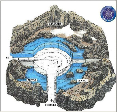 |
It was interesting that just inside the entrance to the Arctic/Antarctic habitat there was a simulated water flow for the benefit of those puffins, and they seemed to enjoy "surfing" the flow, as you can see in the movie I made (which you can watch using the player below:
|
|
Just past the subarctic section of the habitat we finally came to the Antarctic habitat, which was dominated by the snowy cliffs and penguins, all inside an enclosure kept just above freezing. The landscape evokes the shore of a volcanic island lying between the Antarctic peninsula and the tip of South America. Basalt is the main rock formation. The temperature is kept relatively constant, between 2�C and 5�C. The photoperiod (length of daylight) matches the natural cycle in the region. No natural vegetation is present, but the penguins provided enough entertainment for the visitors who could take seats in a small amphitheatre and watch them. Fred took three excellent pictures of the penguins, and you can look at those pictures here, here and here.
 |
An Afternoon in the Botanical Garden
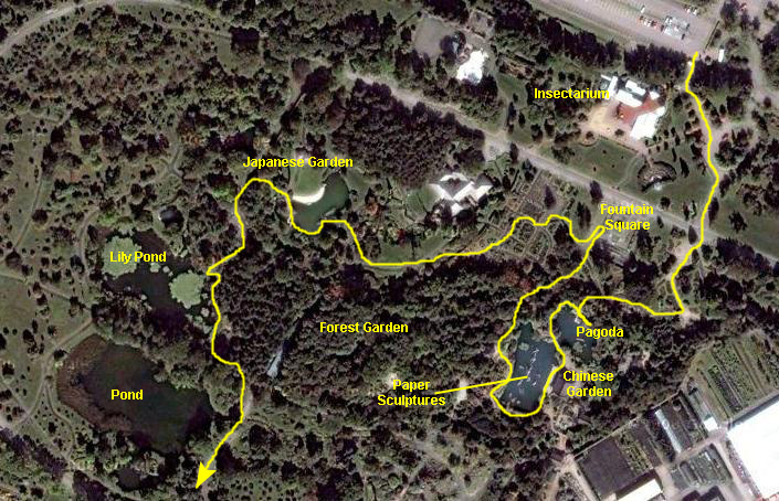 |
As I include the pictures that we took on the first part of this afternoon's walk, I'll refer to the areas I've marked on the aerial view so you can see where the various pictures were taken.
Entry to the Chinese Garden
|
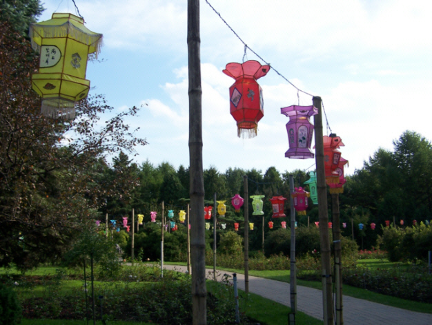
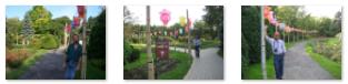
From there, we followed a winding paved pathway that led to the actual entrance to the Chinese Garden. The pathway was lined with multi-colored Chinese lanterns. We didn't know it at the time, but these would all light up when it got dark. Thumbnails for the three best pictures we took along the pathway are below; click on them to view the full-size images:
|
The Chinese Garden
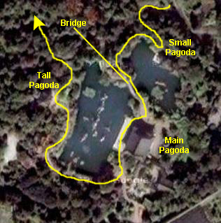 |
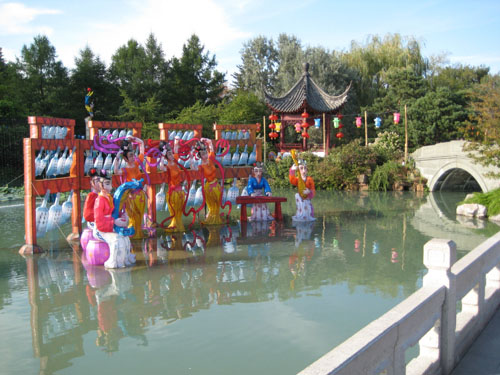
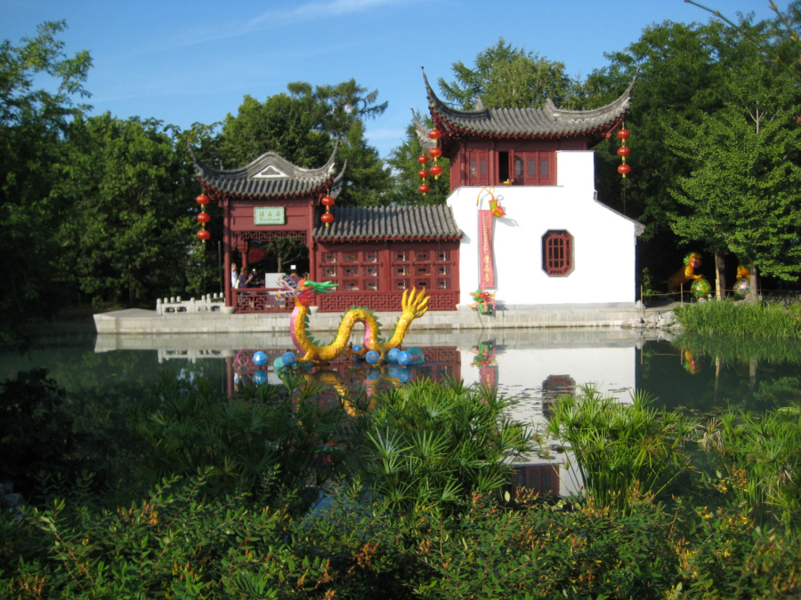
Entering the garden from the top of the aerial view at left, we stopped first at a small pagoda-type structure alongside a small section of the pond on the north. Then we crossed a bridge over the pond to arrive at the main pagoda complex, which is actually two or three separate buildings. From there, we went around the south end of the pond and over to the opposite side where there is another, much taller pagoda that overlooks the pond.
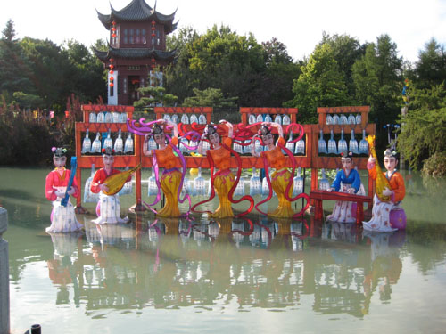
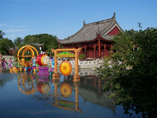
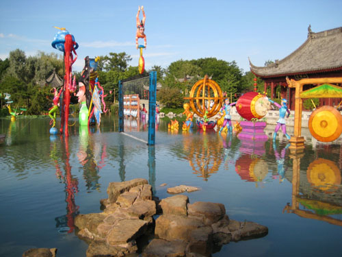
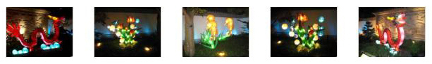
When we got to the first pagoda on the north side of the pond, we found that we could look across that small northern section of the pond towards the main pagoda complex and we could see one of the first paper sculptures out in the middle of that section of the pond- a dragon. Near this first pagoda, there was another set of paper sculptures in the water- two dancing figures. Also adjacent to this first pagoda there was another, more complex paper sculpture out in the water, this one of a couple of jugglers and an acrobat on a pole. You can see this sculpture and the tall pagoda in the background here.
We were too close to this first pagoda building to take any pictures of it at this point; there was no place to back far enough away to get a good shot. So we walked around the north side of the pond and then crossed the stone bridge that led across the pond to the main pagoda. Once we got out on the bridge, we could get some good views back towards the first pagoda we stopped at, and we could also see the entirety of the north side of the pond and get our first view of the main pagoda and the various colorful sculptures in front of it. There are thumbnails for these pictures below; click on them to view the full-size images:
 The First Pagoda and The Olympic Tower |
 The Main Pagoda and Paper Sculptures |
 Lily Pond and The Olympic Tower |
 The First Pagoda and Dragon Sculpture |
We walked around the end of the pond at the north end of the Chinese garden and across a stone bridge to the main pagoda that lies along the east side of the pond. When we got there, we walked out onto the esplanade that faces the pond and I made a movie of the pond in the Chinese garden that you can watch using the player below:
|
|
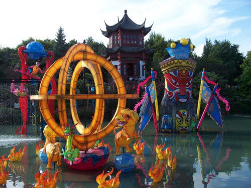
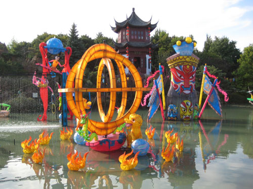
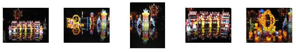
We spent some time at the main pagoda area looking at the colorful sculptures out in the middle of the pond, and then we walked around the south end of the pond to a tall pagoda on the opposite site (and from there to the exit from the Chinese garden). Below are some of the best pictures we took here- pretty much in the order of our progress through the garden:
|
|
|
|
|
|
|
Fountain Square
 |
The Japanese Garden
 |
On our side of the pond there were stands of white flowers (shown in the picture above), and an artificial stream and waterfall that was part of the circulation system for the pond. We walked around the west end of the pond and crossed the bridges on the north side, discovering that the pond was stocked with koi.
Lily Pond and Lake
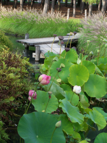 |
Along the way, we passed by the lily pond. It had a short dock you could sit on and view the various water plants (this dock shown in the picture at left) as well as some rocks that allowed you to walk out a short distance from the shore paths. Here is Fred at the lily pond.
Fred also took a couple of close-up pictures of the lily pads and some of the flowers bordering the pond, and you can look at those pictures here and here.
From the lily pond we walked further south past a rather larger lake that is right in the center of the gardens, and over to the south side of the botanical gardens.
Demonstration Gardens / Specialized / Bedding Plants
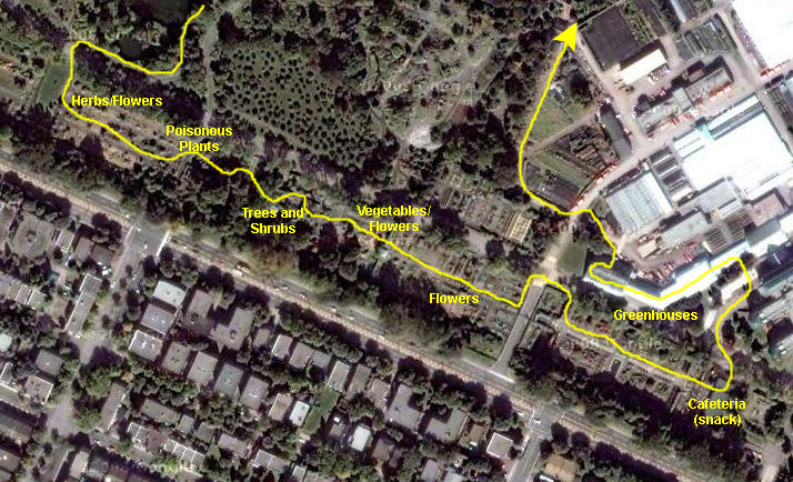 |
There was, oddly enough, a section devoted to vegetables and their flowers. And there was section after section of small trees, foliage plants and bedding plants. When we'd worked our way down towards the main buildings, we stopped in a small restaurant for a snack before heading over into the greenhouses.
As we reached the end of the gardens, Fred found an interesting wall fountain and sculpture, and I made a movie in the fading afternoon light of a particularly beautiful arrangement of begonias. In this movie, you can also see the building at the end of the gardens that housed the restaurant. You can watch that movie using the player below:
|
|
On our two-hour walk through this portion of the Botanical Garden, both Fred and I took a number of pictures, and you have seen a good many of them already.
|
To view the slideshow, just click on the image at left and I will open the slideshow in a new window. In the slideshow, you can use the little arrows in the lower corners of each image to move from one to the next, and the index numbers in the upper left of each image will tell you where you are in the series. When you are finished looking at the pictures, just close the popup window.
The Greenhouses
 |
In any event, the greenhouses were as interesting as many others we have toured. While there were some flowering plants, the emphasis here seemed to be on palms, cacti and bonsai. We did enjoy touring through the greenhouses, and I have selected some of the better pictures that we took for inclusion in the album here.
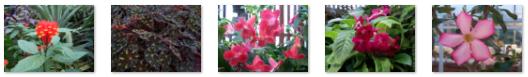
First, as I said, there was a section of general flowering plants, and Fred found a number of interesting plants with which he wasn't familiar. Here are some pictures of these flowers and foliage:
|
There was also a section of this same greenhouse that had a waterfall and focused on tropical foliage, but the light in that particular greenhouse wasn't really sufficient to get a lot of good pictures of it.
It seemed as if the greenhouses focused on cacti; there were certainly more of them than of any other plant, and both Fred and I took a good many pictures of them. If you will click on the thumbnail images below, you can see some of these pictures:
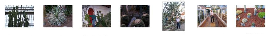
|
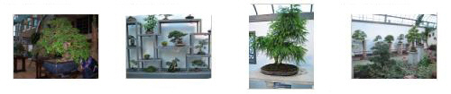
It seemed as if another focus of the exhibits in the greenhouses was on bonsai; there was a whole house devoted to this form of ornamental horticulture. At left are thumbnail images for some of the pictures we took in this area of the greenhouses. click on them to see the full-size pictures. |
We spent some more time wandering through the greenhouses; Fred was in his element. We saw some unusual cycads, as well as two tall plants that Fred had not seen before. You can see pictures of them here and here.
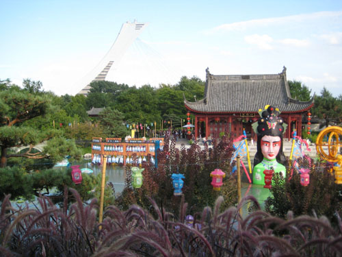
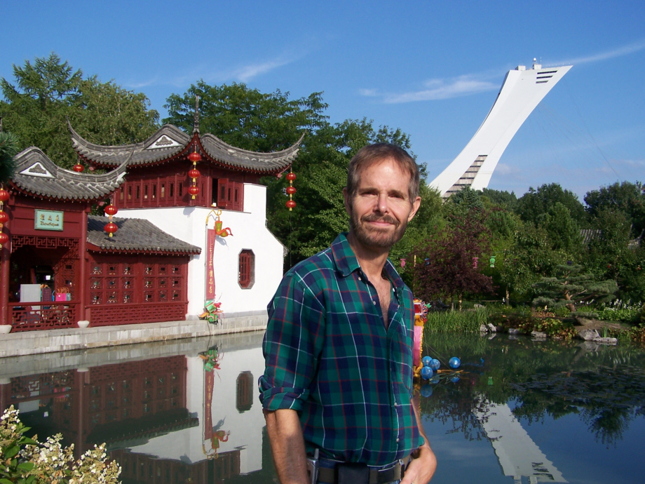
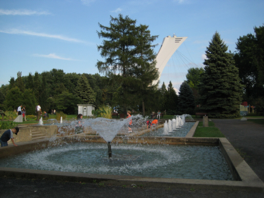
When we came out of the greenhouses, the light was going and the lamplights had come on throughout the garden. We got another good view of the Olympic Tower as we made a decision to head over to the Insectarium.
Touring Through the Insectarium
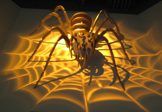 |
Pictures didn't seem to work well in the exhibit halls, and in any case taking a lot of pictures of individual exhibits didn't seem to be too beneficial, so we contented ourselves with the two included here. After spending about an hour and a half wandering through the Insectarium, we actually intended to leave the Botanical Gardens and head off towards Quebec City, but we learned that every evening all the paper sculptures in the Chinese Garden are lit up, and that this is one of the major attractions here in the gardens. And so, when we left the Insectarium, that is where we headed. All we had to do was follow the crowds.
The Chinese Garden at Night
 |
Around the walls of the courtyard there were more of these sculptures; they were all very beautiful, and I've picked a selection of the photos that Fred and I took of them to include here. Please click on as many of the thumbnail images below as you wish to see how beautiful these things were:
We went on through the building to come out on the dock in front of the pond, and we were greeted by a fantastic display. The sculptures out in the middle of the water, colorful as they were earlier in the day, were now electric with color. The crowds of folks admiring and enjoying them (some of them moved and turned mechanically or in the breeze) made it seem like some fantastic holiday. To try to give you an appreciation for what it was like, I did take a movie of the sculptures, and I hope you will take a moment to use the movie player below to watch it.
|
|
But we also took a number of still pictures, and these, too, show off the sculptures to good advantage. Click on the thumbnail images below and you will see what I mean:
Dinner and the Drive to Quebec City
 |
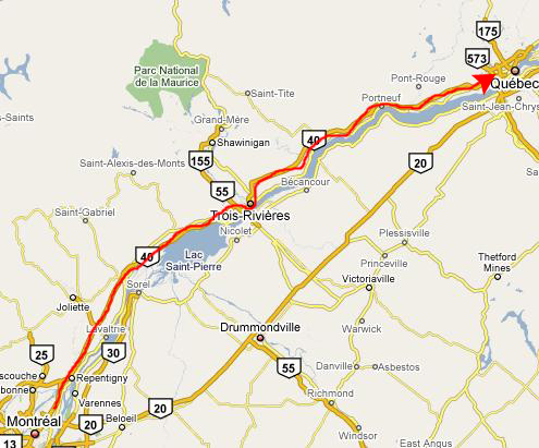
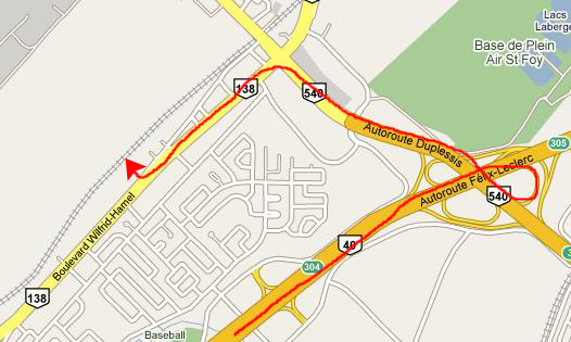 |
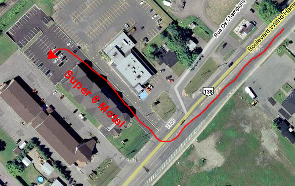
It was a typical Super 8 motel, although it seemed to be a bit nicer than most. We parked in the back and hauled our stuff up to the third floor, found our room, downloaded our pictures and retired for the night.
You can use the links below to continue to another photo album page.
|
Quebec City (September 14) |
|
At Tony's House in Boston (September 12) |
|
Return to the New England Trip Master Index |