|
Acadia National Park- Day 1 (September 15) |
|
Montreal, Canada (September 13) |
|
Return to the New England Trip Master Index |
A Visit to Montmorency Falls (Chutes Montmorency)
Getting to Montmorency Falls
 |
So, there wasn't much sense in just driving on down there right away. I got on the Internet to see if I could find something we could do here in Quebec City that didn't involve being outdoors, but there wasn't much. We could do museums and such, but I didn't think that was a good way to spend the day in what is, sadly for our bad weather, a beautiful city.
I did find, however, that there was a major waterfall, one of Eastern Canada's largest and certainly easiest to get to, just a few miles further down the St. Lawrence River from the center of Quebec City. So I plotted out a route to get there, and then got back in bed for a while.
We were both up and ready to leave by about eleven; I didn't see any need to rush because of the weather. We got a recommendation for a breakfast place from the front desk, and drove down the street to find it. When we got there, we found it to be an extremely popular place, and there was a very long wait for a table. So we just ate some granola bars and I drove off toward Montmorency Falls.
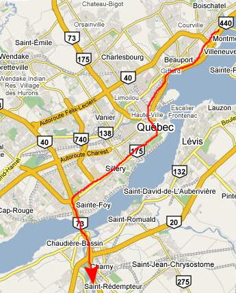
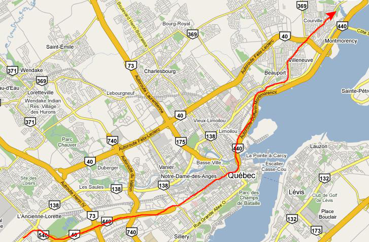
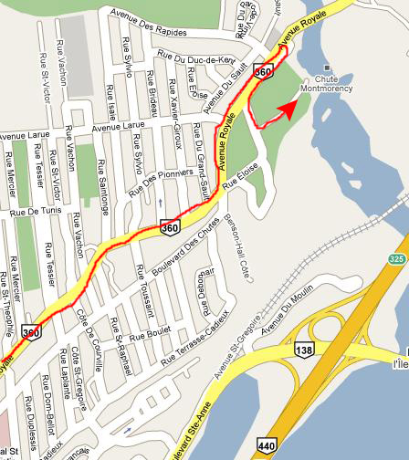
As you can see from the map, getting to the vicinity of the falls was pretty easy. It's a straight shot through the city (had I known, we could have taken an expressway just about all the way) and out the Avenue Royale to the entrance to the Falls.
 |
Montmorency Falls and Park
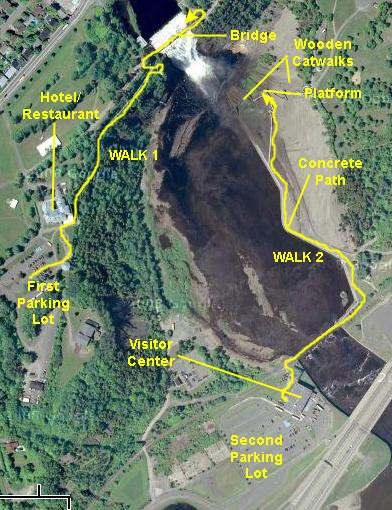 |
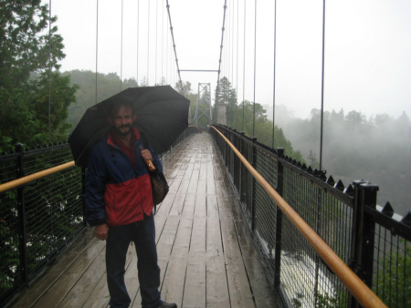
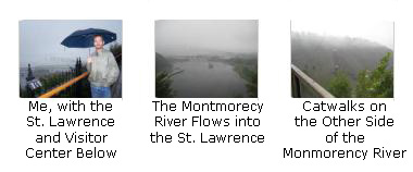
From the first parking area, we walked up towards the Hotel/Restaurant, and then along the wood-and-metal cliffside walkway. We took this all the way to the falls. Right at the falls, we went down a couple of flights of steps to an overlook. We were quite near the falls, looking slightly up at them.
Then we went back up to the main path, up some more steps, and then across the bridge over the falls. There were great views from here, but they would have been absolutely amazing had the weather been sunny and clear. As it was, we could barely see the St. Lawrence, even from the top of the falls. We crossed to the other side of the bridge to get more pictures. Then, we went back to the car.
As we were going back out the gate, the attendant reminded us that our parking fee was good for the visitor center as well. We hadn't known there was one, but he gave us directions through residential streets and down the cliffside to the level of the river, and then back northeast a bit to the entrance to the visitor center. We parked there and took another walk to the base of the falls.
This walk took us over the Montmorency River and then along the northeastern side of the river on a concrete path until we reached a series of wooden and metal staircases that led up to observation platforms below the falls, and indeed all the way up the cliff face to what was supposed to be a third entry area. We just went to the second or third platform to get some pictures looking up at the falls.
You can use this short description and follow along on the aerial view to see where the pictures we've included here were taken.
Walk #1: To the Top of Montmorency Falls
|
As we were walking along the pathway, we stopped occasionally to take some pictures. You can click on the thumbnail images at the left to see them. |
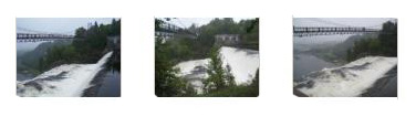
When we got to the end of the walkway near the falls, we went down the steps to the observation platform where we could get excellent views of the falls. Here are two good pictures- one of the top of the falls and one of the bottom of the falls.
|
|
|
From the bridge, we could also see catwalk system on the other side of the river. (You can also see the concrete walkway the borders the river; we will be walking along that path a bit later on today.) Had the weather been nice, it would have been fun to walk up and down the wooden and metal catwalks, and I am sure we could have gotten excellent pictures of the falls.
|
|
We crossed the bridge and found that the path continued to the other parking area on top of the hill on the other side of the river, but since we had no intention of walking down the catwalks on that side, we stopped at an overlook that was right at the side of the river on the far side of the bridge and slightly upstream.
At this overlook, we could get some excellent views (well, excellent given the weather) of the river, the bridge, the cascade and the St. Lawrence River in the distance. We've selected three good pictures from here, and you can look at them by clicking on the thumbnail images below:
|
|
|
So we were done with our walk here to the top of the falls, and we retraced our steps back across the bridge and back down to the hotel and parking area. There, we found an interesting fountain, and Fred wanted me to get a picture of it. Then we got some directions to the visitor center from the fellow manning the parking entrance station and we headed off down the hill.
Walk #2: To the Bottom of Montmorency Falls
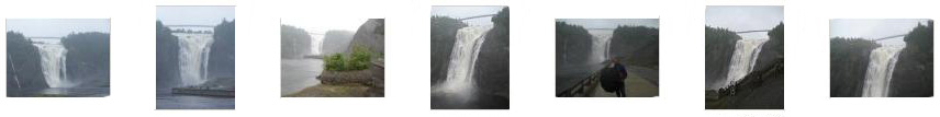
We found the Visitor Center with little problem, parked, and went inside to look at the exhibits before walking out to the falls. The exibits were informative; one of the most interesting was a series of photographs taken during an especially cold winter six years earlier where the falls (and the river) had frozen solid (with the only flowing water deep within the ice). The pictures of people standing on the ice at the base of the falls, and even ice-climbing up the frozen cascade, were pretty amazing. It would have been immensely interesting to watch a film of the ice thawing enough to free up the falls; I wonder how that happens.
As soon as we walked outside the center, the first thing we saw was the hotel/restaurant and tramway; we'd seen a tram stop when we were up on the hill, but weren't quite sure where it went. Now we knew. We also got our first ground-level view of Montmorency Falls in the distance across the river delta.
Then, as I mentioned earlier, we walked across the river on the pedestrian bridge and then along the concrete river wall right up to the falls. There, we climbed up the wooden stairways to get to a platform that offered good views of the falls. We took a great many pictures of the falls on this walk and from the platform but we've chosen only the best of them to include here. You may not want to look at all of them, but do click on at least a few of the thumbnail images below to see some excellent views of "Chutes Montmorency":
|
|
|
|
As we headed out from the visitor center, we passed another small waterfall; I wasn't sure if this was a permanent waterfall or just due to all the rain that had occurred in the area; perhaps it dries up in the summer. We drove on down the street, past an interesting church and on down until we found a restaurant where we could have lunch. As it turned out, it was the same restaurant as we tried to eat at earlier- just a different location.
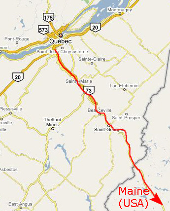
Driving to Bangor, Maine
|
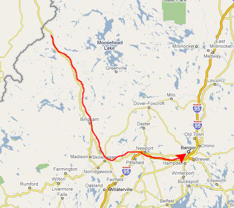
Then we were on US 201 South, continuing for a couple of hours until we found US 2 East. At Newport, we picked up I-95 and took that on into Bangor.
|
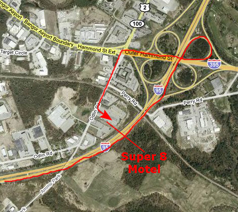
Finding our Super 8 Motel was pretty easy, as you can see from the right-hand map, and we were well-positioned to get on the highway that would take us south tomorrow towards Acadia. We got a pretty good recommendation for dinner, relaxed with a frozen drink and then went to eat. When we returned, we checked the Weather Channel web site; the forecast was hopeful, saying that the next day should be just cloudy, and the few days after that much nicer. Maybe crossing our fingers helped.
You can continue on to another album page with the links below.
|
Acadia National Park- Day 1 (September 15) |
|
Montreal, Canada (September 13) |
|
Return to the New England Trip Master Index |