|
Acadia National Park- Day 2 (September 16) |
|
Quebec City, Canada (September 14) |
|
Return to the New England Trip Master Index |
Getting to Acadia National Park
Our Drive to the Campground
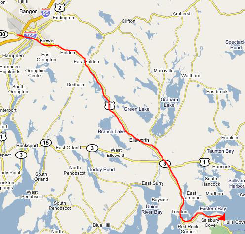 |
We took I-395 from the hotel southeast until it intersected with US 1 south, and we took that until we could get on Maine Highway 3. This highway leads onto Mt. Desert Island and then over east to Hull Cove where one of the entrance stations for Acadia is located.
On the way down to the island, we stopped at a satellite office of the Park Service, and got our entry permit as well as our campsite assignment. As it turned out, there were plenty of sites available, so we weren't under particular time pressure to get there early to pick out a good one.
|
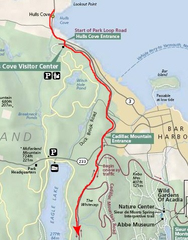
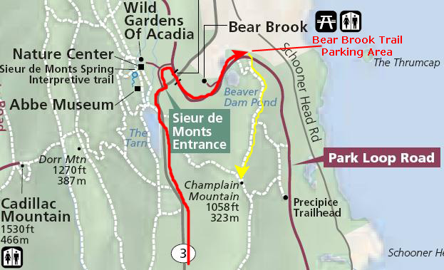
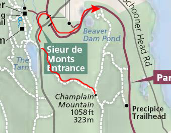
So, we had two options to get to the campground. We could have stayed on Route 3, gone through Bar Harbor, and then south through the middle of the park. Or, we could get on the loop road, go south around the western half of it, and then exit the loop road to get to Route 3 and head a bit northeast to the campground. You can follow both of these options on the two maps above. We thought it might be best to avoid the Bar Harbor area and the potential traffic, and take the more circuitous but probably less-traveled route to the campground.
An Orientation to Acadia National Park
|
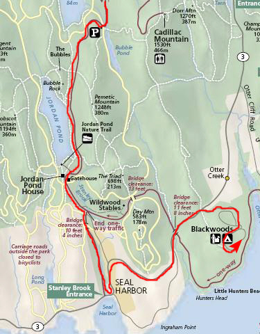
When the entrance road hits the actual loop, then you have to make a choice. If you head east, the road is one-way. If you go south, towards Jordan Pond, the road is two-way. When you get to the junction south of Jordan Pond that leads to the Stanley Brook Entrance, then the road becomes one-way coming at you, so you either have to turn around and head back north, or you have to go ahead and exit the park at Seal Harbor.
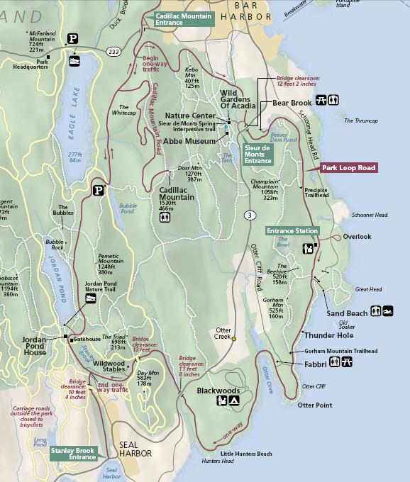
In fact, to get to the campground, that is exactly what you have to do. If you will follow Route 3 from the Stanley Brook Entrance through Seal Harbor, you will see that you eventually come to the entrance to the campground. If you continue on North, you will first come to another entrance onto the loop road and then, eventually, to the town of Bar Harbor. If you take the entrance onto the loop road, you must turn southeast and follow the shoreline, since the road is one-way.
The only other oddity is the connector road that leads from Route 3 south towards Otter Point. This is not a park road, so it is two-way. But you can use it to return to the campground from the loop road if you take either of the turns onto it that are on either side of Otter Point. You can also use it to get to the portion of the park loop road that goes from Otter Point to Jordan Pond.
"Why is the road one-way at all?", you might ask. The answer is that during the tourist season (which, for Acadia, is all the time) there are lots of tour busses that travel the loop road, stopping at the vistas and turnoffs near the shore (not so much in the interior of the island). When they do, there is not enough room in the small parking areas for them to pull off the road, and so they must simply park temporarily in the roadway. If the road were two-way, then it would be almost impossible for other cars and busses to pass them against oncoming traffic. This problem was solved by making the two-lane road one-way heading south. (There are signs forbidding any parking or stopping in the left-hand lane.) Although the system means that you sometimes have to go out of your way to get to a particular place, it greatly enhances the driving experience, as traffic jams are basically eliminated.
For example, even though Thunder Hole, for example, is only about a mile as the crow flies from the campground, to get there we have to drive three miles north along Route 3 to the Sieur de Monts Entrance, and then three miles south along the loop road. But this is not really that much of a problem, since folks would rarely go back and forth to the same place frequently. Most tourists would simply "do" the stretch along the shore in a single day. We went back and forth some, but even so the one-way system was not an onerous burden.
So, we got to the campground easily enough, found our excellent campsite (off in the back of the campground where we had things pretty much to ourselves), set up our tent, had a snack and then headed off to our first stop- Otter Point.
Otter Point
 |
After we parked and walked across the loop road, we found the trail down to the point, and so we headed off down it as I filmed a movie of us on the trail that you can watch using the player below:
|
Walking Down to Otter Point (Mouseover Image Above for Video Controls) |
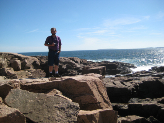
When we got down to the point, we found a pretty amazing place. This was the first time we'd visited the rocky coastline of New England- either one of us. And what we found was something like what we'd seen on the rocky northern coast of California or Oregon- just on a smaller scale. The ocean was very blue and the waves very white, and in the bright sunshine (a welcome change from the clouds we'd had for the last six days) everything sparkled.
|
|
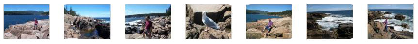
The point itself is just a rocky outcropping such as you will find up and down the Maine coast, but it was particularly beautiful jutting out into the water. Perhaps my movie of the crashing surf (that you can watch using the player at left) will get across to you how great this place was. We also took quite a few pictures, Fred and I, of each of us (and some local wildlife) out here on the rocks.
I've selected some of the best shots to include here; click on the image thumbnails below to look at these pictures:
|
Climbing Champlain Mountain: The Bear Brook Trail
 |
|
|
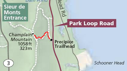
So we headed off. I've marked the trail up to the summit on the map above. As we began the hike, I made a movie of the beginning of the trail that led up through the trees, and you might want to watch that movie using the player at left. The trail was pretty easy to follow; although it crossed a number of areas of bare rock, there were cairns to lead us to the other side and the trail's continuation.
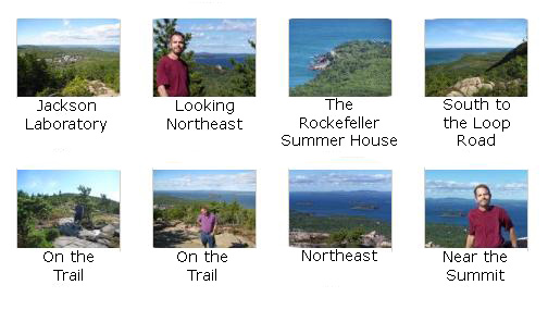
The trail was not difficult at all, and we made good time heading up. After the clouds, cool weather and rain of the last few days, it was very pleasant to be able to hike in the sunshine, and in short sleeves, no less. On the way up to the summit, we took a number of pictures, and I want to include some of them here. From left to right and from top to bottom in the set of thumbnail images below, the pictures are roughly in order of our ascent. Click on those thumbnails to view them:
|
|
|
At the Summit of Champlain Mountain: The Precipice Trail
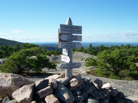 |
From the top, we could see from Bar Harbor all the way out to the ocean; the views were tremendous. Below are thumbnail images for some of the best of the pictures we took at the summit; click on them to see the full-size images:

|
|
|
 |
But I thought we should at least check it out, and so we headed off as I filmed a movie as we started out. You can watch that movie using the player below:
|
|
Sure enough, pretty quickly the trail got very steep as it descended the cliff face, and we found our first short stairway in the rock. From there, things only got steeper. It wasn't that the trail was bad or that the rocks were loose or that there weren't handholds when you needed them. Rather, it was just knowing that if you didn't grab onto the handhold, or got dizzy or something and missed a step, you could fall really, really far.
|
|
|
I sat here for a few minutes, and then came to the conclusion that I did, indeed, have enough anxiousness about the trail and my own ability to navigate it, that I should not attempt it- at least not by myself. I thought that maybe in the next day or two we might try ascending the trail from the bottom; perhaps that would be less intimidating. In any event, I decided to go back up to meet Fred, which I did, after making a movie and recording the view around me and my decision to head back up. You can watch that movie using the player at left.
Descending Champlain Mountain: The Beachcroft Trail
 |
The path we actually followed led off across the bare rock for a ways, and then down the side of the mountain. By the time we could see a view to the distance, we realized that we were not headed towards the ocean, but rather towards the center of the island- the opposite direction. By the time this realization became a certainty, we had descended too far to turn back. We did have a good idea where we were headed and, in any case, we had to reach the road sooner or later, so we pressed on.
|
|
 |
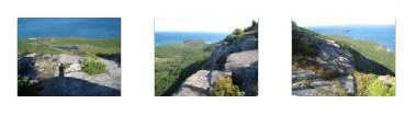
As it turned out, this trail was more interesting than the Bear Brook trail. Our trail used a series of switchbacks to descend across a cliff face. It wasn't a steep one, but it was steep enough so that in places actual stairs had to be cut into the rock face. You can see some pictures of the trail by clicking on the thumbnail images below:
 |
|
|
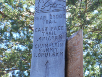
When we finally got back down to the road, we found ourselves, as we suspected, at the trailhead for the Beachcroft Trail, as the trail marker confirmed.
A First Visit to the Thunder Hole
Continuing south on the Loop Road, we had continual views of the Atlantic shoreline in the afternoon light. Then we reached Thunder Hole.
Thunder Hole is a formation much like the blow holes that we have seen in Hawaii and on the coast of Oregon. As the information sign indicates, water is forced into the rock formation by wave action and by the tides. As it rushes into the narrow crevasse, it is forced into a partially submerged tunnel and, if the level of the water is just right, there will be a "thundering" sound as the water hits the roof and the back of the tunnel. If the tide is too low, the water doesn't enter the tunnel at all, and if it is too high, the tunnel is submerged and no sound is generated. So you have to hit this formation at just the right time.
This evening, the tide was already quite low, and no water was entering the tunnel, so we heard no thunder. We did, however, very much enjoy walking around on the rocks and looking at the amazing view towards Bar Harbor. We plan on coming back tomorrow to see if we can catch the tides and waves at the right height.
An Evening in Bar Harbor
 |
We came into town for a couple of reasons. One was so that I could check my telephone messages. There is no cellphone service in Acadia National Park, but as soon as you enter the outskirts of Bar Harbor service resumes. I took the opportunity this evening to sit down on one of the many benches that line Main Street and check my messages. (Apparently, the market is going bonkers this week, with wild swings up and down, and Gerry has wanted to keep me informed as to what is going on and what he is doing about it. So, each evening, I at least talked with Gerry for a bit.)
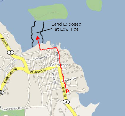
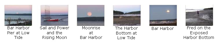
Fred had read somewhere that on the north side of town there is an area of the harbor where the bottom is exposed when the tide is completely out, enabling you to walk across dry land to one of the many islands that dot the area around Bar Harbor. So we walked up Main Street and over to the access street that led down onto the now-dry harbor bottom, and then walked a ways out onto the sandy exposed land. Here, we took a number of pictures, and there are thumbnails for some of them below:
|
You can use the links below to continue on to another album page.
|
Acadia National Park- Day 2 (September 16) |
|
Quebec City, Canada (September 14) |
|
Return to the New England Trip Master Index |