|
Pittsburgh, PA to Nashville, TN (September 20) |
 |
Acadia National Park to Albany, NY (September 18) |
 |
Return to the New England Trip Master Index |
September 19, 2008
New England Trip Day 11
Buffalo and Niagara Falls
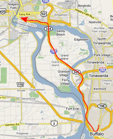
Driving to Buffalo, NY
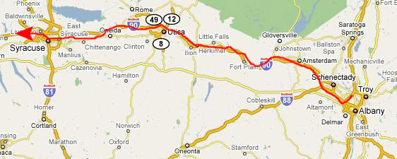
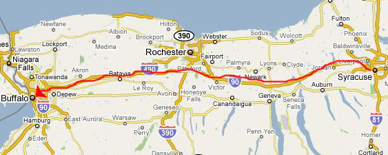
When we got up at the Super 8, we decided to have breakfast across the parking lot at Friendly's- which is something like a northeastern version of IHOP. Then we packed up the car and headed south on I-87 to pick up I-90 west (the New York Thruway).
This route took us through Utica and Syracuse, past Rochester, and on into Buffalo.
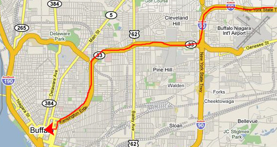
I was kind of impressed that I remembered the way into the center of the city from my last business trip here in 2003. We took I-190 south to Route 33, which is the expressway that goes into the heart of the city. When it ended, we got off on Oak Street and took that south to Broadway, where we turned left and found a parking space. Now we were only three blocks from our first destination here- a store called "Definitely Buffalo."
I Take Fred to "Definitely Buffalo"
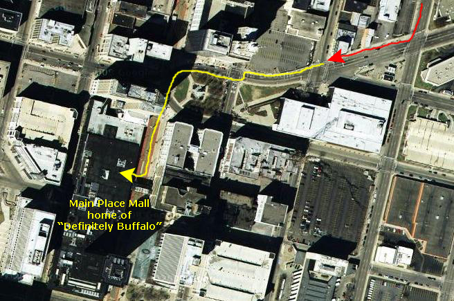
In 2003, when I was here teaching a class here in Buffalo, I went out for a lunch break one day and wandered into Main Place Mall- a downtown shopping mall just across from the building where I was working. I went in intending to find a quick place for some lunch, and I noticed a store named "Definitely Buffalo." At first I thought it would be a store selling Buffalo, NY, souvenirs (for the city, the football team, and such) but I found, to my surprise, that only a third of the merchandise in the store was Buffalo souvenir stuff; all the rest was buffalo-themed stuff. There was oodles of the kind of stuff that Fred and I look for in gift shops and museum stores on our trips- pictures, clothing, china...all kinds of stuff. On my lunch break the second day, I spent the entire hour in the store, loading up on stuff that Fred did not have. I found so many really nice things that I ended up giving it to Fred in dribs and drabs over the next few years (and, truthfully, I have not finished quite yet).
So when we parked the car, we headed up Broadway towards Main Street. Just before we reached Main Street, we passed the
Buffalo War Memorial,
which honors Buffalo's contribution to all four of the major conflicts since the civil war. Just on the other side of the memorial is
Main Street,
which has been turned into a pedestrian mall for about five or six blocks, with the only vehicles using it being the downtown streetcars. Main Place Mall is just to Fred's left, across Main Street.
Since we were here, and were driving a car where the amount of stuff I could carry or check would not be a problem, I wanted to take Fred into "Definitely Buffalo" and let him tell me what of all the stuff they had might fit into his collection. That he did, and we spent the better part of two hours there while
he looked at just about everything
in the store. It was fun watching him make his selections. While he was doing that, I made a movie of the inside of the store, and you can watch that movie here.
While he was shopping, I pored over a map with the proprietress to plan out the route to our next stop today- Niagara Falls.
A Visit to Niagara Falls
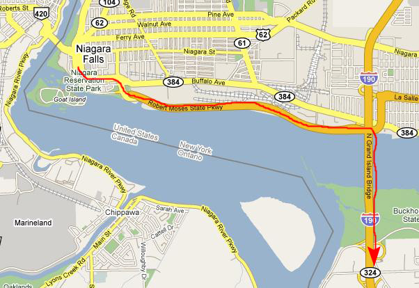
Niagara Falls State Park is about twelve miles northwest of downtown Buffalo, and once the proprietor of "Definitely Buffalo" gave me some pointers, it was pretty easy to get to. A short trip on downtown streets brought us to I-190 North, and we took that across Grand Island to the city of Niagara Falls. The Falls themselves are at the end of a short parkway that splits off from I-190.
We found a parking place quite quickly and just hoofed it over to the park itself. The park is on the southern/eastern side of the Niagara River; the city of Niagara Falls, Ontario, Canada, is on the other side. In some of the pictures of the falls that we took, you can see the city of Niagara Falls, Ontario.
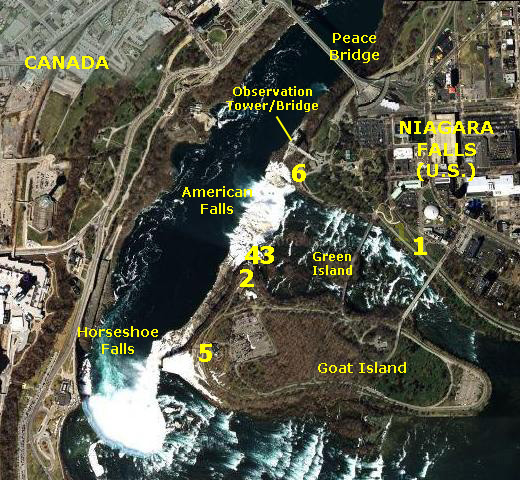
Orientation
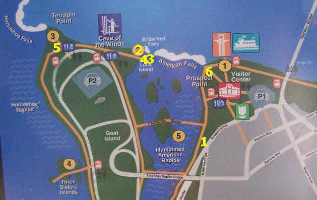
I've grabbed an aerial view of the falls area to show you where the major features are. There really is no "Niagara Falls;" the term just refers to the area itself. The two main sets of falls are the American Falls (which are basically straight) and Horseshoe Falls (curved like a horseshoe). There are two other smaller waterfalls, the largest of which is Bridal Veil Falls, located between Luna Island and Goat Island.
Rainbow Bridge (sometimes called "Peace Bridge") connects Niagara Falls, NY with Niagara Falls, Ontario; had we gotten here very early in the day, we might have gone across it to Canada. But the bridge carries rush-hour traffic and I overheard someone say that it can take as much as 45 minutes to get across, and about the same amount of time back.
I'm going to try to divide up the narrative and pictures into manageable pieces. I'll do my best to tell you where we were relative to the aerial view at right; in some cases, I will put numbers on the aerial view tied to numbers in the sub-headings for this Niagara Falls stop on our trip.
Here is another map (actually a photograph of a park sign) that you might find informative in orienting the photos we've included here:
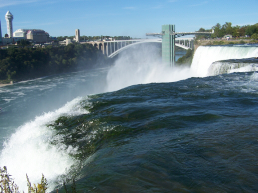
The American Rapids
When we first came over to the park from the car, we walked right up to the shore of the Niagara River at
American Rapids
(#1 on the aerial view and map). Here, we took some pictures of the boiling rapids downstream from the vehicle bridge to Goat Island and upstream of the pedestrian bridge that leads across Green Island to Goat Island.
We took some other views of American Rapids. To see a picture of me, the rapids and the vehicle bridge upstream, please click
here.
To see a picture of the rapids close-up, click
here.
And to see a view of Niagara Falls (Canada) looking down the American Rapids, click
here.
|
I also took a movie while we were here at American Rapids. |
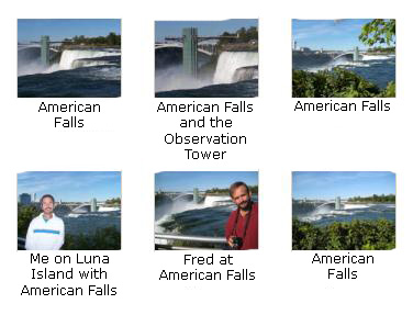
American Falls (Views from Goat Island)
You can look on either map above to see where we are now. We have walked across the
pedestrian bridge
across Green Island to Goat Island, and we have gone up to an overlook that has views down the Niagara River below the falls. One of the most interesting pictures we took from over here is this one of a
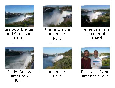
rainbow over American Falls.
We took quite a few other pictures of American Falls from here; please look at as many of them as you wish by clicking on the thumbnail images below:
While we were taking pictures from here, one of the small cruise boats, the
Maid of the Mist IV
came close to the base of American Falls with its load of sightseers. I recall when I was very small and my family came here that we rode on the Maid of the Mist (an earlier incarnation, no doubt) and wore big yellow rain slickers. I also took a movie of American Falls from this vantage point, and you can watch that movie with the player below:
American Falls (Views from Luna Island)
Between us and American Falls is
Luna Island.
From Luna Island you can get more close-up views of American Falls, and you can see Bridal Veil Falls as well. So next we walked down the inclined path and across the pedestrian bridge to Luna Island.
After we crossed the bridge, we went to the corner of the observation area closest to American Falls to take some pictures. (We were at approximately #3 on the map and aerial view above.) Click on the thumbnail images below to see the best of the pictures we took of American Falls from Luna Island:
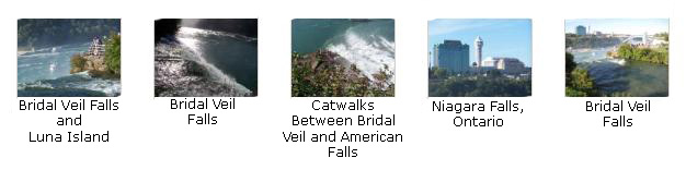
Bridal Veil Falls
Staying in the same observation area, we took some pictures of Bridal Veil Falls and of some of the boats and activity below us on the river. Click on the thumbnail images below to see these pictures:
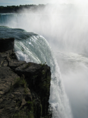
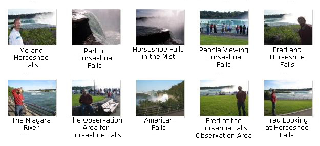
Horseshoe Falls
Horseshoe Falls can be viewed from the other side of Goat Island, so we came back up from Luna Island and walked across to the wide, open area where everyone goes to view Horseshoe Falls (#5 on the map and aerial view). Before we take a look at some of the pictures we took of Horseshoe Falls, you might want to watch the movie I made that pans around 270 degrees at the observation area for Horseshoe Falls, taking in the river, the Falls, the observation platforms and ends by looking down towards American Falls. You can watch that movie with the player below:
|
From the Horseshoe Falls Observation Area |
It is actually something of a shame that we didn't have time to cross the bridge to Canada. Both American Falls and Horseshoe Falls can be viewed head-on from there. On our side, we have to content ourselves with looking across the face of both sets of falls.
There is a very large observation area here- a broad, circular lawn ringed by a fenced walkway that allows views of both sets of falls. It is a great place to wander around or just sit and be mesmerized by the sound of the falls.
Here are some of the best pictures that we took at the observation area for Horseshoe Falls. Please take a look at as many of them as you wish by clicking on their thumbnail images:
|
Before we left Horseshoe Falls, I made one more movie that I think captures the feeling of being by the falls quite well. |
Some Exhibits on Goat Island
When we were leaving Horseshoe Falls, we found a number of exhibits and signs dealing with the history and the technology of Niagara Falls. One interesting thing was that Nikola Tesla was a primary figure in the development of Niagara Falls for power generation, and proved the viability of long-distance AC transmission. There were other interesting pieces of information that we encountered here and elsewhere at the park, so I've gathered all these signs together here. If you will click on the thumbnail images below, you can look at each sign. Most of them are quite readable:

|
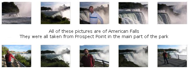
Views of American Falls from Prospect Point
We left Goat Island and walked back across the pedestrian bridge to the main part of the park, and then walked further along the river until we got to Prospect Point (#6 on the map and aerial views), which is an overlook that provides close-up views of American Falls. As at Horseshoe Falls, there were lots of people here taking pictures and such; some of the iconic views of American Falls are taken from here. We took a great many pictures of American Falls from here, and there are clickable thumbnail images below so that you can look at the best of the pictures we took here:
|
While we were here at Prospect Point, I also made a movie of the American Falls. |
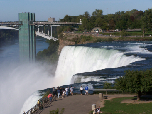
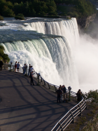
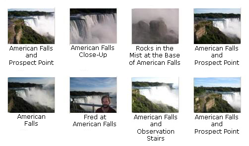
Views of American Falls and Horseshoe Falls from the Observation Tower
There is an observation platform built out over the river canyon, and we went over to see about going out on it. Usually there is a fee, but, for some reason, there wasn't this afternoon. The elevator down to the river was closed, so we could not go down to the base of the falls, so we contented ourselves with some views of both sets of falls from the cantilevered platform. The photo at left is American Falls; if you will click on the thumbnail images below, you can see more pictures of American Falls and some of its detail:
While we were here on the observation platform, I took three movies of note; you can watch them with the players below:
|
I made a panorama movie that shows Niagara Falls, NY, Rainbow (Peace) Bridge, Niagara Falls, Ontario and, of course, both Horseshoe and American Falls. |
|
American Falls Close-Up |
| American Falls |
The Journey Home: Driving to Pittsburgh
Well, that's the last stop on our trip. We have seen and done a great deal, but now it is time to head home. We have two full days of driving ahead of us, and so we are going to try to do as much as we can this evening. We stopped in a restaurant just outside Niagara Falls Park to have an afternoon snack, and then we got back to the car and began the trip home.
We got in the car and found our way back to the Robert Moses Parkway. This took us back to I-190, and we headed south.
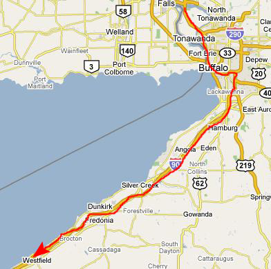
Once on I-190, we just took that south until we got to the interchange with I-90 west. We took I-90 west towards Pennsylvania.
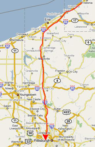
We crossed into Pennsylvania about seven in the evening and continued on down I-90 to Erie, PA. There, we turned south on I-79 which took us all the way to the Pittsburgh area.
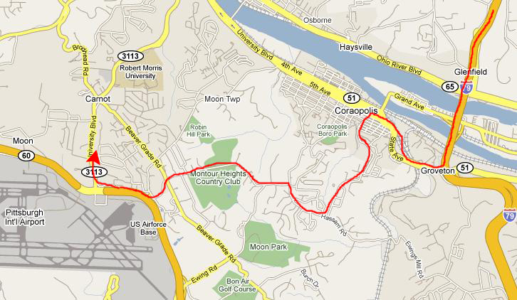
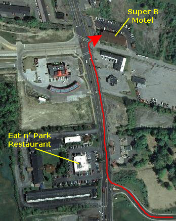
Getting to the motel was quite a chore. It would have been easy had it not been for a good deal of construction all along I-79 and the roads around it. To avoid those problems, the hotel advised that we get off the expressway at Coraopolis, and then work our way through city streets and a couple of residential areas towards Route 60- the major highway that goes to the airport. Fortunately, there were a few signs for the airport that kept us going pretty much the right way.
When we got to Route 60, the hotel was just one exit north at University Blvd. We checked in and then went to a local restaurant called the "Eat 'n' Park" for dinner. This was Friday night, and it seemed as if every high school kid in the county was there, but we got seated right away and most of them left even before we'd been served. Then it was back to the motel and bed.
You can use the links below or continue on to another album page.
|
Pittsburgh, PA to Nashville, TN (September 20) |
|
Acadia National Park to Albany, NY (September 18) |
|
Return to the New England Trip Master Index |