|
December 3, 2008: Gibraltar, UK |
|
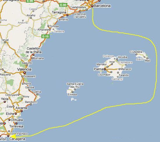
December 1, 2008: Barcelona (Day 4) |
|
Return to the Europe/Cruise Trip Index |
Docking in Cartagena
 |
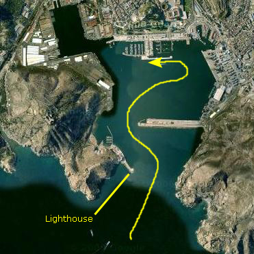
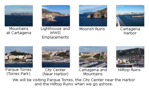
We went up on deck to get some pictures of the docking process and of Cartagena, and then went to get some breakfast and get ready to depart the ship. Fred took some excellent pictures of Cartagena as the ship came into the harbor, and you can click on the thumbnails below to look at these pictures:
Both Fred and I took some pictures of Cartagena and the surrounding area as we came in, and you click on the thumbnail images below to see them:
An Orientation to the City of Cartagena
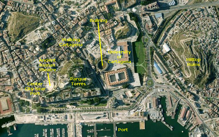 |
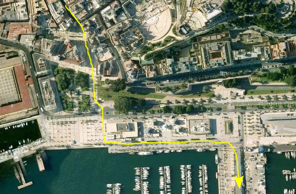
The first part of our walk was to go from the ship up to a long embankment right in front of the harbor area, and from there westward to the area of the city that is immediately adjacent to the port. Here, there are restaurants and shops catering to the tourists and, importantly, the tourist office where we got a lot of information about what to see and do. From here, we walked a short distance to an area of ancient Roman ruins- featuring an actual Roman theatre.
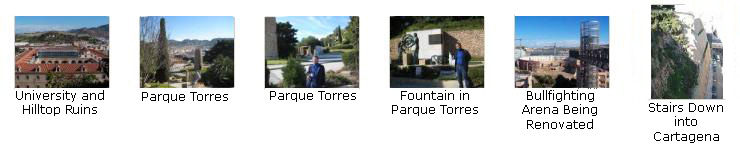
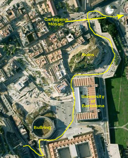
From the Roman theatre, we walked eastward to Parque Torres, the high point here in downtown Cartagena. It offered amazing views of the harbor and the city. Continuing eastward, we descended from the high hill and walked past the Cartagena Bullfighting Arena and through the University of Cartagena. This brought us to the main part of central Cartagena, and we immediately began looking for a way to get to the large ruins on the hilltop to the east of us.
It took us a while, but we finally found out how to access the ruins, and we walked up to them and through and around them. Then we headed back to the center of Cartagena, again going alongside the University, and spent quite a while walking around and admiring and investigating the city. Finally, we walked back through downtown Cartagena and back to the harbor area and to the ship.
Cartagena Port Area
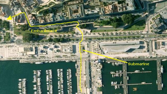 |
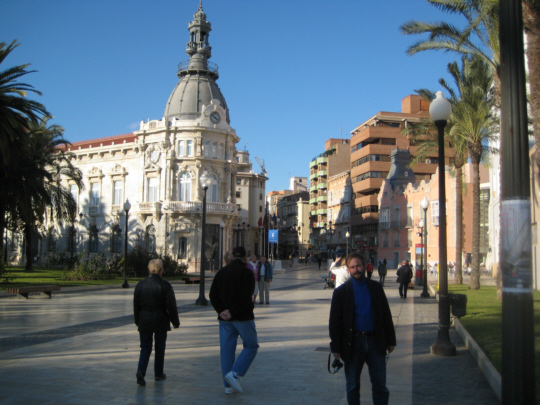
Along the harbor there was a broad esplanade that we had to cross to get to the embankment (or old battlement) in front of a section of the waterfront that was raised one story above grade (probably because it was at the foot of the hill right in the center of town).
Our first destination was the area of the actual city that was near the port; we knew there was a tourist office here and we wanted to check on things to do and places to go.
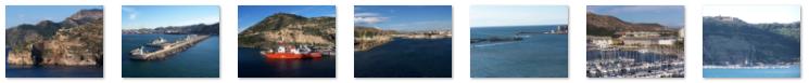
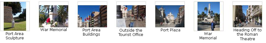
Along our walk, we took a number of good pictures (and you should be able to see where they were taken by matching them to the aerial view). There are thumbnail images for these pictures below, and if you click on them you can see these pictures:
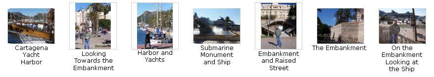
Walking Around Cartagena Near the Port
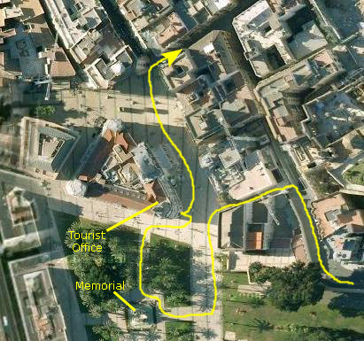 |
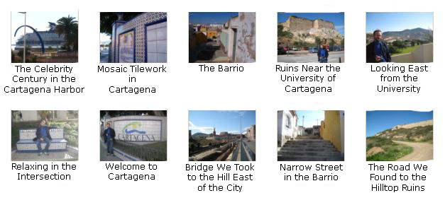
We walked around towards the water to see some of the artwork displayed here, and then around by a monument to Spain's efforts in the Spanish-American War. Then I went into the tourist office and got some directions and guidance. One of the places it was suggested we visit was the Roman Theatre and, as a matter of fact, when we came out of the office, we could see the back wall of the building surrounding the theatre.
I have put some thumbnail images below for other pictures we took while on this part of the route, and if you will click on them you can see these pictures:
The Ruins of an Ancient Roman Theatre
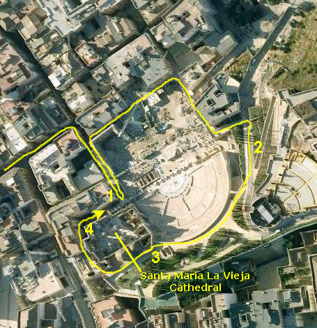 |
The Roman Theatre of Cartagena was built at the end of the 1st Century BC when Cartagena was a Roman colony, in the era of Emperor Augustus. The theatre was not discovered until 1987 and many of the finds are in the Archaeological Museum. The terraced seats were built into the northern side of La Concepcion hill which had been excavated to create seating for 6000. Santa Maria La Vieja Cathedral, the buildings above and behind the theatre, was built in the 13th Century from materials taken from the Roman theatre.
By the sixteenth century, however, the theatre had been lost to fire and its remains built over. Well hidden by the town of Cartagena as it grew over the ruins, it was not discovered again until 1987. The town was asked to vote as to whether or not the buildings standing there in 1987 should remain, or be torn down to find the ruins. The town voted in favor of the excavation and reconstruction of the Roman Theatre.
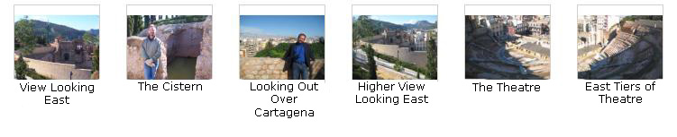
When we tried to enter the gate, we were met by one of the city tour guides; she indicated that to actually enter the theatre itself, you had to sign up for an official tour (this so they could control the number of people climbing over the delicate ruins). We didn't have time for that, so she directed us to another entry to Parque Torres that would allow us to get up and around the theatre for good pictures. So we walked back down through a couple of more side streets and then entered Parque Torres by one of its gates and came around to the east side of the theatre (Point #2) on the aerial view. From here, we had excellent views of the theatre looking up across the seats to the back of it. I have put thumbnail images below for the pictures we took of the theatre from here, and you can click on these images to view the pictures:
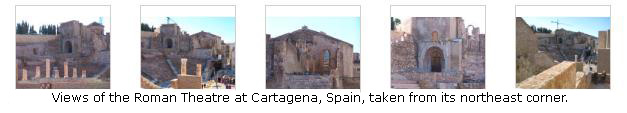
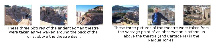
Next, we walked around and above the theatre towards point #3 on the aerial view, taking pictures as we went. There were a couple of levels of walkway, and we went up and down to get good views- such as this closeup of the columns at the northeast corner of the theatre (these being reconstructed from fragments found in the excavation). As we came around to the old cathedral, we found an ancient cistern that presumably held water for either the church or the theatre. The thumbnail images for these pictures are below:
From our vantage point at #3, we could see most of the ruins of the Santa Maria La Vieja Cathedral, and we walked around the western side of the cathedral past the outer wall (the one we saw from the tourist office) which is still standing. This brought us back around to a narrow street on the north side of the cathedral ruins, and we could look past the gate area where we first tried to enter the theatre and east across the theatre stage.
We are done here at the Roman theatre, and so we have walked back up around the back of the theatre itself so we can head eastward towards Parque Torres. Here is an excellent picture of Fred and Parque Torres in the background. To end our visit to the Roman theatre, we've saved some of the best pictures for last. Use the thumbnail images below to look at them:
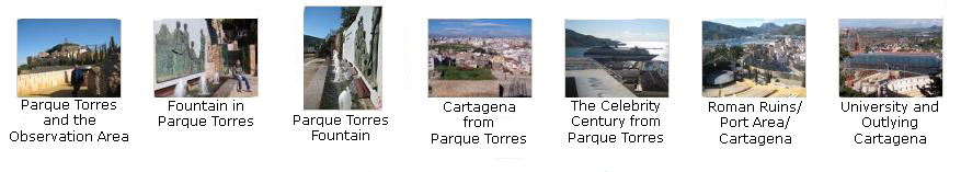
Cartagena's Parque Torres (Torres Park)
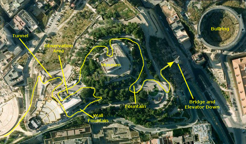 |
Then we went through a gate and up some steps through the trees and out onto the broad observation area here on the peak. There were wonderful views all across Cartagena, including the harbor, downtown, the Roman theatre and other areas of the city. You can also see plainly that there are old ruins dotting the area- ruins that have been left undeveloped.
From the observation area, we walked around north of the museum (going up temporarily to see what was there), and then around to the south side of the peak. Here, we took pictures of another fountain and of a tall brick structure (a storehouse, I think). We could also look eastward at the University of Barcelona, the Barcelona Bull Ring (currently under reconstruction, although in the aerial view you can see it before the work was undertaken) and towards the ruins on the hilltop to the east that we wanted to get to next.
Finally, we walked down around that structure and along a walkway above the street here on the east side of the hill. On this side, the drop-off was quite steep, and there were two ways to get down to street level again. One was to take a narrow path down a steep set of stairs cut into the cliff face. But this route seemed to be closed, and we had to take the newer method which was to cross a footbridge over the street to a tower that contained an elevator and spiral staircase around it. I wanted to go down the stairs, but they were closed, so we took the elevator.
Below are thumbnail images for the many good pictures we took here in Parque Torres, and you can click on them to view the full-size images:
|
|
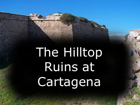
Walking Through Some Ruins on a Hill Near the Port
Getting to the Hilltop Ruins
 |
 |
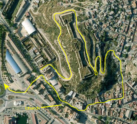
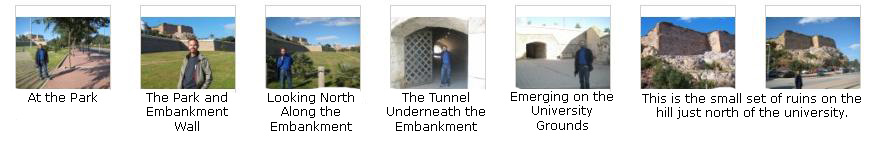
We crossed the street and went around by the Cartagena Bull Ring (which was under construction when we were here but looks different in the aerial views) and over to the university. We thought we might go through the library building to the street, but there was no exit, so we came back out to the front (where we spotted an interesting archway, although I had no idea if it was actually old or just made to look that way). We walked around the north side of the large building and from there over to the street that ran beside what appeared to be a park or a large grassy area. As we came by some old cannon, we realized that this raised area must have been part of the old city, raised up for defense.
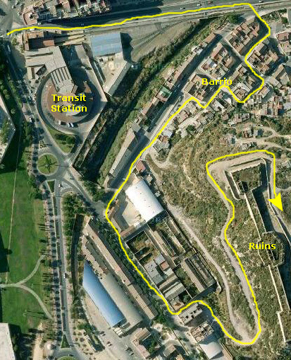
We walked north along that street and past another set of hilltop ruins to another overlook. From here, we could see the transit station and we could approximate a route that would take us over to the large set of ruins we wanted to explore. The street brought us around and down again, past another interesting mural, to what seemed to be a major intersection. We'll be back this way so I won't say more about it now. We walked along the sidewalk on the south side of the traffic circle past some very pretty mosaic work and then headed east along a major street that crossed a long bridge heading toward the hilltop ruins.
At the end of the bridge, we turned right off the major street and made out way up the hillside towards the ruins. We had no idea which of the narrow streets and stairs might take us up there through what appeared to be a relatively low-class barrio. We got a little concerned that we were getting too far off the beaten path, so we turned west and followed another more well-traveled street in that direction. We didn't know it then, since we had no aerial view to go by, but we could have just gone another short distance and come out onto a road up to the ruins.
Instead, we walked to another street and turned southeast walking along a commercial street which seemed to parallel the hill on which the ruins were located. Finally, we came to an alley and we could see the hill at the end of it, so I thought we might just as well go cross-country to get up there. As it turned out, at the end of the alley we found ourselves at the beginning of a dirt road that led right up to the ruins. We were able to follow it with no problem, and eventually found ourselves right where we wanted to be.
Below are thumbnail images for pictures of the things we saw getting over to ruins, many of which were referred to in the narrative just above. Click on these thumbnails to view the full-size pictures:
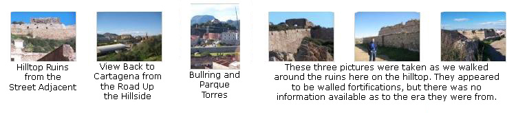
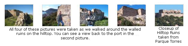
Walking Through the Hilltop Ruins
 |
|
To view the slideshow, just click on the image at right and I will open the slideshow in a new window. In the slideshow, you can use the little arrows in the lower corners of each image to move from one to the next, and the index numbers in the upper left of each image will tell you where you are in the series. When you are finished looking at the pictures, just close the popup window.
Here is a final section of pictures that summarize what we saw here; click on the thumbnail images to view:
|
|
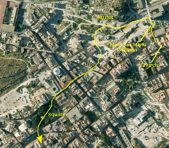
Getting Back to the Center of Cartagena
And then we were back to the parkland near the University of Cartagena.
Walking Through Cartagena
Past the University and Ruins
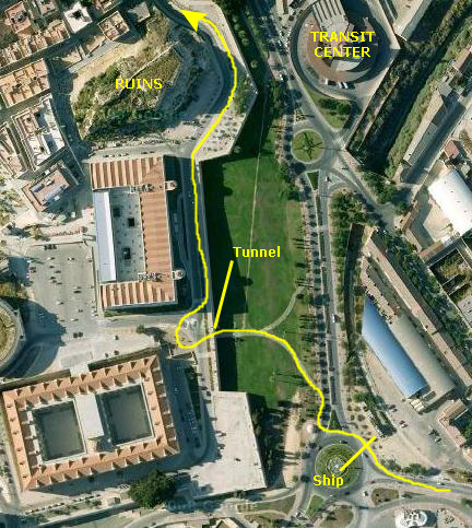 |
We walked north and followed our previous path around the overlook where the cannon were, and past the small set of ruins on the hill just north of the University. Then, once again, we followed the street down into the city itself.
Below are some thumbnail images for some additional pictures that we took on this part of our walk; these pictures follow the path that we took (shown on the aerial view). If you click on the thumbnail images you can view the full-size pictures:
Downtown and Museum
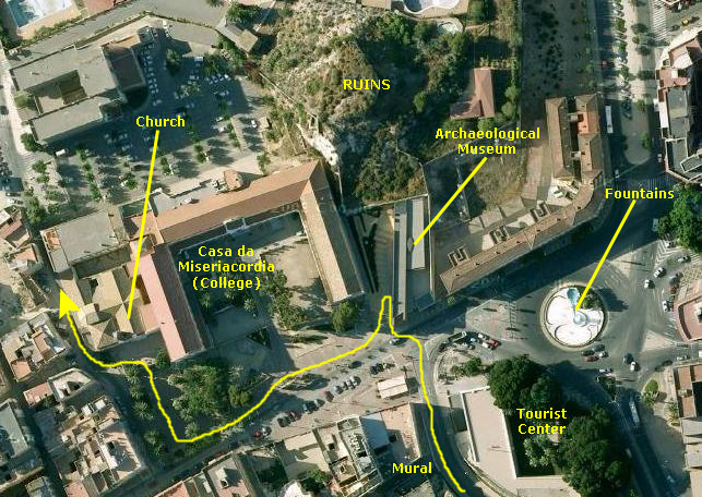 |
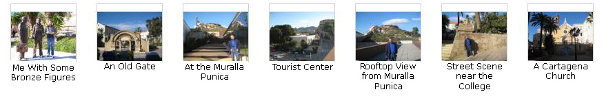
This museum is entirely devoted to housing a section of the original Punic wall dating back to shortly after the city was founded by the Carthaginian general Hasdrubal in 227 BC. Cartagena and its wall stood against the invading Roman general Scipio during the Punic Wars some decades later. The building, which is beautifully constructed in tones of rust and brown tile, incorporates a walkway above what remains of the wall for a revealing view of how it was constructed. From this vantage point, the lines of two parallel rows of large sandstone blocks are clearly visible, with smaller walls at right-angles creating a series of chambers and passages. These were intended to befuddle any soldiers who had managed to break through the outer layer. It's a Hellenistic design, one that was used throughout the Mediterranean - but this is the sole remaining example in Spain.
A further stairway takes you on to the roof of the museum, which is built to the wall's original height. The view of the adjacent hills of Cartagena (some with fortresses from later periods) and the plains gives an exhilarating sense of how the city's fortifications held together. The silhouette traced in ancient stones beneath your feet suddenly becomes a real wall. From this rooftop, we took a number of good pictures. One of them looks back beyond the transit center to the fortress ruins we just toured, and another looks just a few feet further north towards another small set of ruins on a hill just north of the museum. The museum actually backs right up to this hill.
From here, we could also get a good look at the (now empty) fountains in the middle of the traffic circle adjacent, and we could also look down the street (in the direction we would walk) towards the area around the port. When we descended from the museum's rooftop, we walked along this street past two sets of bronze figures and the remains of an old gate (only a few hundred years old. Then it was past the College da Misericordia and the church adjacent to it. At the church, we turned north again, heading to another hill and more ruins that we could see a block or two away.
Below are some thumbnails for additional pictures taken on this part of our walk; click on them to view the full-size images:
|
|
Walking Back Through the City Towards the Port
 |
We walked through a site that looked as if there was some new construction going on, and reached the city streets again. We were able to look at some typical downtown residences as we passed. At one point, we came out into a fairly large plaza that was lined with residences. There were a couple of statues and a fountain or two in the shady plaza. We were back into the downtown streets and heading towards the port. You can see a couple of typical streets scenes here and here.
Back in the Area Around the Port
 |
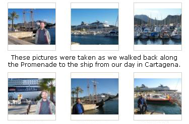
We got another view of the War Memorial, and we walked out to the promenade, preparing to walk back to the ship.
Right at the edge of the harbor, we ran across an interesting obelisk. Instead of being a solid piece, it was sliced in the middle and four round, polished marble spheres had been placed on the bottom portion, with the top portion sitting on them. Take a look at a closeup view and you'll see what I mean.
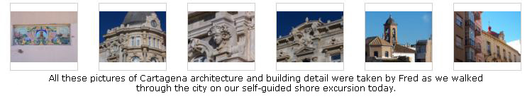
We have about an hour before the ship sails, so it's time to walk down the promenade and reboard. But, before we do, you might be interested in seeing a few final pictures that Fred took from our day-long walk here in Cartagena. As always, he is very interested in architecture and architectural detail, so click on the thumbnail images below and look at a few of the many good pictures he took here in Cartagena:
Returning to the Ship
 |
We boarded the ship in plenty of time and went immediately to the Islands Cafe and the Poolside Grill for a snack.
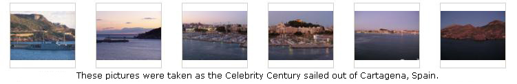
We Sail From Cartagena
You can use the links below to go to another photo album page.
|
December 3, 2008: Gibraltar, UK |
|
December 1, 2008: Barcelona (Day 4) |
|
Return to the Europe/Cruise Trip Index |