


|
June 20, 2009: New Mexico Trip Day 4 |
|
June 18, 2009: New Mexico Trip Day 2 |
|
Return to the Index for Our New Mexico Trip |
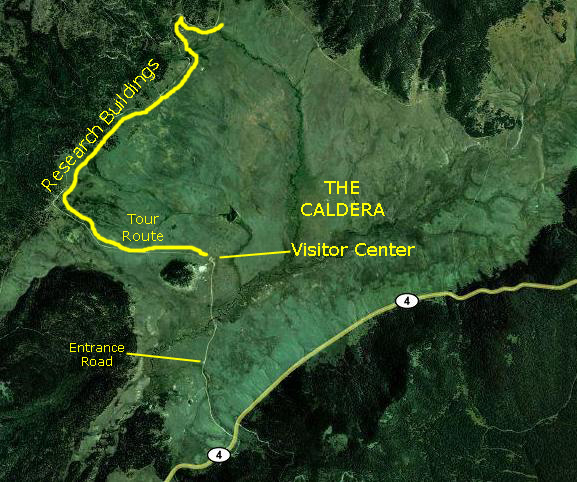
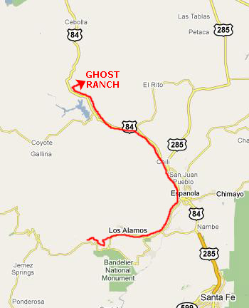
On the Jemez Mountain Trail: Driving to Jemez Falls
We were up and had the campsite struck by about nine-thirty, and headed out of Bandelier back west on New Mexico Highway 4, heading towards the Jemez Falls trailhead.
 At the Las Conchas Fishing Access |
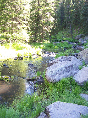
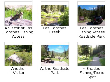
We next stopped at what we thought might be the trailhead for a hike that we had not done, but found that it was basically just a picnic/fishing area for Las Conchas Creek. Although the creek looked a bit too small, I can only suppose that there is some fishing here. But there was no hiking, so we just took a few pictures before heading on towards Jemez Falls. I have put thumbnail images for some of these below; click on them to view the full-size pictures:
|
After spending just a bit of time here, we got back in the RAV4 and headed east along Highway 4 towards the Jemez Falls Campground and trailhead.
On the Jemez Mountain Trail: Hiking to Jemez Falls
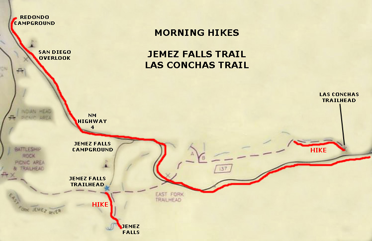 Diagram of This Morning's Hikes |
We also wanted to check out the San Antonio Hot Springs, but we were going to have to stop somewhere to ask about them.
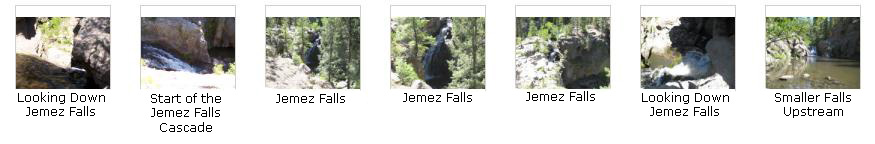
We also thought that we might do more of a hike that we had done once before- the Las Conchas Trail. But our first stop would be for Jemez Falls. We continued eastward on Highway 4 until we came to the entrance for the Jemez Falls Campground. The trailhead for the Jemez Falls trail is at the end of the campground area. We drove in, parked, and set off on our hike down to the falls.
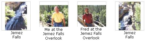
The hike along the Jemez Falls Trail is a relatively short one- only about half a mile to the falls. There is a nice overlook for Jemez Falls, and you can also climb down nearer the falls to get a better look. A bit upstream from the large falls is another small set of falls, and we went off to investigate those, too.
|
Then we went climbing around near the falls. Both Fred and I went down to the top of the rocks above the main falls, coming around from behind them. (There, we found a couple of fishermen angling in the stream above the falls.) We got some views looking down the falls. We also walked along the stream for a ways heading upstream until we came to the second, 10-foot set of falls. Finally, we got some more pictures of the main falls as we headed back up to the overlook. I've put thumbnails for some of these pictures below; click on them to view the full-size images:
|
I also made a movie of Jemez Falls and you can watch that movie with the player below:
|
This movie of Jemez Falls was made from the overlook at the bottom of the trail. |
On the Jemez Mountain Trail: The Las Conchas Trail
Diagram of This Morning's Hikes |
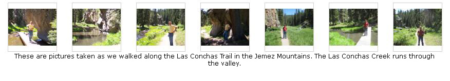
We left the Redondo Campground and headed back west on Highway 4. We knew we wanted to stop at Valle Grande, but we came across the Las Conchas Trail first, so we stopped to walk along it for a ways.
The parking area for the Las Conchas Trail is located in a beautiful valley that has a gentle stream running through it. On the south side of the road there is a private residence/farm, and there were some horses grazing by Las Conchas Creek in the verdant meadow; the trail begins on the north side. This is a popular spot for a number of reasons, and it is usually hard to find a place to park. Today was unusually busy, and shortly after starting out from the trailhead, we found out why.
In addition to the normal complement of hikers, two other activities were going on. The first was some sort of group doing rock climbing and rapelling on the face of a 100‑foot cliff quite near the beginning of the trail. Fred took a picture of the rock climbers, who seemed to be kids under the supervision of five or six adults. They had all the equipment needed, and appeared to be using pitons that had already been driven into the cliff face. Watch Fred's movie of them using the player below:
|
Climbing Kids Fred took this movie of the kids who were rock climbing, and he also took in the creek and surrounding scenery. |
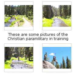
The other group, which was much larger, seemed at first to be some sort of Boy Scout troop, but on closer look they were wearing uniforms that looked much more like Army uniforms than scout paraphernalia. And there seemed to be quite a few of them- from teen-agers up through twentysomethings- and all male. They were practicing all kinds of trail skills- such as building rope bridges across the stream and erecting zip lines. You can watch my movie of some of them using the zip line using the player below:
|
Paramilitary Zipliners The zipliners might be hard to see; they are coming from the top of the rock at the right of the picture, and using the zip line to cross Las Conchas Creek. |
Actually, they seemed so much like a military group that I found myself thinking that the only thing that was missing were weapons.
|
The fellow seemed quite proud of his patches and insignia, one of which he explained was similar to, but not the same as, the patch worn by Special Forces members in the US Army. One other patch identified him as Church member, although which Church, exactly, wasn't clear. He seemed very much in earnest, and not at all antagonistic. His attitude seemed to be that he would have been surprised to learn that not all Christians were making the same kind of preparations as was his own group. As I said, I found the explanation as unsettling as the presence of these paramilitary people on the beautiful trail, and I walked away unavoidably humming "Onward Christian Soldiers" to myself.
When we got back to the trailhead, it was lunchtime, so we made sandwiches and drinks and sat underneath some pine trees near the beginning of the trail to eat. While we were doing so, I took a picture of Fred eating lunch and he took a picture of me.
We have been on this trail before; the last time, we went much further than we did today, but it was a pleasant walk in the warm morning sun. Below are some thumbnail images for the best of the pictures we took today along the Las Conchas Trail. Click on them to view the full-size images:
|
|
Here is a movie of the peaceful valley through which the Las Conchas Creek flows and the trail parallels. |
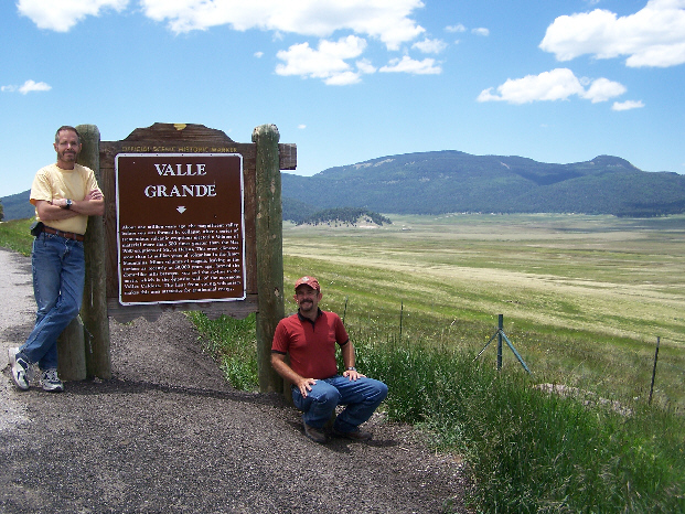
On the Jemez Mountain Trail: Valles Caldera National Preserve
|
A nine-member board of trustees is responsible for the protection and development of the Valles Caldera National Preserve. Seven of its members are appointed by the President of the United States. In addition, the current Superintendent of nearby Bandelier National Monument and the Forest Supervisor of the Santa Fe National Forest also serve on the board. All board decisions are made in public meetings.
In August of 2002, the management authority for the new piece of public land was transferred to the Valles Caldera Trust. With the prospect of the opportunities presented by a blank slate, the board began its work. This work includes continuing ranch operations while opening the preserve to visitors. The Trust is using science-based adaptive management to inform its management and make decisions on the preserve.
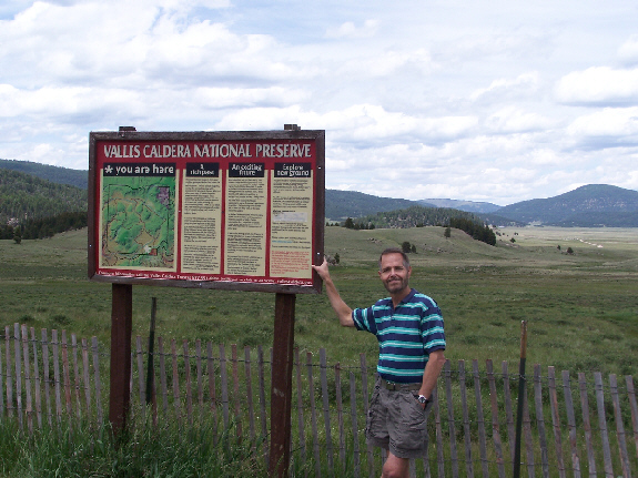
Today, the Valles Caldera National Preserve and the Valles Caldera Trust are still works in progress. With a small but creative staff, they�re working to find ways to meaningfully include the public in the development of our programs and planning. One of the things they do is allow visitors to come into the caldera and learn more about the operation of these public lands. That's what we planned to do today. We'd driven by here a number of times; this will be the first time we have actually entered the caldera.
|
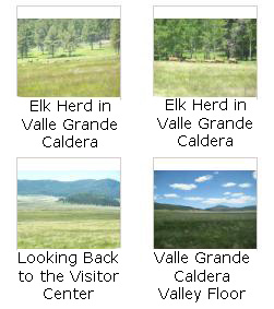
No sooner had we arrived at the Visitor Center than one of the staff asked us if we wanted to go on the next 45-minute tour; she was ready to go and we could join another couple if we wished. So we quickly bought two tickets, piled into her van, and she headed off down the dirt road heading north to the valley wall. On the way across the valley floor, we got some good views of the caldera and some of the elk that call Valle Grande home. You can have a look at these pictures if you click on the thumbnail images below:
|
The ride around the caldera with our guide was certainly interesting, and she took time to explain quite a bit about the history, the ecology and the management of the caldera.
|
Here is a movie that I made of our guide explaining the geology and history of the caldera. It was typical of the running commentary that she gave us as we drove through the valley. |
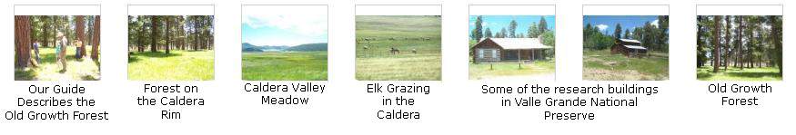
As we drove around, and when we stopped at a point on the caldera wall where we were in old growth forest, Fred and I took a good many pictures. Thumbnail images for some of the best of them are below. Have a look at them by clicking on those thumbnails:
|
We returned to the small visitor center about an hour later, and Fred and I headed off back up to Highway 4. If you will look again at the aerial view above, you will see that in the bottom of the valley there is an area that is wetter than the rest of the valley, and is, perhaps, a shallow creek that flows all the time; today there was a good deal of water. We stopped the car right at the small bridge that crosses this area.
|
Here is a movie that will give you a 360-degree panorama of the entire caldera, taken from this lowest point in the valley. |
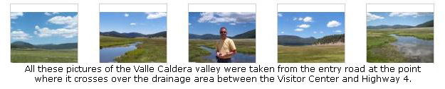
We also took five more good pictures from this point on this beautiful afternoon, and if you will click on the thumbnail images below, you can see the full-size pictures:
|
|
"About one million years ago, the magnificent valley before you was formed by collapse, after a series of tremendous volcanic eruptions ejected a volume of material more than 500 times greater than the May 1980 eruptions of Mt. St. Helens. This event climaxed more than 13 million years of volcanism in the Jemez Mountains. Minor volumes of magma, leaking to the surface as recently as 50,000 years ago, formed the dome-like hills between you and the skyline to the north, which is the opposite wall of the enormous Valles Caldera. the heat from young volcanism makes this area attractive for geothermal energy."
|
While we were on the roadside above the caldera, I took one last movie of the beautiful panorama of the Valles Grande Caldera. |
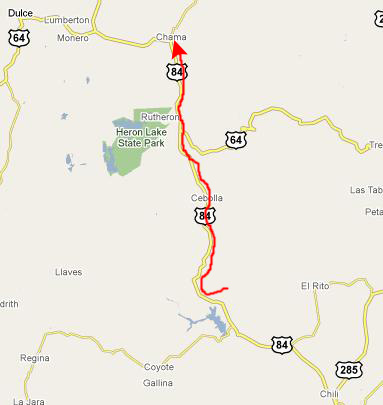
Now we were done for today in the Jemez Mountains, so we headed off towards Chama, New Mexico.
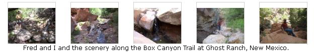
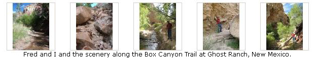
At Ghost Ranch: The Box Canyon Trail
 |
|
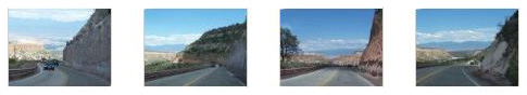
The road began to level off into Espanola, where we stopped for gas and some frozen yogurt. Then we were on US Highway 84 heading north from Espanola. Click on the thumbnails below to see some images of this part of the drive:
|
With Fred driving now, we continued north, and the terrain changed to stark red cliffs. I took some pictures of the passing scenery, and you can click the thumbnails below to view them:
|
I had just finished taking those last pictures when we passed a roadside visitor center for Ghost Ranch, a place Fred had seen mentioned on the Internet when he was doing the planning for this trip. We made a U-turn and went into the Visitor Center to get some information. We found out that there were some good hikes we could do on Ghost Ranch, which is nominally a Presbyterian Retreat and Conference Center but used by all kinds of groups throughout the year. The couple at the Visitor Center told us about a couple of hikes. The only request that Ghost Ranch seemed to make was that we check in at the main office on the ranch to let them know that we would be doing one hike or another. This was just for safety's sake, we were told, and it seemed a prudent thing to do. So we left the Visitor Center and backtracked about two miles to the actual entrance to the ranch, drove in and found the office without any trouble. We wouldn't have taken a picture of the office but for the beautiful painted horse statue that stood out front.
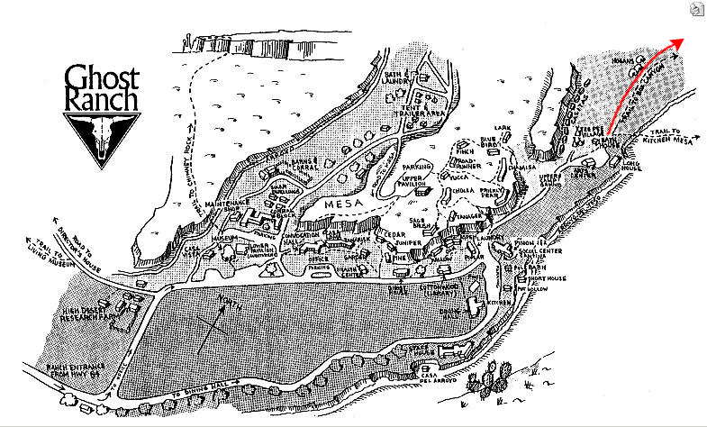 |
As you can see on the diagram at right, to get to the Box Canyon Trail we had to drive through the ranch to the extreme northeast corner. There, we found a place to park the car and followed the signs for the Box Canyon Trail. This place reminded me somewhat of Montreat, another Presbyterian conference center that was also surrounded by mountains and a few good marked trails. Of course, that was in the Appalachians- a much different ecosystem than here in the high desert.
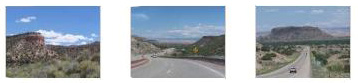
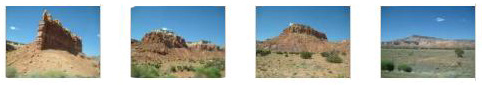
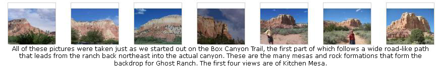
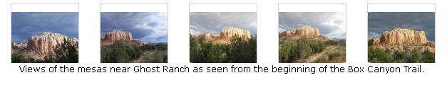
For the first part of the trail, we followed a wide path- almost a road- and we did see some evidence that vehicles had driven along it for a half-mile or so. But then the wide path ended and the actual trail began. Along this first part of the trail, the views were mostly of the surrounding mesas including one, Kitchen Mesa, that had its own five-mile trail up to the top. One of these days we will have to do that trail. So this first collection of pictures is all from the first half-mile of the Box Canyon trail; click on the thumbnail images below to have a look at the pictures:
|
|
Here is a movie of the two of us starting out on the Box Canyon Trail here at Ghost Ranch, New Mexico. |
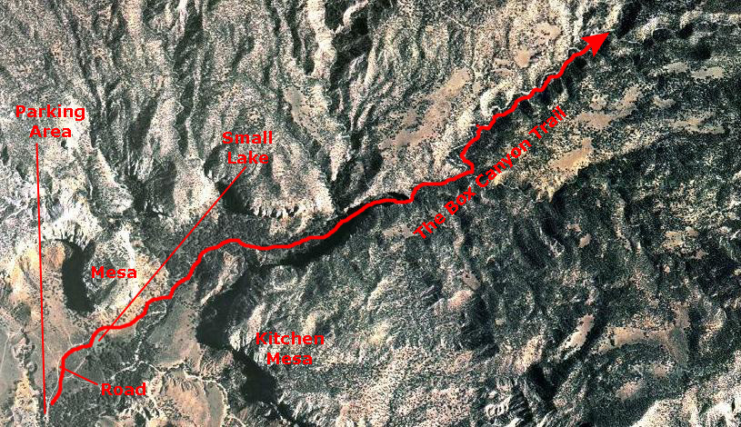
I think it might be interesting for you to see an aerial view of the area covered by the Box Canyon Trail, so, courtesy of Google Maps, I have put one below. The resolution out here in the middle of nowhere is not that great, so this is as far as I zoomed in. I have marked some of the landmarks for you.
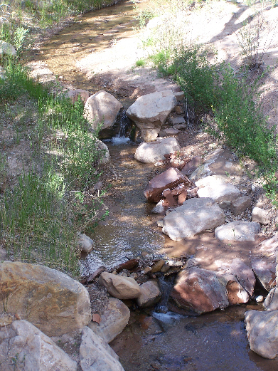 |
After about a mile, we came to a junction where two streams came together. We bypassed the side rivulet and continued up the main (or what we thought was the main) stream. At one point, we had to climb over a large rock to continue the trail; previous hikers had thoughtfully attached a knotted rope to the top of the rock, so you could pull yourself up and let yourself down.
I supposed we walked a mile and a half along the stream before it pretty much petered out. I would imagine that had we continued up the canyon we would eventually have had to start ascending steeply up the side of the mesa at the rear of the canyon, but we decided we'd seen the best and we retraced our path to the point where the side stream came in. We went up that side stream just fifty or a hundred feet before it, too, got too small to be of interest. I took a movie of the tiny waterfall up this side stream, and you can watch that movie using the player below:
|
|
Below are some thumbnail images for more of the pictures we took along the Box Canyon Trail. Click on those thumbnails to view the full-size pictures:
|
|
When we got back to the beginning of the trail, we took a bit of a wrong turn, and found ourselves going back a slightly different way, and we saw a small lake that we hadn't seen before. It would seem, we thought, that this is where the water going through the aqueduct ended up, but we didn't investigate to make sure. As we were walking back to the vehicle, we took some more pictures of the surrounding mesas in the early evening light. You can compare these with the ones taken earlier when the sun was much higher. Click on the thumbnail images below to view the full-size images:
|
|
|
We got back in the vehicle and drove back out the entrance road to the ranch. Just before reaching the highway, we got a good view of the Abiquiu Reservoir across on the west side of the highway. When we got to the highway, we turned north for our drive to Chama.
Driving to Chama, New Mexico
 |
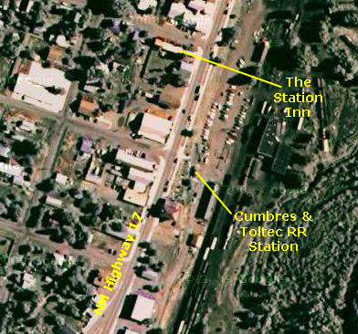
We had reservations at a small local place called the Station Inn. It was a nice room- almost like a B&B. It had the virtue of being right across the street from the Cumbres & Toltec Scenic Railway that we would be riding tomorrow. When we got settled in the room, I got out the blender and made us some frozen drinks. You can see me at work here. It was a nice ending to an energetic day.
We got a recommendation from the woman at the front desk and had dinner at the High Country Restaurant about two miles south of the Inn on NM 17. We came back to the Inn, walked around town for a while to scope out where we would go tomorrow, and then turned in.
You can return to the page index
or use the links below to go to another album page.
|
June 20, 2009: New Mexico Trip Day 4 |
|
June 18, 2009: New Mexico Trip Day 2 |
|
Return to the Index for Our New Mexico Trip |