|
November 9, 2009: Panama City, Panama |
|
November 7, 2009: A Sea Day |
|
Return to the Index for Our Panama Canal Cruise |
Today (actually, "today" began about 4AM) will be devoted entirely to our transit of the Panama Canal. Although the average transit time for a vessel is just under 30 hours, we will be doing it in about half that time; passenger ships are given precedence through the locks. (The other thing that brings the average up is that many ships arrive at the Canal without a "reservation," and they are likely to be sidelined at some point during their transit.) Before we begin this significant event, I think it might be a good idea to give you some background on the canal. So, we'll first cover a bit of history, and then we'll describe the canal itself. Finally, in a series of sections, we'll go through it together.
The Evelyn Wood History of the Panama Canal
Theodore Roosevelt, who became president of the United States in 1901, believed that a U.S.-controlled canal across Central America was a vital strategic interest to the U.S. This idea gained wide impetus following the destruction of the battleship USS Maine, in Cuba, on February 15, 1898. The USS Oregon, a battleship stationed in San Francisco, was dispatched to take her place, but the voyage — around Cape Horn — took 67 days. Although she arrived in time to join in the Battle of Santiago Bay, the voyage would have taken just three weeks via Panama.
Roosevelt was able to push through the acquisition of the French Panama Canal effort. Panama was then part of Colombia, so Roosevelt opened negotiations with the Colombians to obtain the necessary rights. In early 1903, the Hay-Herran Treaty was signed by both nations, but the Colombian Senate failed to ratify the treaty. In a controversial move, Roosevelt implied to Panamanian rebels that if they revolted, the U.S. Navy would assist their cause for independence. Panama proceeded to proclaim its independence on November 3, 1903, and the USS Nashville in local waters impeded any interference from Colombia. The victorious Panamanians returned the favor to Roosevelt by allowing the United States control of the Panama Canal Zone on February 23, 1904, for US$10 million.
The Americans inherited a small workforce, but also a great jumble of buildings, infrastructure and equipment, much of which had been the victim of fifteen years of neglect, but much of which was put to good use by the Americans throughout their construction effort. A new chief engineer arrived on the isthmus on July 26, 1905. He set to upgrading the railway, improving sanitation in the cities of Panamá and Colón, remodelling all of the old French buildings, and building hundreds of new ones to provide housing. He then undertook the task of recruiting the huge labor force required for the building of the canal.
|
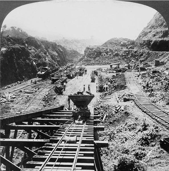
By August 1907, 1,000,000 cubic yards per month was being excavated; at the peak of productivity, 3,000,000 cubic yards were being excavated per month. The scale of the work at the Gailliard Cut was massive: six thousand men worked in the cut, drilling holes in which were placed a total of 60,000,000 lb. of dynamite to break up the rock, which was then taken away by as many as 160 trains in a day. On May 20, 1913, steam shovels made a passage through the Culebra Cut at the level of the canal bottom. Dry excavation ended on September 10, 1913.
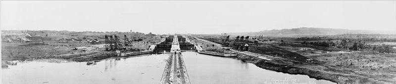
Two artificial lakes form key parts of the canal; Lake Gatun and Miraflores Lake. Four dams were constructed to create these lakes. By far the largest of the dams, and by far the most demanding, was the Gatun Dam, which created and impounds Lake Gatun. This huge earthen dam, which is 2,100 ft. thick at the base and 7,546 ft. long along the top, was the largest of its kind in the world when the canal opened.
The project of building the locks began with the first concrete laid at Gatun, on August 24, 1909. The Pacific-side locks were finished first; the single flight at Pedro Miguel in 1911 and Miraflores in May 1913. The seagoing tug Gatun, an Atlantic entrance working tug used for hauling barges, had the honor on September 26, 1913, of making the first trial lockage of Gatun Locks.
On October 10, 1913, the dike at Gamboa, which had kept the Culebra Cut isolated from Gatun Lake, was demolished; the initial detonation was set off telegraphically by President Woodrow Wilson in Washington. On January 7, 1914, the Alexandre La Valley, an old French crane boat, became the first ship to make a complete transit of the Panama Canal under its own steam, having worked its way across in the final stages of construction.
The Panama Canal cost the United States around $375,000,000, including the $10,000,000 paid to Panama and the $40,000,000 paid to the French company. It was the single most expensive construction project in United States history to that time; remarkably, however, it was actually some $23,000,000 below the 1907 estimate, in spite of landslides and an increase in the canal's width. An additional $12,000,000 was spent on fortifications. More than 75,000 men and women worked on the project in total; at the height of construction, there were 40,000 workers working on it. According to hospital records, 5,609 workers died from disease and accidents during the American construction era. A total of 238,845,582 cu. yd. of material was excavated in the American effort, including the approach channels at both ends of the canal.
How the Panama Canal Works
|
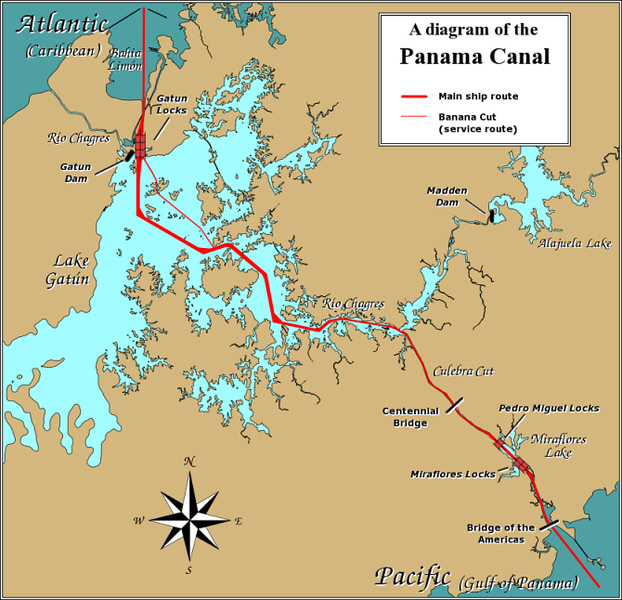
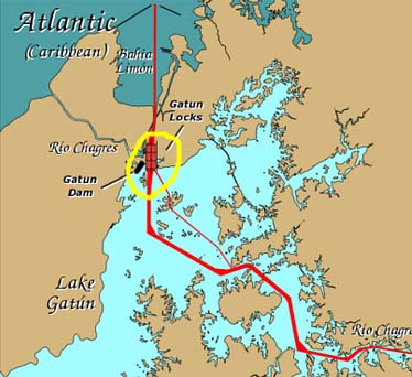
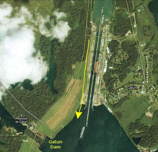
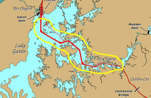
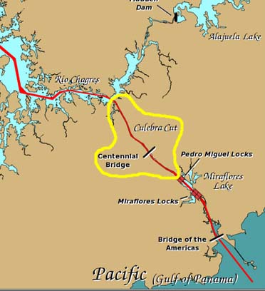
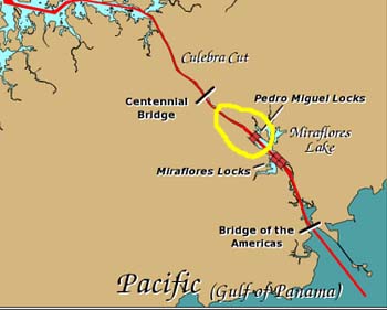
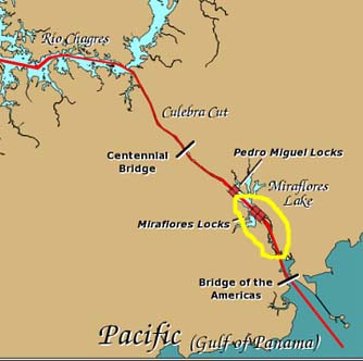
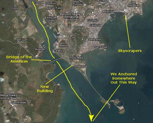
At left is a map of the entire Panama Canal. I am going to be using portions of this map later to show you where we were when we took our pictures during our transit of the canal. For now, you can mentally divide the canal transit into seven portions:
|
I'll repeat the appropriate sections of this map as we proceed through the canal. Now let's take a look at the major elements of this engineering marvel.
Design
The lock chambers are 110 ft. wide and 1050 ft. long, with a usable length of 1000 ft. These dimensions determine the maximum size of ships which can use the canal. The lock chambers are massive concrete structures. The side walls are from 45 to 55 feet thick at the bases; towards the top, where less strength is required, they taper down in steps to 8 ft. The center wall between the chambers is 60 ft. thick, and houses three long galleries which run the full length of the center wall. The lowest of these is a drainage tunnel; above this is a gallery for electrical cabling; and towards the top is a passageway which allows operators to gain access to the lock machinery.
Filling and Draining
|
The gates which separate the chambers in each flight of locks must hold back a considerable weight of water, and must be both reliable and strong enough to withstand accidents, as the failure of a gate could unleash a catastrophic flood of water downstream. These gates are of enormous size, ranging from 47 to 82 ft. high, depending on position, and are 7 ft. thick; the tallest gates are required at Miraflores, due to the large tidal range there. Each gate has two leaves, 65 ft. wide, which close to a V shape with the point upstream; this arrangement means that the force of water pushes the ends of the gates together firmly. The heaviest leaves weigh 662 tons; the hinges themselves each weigh 17 tons.
The original gate machinery consisted of a huge drive wheel, powered by an electric motor, to which was attached a connecting rod, which in turn attached to the middle of the gate. These mechanisms were replaced with hydraulic struts beginning in January 1998, after 84 years of service. The gates are hollow and buoyant, much like the hull of a ship, and are so well balanced that two 25 hp motors are enough to move each gate leaf; if one motor fails, the other can still operate the gate at reduced speed.
Each chamber also contains a pair of auxiliary gates which can be used to divide the chamber in two; this is designed to allow for the transit of smaller vessels — such as canal tugs — without using the full quantity of water. They were originally incorporated due to the fact that the overwhelming majority of all ships of the early 1900s were less than 600 ft. in length, and would therefore not need the full length of the lock chamber. Nowadays these gates are rarely used; instead, small boats such as tour boats, tugs, and yachts are passed in groups.
Mules
The mules themselves run on rack tracks, to which they are geared. Each mule has a powerful winch, operated by the driver; these are used to take the line in or pay it out, to keep the ship centred in the lock while moving it from chamber to chamber. With as little as 2 feet of space on each side of a ship, considerable skill is required on the part of the operators. Smaller vessels, such as small tour boats and private yachts, are taken as handline transits, where mooring lines to the lock walls are handled manually by line handlers on the ship.
Safety Features
Beyond this, the original design of the locks had yet another safety feature — emergency dams which could be swung across the locks at the upper end of every flight. These consisted of swinging bridges, from which girders were lowered to the lock floor; steel shutters could then be run down these girders to block the flow of water. Monthly drills are held, by night and day, to make sure that these dams could be deployed in an emergency. In the late 1930s, the original dams were replaced by new dams, which were raised out of slots in the bottom of the lock chambers, either hydraulically or by compressed air. The new dams were themselves retired in the late 1980s, and today, no emergency dams are in place.
Controls
Our Eastern Approach
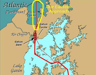
|
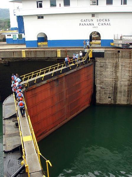
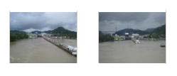
The first pictures that you will see this morning were taken from The Crow's Nest. Because of the glass windows, flash would not work, but in any case what was outside would have been far too distant for flash to have helped anyway. So we just had to wait for it to get light. Take a look at my first view of the Panama Canal here. As it started to get lighter, I found that if I held the camera braced on the back of the banquette next to the window, I could get an acceptable shot of the entry to the Gatun Locks. Unbeknownst to me, Fred had stopped at the stern on his own way up to The Crow's Nest and got his own first pictures of the day- one looking astern through the morning mist and the other looking down at two canal tugs.
The first thing I noticed as it just began to get light was that there were people down below us at the bow! In fact, the crewperson had been wrong, and the ship's personnel had in fact opened the bow for passengers. There were already, by 5AM, people lined up all across the bow, and it looked as if I had missed my chance to get a prime viewing spot. I was angry at being misinformed, although perhaps I should have confirmed what I had been told with multiple sources.
In any event, I told Greg that I was going to go down to the bow to see if I could find a spot to get a better view, but that I would be back if it was raining or I could not find a space. Greg did not want to be outside, so he was content to stay in The Crow's Nest with the other congenial folks he had already made friends with. I rushed down to Deck 4 and out to the bow. At first, I was at the back of a couple of rows of people, and really didn't have a good view. But just to the left of the sectioned-off bowsprit I found a couple who had taken chairs right up to the rail, and there was a space just in front of them where I would not be in their way if I crouched down a bit. So I wormed my way through the crowd to that spot, and was as nice as possible to everyone. As it turned out, there was an excellent place for me to crouch down and even a metal shelf on which I could sit in between picture-taking sessions. So although I would have been down here all night if necessary had I known the bow would be open, at least I got a very good spot in the end, so I suppose it worked out well.
|
There is, perhaps, no good reason to include this movie in the album save for the fact that it was the first movie I made today. It was taken from the bow, immediately after I had arrived down here from The Crow's Nest, and shows us approaching Gatun Locks from the eastern ship channel. |
|
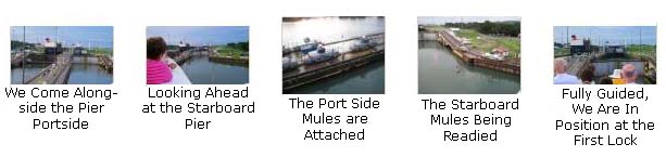
|
Prior to entering the first of the three locks here at Gatun, we must be tethered to the mules that will guide us into and through the three locks. To get attached to the portside mules, we have to come alongside the pier that juts out into the channel and holds the tracks on which the mules run. This movie shows us coming alongside that pier. |
Going Through the Gatun Locks
|
The First Lock at Gatun
Getting Into Position at the First Lock
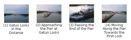
If you will click on the thumbnail images below, in sequence, left to right and top to bottom, I think you'll get a good idea of what was going on as the ship got positioned:
|
|
After the first Mule was attached to our ship, it began pulling us along slowly towards the gate of the first lock. This movie shows a bit of that process. |
Moving Into the First Lock
|
When we were in position outside the first lock gate, the water on the other side of the gate was at our level. So when the gates opened, as you can see them do in this movie, the ship could be pulled along into the first lock. |
|
Also, as we passed the now opened gate, I can show you how it fits flush into the canal wall.
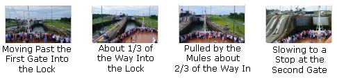
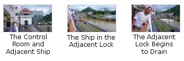
If you will click on the four thumbnails at right, you'll see four pictures that show the progress of our ship until it is entirely inside the lock.
|
As I said, although the ships engines are running, there are at idle, and the mules are doing almost all the work, pulling us into the lock. The rear mules slow us to a stop when we are fully inside. |
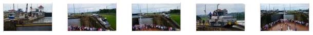
It was also interesting to see another ship beside us in the other lock. Because it was smaller, it was overtaking us. The next five thumbnails (below) are a sequence of pictures that show us as we come to the end of the lock and are stopped by the mules as they rise up their inclines to the next level. (If they didn't go up ahead of us, they'd be pulled out of position as the ship rose in the lock.) Have a look at this process by clicking on these thumbnails:
|
|
When both of the mules had climbed their inclines to the next level, we were fully inside the lock and, although I could not see behind the ship, I knew that the first gates were closing. This movie shows us coming to a stop inside the lock. |
The First Lock Fills and We Are Raised
|
|
When the levels of the two locks (the one we are in and the next one) are equal, the gates can simply open and allow the mules to pull us into it. Once we are out of our lock and its forward gate is closed, the water in it is allowed to drain into the ocean as the water seeks its own level, and the lock is ready for the next ship. It was originally thought that one set of locks would handle east-west traffic, like ours, and the other set would handle west-east traffic. However, it was found that ships could not pass each other at full speed in the Culebra Cut, so in practice all traffic goes one way for a while and then reverses, and both sets of locks go in the same direction until this reversal occurs.
The filling process becomes a draining process when a ship goes from Gatun Lake down to the Atlantic. A ship would move into the top lock which is at lake level. Then valves would open to allow 30 feet of water to drain into the next lock and into the Atlantic. In this way, the water in each lock is eventually changed out, and Gatun Lake water finds its way eventually to the ocean.
It's tough to show this process in pictures, but you can see a picture of our ship having been raised almost to the water level in the next lock here.
We Move Into the Second Lock at Gatun
|
|
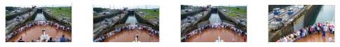 |
> In the sequence of pictures below, you'll be able to follow along as we move forward in the second lock, and come to a stop at the next set of gates. Click on the thumbnail images from left to right to follow along with us:

|
|
Fred made another good movie once our mules had reached the top of the inclines between the second and third locks. We are in place ready for our second lock to fill. |
The Second Lock is Filled
|
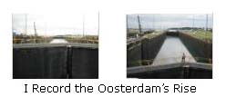
It may not be very interesting just to talk about, but standing at the bow and looking down into the lock and watching the water surge up from beneath us was actually very interesting, and maybe this movie will give you that impression. |
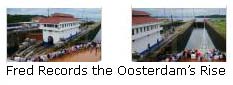
While I was making my movie looking down into the lock, Fred was recording the ship's rise by focusing on the bow and the mules alongside us. |
 |
 |
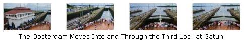
The Oosterdam Moves Into the Third Lock at Gatun
|
Now that we are at the level of the water in the third lock, the gates can be opened, and Fred recorded part of that process with this movie. |
Here at the gates between the second and third locks, I wanted to make a movie to show you that there are actually two sets of gates here, unlike the situation between the first and second locks. I am not sure why, except that one serves as a backup. |
Below is a series of pictures that will illustrate our progress into the second lock, where we stop just short of the final gates. You'll notice that both gates are in use here; perhaps they were in use before but we were too low to see them, but I think this is the first time they have both been closed.
|
|
From his perch a couple of decks above me, Fred made a good movie of our mule pulling us into the third lock. |
The Oosterdam is Raised to the Level of Gatun Lake
|
Again from his perch a couple of decks above me, Fred made a movie of the ship slowly rising as water from Gatun Lake is allowed to enter the third lock. He also made a picture of the view from his deck. |
While we were waiting for the ship to rise completely, Fred snapped a picture of the the ship in the other lock beside us; it had entered the first lock a while after us but, being smaller, has been moving through the locks more rapidly. It is ready to enter Gatun Lake. Meanwhile, I took a couple of pictures to our left and right. Looking down now, I could see both of the final gates.
|
Now that we are at lake level, the final gates began to open. Both sets were in use here. Once they were fully open, the way ahead was clear. |
The Oosterdam Leaves the Gatun Locks
|
After the last gates had opened, the mules guided us foward. In the other lane, the freighter Chaconia was also being pulled along, and it'll be a race to see who exits the canal first. |
The Chaconia did beat us to the end of the lock- or at least to the end of the mules' guidance. In this movie, you can see tehe Chaconia's lead mule come to the end of its track. Apparently, the mules have a quick release that allows the ship to continue under its own power into the lake. |
In these last two pictures of the Chaconia, you can see that it has first cleared the pier and, a few minutes later, is steaming out into Gatun Lake.
|
Meanwhile, the Oosterdam has been moving slowly along, and in this last movie of our passage through the Gatun Locks you can see the lines from the lead mule to our ship go limp as they are detached from the ship and we begin to move away under our own power. |
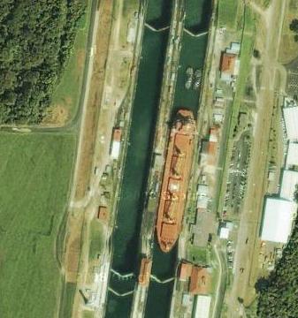
As we moved beyond the end of our pier, I left the bow to come inside and find Fred. A bit earlier, he, too, had left the front of the ship and moved back to the stern, where he had begun the morning over two hours ago. From there, he could look back at Gatun Locks and see two more Panamax ships being brought through (the one on the left is in the lane we were in and was, apparently, right behind us. If you will look at the closeup of the ship that was following us, you can see it has been raised to the level of the third lock and is about ready to move into it. This view also provides a good look at an entire lock's worth of mules and equipment. Have a look at that picture here.
|
Here is a really interesting part of that aerial view showing that two small boats are going through the locks at the same time as one much larger ship is:
Steaming Across Gatun Lake
|
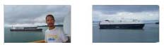
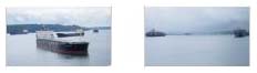
Before we went to breakfast, Fred and I met up back at our stateroom where we unloaded our camera cards and got prepared to take more pictures. From our balcony, Fred took some pictures of the ships that we passed; some were anchored and some were moving. The system for allocating times through the locks must be a complex one. If you will click on the thumbnail images below, you can see some of the pictures of the canal traffic that we took from our balcony:
|
|
|
Ships in Gatun Lake |
We went on to breakfast where we hooked up with the rest of the guys, and we had breakfast by the Lido Pool. Fred took one picture of the group and I took another; you can see his here and mine here. Right after breakfast, we went over to the other end of the Lido Pool where they were having a sale on Panama Canal themed stuff, and I bought a couple of t‑shirts.
Then we just walked around on the decks for a while, passing the time until we came to the Culebra Cut. Fred got a candid of Greg, Paul and I and I took a picture of Greg and Fred. We passed more ships in Gatun Lake and, south of the ship, a road/rail bridge over a side channel of the lake.
|
As we made our way through Gatun Lake towards the Culebra Cut, the lake narrowed into just a finger, and it was hard to tell when, exactly, we passed into the Cut itself. I suppose the only clue was when we were passed by the last large ship, since traffic for large ships is one way only through the cut itself. The other clue would have been spotting the Centennial Bridge, which is over the Cut near the Pedro Miguel Locks, but we haven't seen that yet, either. So I suppose these are the last few pictures taken while actually on Gatun Lake. Click on the thumbnails at right to have a look at them.
|
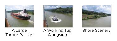
After breakfast we'd gone back to our room, and from our balcony I made this movie of a very large tanker passing us. This meant that we were not yet in the Culebra Cut. |
A little while after we were passed by the tanker, a small tugboat came up alongside from the rear. After the tanker, no more large ships were seen, so we thought it was about time to go up on deck to see the Culebra Cut and Centennial Bridge. |
Navigating Through the Culebra (Gailliard) Cut
|
|
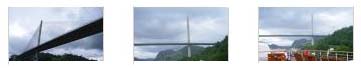
At about twelve-fifteen, we could finally look ahead through the Cut and see the new Centennial Bridge. The Centennial Bridge is one of only two major bridges crossing the Panama Canal. (There are two small service bridges built in to the lock structures at Miraflores and Gatún Locks, and you saw a picture of the one at Gatun earlier. But these bridges are only usable when the lock gates are closed, and have limited capacity.) The Centennial Bridge was built to supplement the overcrowded Bridge of the Americas.
The Centennial Bridge is located 9 miles north of the Bridge of the Americas, and crosses the Gaillard Cut close to the Pedro Miguel locks. New freeway sections, connecting Arraijan in the west to Cerro Patacon in the east via the bridge, significantly alleviate congestion on the Bridge of the Americas. The Bridge of the Americas, which opened in 1962, was the only major road crossing of the Panama Canal. The traffic over that bridge was originally around 9,500 vehicles per day; however, this expanded over time, and by 2004 the bridge was carrying 35,000 vehicles per day.
Since the bridge represented a major bottleneck in the Pan-American Highway, Panama's Ministry of Public Works requested tenders for a second canal crossing in October 2000. The contract to build a replacement bridge was awarded in March 2002. An ambitious schedule of just 29 months was set for construction, in order that the bridge could open on the 90th anniversary of the first ship transit of the Panama Canal by the cargo ship Ancon, on 15 August 1914. The bridge was named for Panama's centennial, which occurred on November 3, 2003. (I might mention here that in my movies I have erroneously referred to the bridge as the "Millennium Bridge." I don't know where I picked that up.)
|
|
I made this movie from a ways west of the bridge (remember that when you traverse the canal, you are actually going eastward) and it shows the Culebra Cut and the upcoming bridge. |
It was raining, so I made this movie from underneath an overhang at the back of the bow area. It is a long movie, but it takes us all the way under the bridge, and ends with the bridge directly overhead. |
Now it began to rain rather heavily, so we went inside and up to the Lido Deck to sit by the windows. When we got there, we were passing this large tanker that was apparently being held in place or pushed to the side of the canal by the two tugs. We continued to sit by the windows until we approached the Pedro Miguel Locks.
Descending Through the Pedro Miguel Locks
|
We did not take pictures here to the level of detail that we took at Gatun. For one thing, the lock works just exactly like the ones at Gatun, except in reverse. (The lock is at lake level when you are pulled into it, and when the gates close, the water seeks the level of Miraflores Lake thirty feet lower; gravity does the work. The lower gate opens and the ship can be pulled through into the lake.) So the same procedures used at Gatun are used here- mules, gates and all. The other reason we didn't take as many pictures was that the weather had turned worse, and it was raining intermittently. This made being at the bow (or anywhere outside on the ship) a dicey proposition. We did get outside for some of the pictures, but others were taken through the windows in the Crow's Nest or from the sheltered areas outside on Deck 10. The rain let up enough that we did get some good pictures.
All I really need to do here, then, is show you some of the pictures we took that are representative of our entry into the lock and our exit from it into Miraflores Lake. So, if you will first click on the thumbnail images below, you can see the best of the pictures we took as we entered the lock at Pedro Miguel:
|
Once inside the lock, the procedures were the same.
|
The gate behind us has closed, and the valves have been opened to allow the water to drain from our lock; you can see it coming out into the lake ahead of us. I am in the Crow's Nest and there are some background voices. |
The water has drained and we are now at the level of Miraflores Lake. So the gates in front of us open slowly to allow us to leave the lock. |
|
The gates have opened and now our mules can help us move out of the lock and into Miraflores Lake. In this movie, you'll also see the ship in the lock next to us. The rain has let up, and how we are on the Promenade Deck. |
|
|
I'd actually intended just to take a short movie of the activities in the lock next to us, but I happened to catch it just as the valves were being opened to allow the water to drain into the lake, lowering the Panamax vessel. |
 |
 |
In my two pictures (the bottom row of thumbnails at the left) you can see both locks and the pier and a shot of the gates on the adjacent lock to us opening.
Click on the thumbnails to view these pictures.
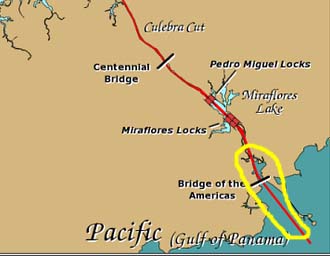
Descending Through the Miraflores Locks
|
Another difference was in the road that crosses the canal here at the locks. If you remember at Gatun, the little roadway went through a tunnel underneath one of the first inclines, and across two bridges that are put in place when there is a gap between ships. Here at Miraflores, the road crosses two swivel bridge spans. These swing into position to form a continuous roadway again when there is a gap between ships. This road must only be for a small amount of local traffic- probably most of it associated with the operation of the locks- because the Bridge of the Americas is not very far ahead (perhaps a mile or two).
Coming through the Miraflores Locks was the first time that we had descended through more than one lock, and it was a little disconcerting to see the full lock that we were moving into and just beyond the closed gate a dropoff of about thirty feet to the next one. I wondered what would happen if the gate failed while we were in the upper lock!
Again, having been through a descending lock already, we did not take a great many more repetitive pictures. This time, our pictures were more about the areas surrounding the locks (we were quite close to Panama City, and so there were actually spectators on the administration building balcony watching the ships). If you'll click on the thumbnail images below, you can see some of these pictures:
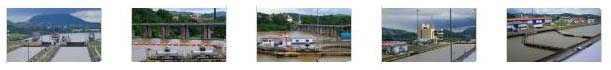
|
|
I made a mistake in this movie of the Oosterdam coming into the first Miraflores lock- I said we were leaving the locks. The ship beside us was incredible. |
This second movie at Miraflores shows us once again getting ahead of the ship Continental Highway and leaving the second of the Miraflores locks and the last lock on the canal. |
Our Pacific Exit From the Panama Canal
|
|
 |
 |
| Actually, if you want a real chuckle, you can see a picture that Fred took of me while I was taking the two pictures above if you click here. |
Fred also took a pretty good movie that will transition us from the Bridge of the Americas to Panama City.
|
Just after we'd passed under the Bridge of the Americas and could see Panama City, Fred did an excellent movie of the bridge and the city, using his zoom and doing some narration. A must see. |
As the channel widened, we began to pass an area called Andandor on our port (Panama City) side. This area appeared to be either a residential or resort area; there were what looked like hotels and apartments and a good many small docks and marinas. One of the most interesting sites we passed looked at first like a building being demolished; it looked like a pile of jumbled girders and masonry. When we got a better look, though, we could see scaffolding, indicating that the building was actually under construction which, we found out later, it was. It will be the new Panama Biodiversity Museum, and it's being designed by Frank Gehry. We'll learn more about it tomorrow.
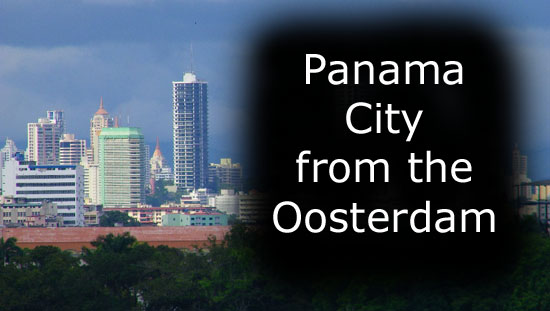
We got our first look at Panama City way back at the Miraflores Locks, but we hadn't really gotten a good view until now. As we came down the widening channel towards the ocean, we got some views of the new skyscrapers that make up the central core of Panama City. Actually, these views were probably the most surprising of the entire cruise. My mental image of Panama City had always been an older town, not nearly as big and not nearly as modern. Actually, if you look at one of the pictures Fred took with his telephoto and just mentally eliminate the backdrop of skyscrapers, my mental image of Panama City would have looked like this. If I'd ever thought about it, I would have assumed that there would have been some new construction, if only because of the money and people that the canal and its associated shipping bring in. But I was entirely unprepared for what looked like a brand new New York City or Dubai. As if the downtown core weren't spectacular enough, we could look further down the coast to the east and see an entirely new residential area composed of another package of skyscrapers. At least one of them seemed to be 70 storeys tall! We would see a lot more of the city tomorrow, but the views we got, and especially the views Fred got with his amazing telephoto lens, were spectacular.
|
To view the slideshow, just click on the image at left and I will open the slideshow in a new window. In the slideshow, you can use the little arrows in the lower corners of each image to move from one to the next, and the index numbers in the upper left of each image will tell you where you are in the series. When you are finished looking at the pictures, just close the popup window.
As we continued along to the Pacific, we were passing a long, artificial causeway that connects the mainland to a group of islands just offshore. This causeway was barely wide enough for the road that it carried and a bit of parkland on either side. There were some piers and docks along it. At the end of it were a group of three islands which are, I believe, called (collectively) Isla Naos. We'll see more of them tomorrow since that is where the tenders from the ship docked.
|
As we passed the islands that make up Isla Naos, Fred took another good movie of the passing islands, the cityscape, and the channel leading back underneath the Bridge of the Americas. |
|
|
As I said above, a small boat came out to the Oosterdam while we were underway, tied up (I think) alongside at one of the gangway doors, and (and again I am assuming) took off the canal/harbor pilot and then pulled away. |
We continued on past these islands and headed northwest, I think. I don't know how far we went, but I assume we went just far enough so as to get out of the active shipping lanes. We ended up in an area where there were lots of other boats at anchor and we, too, anchored for the night. We'd be going back to Isla Naos to disembark in the morning to go into Panama City.. Just after it got dark, a large tanker ship came alongside and we took on more fuel.
|
Although you can't see anyone doing much, since I am on our balcony, you might want to watch this short movie of the refueling process that went on this evening. |
Evening Activities

|
David Brouwer is the lead male singer for the Oosterdam Singers and Dancers, and this evening he is the featured performer for the show in the Vista Lounge. He did a selection of songs in a style that was supposed to imitate Frank Sinatra, and he did so in all but the voice. I'd sum him up as a singer just below the American Idol final twelve category, certainly serviceable for the Oosterdam but not good enough to make me want to download his songs (if they were available).
He was joined in a one of the numbers by the ship's permanent fixture in the Crow's Nest- guitar player/singer Taylor Brown. He was also joined by Randall Powell, the rotund piano player from the Piano Bar.
|
This movie shows David Brouwer's style of singing as he performs solo with the band as backup. |
Singer Brouwer and guitarist Brown perform together. |
|
Brouwer is joined by the other three lead singers from the troupe and also by pianist and singer Powell, and they all perform together. |
We had dinner with the guys in the Vista Dining Room, and then Fred and I went to the screening room to watch the movie. Tonight, it was "Nothing Like the Holidays," which took your typical "family members all return to their old house for Christmas and there are laughs and tender moments galore as everyone finally comes to understand everyone else" kind of holiday movie (which is bad enough) and turned it into the Rodriguez family in Chicago (which made it worse, unless you're Hispanic, of course). We left after half an hour.
You can use the links below to continue to the album page for different day.
|
November 9, 2009: Panama City, Panama |
|
November 7, 2009: A Sea Day |
|
Return to the Index for Our Panama Canal Cruise |