|
October 1, 2011: Walking Around North Boston |
|
September 29, 2011: The New Hampshire State House |
|
Return to the Index for our New England Trip |
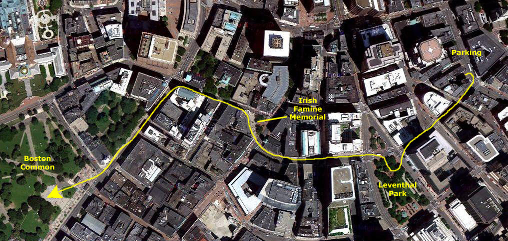
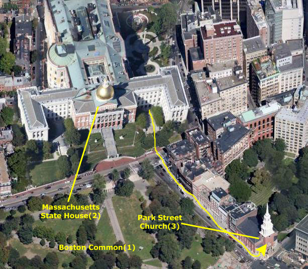
Well, today is Friday, the next to last day of our trip, and the last day we will be visiting a state Capitol. We plan to spend all day today in Boston. We will be following the "Freedom Trail," which will take us through downtown Boston from one historic site to the next. There are 16 sites in all, but we will save the last two until tomorrow, as they are across the Charles River from most of the trail downtown. Our first task will be to drive into town and find a place to leave the car for the day, and then walk over to Boston Common, where the Freedom Trail begins. The index for today's page will include a link to each stop on the Freedom Trail.
Getting into Boston was fairly easy, although the new underground tunnels can be confusing. To get into town, we just took I-93 south to cross the bridge over the Charles River. Then, after some confusing twists and turns as we came up aboveground, we ended up parking in a rather expensive lot about ten blocks from Boston Common. Leaving the parking lot, I followed my nose as we wandered generally in the direction of The Common. We passed some of the sights we would see on the Freedom Trail, and we took some pictures of them, but I'll put those pictures along with the others we took as we actually followed the Trail.
|
|
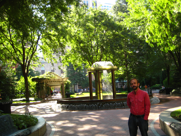
More than a hundred different species of plants, flowers, bushes and trees are within the park. It features custom wrought-iron fencing and specially designed drainage gates. Seating styles fit every posterior and mood – stately teak benches, curving steel settees, movable cast-iron café chairs with tables, hundred of linear feet of inviting polished granite wall and half an acre of lawn, all meticulously maintained. It is visited daily by thousands of all kinds of people.
The other stop we made on the way to The Common was at Irish Famine Memorial. Originally proposed in 1991, the project wasn't acted on until 1996, when Thomas Flatley, a local real estate developer and an immigrant himself, met with then Mayor Menino to revive the project. Flatley and business leaders, along with scholars, writers, clergy, and presidents of Irish-American organizations undertook the design and fundraising for the memorial. The memorial is located at the corner of Washington and School Streets, just a few blocks from where the Irish refugees first crowded into tenements along Boston's waterfront. The memorial, and its signature sculpture were dedicated on Sunday, June 28, 1998.
We continued generally west, and actually passed some of the sites we'd encounter officially on the Freedom Trail, and reached Boston Common a few minutes later. There, we found that the official Visitor Center was undergoing renovation, so I had to go find it at its temporary location, get some brochures and rejoin the guys who were waiting in The Common. Then our experience of the Freedom Trail began.
Boston is a very accessible city, but it may be that its reputation as a walking city relies on the creation of one of America's first historic walking tours, The Freedom Trail. The Freedom Trail Foundation continues to work to preserve this perfect introduction to Colonial Revolutionary Boston. The Trail takes the visitor to 16 historical sites in the course of two or three hours and covers two and a half centuries of America's most significant past. A red brick or painted line connects the sites on the Trail and serves as a guide. Since the past and the present live alongside the Trail, its visitors have the opportunity to see the City as it truly is. Many visitors prefer to linger and study the many exhibits, thus a full day or more can be devoted to browsing along the Trail.
The Boston Common (Freedom Trail Stop #1)
|
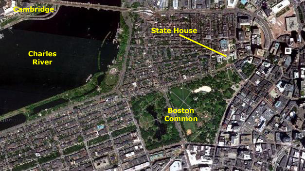
Today, Boston Common is the anchor for the "Emerald Necklace," a system of connected parks that winds through many of Boston's neighborhoods. In the aerial view, for example, you can see the string of narrow parkland that extends from The Common through the tony neighborhoods to the southwest. These parks continue, with some short interruptions, all the way to the near suburbs. You can also see the connection to the Charles River Esplanade and to the parkland across the river in Cambridge. Those parks continue towards MIT and Harvard. The city has done an excellent job of reserving greenspace for its residents.
The "Common" has been used for many different purposes throughout its long history. Until 1830, cattle grazed the Common, and until 1817, public hangings took place here. British troops camped on Boston Common prior to the Revolution and left from here to face colonial resistance at Lexington and Concord in April, 1775. Celebrities, including Martin Luther King Jr., Pope John Paul II, and Gloria Steinem (advocate of the feminist revolution), have given speeches at the Common, and that sense it is America's version of London's Hyde Park Speaker's Corner.
|
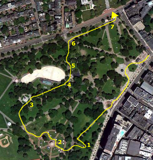
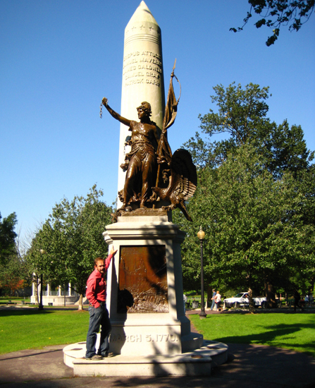
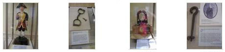
We met up at the Robert Adolf Kraus Boston Massacre/Crispus Attucks Monument that is located on the east side of The Common just off Tremont Street (1). This monument commemorates the events of March 5, 1770, when British soldiers, later to be successfully defended by John Adams, shot down five Bostonians. (Actually, we will learn a good deal more about this event later on the Freedom Walk when we visit the site of the actual "massacre." Crispus Attucks is the best known of these five, although surprisingly little information about him can be verified. His grave is located in the nearby Granary Burying Ground that we will visit a bit later.
|
|
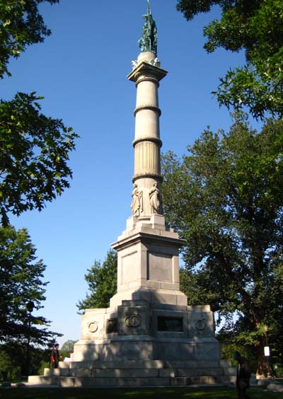
From the Bandstand, we walked north across The Common heading towards Beacon Street, and after a short distance came to The Soldiers and Sailors Monument.
|
The 126-foot monument is located on a rise called Flag Staff Hill. It is neoclassical in design, taking the form of a victory column carved of Hallowell white granite. The platform is 38 feet square and features four bas-relief bronze tablets. The first tablet is titled The Departure for the War, and depicts a regiment marching by the Massachusetts State House. The second bas-relief tablet depicts the medical care on the battlefield and is titled The Sanitary Commission. The third tablet depicts Union sailors in an engagement between a Federal man-of-war and a Confederate ironclad likely the CSS Virginia. The fourth tablet, entitled The Return from the War shows a regiment of veterans marching by the State House to present their battle flags to Governor John Albion Andrew.
Above the bas-relief tablets at the base of the column are four 8-foot carved granite figures representing the northern, southern, eastern and western sections of the reunited nation. Bronze statues that formerly stood on the monument's corners representing peace, history, the army and the navy have been placed in storage to prevent further deterioration and vandalism. Surmounting the doric column is a bronze allegorical female figure titled AMERICA. She is crowned by thirteen stars, and in her left hand holds the United States flag, in her right hand she holds a laurel wreath and sword.
The base bears the following inscription: "To the Men of Boston who died for their country on land and sea in the war which kept the Union whole, destroyed slavery and maintained the Constitution, the gratefuly city has built this monument that their example may speak to coming generations."
From the Civil War monument, we angled off northeast through The Common, following the directions in the Freedom Trail brochure. We came along the east side of Frog Pond, and I had Fred stop so I could take his picture with the pond's namesakes (4). As we came around to the north of the water feature, I stopped to have a look back at Frog Pond (5).
|
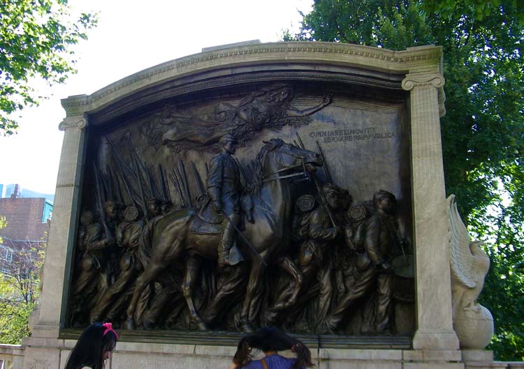
This memorial, designed by Augustus Saint-Gaudens (you can read the inscription about Saint-Gaudens that is situated near the memorial here) and Stanford White, was built in Shaw's memory in 1897. Robert Gould Shaw (1837 – 1863) was an American officer in the Union Army during the American Civil War. As colonel, he commanded the all-black 54th Regiment, which entered the war in 1863. He was killed in the Second Battle of Fort Wagner, near Charleston, South Carolina. He is the principal subject of the 1989 film Glory, where he is portrayed by Matthew Broderick.
Born in Boston to a prominent abolitionist family, joined the Union Army in 1861. He was asked by his father in late 1862 to take command of a new All-Black Regiment. After careful thought he accepted the position. Shaw's letters clearly state that he was dubious about a free black unit succeeding, but the dedication of his men deeply impressed him, and he grew to respect them as fine soldiers.
Shaw was promoted to major on March 31, 1863, and to colonel on April 17. The 54th Regiment was sent to Charleston, South Carolina, to take part in the operations against the Confederates stationed there. On July 18, 1863, along with two brigades of white troops, the 54th assaulted Confederate Battery Wagner. As the unit hesitated in the face of fierce Confederate fire, Shaw led his men into battle by shouting, "Forward, Fifty-Fourth Forward!" He mounted a parapet and urged his men forward, but was shot through the heart and he died almost instantly.
|
You can see the front of the memorial at left; it is at street level just in front of the Massachusetts State House.
On the lower level of The Common, you can see the reverse side of the monument. But you'll have a hard time reading the inscription that was written by Charles W. Eliot, then president of Harvard University, so I blew up the image and transcribed it for you. It reads exactly as follows:
|
To The 54th Regiment of Massachusetts Infantry The white officers taking life and honor in their hands — cast in their lot with men of a despised race unproved in war and risked death as inciters of servile insurrection if taken prisoners — besides encountering all the common perils of camp march and battle the Black rank and file volunteered when disaster clouded the Union cause — served without pay for eighteen months till given that of white troops — faced threatened enslavement if captured — were brave in action — patient under heavy and dangerous labors — and cheerful amid hardships and privations. Together they gave to the nation and the world undying proof that Americans of African descent possess the pride courage and devotion of the patriot soldier. One hundred and eighty thousand such Americans enlisted under the Union Flag 1863-1865. |
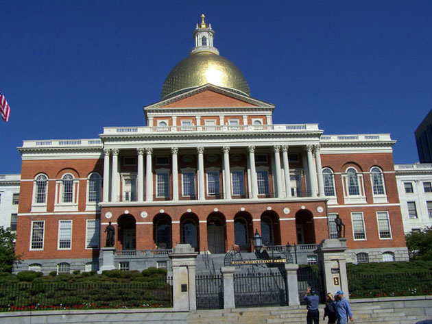
Now it was up the steps and across Beacon Street to the Massachusetts State House.
The Massachusetts State House (Freedom Trail Stop #2)
|
|
A large extension, built of yellow brick (yellow area), was added to the back of the Bulfinch State House between 1889 and 1895. It was designed by Charles Brigham, who made extensive use of marble, wrought iron, and carved wood paneling in the elegant interior. The most recent additions, which were completed in 1917, are the two white marble wings to the east and west of the State House (white areas).
When we got inside the State House gates, the signs directed us to a public entrance known as the General Hooker Entrance, so named because of General Joseph Hooker, the career Army officer who fought on the side of the Union during the war- usually with distinction. He is best remembered, however, for his stunning defeat at the hands of General Robert E. Lee at the Battle of Chancellorsville. We went inside this entrance and took the elevator to the second floor to begin our tour.
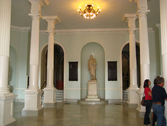
Doric Hall
|
As a main reception room, Doric Hall has served as the setting for uncounted formal and informal gatherings including banquets, press conferences, swearing-in ceremonies, and other special events. It was here, at the beginning of the Civil War, that arms, ammunition, and other equipment were distributed to company after company of volunteers to the Sixth Massachusetts.
|
From the Doric Hall, we went through one of the two archways into Nurses Hall.
Nurses Hall
|
|
|
Nurses Hall is built largely of Pavonazzo marble, named because of the statue of an Army war nurse aiding a fallen soldier located on our right as we entered the hall. Sculpted in 1914 by Bela Pratt, it was the first statue erected in honor of the women of the North after the Civil War. Although the main staircase in the State House begins in the Hall of Flags, there are two staircases leading from Nurses Hall to the office areas on the third floor.
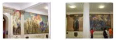
Nurses Hall also features several murals by Robert Reid depicting events crucial to the start of the American Revolution. Paul Revere's ride of April 19, 1775 is on the left, the Boston Tea Party is on the right. The central panel portrays the true beginning of the colonists' break with England. Fiery orator James Otis is pictured arguing against the Writs of Assistance, which allowed British soldiers to enter private homes and shops in search of smuggled goods. Refusing payment from the Boston merchants who retained him, Otis presented his case in February 1761. Although he did not win the case, Otis was described by John Adams as "a flame of fire... then and there the child Independence was born".
From Nurses Hall with its murals and coffered ceiling, we passed through another set of archways into the Hall of Flags.
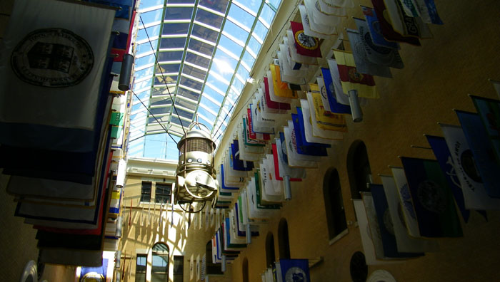
The Hall of Flags
|
|
|
|
Edward Simmons depicted the Battle of Concord in another mural in the Hall, and other include Henry Walker's portrayal of the Mayflower Pilgrims as they first sighted land and his interpretation of John Eliot preaching to the Native Americans.
The stained‑glass skylight above contains the seals of the original thirteen colonies of the United States with the Seal of the State of Massachusetts in the center.
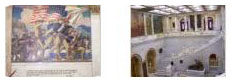
Before going up to the third floor, we continued back through the building on this floor to The Great Hall.
The Great Hall
|
|
|
|
After answering some questions, our tour guide took us back to the Hall of Flags where we could ascend the main staircase to the third floor and the legislative chambers.
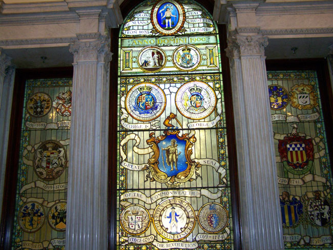
The Main Staircase and Stained Glass Window
|
|
|
|
It was a little inspirational, standing at the bottom of the stairs and looking up at the stained glass window.
|
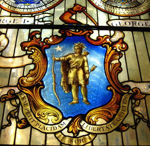
When Massachusetts became part of the New England Royal Dominion in 1684 a new seal, shown below the first, was adopted. The family seals of the provincial governors appear on the two side panels and the Revolutionary seal is located at the bottom of the window. This seal portrays a colonist clutching the Magna Carta in one hand and a sword in the other. Our current state motto, "Ense petit placidam sub libertate quietem", was adopted at that time. It means "By the sword we seek peace, but peace only under liberty."
|
The English translation of that Latin phrase is "By the sword we seek peace, but peace only under liberty."
From the landing, I could look back down the main staircase to the design in the marble floor at the base of the stairs, and you can see that view here.
Our next stop would be the Massachusetts House of Representatives chamber.
The House of Representatives
|
The Chamber has a beautiful coffered ceiling and dome that you can see much better in one of Fred's pictures here.
|
It is in this room that the larger of the two legislative bodies conducts its business. The Speaker of the House is elected by the representatives and presides from the elevated chair behind the podium. Representatives can vote electronically by pushing a green "yea" or a red "nay" button on their desks. The results of the vote appear next to each representative's name on the boards in the front of the room.
|
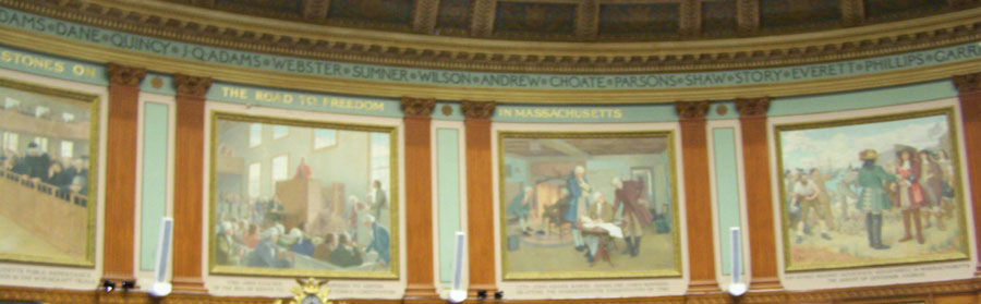
The room is paneled in Honduras mahogany. Behind the Speaker's podium are the Albert Herter murals, "Milestones on the Road to Freedom." Some of these are shown above. The names on the ceiling cornice commemorate men who made important contributions to the commonwealth and the nation prior to 1895. You can see one of these panels in close-up here.
|
|
Above the House Chamber floor are the galleries for the public, guests of the Speaker, and the press.
|
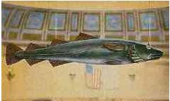
Probably the oddest feature of the chamber is the famous Sacred Cod, which hangs over the entrance to the chamber and which symbolizes the importance of the fishing industry in the early Massachusetts economy. It was given to the House in 1784 by a Boston merchant, Jonathan Rowe. It is considered to be a good luck charm and must always hang above the House Chamber for the session to be held.
Of course, something so seemingly trivial but with such outsize importance is always a tempting target for pranksters, and when there is a large university, like Harvard, in close proximity, the danger rises exponentially. All manner of prized items are regularly spirited away at campuses throughout the world: statues, bells, trophies, road signs, etc. But precisely because theft is such an obvious form of pranksterism, it has an extra hurdle to overcome in order to achieve originality. Such originality can be achieved in two ways — either through the ingenuity of the method of theft, or, as in the case of the Sacred Cod of Massachusetts, through the novelty of the object stolen.
Some might see the decision of the Massachusetts legislature to deliberate beneath a wooden cod as just a charming eccentricity, but the 1933 staff of the Harvard Lampoon (Harvard’s monthly humor magazine) saw it as a gauntlet thrown down. The full story of what happened next is an entertaining read, so I'll let you do so for yourself if you wish. To read the full story as reported in newspaper accounts of the time and pieced together from conversations with the participants and historical sources at Harvard University, just click the link below:
Third Floor Atrium, Artwork and Hallways
|
|
|
Next, we walked down the hall to the Executive Offices.
The Executive Offices
|
The waiting room itself is furnished in a sedate, tasteful style, and portraits of recent Governors hang in this room.
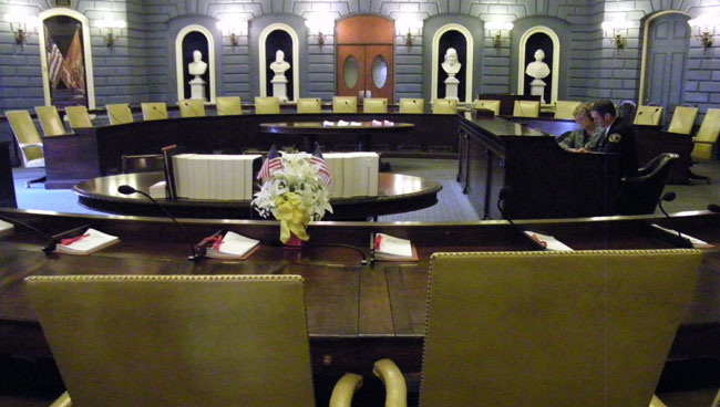
The Senate Chamber
|
|
|
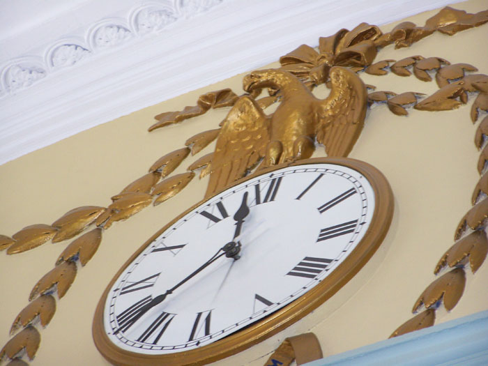
There are forty Senators, thirty-nine of whom sit around the circle of desks. The fortieth, the Senate President, who is elected by his peers, sits at the rostrum under a golden eagle. Voting in the Senate is still done by voice.
|
Near the visitors area is a bust of Marquis de Lafayette, a great friend of the American people, who visited the chamber on his way to lay the cornerstone for the Bunker Hill Monument in 1825. (Actually, the bust of Washington was at one time thought to be of Samuel Adams, but the identity crisis was cleared up with the help of Lafayette during that visit when he commented, "That's the Washington I knew!") Much more recognizable is the bust of Benjamin Franklin.
Several presidents, including Jackson, Monroe, and Van Buren, were welcomed here. It was in this chamber, too, that Angelina Grimke made political history when, in 1838, she gave a speech advocating the abolition of slavery. She was the first woman to address a United States legislative body. Finishing in the Senate Chamber, we headed off to our last stop on this floor- the Senate Reception Room.
The Senate Reception Room
|
|
|
Most of the elegant Bulfinch features may still be seen here. The four Ionic columns supporting the barrel‑vaulted ceiling are the only original columns standing in the Bulfinch Front today. Each was carved from a single pine tree.
The paintings lining the walls of the Reception Room portray some of the former Senate presidents, including Calvin Coolidge and Horace Mann. This room is now used for conferences and occasional receptions.
|
The Senate Reception Room completed our tour of the third floor, so our guide took us back down to Doric Hall to answer questions and sum up.
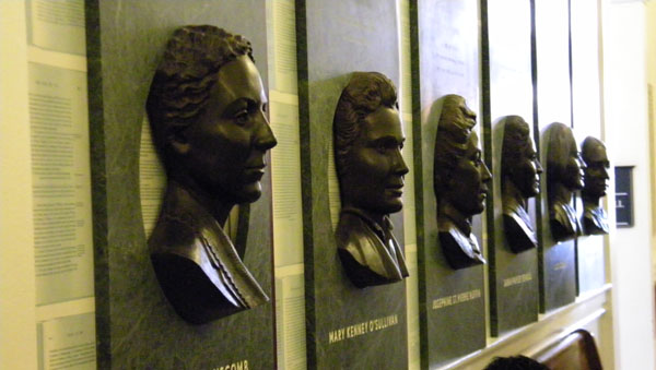
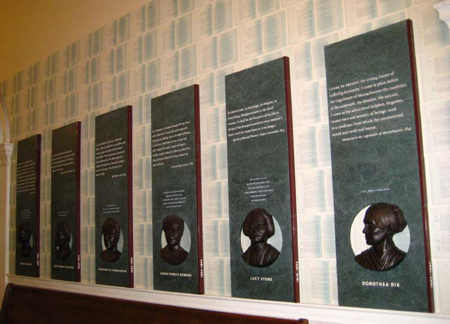
"Hear Us"
|
The artists' choice of bronze and marble links the new work to the statues and plaques that fill the halls of the State House. The use of type continues the tradition of commemorative plaques found throughout the building— but with an important difference: the words you read on these panels are the women's own. They come from pamphlets, speeches, articles, newspaper writings, autobiographies, and oral histories.
|
If you would to learn more about any of the women, just click on her plaque in the picture at right, and if you would like to see the six government documents, just click anywhere on the wallpaper above the six plaques in that same picture.
The "Hear Us" installation completed our tour of the Massachusetts State House, so next it was back outside to pick up the Freedom Trail again.
|
The actual path was perhaps two bricks wide, and very easy to follow. You can see the beginning of the trail of bricks in the picture at left. (Where bricks were not appropriate or possible, the sidewalk or whatever you were walking on was painted red.)
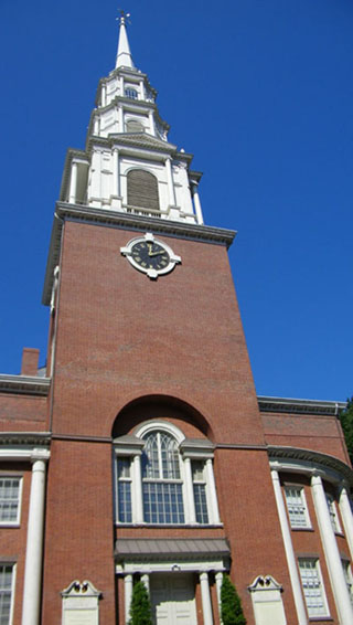
I could see that the path led across the street and southeast in the direction of the Park Street Church that we could see just a block away. So since the other guys had already crossed Beacon Street and were walking down the north sidewalk along Park Street, I went over to join them. But from the Park Street Church onward through the rest of the day, all we had to do was follow the marked path to go from one site to the next. I thought it to be a really neat idea; it certainly keeps one from having to consult a downtown map so often.
|
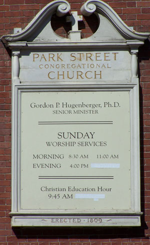
The Park Street Church (Freedom Trail Stop #3)
|
|
By mid-March, the committee located a site at the corner of Park and Tremont Streets, atop the site of Boston’s town grain storage building, or granary, and Park Street Church was founded. Park Street Church is located at Brimstone Corner which may have received its name because preachers spoke of fire and brimstone in Hell to their congregation or because sulfur was stored in the basement of the church.
|
|
Designed by Peter Banner, the 217‑foot steeple of this church was once the first landmark travelers saw when approaching Boston. (Now, of course, it is dwarfed by skyscrapers.) Celebrating its Bicentennial in 2009, Park Street Church’s lofty architecture reflects an even loftier mission of human rights and social justice. Prison reform began in this church, women’s suffrage was strongly supported here, and some of the first and most impassioned protests against slavery were delivered inside these hallowed walls.
Park Street Church became known for supporting Abolitionist causes, hosting an anti-slavery lecture series as early as 1823. As part of the lecture series, a young William Lloyd Garrison delivered his first major public Abolitionist speech, on July 4, 1829. Two years later, "My Country 'Tis of Thee" was sung for the first time by the church children's choir. Still active in Boston as a Congregationalist church, it continues to hold weekly religious services. The Park Street Church is one of the most historically significant buildings in the story of the Abolition's history of the nation.
|
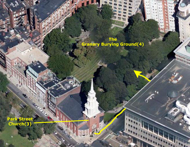
So all we had to do was to follow the row of red bricks northeast along Tremont Street for about a hundred feet until we came to the gates of the cemetery.
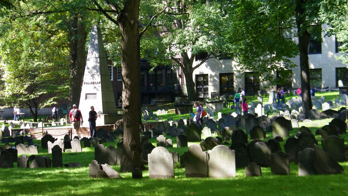
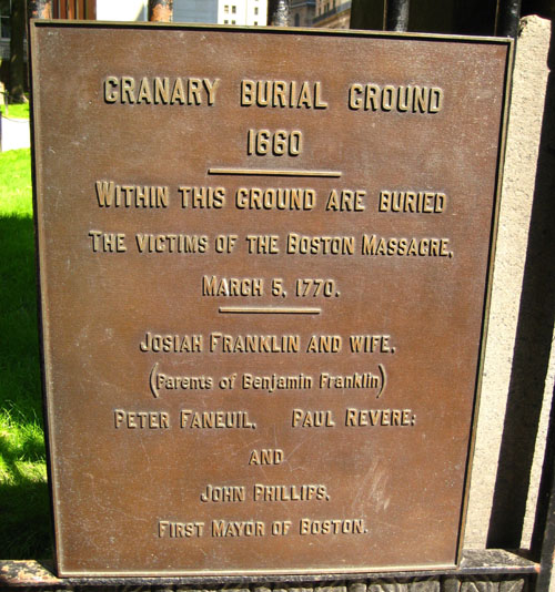
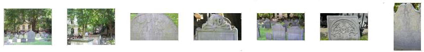
The Granary Burying Ground (Freedom Trail Stop #4)
|
The Infant's Tomb, where an estimated 500 children have been interred, is located near the central obelisk that marks the graves of Benjamin Franklin's parents. Alongside the far wall to the southwest is the elaborately embellished marker of John Hancock's tomb. Toward the rear Paul Revere is buried; a larger marker placed in the 19th Century stands by a small slate marker that dates from Revere's burial. Bookend monuments in the two front corners of the burial ground represent patriots James Otis and Samuel Adams. Sam Adams had the Boston Massacre victims interred in his family tomb, and so beside the marker of that tomb is one for the victims: Crispus Attucks, Samuel Gray, Samuel Maverick, James Caldwell, and Patrick Carr. On the right hand wall is a plaque marking the tomb of Robert Treat Paine.
|
|
We entered the cemetery through the gate at Tremont Avenue; it is the only public entrance to the two-acre plot. On the top lintel of the gate there is an interesting carving; I never did find out its significance. On the wrought-iron fence just to the left of the entrance gate there is a marker about Paul Revere, indicating that he is buried here. From the back of the burial ground, Fred took a picture looking towards Tremont Street, and below are two thumbnails for other pictures of the grounds Steve and I took; click on those thumbnails to view:
|
|
There were two different kinds of pictures we took. Obviously, we took pictures of some of the gravestones- some of well-known people, some not, but all interesting. We also took, between us, pictures of all the interpretive signs throughout the cemetery; these provided a wealth of interesting information not only about certain aspects of history as they relate to the Granary Burying Ground, but also about many of the graves nearby. I'd like you to see these pictures and be able to read these markers.
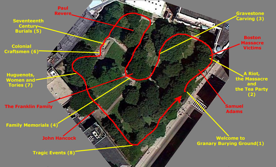
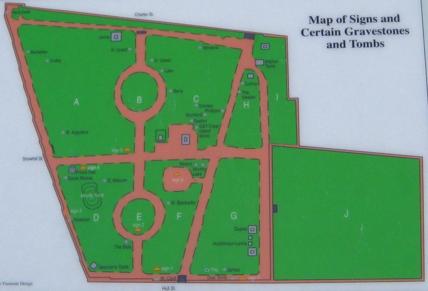
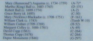
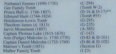
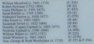
Below is an aerial view of Granary Burying Ground (I've greyed out most of the surrounding buildings to focus on the cemetery itself), and I have marked the general path we took while walking through the area. Along the sides you will find the titles of these interpretive signs (in yellow) as well as the names of some of the notable persons buried here (in red). Each one of those titles and names is a clickable link.
If you want to read one of the interpretive signs, just click on its name and a window will open up with the picture we took of it. Since not all our pictures were clear enough for you to actually read the signs, I have blown them up and transcribed when is on them for you, and added that to the picture. Where possible, I'll also enlarge the various pictures and diagrams that appear on the interpretive signs. When you are finished reading a sign, just close its window.
As for the personages, clicking on a name will bring up either a single picture of the grave or a window with multiple pictures. Again, when you are done looking at the grave picture(s), just close the window.
I hope you will want to look at some of the pictures we took, and I think that you will enjoy reading some of the interpretive signs. I encourage you to read at least "Gravestone Carving" (sign #3), as the information it contains will make some of the candid shots we took in the Burying Ground more understandable. So spend as much time as you like here; it will be time well-spent. Here's the aerial view:
|
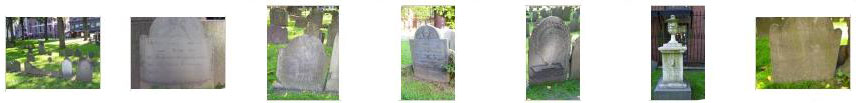
Now for the candid shots that we took here in Granary Burying Ground. Fred was very interested in the carvings on the gravestones, and, of course, if you've read sign #3, you know about some of the types. In many of his pictures below, you can see some of these types of carvings. Just click on the thumbnails to view his pictures:
|
|
|
This fellow was talking about the British and lobsters, and if you will watch my movie with the player at left, you can listen in.
We did some further walking around the cemetery, and took some other interesting pictures. Below are thumbnails for some of the best of them; just click on the thumbnails to view:
|
|
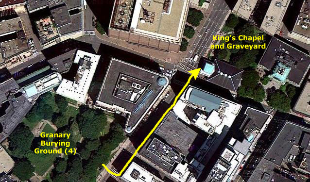
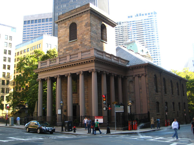
King's Chapel and Graveyard (Freedom Trail Stop #5)
|
The first King's Chapel was a tiny church used by the King's men who occupied Boston to enforce British law. By 1749, the building was too small for the congregation, which had grown to include a number of prominent merchants and their families. The congregation hired America's first architect, Peter Harrison, to design a church "that would be the equal of any in England." The present stone structure was built around the original wooden church, which was then disassembled and thrown piece by piece out the windows of the new construction.
The new church was completed in 1754. Harrison's plans included a steeple, which has never been built, and a colonnade, which was not completed until after the Revolution. The church’s exterior columns appear to be stone, but in fact are painted wood- a cost-saving tromp l’oeil.
|
|
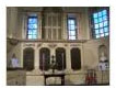
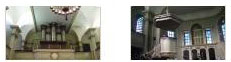
The magnificent interior of the Chapel is considered the finest example of Georgian church architecture in North America. Below are some thumbnails for pictures of the altar, the organ (over the entry) and the pulpit. Click on the thumbnails to see the full-size pictures:
|
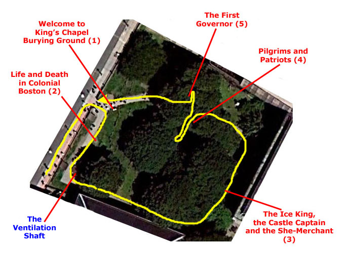
Immediately adjacent to the Chapel is the old burying ground from which the land for the chapel was taken.
|
|
|
The burying ground from which the land for the church was taken, is the oldest burying place in Boston proper. The burying ground is the final resting place for many colonists, including John Winthrop, the Colony's 12 term governor, Hezekiah Usher, the colony's first printer, and Mary Chilton, the first woman to step off the Mayflower. In fact, many of these people are listed on the commemorative markers at the entrance to the cemetery.
As I did for the Granary Burying Ground, I'd like to give you the opportunity to tour King's Chapel Burying Ground, read the informational signs and look at some of the grave markers. So below is an aerial view of the burying ground with the five informational signs indicated. Just click on the name of any sign to have a look at our picture of it and read the information on it. We didn't take many individual pictures of graves; the personages buried here were much less well-known historically. But we did take some interesting pictures around the burying ground, and you can click on the "names" of those pictures to have a look at them. Here is your clickable aerial view:
|
We took quite a few pictures here in the King's Chapel Burying Ground, and if you will click on the thumbnail images below you can have a look at some of the best of them:
|
We were done in the King's Chapel Burying Ground, so it was off again on the Freedom Walk.
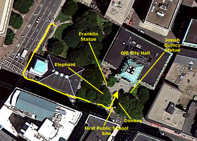
First Public School (Freedom Trail Stop #6)
|
The actual plaque identifying the site is across School Street on the wall of what is now the Parker House Hotel. (There was another marker nearby describing the Parker House- one of Boston's oldest lodging houses, and the oldest still operating as a hotel.)
Founded on April 13, 1635, Boston Latin is America’s oldest public school. Until the completion of the schoolhouse in 1645, classes were held in the home of the first headmaster, Philemen Pormont. The actual site of the school is in what is now the courtyard of the old Boston City Hall- near the statue of noted alumnus Benjamin Franklin.
Four signers of the Declaration of Independence attended Boston Latin: Franklin, Samuel Adams, John Hancock, and Robert Treat Paine. But of the four, only three graduated: Ben Franklin, though one of America’s greatest minds, is also one of its most notable high school dropouts. Marking the association, the statue of Franklin, sculpted by Richard Saltonstall Greenough in 1856, is installed in front of the building now occupying the site. (Franklin's birthplace was just one block away on Milk Street, across from the Old South Meeting House.) The original wooden school building was torn down in 1745 to make way for an expanded King’s Chapel; you can see the back of the chapel encroaching on the site here.
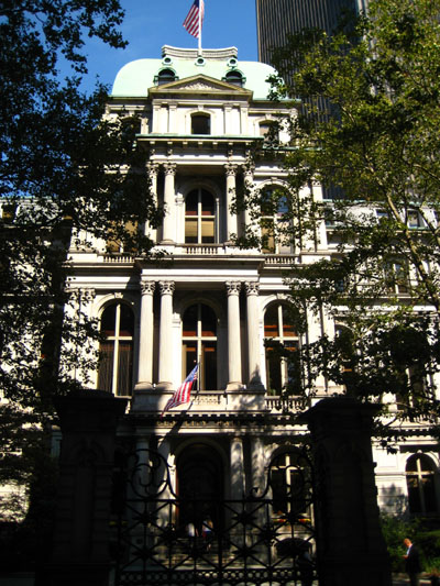
The building now occupying the site is Boston's third City Hall. In 1810, the Suffolk Country Courthouse was erected here, and, in 1841, that courthouse was converted to Boston's second city hall. In 1865 it was replaced by Boston's third city hall, the building we see here today. A hundred years later, in 1969, Boston built its fourth city hall at Government Center and vacated this site.
|
Thirty-eight Boston mayors served their terms of office on School Street at this site over a period of one hundred and twenty-eight years. All twenty of the Democrat mayors adopted the donkey as their party's symbol, while only five of the ten Republican mayors utilized the elephant.
In 1828, Andrew Jackson established the Democratic party and ran for President using the populist slogan, "Let the people rule." His opponents thought him silly and labeled him a "jackass." Jackson, however, picked up on their name-calling and turned it to his own advantage by using the donkey on his campaign posters. Over the years this donkey has become the accepted symbol of the Democratic party. A life‑size bronze of a donkey is located here in the courtyard.
The symbol of the Republican party was born in the imagination of a cartoonist, Thomas Nast, in Harper's Weekly in the 1870s. Soon other cartoonists used the elephant to symbolize Republicans, and eventually, Republicans adopted the elephant as their official symbol. No life-size elephant bronze is located here, oddly enough. What IS located here is a set of bronze footprints, with the elephant symbol and the inscription "Stand in Opposition."
There are two statues in the courtyard here. One is of Benjamin Franklin (1706-1790), who was born in Boston and attended school on this site as a boy before pursuing a distinguished career as an author, inventor, scientist, politician and statesman. Scenes of Franklin's accomplishments appear in bas-relief on the square pedestal of the statue. The statue (1856) was the first portrait statue to be erected in Boston. Franklin is depicted as he would actually appear, rather than draped in toga, cloak, or classical attire. The statue was designed by Richard Saltonstall Greenough, as are two of the bas-reliefs.
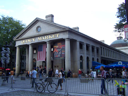
The other statue is of Josiah Quincy (1772-1864), who was the second Mayor of Boston and served six consecutive, one-year terms from 1823-1828. During his tenure he was reponsible for the development that expanded the produce and meat markets in Faneuil Hall into three new buildings known as the Quincy Markets. His statue (1879) was designed by Thomas Ball.
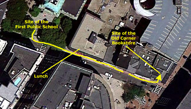
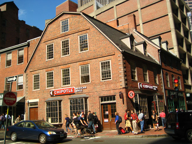
The Old Corner Bookstore (Freedom Trail Stop #7)
|
|
(If you look closely at the picture at right, you will see the corner of a green marker just behind the head of the person just to the left of the School Street doors at the corner. If you would like to read that marker, just click here.)
It opened in 1828 and flourished through 1903 under various proprietors. It peaked under the management of publisher Ticknor and Fields; they were the nation’s leading publishing house from 1833 to 1864. They produced the works of Henry Wadsworth Longfellow, Harriet Beecher Stowe, Nathaniel Hawthorne (The Scarlett Letter was printed here), Ralph Waldo Emerson (ditto for On Walden Pond), John Greenleaf Whittier, Oliver Wendell Holmes Sr., Charles Dickens and Louisa May Alcott. Many of these literary giants were frequent visitors to the building.
During the bookstore’s heyday the corner of School and Washington came to be known as Parnassus Corner, a reference to the mountain home of the Twelve Muses of Greek mythology, and the Atlantic Monthly magazine was produced here. The building was restored in 1960. The Old Corner Bookstore is one of Boston's oldest surviving structures. Today, as you can see, the building is occupied by a restaurant, with offices upstairs.
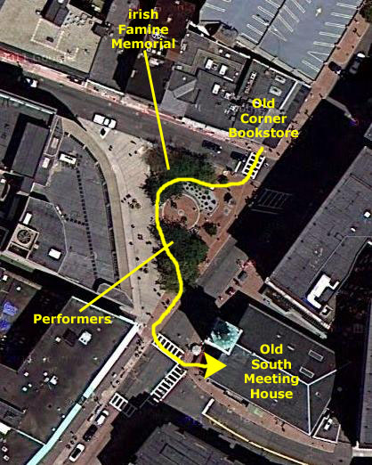
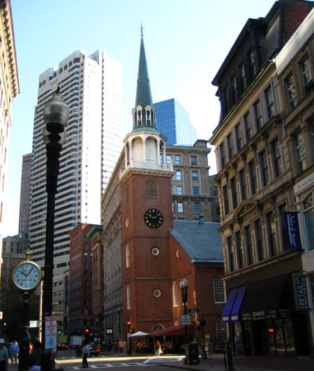
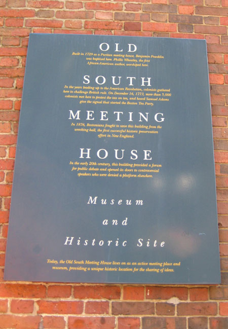
The Old South Meeting House (Freedom Trail Stop #8)
|
So we walked across School Street and past the Memorial (pictures of which you also saw earlier today) and made our way to the street crossing just in front of the Old South Meeting House. Just past the Memorial, we encountered some street performers, and we stopped to listen to them. I made a short movie of them and of the Bookstore and Meeting House, and you can watch that movie with the player below:
|
|
Then we crossed Washington Street to The Old South Meeting House. (I had to walk a little ways down Washington Street to get the whole building in a picture; that's the image I used below.)
|
On that particular day, over 30 tons of taxable tea sat in the holds of three ships, the Dartmouth, Eleanor, and Beaver, moored at Griffin’s Wharf. Not wanting to pay the onerous duty, thousands of Bostonians crowded into Old South Meeting House to take part in a heated discussion of what was to be done about the tax and/or with the tea. After the failure of a final attempt to have the tea sent back to England, Samuel Adams addressed the crowd saying, "Gentlemen, this meeting can do nothing more to save the country!"
These words were rumored to be a secret signal to a group called "The Sons of Liberty." Cries of "Boston Harbor - A tea pot tonight!" were heard throughout the hall, and men disguised as Mohawk Indians marched down to Griffin’s Wharf. There, members of the group boarded the three ships and, just as you learned it, dumped 342 crates of tea into the harbor- all while other meeting attendees and not just a few British watched.
The event, of course, became known as "the Boston Tea Party" and set that stage for the seminal event so far in American history. (That the name was also adopted in the first decade of the twenty-first century by a populist political movement can't tarnish the importance of the event itself.)
Today, the Old South Meeting House is a museum where visitors can view the reenactments of the Boston Tea Party debates (those from 1773, not 2011).
|
SOUTH
In the years leading up to the American Revolution, colonists gathered
here to challenge British rule. On December 16, 1773, more than 5,000
colonists met here to protest the tax on tea, and heard Samuel Adams
give the signal that started the Boston Tea Party.
MEETING
In 1876, Bostonians fought to save this building from the
wrecking ball, the dirst successful historic preservation
effort in New England.
HOUSE
In the early 20th century, this building provided a forum
for public debate and opened its doors to controversial
speakers who wre denied a platform elsewhere.
Museum
and
Historic Site
museum, providing a unique historic location for the sharing of ideas.
|
|
I did make a movie looking around in the lobby of the Meeting House, and continued filming as I walked out the doors and back onto Washington Street, where you can see the Bookstore and the Irish Famine Memorial. You can watch that movie with the player at left.
When we got back outside and were ready to continue following our trail of red bricks down the street to the next place of interest, we noticed that there was a small produce market set up at the corner of the building. I can only imagine that this is with the approval of the Museum.
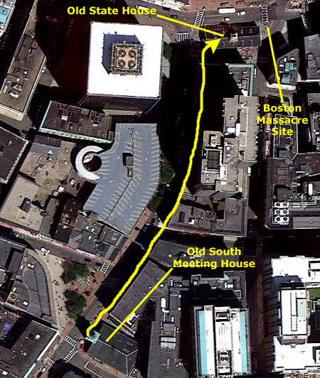
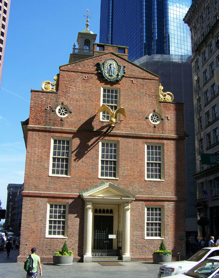
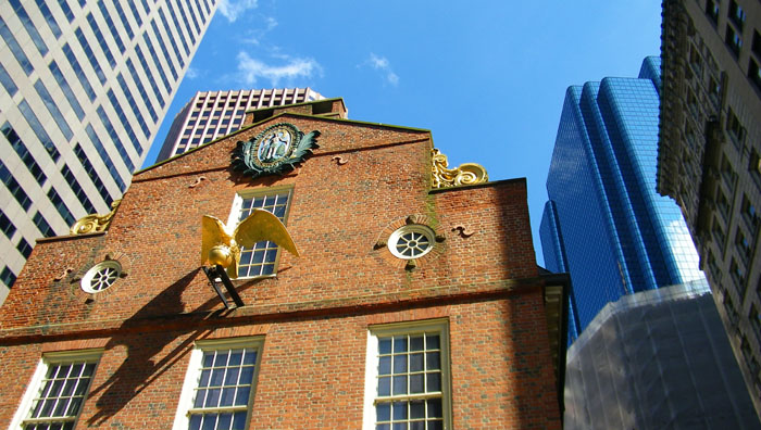
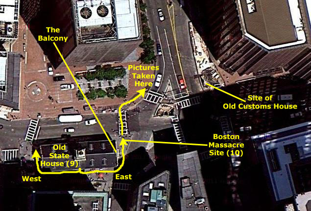
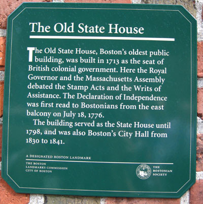
The Old State House (Freedom Trail Stop #9)
|
|
The Old State House, the oldest surviving public building in Boston, was built in 1713 to house the government offices of the Massachusetts Bay Colony. It stands on the site of Boston's first Town House of 1657-8, which burned in 1711. The Old State House was a natural meeting place for the exchange of economic and local news. A Merchant's Exchange occupied the first floor and the basement was rented by John Hancock and others for warehouse space. As the center of political life and thought in the colonies, the Old State House has been called one of the most important public buildings in Colonial America.
|
The central area of the second floor was the meeting place of the Massachusetts Assembly, one of the most independent of the colonial legislatures. This Assembly was the first legislative body in the colonies to call for sectional unity, and the formation of a Stamp Act Congress. Although no trace remains today, a visitor's gallery was installed in Representatives Hall in 1766. The gallery permitted citizens, for the first time in the English-speaking world, to hear their elected officials debate the popular issues of the day.
The building's west end was home to the Courts of Suffolk County and the Massachusetts Supreme Judicial Court for many years. The Supreme Judicial Court is the longest seated court in the nation (over 300 years old) and was responsible for the ruling decisions in many of the early landmark trials. The Court was also involved in the drafting of the Massachusetts Constitution, upon which the United States Constitution is based.
Official proclamations were read from the Old State House balcony, on the east side of the building, looking down State (formerly King) Street. The area beneath the balcony was the site of the Boston Massacre on March 5, 1770, when a handful of British soldiers fired into a taunting crowd, killing five men. Today a circle of paving stones marks the spot of the Massacre.
On July 18, 1776, the Declaration of Independence was first proclaimed from here, to the jubilant citizens of Boston. Later that day, the lion and unicorn, along with other symbols of royal authority, were taken down from the roof of the building and burned in a great bonfire in Dock Square.
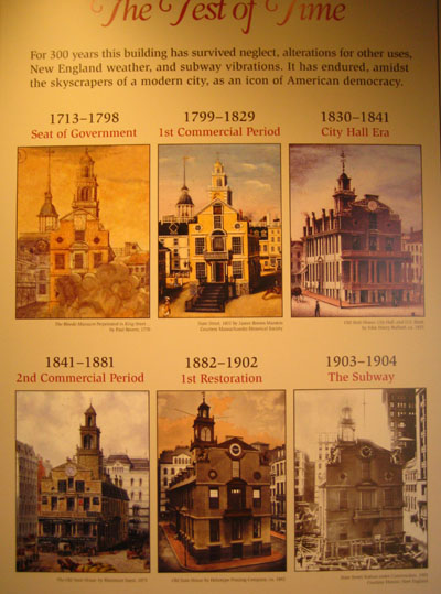
After the Revolution, the Old State House continued as the seat of Massachusetts government until a new State House was built on Beacon Hill. On January 11, 1798, all government functions left the building when the governor, state legislature, and other state officials moved to the new State House. From 1830 to 1841, the building was used as Boston's City Hall. In 1841, the building returned to commercial use. During the mid-nineteenth century, the building entered a period of decline, suffering many alterations made to accommodate its tenants.
|
From across Washington Street, I made a movie of the Old State House and the area surrounding it. It reminded me of the sequence in the movie The Time Machine that depicts the growth of Manhattan around the site of the turn-of-the-century brownstone in which the time traveler lived. You can watch that movie with the player below:
|
|
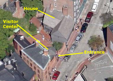
Today, the building is run by The Bostonian Society as a Boston history museum, and we thought that we would go inside and have a look around.
|
When we went in, we found that tours were available both for the museum and also for a visit to the site of the Boston Massacre. We opted for a combination of the two, and I was later glad that we did, once we had heard the incredibly interesting talk given in the second half of our tour at the Boston Massacre site.
The building itself was utilitarian inside, but had an incredible circular staircase right in the middle, with large rooms on either side. For our museum tour, we had a young woman as our tour guide, and the first thing she did was to take us into the former Royal Council Chamber on the east side of the building for an orientation. We had a chance to look at some of the exhibits in that room before she took us across to the other side of the building. She stopped at the circular staircase to talk about the history of the building itself, and the renovations and modifications that have bee made to it over the years.
|
|
I also made a movie of part of her talk as I pan around the room, and you can watch that movie with the player below:
|
|
When our tour guide was finished, she took us back to our starting point to hand us off to the next guide who would take us through the story of the Boston Massacre.
The Site of the Boston Massacre (Freedom Trail Stop #10)
|
|
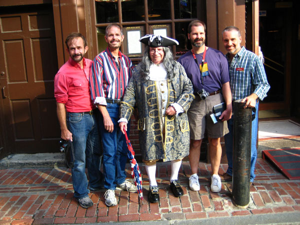
Then he took us outside and first to the west end of the Old State House where he began his explanation of the events leading up to the massacre. When we got our tickets, each of us had been given a little card to wear around our neck, and the card told us who we were in the large cast of characters of the event. For example, Fred was Ebenezer Richardson, a yeoman farmer and customs official. He asked each of us to raise our hands when we heard our character called out. I, as luck would have it, was Thomas Hutchinson, the Royal Governor- and not a very well-liked fellow by the Patriots. I did figure into the lead-up to the events, but wasn't involved in the actual shooting; that was the British soldiers under my authority but not my command.
|
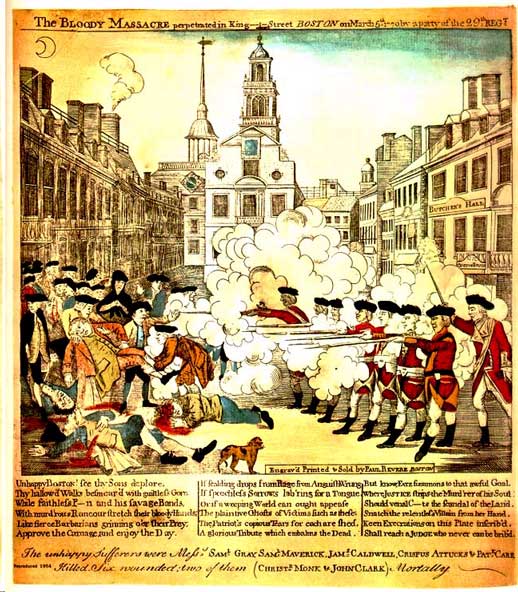
He took us from the west side of the building back around to the south side of the State House to bring us up to the afternoon of the event. Then we all went around to the east side of the building and stood under the balcony at that end of the building where official proclamations were usually read, right beside the fenced‑off site. Because of the construction, there were lots of people who had to walk between the State House and the fence, and at times they interfered with hearing his talk, but we stood close and didn't miss much. His main point was that the story we all learned wasn't entirely accurate, and the lack of accuracy was intentional on the part of the Patriots, who wanted to use the event as their own version of Pearl Harbor.
First, what was the story the Patriots told?
In 1770 tensions were high between Bostonians and Redcoats sent to Boston in the wake of the Stamp Act riots. Occasionally things would erupt into fist fights and angry confrontations. On March 5, Private White, on guard at the Custom’s house in King’s Street (now State Street) left his sentry box and struck young Edward Garrick in the face with the butt of his musket for insulting his commanding officer. (The insult had originated when Garrick was supposed to have taunted the officer by insinuating he was a deadbeat for not paying a local wigmaker.) White soon found himself surrounded by an angry mob that hurled taunts and snowballs at him.
Captain Preston of the 29th Regiment arrived with eight Redcoats to reinforce White. The troops forced their way through the increasingly hostile crowd, now swollen to several hundred people. Amidst a hail of snowballs and rocks, a club thrown from the crowd struck Private Montgomery in the face. Witnesses said Montgomery then fired the first shot. The crowd continued to press on the soldiers and more shots were fired. When the smoke cleared, five men lay dead or dying.
In that official account, the colonists were guilty of little more than taunting and some snowball throwing, and were punished by being "massacred" by the British soldiers. Samuel Adams held funerals for the victims and organized a vigorous propaganda effort, labeling the event a bloody massacre. (His second-cousin John Adams defended the soldiers in court and all but two were acquitted of all charges.) So it appears that the guilt of the British was far from clear. But the damage had been done; the colonists were enraged.
Our guide, using Revere's engraving as an example, redefined the event as an engineered propaganda tool. Supported by additional information, he related an alternative view of events.
First of all, the Boston Massacre was not really a massacre, but more like a riot. True, five people died, but it was hardly a massacre; that would imply that those killed had neither defense nor actions justifying the shootings. One of the most common myths is that the Boston Massacre was the event that led to the Revolutionary War. In fact, many important events led up to the massacre. It was called a massacre by the use of propaganda. It mainly started by the British trying to enforce laws.
British Soldiers were sent to America to enforce the Proclamation and to maintain order but their presence just made matters worse. It all started March 5 by a couple of boys throwing snowballs at British soldiers. A crowd soon gathered throwing ice and making fun of them. Soon after, the British started firing wildly. Other weapons were clubs, knives, swords, and a popular weapon, one's own bare hands. The purpose of the Boston Massacre was to try to make liberal and moderate people become radicals. It was really an accident and the radicals tried to use propaganda and turn something small into something big. The British soldiers were accused of murder and manslaughter. The Revere engraving had numerous inaccuracies, one of which was the depiction of other British soldiers firing from the windows of the Old Customs House; no evidence of such soldiers exists. The colonists were shown unarmed and cringing, and the British were shown with all the power and weaponry. So the truth was stretched- quite a bit- and that's what propaganda is.
|
|
From the other side of State Street, I could look back at the Old State House where our guide was still talking to a few people.
I also made a movie looking around the area where the massacre occurred, and you can watch that movie with the player at left.
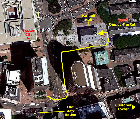
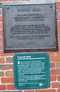
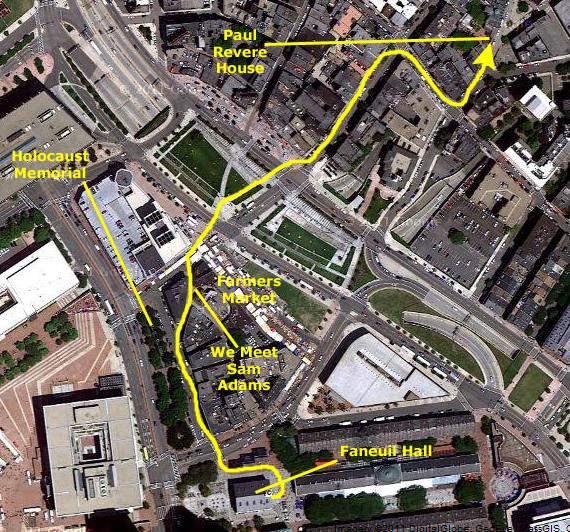
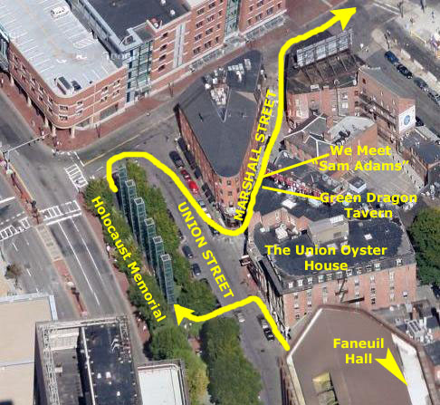
Faneuil Hall (Freedom Trail Stop #11)
|
We walked north along Congress Street for a block, until we came to the Boston National Historical Park, just across Congress Street from the current Boston City Hall at Government Center. Then we turned right through the park along the south side of Faneuil Hall, and came to the front of the Hall between it and the Quincy Market. You can follow our path on the aerial view at left.
The first thing one sees when arriving in front of Faneuil Hall is the three buildings that make up the Quincy Marketplace. The market area began with Faneuil Hall, which was a gift to the city from its wealthiest merchants. But by 1825, the Hall had outgrown its market function, and it was expanded to include a new building, called Quincy Market in honor of Boston Mayor Josiah Quincy. The Greek Revival style building was later augmented with two additional buildings- North Market and South Market.
The area had fallen into some disrepair by the 1970s, and in that decade, along with the establishment of the Freedom Trail, the market area was refurbished and updated and is, today, a thriving market and entertainment center. There were certainly a lot of people around when we were here.
|
|
|
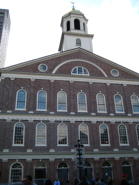
Christened the Cradle of Liberty, Faneuil Hall's vital role in revolutionary politics hadn't been part of its original plans. Peter Faneuil, a wealthy merchant, built the hall as a center of commerce in 1742. He also hired a local artisan to create the grasshopper weather vane that still perches on the building's cupola. While the market stalls on the first floor house successful shops to this day, it is the second floor meeting hall that has the greater legacy.
|
|
Following the Revolution and to this day, Faneuil Hall retained its position as a stage for debate. In 1763, the Hall burned down, but it was rebuilt almost identical to its original plan. In 1805, Charles Bulfinch redesigned the current building and an expansion was completed in 1806. When Boston became a city the use of Faneuil Hall as a government meeting place came to an end, but it was still regularly used. Today, the first floor is still used as a lively marketplace and the second floor is a meeting hall where many Boston City debates are held. The fourth floor is maintained by the Ancient and Honorable Artillery Company.
The building was open, so the four of us went inside. We bypassed the first floor, where some of the market is, and went directly into the meeting hall.
|
|
The inside of Faneuil Hall was very handsome; the hall is also very well laid out for meetings, discussions and debates. There is a stage at the west end of the room, chairs and benches on the main floor, and two levels of galleries on either side.
There is a great deal of artwork all around the hall, including more than ten busts of historic figures. Some of the people honored with sculpture are John Quincy Adams, Frederick Douglass, John Adams, Lucy Stone and Daniel Webster. There were also paintings almost too numerous to mention. Over the stage, for example, there was a huge painting entitled "Webster Replying to Hayne" that depicts Daniel Webster as a Massachusetts Senator debating South Carolina's R. Y. Hayne in the Senate Chamber in Washington on January 27, 1830, saying that the Union must be preserved. The canvas was painted between 1846 and 1850 by George Healy.
Other works that we took pictures of included a copy of Gilbert Stuart's 1806 portrait of George Washington and a portrait of Peter Faneuil. This particular portait was a copy of the original 1742 work by John Smibert that was painted in 1807 by Henry Sargent, one of the United States' most notable portrait painters.
We enjoyed sitting down and listening the the building tour guide for a little while before heading off along the Freedom Trail.
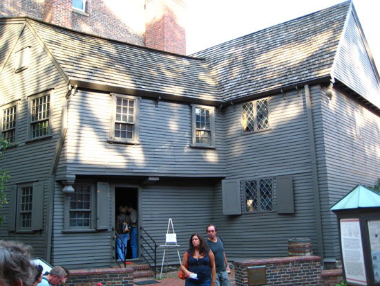
The Paul Revere House (Freedom Trail Stop #12)
We left Faneuil Hall and went around the north side of the building, through a small park, and across North Street. Then we walked along Union Street and past some very old taverns and public houses- some of them in buildings dating from the Revolutionary War period.
|
Beginning in 1771, printer Isaiah Thomas began publishing his newspaper "The Massachusetts Spy," long known as the oldest newspaper in the United States. In 1775, Capen's became headquarters for Ebenezer Hancock, the first paymaster of the Continental Army. There is no reason to doubt that Washington himself was familiar with its surroundings. During the revolution the Adams, Hancock, and Quincy wives, as well as their neighbors, often sat in their stalls of the Capen House sewing and mending clothes for the colonists.
In 1796, a future king of France lived on the second floor. Exiled from his country, he earned his living by teaching French to many of Boston's fashionable young ladies. Later Louis Phillippe returned home to serve as King from 1830 to 1848. 1826 marked the end of Capen's Dry Goods Store and the beginning of the Atwood and Bacon Oyster House. Daniel Webster was a constant customer. The Union Oyster House was the first restaurant to offer patrons toothpicks; Charles Forster of Maine first imported the picks from South America, and hired boys from Harvard boys to dine there and ask for them. Since 1826, the restaurant has had only three owners, the latest having taken over in 1970.
|
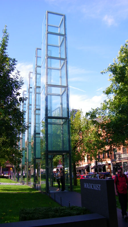
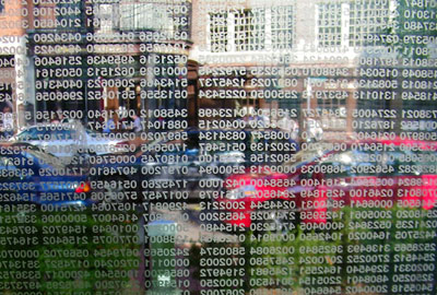
|
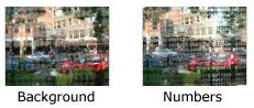
All in all, there are some six million numbers inscribed on the glass panels (although the numbers are not unique). At first we thought they were actual prisoner numbers, like the tattoos you see occasionally in movies or on television on the skin of holocaust survivors, but this turned out not to be the case.
It was interesting, looking through the panels, and even more so to photograph them. I stood inside one of the glass towers to take two pictures through a particular panel. In the first one, I focused on the background, and in the other on the numbers. Click on the thumbnails below to see how these two pictures turned out:
|
At the beginning of the walkway that goes through and under the glass towers, there is a memorial marker with a timeline of holocaust events. That sets the stage for one to walk through the glass towers. At the end of the walk, there was another granite marker, this one with the famous quote from Martin Niemoller. I have not been to many of these memorials, although I know there are quite a few of them. This one was well done, I thought, and undoubtedly makes a definite impact on the visitor.
|
|
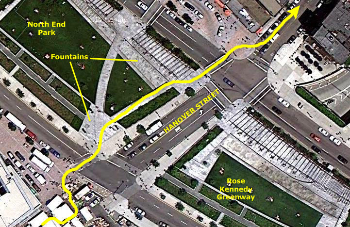
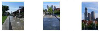
At the end of the short Marshall Street, we turned right on Hanover Street towards The North End- Boston's Italian area and the continuation of the Freedom Trail. I should note that we are still following the line of red bricks, which has been installed in sidewalks old and new, and which is painted when it crosses streets. As we approached the former route of Interstate 93, we passed through a farmer's market. Whether this is an everyday occurrence or just a weekend thing, I am not sure, but we lost the trail for a while but picked it up again on the other side of the rows of vendor booths. By then, we were at the south edge of what is now known as "The Rose Kennedy Greenway."
By far the biggest physical alteration to Boston in history was not some new building or arena. It has to be the removal of the old elevated Interstate 93, which used to run right through downtown Boston, and which involved also an elevated interchange with Interstate 90 as well as the two tunnels to Logan Airport.
By the 1980s, the steel superstructure of the elevated highway had deteriorated significantly, and, in addition to that, the highway had become the city's biggest eyesore. After much discussion and wrangling, the State of Massachusetts, in partnership with the Federal Government, undertook the largest civilian construction project in U.S. History- a project called "The Big Dig."
|
The Freedom Trail went along Hanover Street through the farmers' market, and then across the greenway.
|
|
|
After we crossed the greenway, and Cross Street which runs along its north side, we could look back and get very nice views of downtown Boston in the afternoon light.
|
|
|
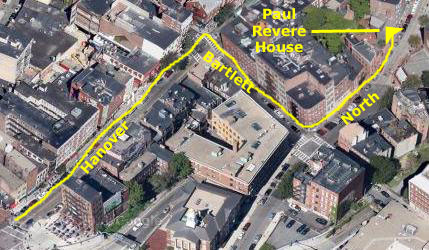
When we got to Bartlett Street, the bricks crossed and then turned left to take us a block east to North Street. There, they turned north again and in just a few hundred feet we were at the entrance to the Paul Revere House. Just inside the entrance there was a large sign with details about the house and floor diagrams. You can have a look at that sign here.
|
|
The home was built about 1680 on the site of the former parsonage of the Second Church of Boston. Increase Mather, the Minister of the Second Church, and his family (including his son, Cotton Mather) occupied this parsonage from 1670 until it was destroyed in the Great Fire of 1676. A large and fashionable new home was built at the same location about four years later.
The first owner of the new two-story townhouse on North Square was Robert Howard, a wealthy merchant. By the mid-eighteenth century, the front roof line of the building had been raised and a partial third story added. Paul Revere purchased the home in 1770, moving his family here from their Clark's Wharf residence. The former merchant's dwelling proved ideal for Revere's growing family, which in 1770 included his wife, Sarah, five children, and his mother Deborah.
|
|
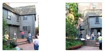
Paul Revere owned the home from 1770 to 1800, although he and his family may not have lived here in some periods in the 1780s and 90s. After Revere sold the home in 1800, it soon became a tenement, and the ground floor was remodeled for use as shops, including at various times a candy store, cigar factory, bank and vegetable and fruit business. In 1902, Paul Revere's great-grandson, John P. Reynolds Jr. purchased the building to ensure that it would not be demolished. Over the next few years, money was raised, and the Paul Revere Memorial Association formed to preserve and renovate the building. In April 1908, the Paul Revere House opened its doors to the public as one of the earliest historic house museums in the U.S.
|
The heavy beams, large fireplaces, and absence of interior hallways recall colonial living arrangements. Many of the furnishings you will see in my movies are original and belonged to the Revere family. Our tour of the house was self-guided, but there were docents around to answer questions. Photography was not allowed, although I was able to take four short movies inside the house. Narrating wasn't possible, so I've just labeled each movie with its location in the house. You can watch these movies with the players below:
|
|
|
|
|
|
In the courtyard of the home (probably a later addition when the home was opened for tours) there is an exhibit that features a 900-pound bell, a small mortar and a bolt from the USS Constitution, all made by Paul Revere & Sons. If you like, you can read the description of the exhibit here.
The tour was interesting, but we have further to go along the Freedom Trail. Our next stop: "One if by land, two if by sea."
The Old North Church (Freedom Trail Stop #13)
|
|
|
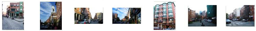
The North End has always been an interesting place; I have been here numerous times when on business trips to Boston in the past. It is one of my friend Tony's favorite places to come and eat, and I have joined him more than a few times. On our way to Paul Revere Mall (which leads to the Old North Church), the three of us took a number of pictures of North End street scenes. You may be interested in seeing some of the best of them; just click on the thumbnails below to do so:
|
Going up Hanover, we came to the eastern end of Paul Revere Mall. This urban park, named after the American patriot and adorned with a famous large bronze statue of him in the center of the mall, retells the story of some of northern Boston's most famous sons. The mall is located between two famous churches, the Old North Church, where Paul Revere had the now famous lanterns hung to alert nearby citizens of the British advancement, and St. Stephen's Church. The mall is lined by trees on either side and brick walls, and on the walls are bronze plaques that give more of the history of old Boston.
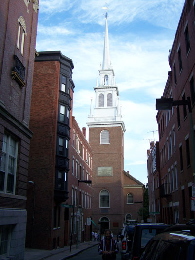
We turned west and walked the length of the mall, passing the Paul Revere statue and a fountain before coming to the back gate of the Old North Church. We walked through a small garden and around to the front of the church to have a look at it.
Christ Church in the City of Boston, also known as Old North Church, is the oldest standing church building in Boston, having first opened its doors to worshippers on December 29, 1723. Its 191‑foot steeple is the tallest in Boston and because of its prominence would play a dramatic role in the American Revolution. The steeple has been blown down twice by hurricanes, in 1804 and in 1954. The bells within the steeple were the first bells ever brought to America, and a young Paul Revere was one of the neighborhood bell ringers.
|
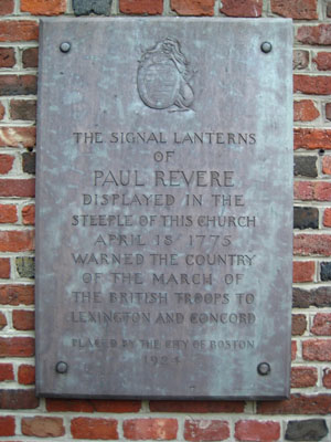
With tensions between the colonies and Britain high, the Royal Governor had ordered the confiscation of the weapons that the Colonists had been storing throughout the countryside. This had been tried before, but the Sons of Liberty, of which Paul Revere was a member, had alerted the people to British troop movements. The munitions were successfully hidden and the British troops were humiliated. General Gage, the Commander of British forces in North America and a parishioner at Old North, decided to seize the weapons and ammunition at Lexington and Concord, so he planned in secret. On the evening of April 18th, 1775, he would order his British soldiers cross the Charles River and march the remaining 15 miles to Lexington under the cover of darkness, arrive at sunrise to collect the armaments and return to Boston before the townspeople could organize their resistance.
|
Newman agreed to help, and that night entered the steeple through a doorway that is now behind the organ and climbed the 14 stories in complete darkness. When he reached the very top, he lit and briefly held up two lanterns in the steeple window. Although Newman hung the lanterns for probably less than a minute, it was long enough to be seen not only by the patriots, but also by the British troops. As Newman was coming down the stairs, British soldiers were at the front doors, trying to break in to investigate. To escape arrest, Newman came down the center aisle, and escaped through the window to the right of the altar. It is now called the "Newman" window in his memory. Above the window is the replica of Newman's lantern that was lit by President Gerald Ford on April 18, 1975, to begin our nation's Bicentennial Celebration. So it was from here, General Thomas Gage's own church, and the King's own church, the signal which ignited the American Revolution was sent.
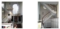
The interior of the church is Georgian Classic, and features high box pews and brass chandeliers. They, and the Church's first clock, are all original. The chandeliers were frowned upon by the Puritan/Congregationalists (the denomination of the colonists) because they were ostentatious displays of wealth. The installation of the organ was another symbol of the perceived decadence of the English Church; Puritans forbade structural music in their meeting houses.
|
|
|
Today, church visitors can sit where they like, but at the time of the Revolution, members of the congregation would have had to purchase their box pews if they wanted to worship here. Different pews had different prices; those on the center aisle would have cost significantly more than those on the sides or in the galleries on the second level. Families, as long as they kept up their pew rents, had exclusive use their pew and would decorate them to their own tastes with fine fabrics and furniture; these decorations and where families sat were indications of a family's social status. Many accounts exist in which a family might begin in a back pew but continually move forward or to the center as pews opened up and their finances permitted. (General Gage, only recently arrived on a tour of duty, had to sit in the far back pew.)
After we visited the Old North Church, it was off to our last Freedom Trail stop for today.
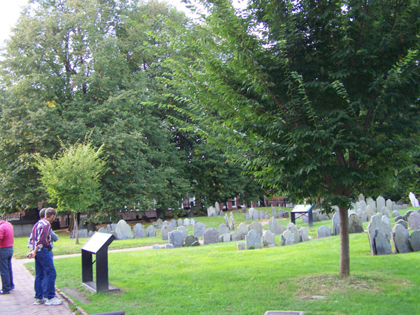
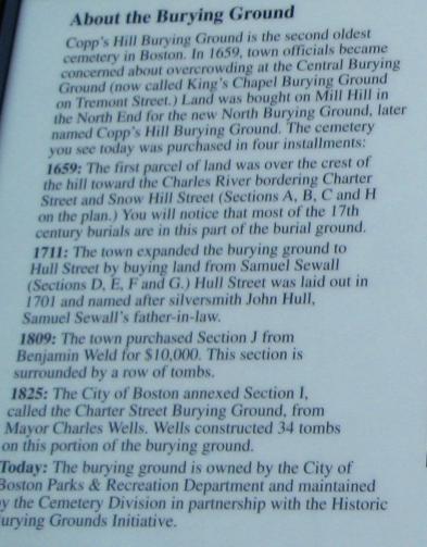
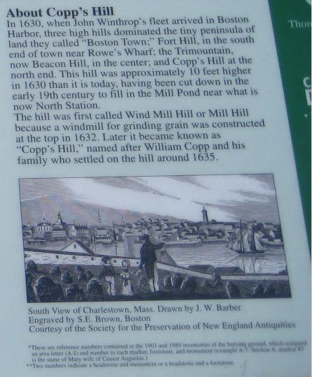
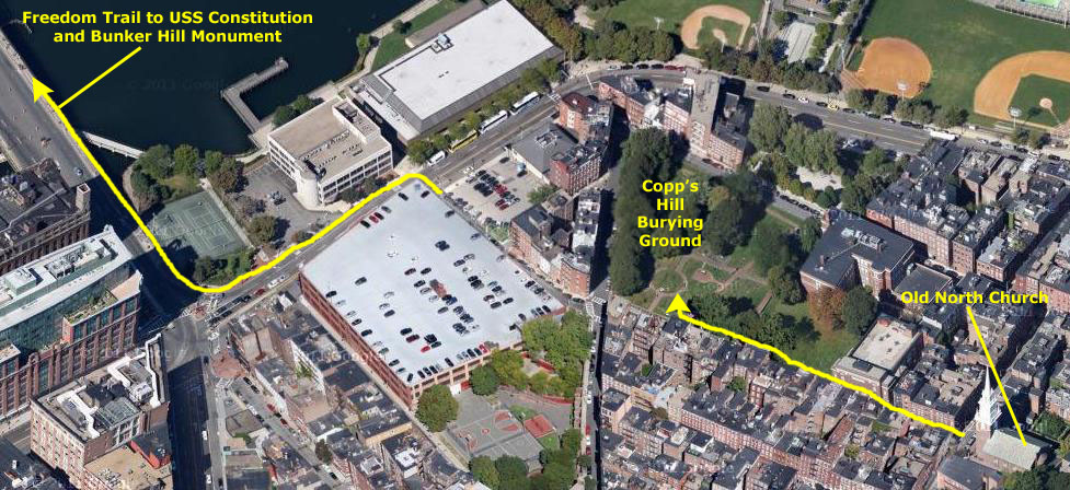
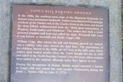
Copp's Hill Burying Ground (Freedom Trail Stop #14)
|
I might point out in the aerial view above that from the burying ground, the Freedom Trail continues across the Charles River on one of Boston's signature bridges to the last two stops- the USS Constitution and the Bunker Hill Monument. We could easily tell that there would not be time today to walk across the river and see those two places, so we are going to save them until tomorrow. And, tomorrow, we will just park near one of them, so we won't have a chance to cross the bridge on foot at all.
|
|
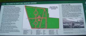
We learned quite a bit from the sign, and I thought I would expand it in sections so you could read it too.
|
Thousands of artisans, craftspeople, and merchants are buried on the Hill. Additionally, thousands of African Americans who lived in the "New Guinea" community at the base of Copp's Hill are buried in unmarked graves on the Snowhill Street side.
Also interred at Copp's Hill are the Mather family of ministers; shipyard owner Edmund Hartt; Robert Newman, best know for placing the signal lanterns in the steeple of the "Old North" Church on the eve of the Battle of Lexington and Concord; Shem Drowne, the weathervane maker who crafted the grasshopper atop Faneuil Hall; and Prince Hall, the anti-slavery activist and founder of the Black Masonic Order.
Below is a diagram of the burying ground, and below that a list of some of the notable gravesites found here.
|
| |
|
|
Because of its height, the British used this vantage point to train their cannons on Charlestown during the Battle of Bunker Hill in 1775.
|
|
|
Our visit to Copp's Hill Burying Ground completed our first major part of the Freedom Trail; it was all we had time for today. But tomorrow, we'll complete the Trail.
Dinner in Boston
|
|
After we crossed the Greenway, we went back through the farmers' market, where I made a movie of the activity, and you can watch it with the player at left.
We had dinner at one of the restaurants along Marshall Street near the Holocaust Memorial; I think it was right next to the Quincy Oyster House. With the nice weather, all the front windows were open, and even though we didn't sit right by the window, we had a good view of the passers-by as we ate.
After dinner, we walked back along the Freedom Trail as far as Faneuil Hall. There, using Customs House Tower as a guide, we followed our noses to get back to the parking lot where we'd left the car. Along the way, we did pass at least one interesting building, which I assume was at one time the U.S. offices of the Cunard Line- the British steamship company.
We collected the car with no problem and, fulfilling a promise I'd made Fred earlier in the day, drove back over to the North End so he could stop at Boston's most famous bakery- Mike's- for a couple of treats to take home. Getting back on I-93 was easy and we were back at the hotel 45-minutes later.
Additional Boston Pictures
|
To view the slideshow, just click on the image at left and I will open the slideshow in a new window. In the slideshow, you can use the little arrows in the lower corners of each image to move from one to the next, and the index numbers in the upper left of each image will tell you where you are in the series. When you are finished looking at the pictures, just close the popup window.
You can use the links below to continue through the New England trip or return to the New England trip Index Page to continue to another event/trip for 2011.
|
October 1, 2011: Walking Around North Boston |
|
September 29, 2011: The New Hampshire State House |
|
Return to the Index for our New England Trip |