|
May 22, 2017: A Guided Tour of East and West Berlin |
|
May 20, 2017: An Evening in Berlin |
|
Return to the Index for Our Visit to Berlin |
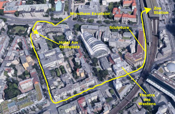
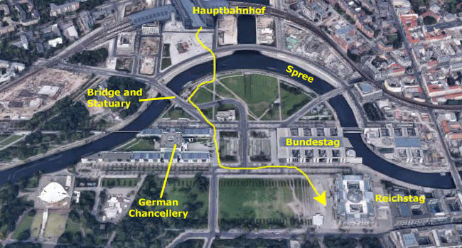
Today Fred and I will be on our own as Prudence, Nancy, Ron, and Karl don't arrive until late in the afternoon. We decided to first learn about the transportation system and then head over towards the Brandenburg Gate to walk around that part of the city. Since Prudence was having us stay at the hotel they had booked- the Hotel Am Steinplatz around the corner- we went ahead and checked out of the Wyndham and took our bags over to the Steinplatz to store them with the bellperson.
Hauptbahnhof: Berlin's Main Train Station
|
One street east of the street we walked down to get to Kant Strasse was the location of a cigar bar that Ron found; I think he bought a few cigars there and maybe smoked one at their bar.
In addition to that, Prudence (and Nancy sometimes and Fred sometimes and me sometimes) took her morning walk in this area, although she also went further west and further south. This morning was the only time we went to the train station via this route, though. The route down Hardenberg Strasse was shorter, and this was a factor for Karl and Nancy.
The route to the station looks easy on the aerial view, and it was easy once we got familiar with the neighborhood, but this morning we were just following our noses to get there.
|
|
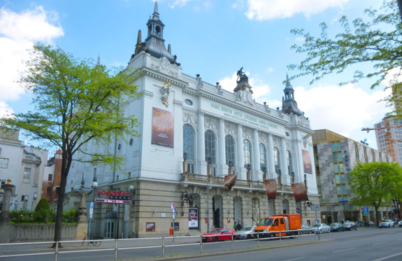
The theatre has operated continuously since the 1930s, although it closed for a time towards the end of World War II. After the war, it was for a time Berlin's only opera house, but when a new opera venue was built, it began to stage musicals and musical comedies, and has become the Berlin equivalent of a Broadway theater.
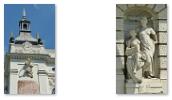
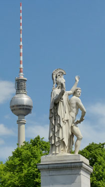
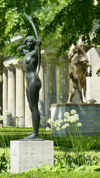
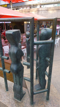
We continued up Kant Strasse, and at the point where the S-Bahn crossed over the boulevard, Fred took a picture of me with a bridge sculpture. We crossed Kant Strasse and followed the wall of the train viaduct towards the station, passing this interesting sculpture along the way.
At the station, we watched some Berliners working the automated ticket kiosk, and figured most everything out- particularly after a kindly Berliner showed us where to tap the screen to change the display from German to English. We were able to discover that seniors (60+) could buy the discounted tickets, and we also learned that if you are planning to ride more that two distinct times in a day, that the day ticket is a better deal than buying tickets by the trip. We filed all this information away for later, got our day tickets, and headed up to the train platform. There, the display told us that the next train for Hauptbahnhof would only be a minute or two, so I tried my hand at reading the posted timetable. Here in the center of Berlin, all the trains stop at all the stations around the inner circle, even if their final destinations in the suburbs are different. So for us, we could always just take the next train, but if we were going, say, to Potsdam out in the eastern suburbs, we would need to wait for a train with that destination (or change trains at some other station). This made our travel inside Berlin easy and quick.
|
 |
Our train would come into the station from the left (south) and would continue on around Berlin to the right. We will see some of that part of the line a little later on, but this morning we got off the train at Hauptbahnhof and were greeted with the largest train station (and largest transportation hub) either of us had ever been in. It was, in a word, amazing. It was almost as if the train had let us off right in the middle of a huge, multi-level shopping mall, and, indeed, there were so many stores and restaurants on all the levels that you might easily forget you were in a train station at all.
|
I headed off ahead of Fred; that't me in the plaid shirt ahead of Fred down the platform. I was following the signs directing me to the exit- or "ausgang", as the Germans put it, when talking about an exit for people, as from a building, for example. (While we use the same word, "exit", even when we are talking about an exit for vehicles (as in a freeway "exit"). The Germans, however, have a different word for that- "ausfahrt".
Anyway, when we went down the escalator, I was expecting something like the Zoo Station near the hotel, where the escalator would take us down to ground level and out to the street. I was not quite prepared for where the escalator did take us.
We would find out later that most European cities have a single "main" train station. If they have a metro or surface trains, as in Berlin, this main station will not only be a stop on those systems but also the station from which the intercity trains will leave. I already knew that the Hauptbahnhof was Berlin's current main station, but I didn't know that "haupt" loosely translates to "central" and that the German word for station is "bahnhof"; I had thought that the station was named for someone. But other German cities also have their own Hauptbahnhof, since that just means "central station". Had I known all this before going downstairs, I might not have been as surprised as I was.
|
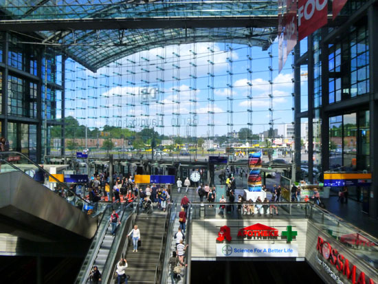
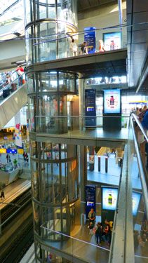
At the bottom of the escalator, we found we'd only come down one level, and looking further down we could see that the station descended another four levels down. The entire station was a huge, glass-enclosed space; the only permanent openings were the ones the trains used to enter and leave the station. But things were arranged so that even if it were raining heavily outside, or if it were cold and snowy, none of that weather would intrude more than ten or fifteen feet into the covered platform areas, and certainly now downstairs into the atrium.
As soon as we got off the first escalator, we could see that it had deposited us on a mezzanine that ran almost completely around a gigantic enclosed space. To our left and right along this mezzanine were shops of all descriptions- many of the fast food places that commuters might find useful. We could look across to the other side of the station and see another mezzanine just like ours with even more shops. There were two walkways across the enclosed space to get from one side of the station to another.
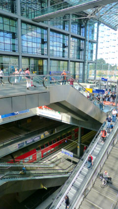
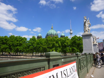
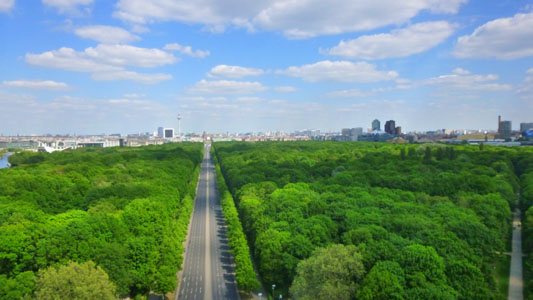
We took another set of escalators down another level and now we could look out either end of the station; both ends were walls of glass with some kind of framework to hold the panes of glass in place. The pictures at left and right were both taken on this next level down. In the picture at left, you are looking south towards the Reichstag and the Brandenburg Gate, and you can begin to get an appreciation for how big this space is.
|
Following heavy damage during World War II, limited services to the main station were resumed, but then suspended in 1951. In 1957, with the railways to West Berlin under the control of East Germany, Lehrter Bahnhof was demolished, but the extension station, called Lehrter Stadtbahnhof, continued as a stop on the S-Bahn. In 1987, it was extensively renovated to commemorate Berlin's 750th anniversary. After German reunification it was decided to improve Berlin's railway network by constructing a new north-south main line, to supplement the east-west Stadtbahn. Lehrter Stadtbahnhof was considered to be the logical location for a new central station.
In the picture at right, you can see the extent of the new station built to replace the Lehrter Stadtbahnhof as you look four more levels down to the lowest one, which we would learn later is the level where the long-distance intercity trains arrive and depart. That lowest level, 45 feet underground, has platforms served by new tunnels to Potsdamer Platz under the Spree and the Tiergarten, forming a new north-south line running to the northern part of the S-Bahn ring around central Berlin. Platforms for the planned extension to U-Bahn (subway Metro) line 5 are also found here. (There were supposed to be platforms for the Transrapid maglev train, but its construction was cancelled in the late 1990s.) You can also see more of the extent of the commercial operations here in the station.
So that, in essence, is what Berlin Hauptbahnhof is like. To summarize, there are two levels served by trains. The upper level, where we arrived, is served by six tracks, and on these tracks the Berlin S-Bahn (aboveground trains) arrive and depart. Also using this level are some intercity trains, but most of these are tied into the S-Bahn system and terminate in cities within 25 miles of the city. On the lower level one finds all the long-distance intercity trains as well as the Berlin U-Bahn (subway trains). The middle three levels are for commercial use, ticketing, ingress and egress to the station, and administration. Every day, some 2,000 trains pass through this station and almost a half million people pass get on or off one of those trains. It is its own 24-hour city.
|
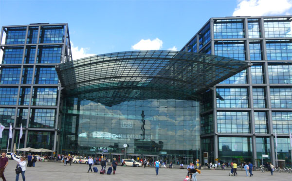
The view at left, which unfortunately does not get the entire building into the single shot, looks north at the station. You can see the arched ceiling over the track where we arrived protruding from the building on the right. Although the perspective may make you doubt it, the top of that curved glass ceiling is about on the same level as the top of the arched overhang on either end of the central part of the structure. Keep in mind that inside the building there are five levels; ground level is at the middle of those five levels.
The two taller structures at either side of the station house the commercial operations in the station (the top four levels sport all kinds of shops and stores and restaurants), station administration, commercial office space and the headquarters of Deutsche Bahn- the German Railway conglomerate. DB runs high speed ICE trains to domestic destinations like Hamburg, Munich, Cologne, Stuttgart, Frankfurt am Main and others. It also runs an SXF airport express rail service, as well as trains to several international destinations like Vienna, Prague, Z�rich, Warsaw, Budapest and Amsterdam.
So we have arrived at the station closest to the Reichstag, our first objective, and are going to head southeast to the other side of the Spree to see it. Before we leave the Hauptbahnhof, though, I have one more picture of Fred and the Hauptbahnhof.
The Reichstag and German Governmental Center
|
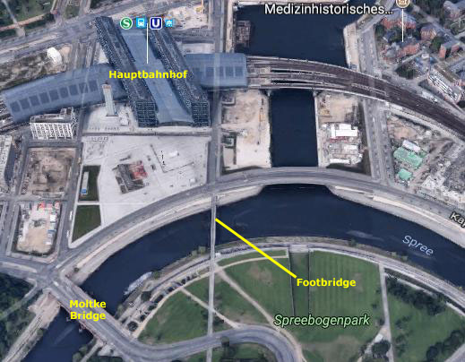
Walking south across the open plaza, we came to the pedestrian bridge across the Spree River.
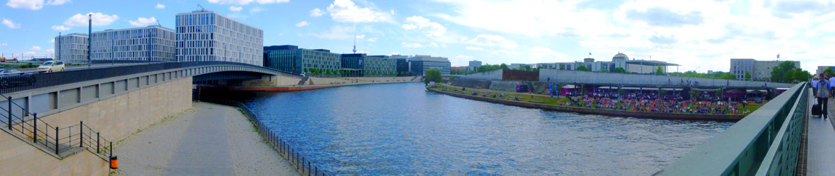
While I was standing on the north end of this pedestrian bridge, I thought I would create a panoramic view of the view to the east.
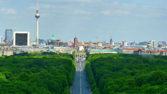
In my picture, constructed from three separate images, the Spree River is in the middle of the picture; there is a canal to the left that goes around north of the Hauptbahnhof and all the way past the airport (Tegel) to connect up with the Havel River. Those are new buildings on the other side of the canal; I am not sure what they are for, but I assume they are ministry buildings. The Fernsehturm (Television Tower) is in the distance; we will get closer to it later. You can also see the pedestrian bridge stretching away to the right and on the south bank of the river there are a group of restaurants and bars that set up lawn chairs for their patrons. This is a popular activity, as we learned, and it an often be hard to find a vacant chair. The dome of the Reichstag is in the distance, and some of the chancellery buildings at the right. Here is that panoramic view:
 |
Crossing the bridge, we turned to our right and walked a bit to the west along the south side of the River Spree. From this distance, we could get pretty good views of the entirety of the Hauptbahnhof (and you can see some of the cruise boats that go up and down the Spree- one of which we will ride on in a few days). We walked as far as the next bridge across the river.
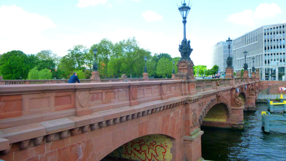 The Moltke Bridge |
Construction started in 1888 and was completed in 1891; for the next fifty years it was one of Berlin's most well-known bridges. The bridge was witness to heavy fighting during the Battle of Berlin in April 1945 at the end of World War II. German defenders, about 5000 members of the SS and Volksturm, barricaded the bridge at both ends and wired it for demolition. On April 28, units of the Soviet 3rd Shock Army, commanded by Major-General S.N. Perevertkin, fought their way down Alt-Moabit towards the bridge. Their goal was the capture of the German Reichstag, only 600 metres (about 660 yards) from the bridge. At dusk, the Soviets assaulted the bridge. The detonation charges damaged the bridge, with a section falling into the Spree, but enough stood for men and vehicles to cross. By midnight, the Soviet 150th and 171st rifle divisions had secured the bridgehead against any counterattack the Germans could muster. From here they moved on the Reichstag, which they captured on May 1.
Though damaged, the bridge was one of the few to survive the war and looks similar to the original construction, though it was repaired and strengthened to take the weight of modern traffic. Relatively new statues of mythical creatures adorn pedestals at either end of the bridge.
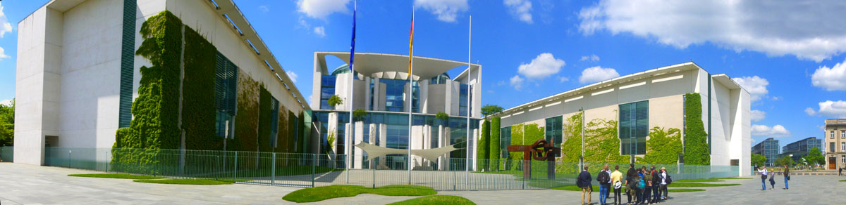
From the bridge, we followed the street that crossed the bridge southeast past the Swiss Embassy and to the west end of the German Chancellery (Bundeskanzleramt)- a very modern building with some interesting sculpture. The Chancellery's primary function is to assist the Chancellor in coordinating the activities of the federal government. The current Chancellery building (opened in the spring of 2001) was constructed of concrete and glass in a postmodern style. Covering four acres, it is the largest government headquarters building in the world. We were only looking at the east end of the building this morning, but we would see more of it during our river cruise. I thought my single picture of this end of the building didn't do it justice, so I constructed another panoramic view:
 |
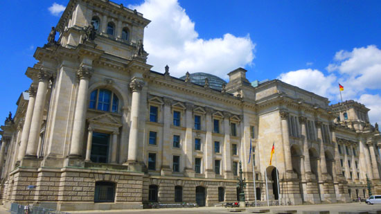
From the front of the Chancellery, we could see the Bundestag and the Reichstag across the wide lawn (actually a huge open space with almost nothing in it- no fountains, no statues, pretty much nothing). We crossed that lawn, passing by the new, modern Bundestag offices to the historic Reichstag.
|
The ruined building was made safe against the elements and partially refurbished in the 1960s, but no attempt at full restoration was made until after German reunification in 1990, when it underwent a reconstruction led by architect Norman Foster. After its completion in 1999, it once again became the meeting place of the German parliament: the modern Bundestag. (The building is still referred to as the Reichstag; the body that meets inside the Bundestag. The modern building just north of the Reichstag building, the one that actually spans the River Spree, is something like our House and Senate office buildings, as there is not enough space in the Reichstag building itself.)
The term Reichstag, when used to connote a diet, dates back to the Holy Roman Empire. The building was built for the Diet of the German Empire, which was succeeded by the Reichstag of the Weimar Republic. The latter would become the Reichstag of Nazi Germany, which left the building (and ceased to act as a parliament) after the 1933 fire and never returned; the term Reichstag has not been used by German parliaments since World War II. In today's usage, the word Reichstag (Imperial Diet Building) refers mainly to the building, while Bundestag (Federal Diet) refers to the institution.
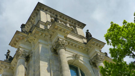
From our position in front of the Reichstag, we could look back across the lawn and see how large the Chancellery complex actually was; much of it was hidden when we were standing so close to the west face. We did not know it now, but the tour that we would be taking with the entire group tomorrow would begin here, at the Reichstag, and we would have a tour guide full of information about this building and the other sites where we would stop. So I'll wait until tomorrow for more about the building and its history. For now, here are three more pictures worth a look:
|
|
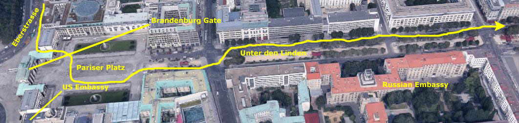
The Brandenburg Gate and Unter den Linden
 |
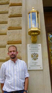
Walking down this street, Fred stuck his head into an archway into what looked like an office building's atrium, and then called me to follow him. In the courtyard we found the Hopfingerbrau Restaurant and this odd statue of a huge man with a much smaller figure at his feet. (I am the third figure in the picture.) I didn't see a label on the work, and have tried to find out what it represents, but have so far been unable to. Back out on the Eberstrasse, I took a picture of one of the worst eating places in Berlin.
|
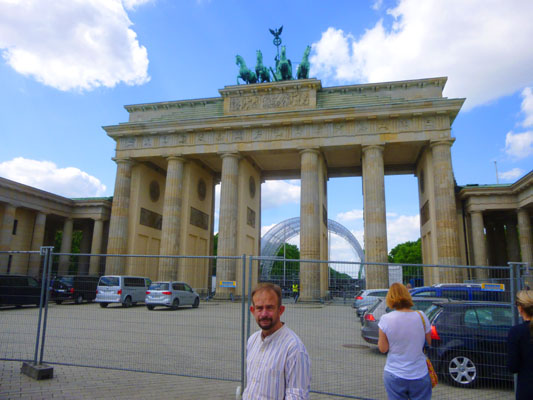
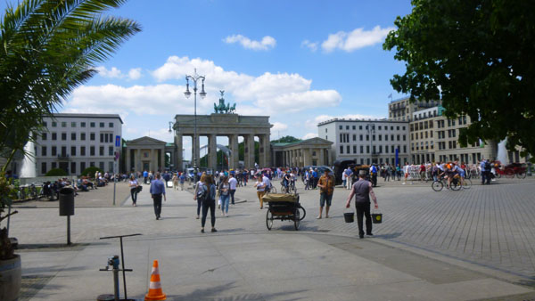
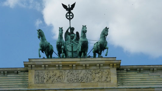
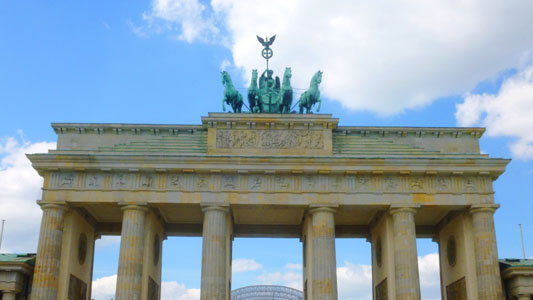
Sadly, with the upcoming event and all the fencing, really good classic pictures of the gate were pretty much impossible- at least today. Probably the best view is the one at left with Fred. It would have been better if I could have gotten that woman to move.
The Brandenburg Gate (Brandenburger Tor) is an 18th-century neoclassical monument, built on the orders of Prussian king Frederick William II after the (temporarily) successful restoration of order during the early Batavian Revolution in the 1780s. One of the best-known landmarks of Germany, it was built on the site of a former city gate that marked the start of the road from Berlin to the town of Brandenburg an der Havel, which used to be capital of the Margraviate of Brandenburg.
The Gate is located at the eastern end of the Tiergarten, at the junction of Unter den Linden and Ebertstrasse, immediately west of the Pariser Platz. It is the monumental entry to Unter den Linden, the renowned boulevard of linden trees, which led directly to the royal City Palace of the Prussian monarchs. Throughout its existence, the Brandenburg Gate was often a site for major historical events and is today considered not only as a symbol of the tumultuous history of Europe and Germany, but also of European unity and peace.
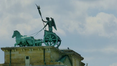
Both Fred and I had to use our zooms to get any decent pictures of the gate and its crowning quadriga:
 |
 |
Just to the east of the Brandenburg Gate is Pariser Platz, a central square here in Berlin. The square is named after the French capital Paris in honor of the anti-Napoleon Allies' occupation of Paris in 1814, and is one of the main focal points of the city.
|
The Brandenburg Gate was the main gate in the western side of the Customs Wall that surrounded the city in the eighteenth century, and the Pariser Platz is at the west end of the avenue of Unter den Linden, the ceremonial axis of the city, down which the victorious troops of all regimes from the Hohenzollerns to the German Democratic Republic have marched in triumph.
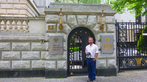
Before World War II, Pariser Platz was the grandest square in Berlin, flanked by the American and French embassies, the finest hotel (the Adlon Hotel), the Academy of the Arts, and several blocks of apartments and offices. During the last years of World War II, all of the buildings around the square were turned to rubble by air raids and heavy artillery bombardment. The only structure left standing in the ruins of Pariser Platz was the Brandenburg Gate, which was restored by the East Berlin and West Berlin governments. After the war and especially with the construction of the Berlin Wall, the square was laid waste and became part of the death zone dividing the city.
When the city was reunited in 1990, there was broad consensus that the Pariser Platz should be made into a fine urban space again. The embassies would move back, the hotel and arts academy would be reinstated, and prestigious firms would be encouraged to build round the square. Under the rules of reconstruction, eaves heights had to be 22 meters, and buildings had to have a proper termination against the sky. Stone cladding was to be used as far as possible. Interpretations of these constraints, however, have varied to a great extent.
I made two movies here in Pariser Platz, and you can use the movie players below to watch them:
|
|
Pariser Platz wasn't huge, but it was large enough to accommodate all the tourists who flock to the gate as well as groups doing just about everything; there was a circle of people today seated in the center of the plaza calling attention to violence against women, and there were a couple of folks who had brought antique vehicles to the square. You saw him in one of the movies above, but here is a still image of Fred and the fountain in front of the Berlin Academy of the Arts.
So we began walking east down the Unter den Linden ("under the linden trees"), one of Berlin's grandest avenues. Running from the City Palace to Brandenburg Gate, it is named after the linden trees that line the grassed pedestrian mall on the median and the two broad carriageways. The avenue links numerous Berlin sights and landmarks.
|
We passed a number of interesting buildings on the first part of our walk down Unter den Linden from the Gate to the Wilhelm Statue, and we saw a couple of oddities. One was this "stretch" Trabant. We'll find out more about the Trabant tomorrow on our guided tour, but for now you should know that it was the one car actually manufactured in East Germany before unification, and it had a terrible reputation. It has become a cult object now, though; we'll actually walk past the Trabant Museum tomorrow. Some people have kept these cars in the best condition possible, and there are enthusiast clubs devoted to them. Trabant never made a "Limousine" version like the one parked here; someone has constructed this one our of one or more actual Trabants.
|
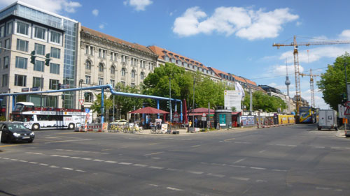
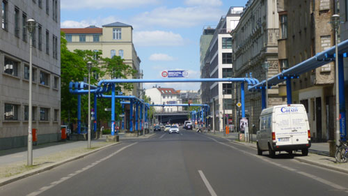
A little further down Unter den Linden, we came to a point where there was apparently some construction going on in the median (an expansion of the U-Bahn system, apparently). But we saw all these blue pipes around the site, and when we looked down one of the side streets, we saw a complex system of these same pipes:
|
|
It wouldn't be until our guided tour tomorrow that I would have a chance to ask someone what all these pipes were (and we saw more of them on that tour). Were they art? Were they part of some steam-heating system? Well, as it turns out, construction project excavations in Berlin typically encounter one of two problems- either there is water that has to be pumped out or, conversely, the ground is too dry and some water needs to be brought to the site (some of that for boring equipment). So the pipes are just temporary, but they certainly look colorful!
As I mentioned above, the rows of linden trees eventually stop as you head east, and the median in the middle of the avenue pretty much disappears. That point serves as a logical breakpoint for the next section of our walking tour. Before we continue, though, you might recall the Berlin Buddy Bears that I described on last night's evening excursion. I mentioned then that they were all over town, and we saw three more of them in the last hour or so:
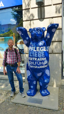 |
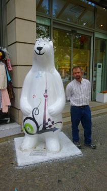 |
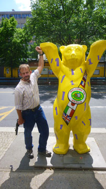 |
The East End of the Unter den Linden
|
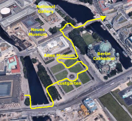
We crossed the Lustgarten, one of Berlin's most popular public spaces, passed by the Berlin Cathedral and a couple of the museums on the island, and then crossed back onto the east bank of the River Speer, turning southeast again to get back to Unter den Linden (which, at Museum Island, angles northeast and becomes Karl-Liebknechtstrasse.
There were lots of neat things to see in this part of our walk (a portion that was not duplicated on our guided tour the next day)- particularly on Museum Island (which we would visit again with Nancy and Prudence).
|
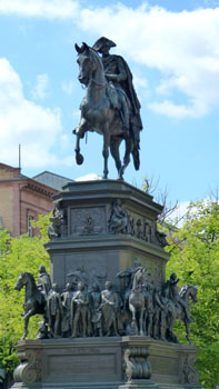
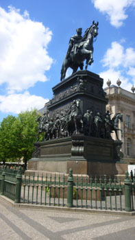
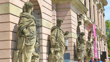
The monument (our two best pictures of which are at right) is 44 ft tall, the mounted statue itself being 19 ft high on an unusually tall pedestal (26 ft) with two bands of sculpture above inscriptions: the middle depicts 74 great men of Frederick the Great's time in life size, many in full relief, and the upper section, reliefs of the king's life, with the four cardinal virtues at the corners. The statue itself depicts Frederick in military uniform and an ermine-trimmed cloak, wearing his decorations, and with his characteristic bicorne hat; he holds the reins in his left hand and in his right has a walking stick.
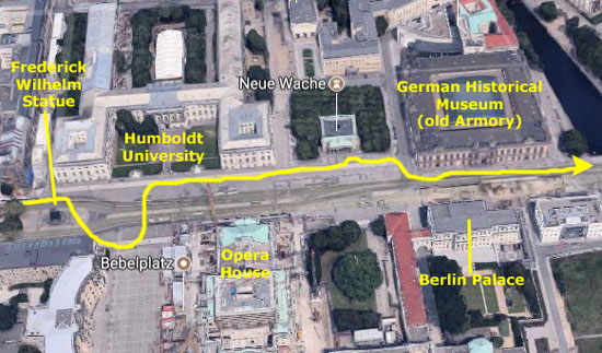
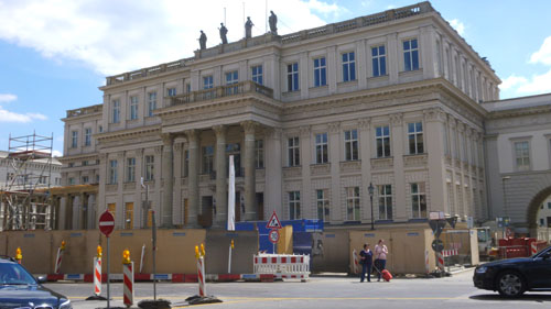
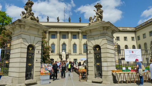
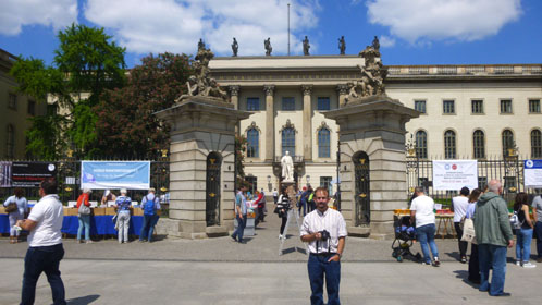
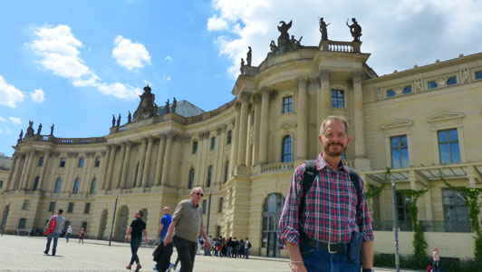
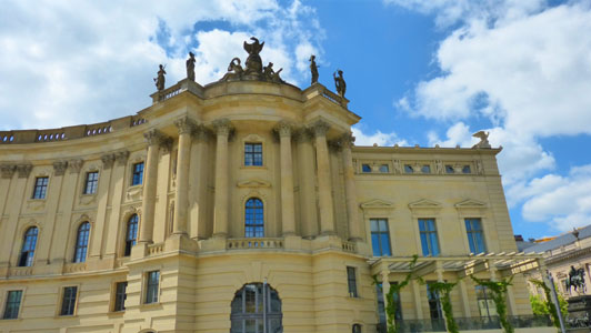
We came next to two interesting sites on either side of the avenue- the main building of Humboldt University on the north and the Bebelplatz on the south. First, let's stop at Humboldt University, an immense neo-classical building- one certainly worth of a constructed panoramic view:
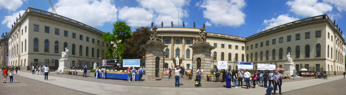
The Humboldt University of Berlin is one of Berlin's oldest, founded in 1811 as the University of Berlin by Frederick William III of Prussia, on the initiative of the liberal Prussian educational reformer and linguist Wilhelm von Humboldt. The Humboldt university model has strongly influenced other European and Western universities. Its main location is here on the avenue Unter den Linden, in the former palace of Prince Henry of Prussia which his brother, King Frederick II, had built for him between 1748 and 1753. In 1949, it took on the Humboldt name, in honor of its organizer, Wilhelm von Humboldt, and his brother, geographer Alexander. The university has been associated with 40 Nobel Prize winners and is considered one of the best universities in Europe as well as one of the most prestigious universities in the world for arts and humanities.
The building and gate columns were adorned with beautiful sculptures, including the statue of Hermann Ludwig Ferdinand von Helmholtz (German physician and physicist, 1821�1894) who made significant contributions in several scientific fields. (You can see that statue inside the courtyard in both of the pictures below:
 |
 |
Across the street from Humboldt University is the Bebelplatz (formerly called the Opernplatz)- a public square. It is bounded to the east by the State Opera building (hence its prewar name), to the west by buildings of Humboldt University, and to the southeast by St. Hedwig's Cathedral, the first Catholic church built in Prussia after the Reformation. The square is named after August Bebel, a founder of the Social Democratic Party of Germany in the 19th century.
 Bebelplatz West Side |
 Humboldt Univesity Law Library |
From the Bebelplatz, Fred took this interesting picture ("I'll take 'Things That Stick Into the Sky' for $200, Alex").
|
The plain building is characterised by four massive corner risalits and a portico of Doric columns, of the original Greek form, without bases. The statuary in the tympanum shows Nike, the goddess of victory, deciding a battle. In 1931 the building was redesigned into a memorial to those who died in World War I; the interior has a bare hall with a central black granite block with an oak wreath situated under an oculus. The Neue Wache was heavily damaged by bombing and artillery during the Battle of Berlin in last months of World War II. From 1957 the Communist authorities had the Neue Wache rebuilt and reopened in 1960 as a "Memorial to the Victims of Fascism and Militarism"- with an eternal flame, the remains of an Unknown Soldier and permanent honor guards. In 1993, the building was again renamed and the central sculpture under the oculus was replaced by an enlarged version of K�the Kollwitz's sculpture Mother with her Dead Son. The piet�-style sculpture is directly placed under the oculus, and so is exposed to the rain, snow and cold of the Berlin climate, symbolizing the suffering of civilians during World War II. The building is surrounded by neatly spaced rows of trees on three sides.
|
The palace was originally built in the 15th century and changed throughout the next few centuries. It bore features of the Baroque style, and its shape was only finalized in the 18th century. It served as a residence to various Electors of Brandenburg and was the principal residence and winter residence of the Hohenzollern Kings of Prussia from 1701 to 1918. After the unification of Germany in 1871, it was also the central residence for the German Emperors. It became a museum following the fall of the German Empire in 1918. The palace was heavily damaged by Allied bombing in World War II. Although it could have been repaired, the palace was demolished in 1950 by the German Democratic Republic authorities, despite criticism. Following the reunification of Germany, it was decided to rebuild the entire exterior of the palace in the original style except for one side. The new building will have the cubature of the former palace and include authentically reconstructed facades on three of the four exterior sides of the building. The interior will be modern and the seat of the Humboldt Forum, a museum for world culture which is a successor museum of the Ancient Prussian Art Chamber, which was also located in the Berlin Palace. The Humboldt Forum has been described as the German equivalent of the British Museum.
|
|
The museum was actually founded in 1987, on the occasion of the 750th anniversary of the founding of Berlin, with an exhibition on Prussia held in the Reichstag building. Originally the Museum was to be located near the Reichstag Building, but the fall of the Berlin Wall led to a change of plans: on the day of reunification (3 October 1990), the Federal Government transferred the collection and premises of the former Museum f�r Deutsche Geschichte (Museum for German History) to the DHM. Thus, the Zeughaus of 1695� the oldest building on Unter den Linden� became the seat of the German Historical Museum.
Museum Island
|
|
|
|
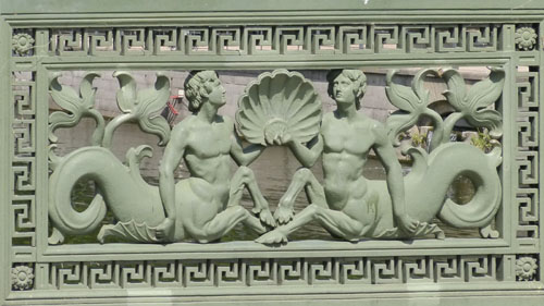
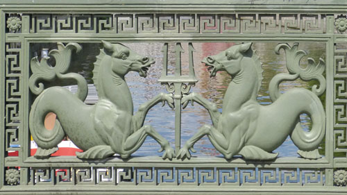
Fred was very interested in the relief panels from which the sides of the bridge were constructed. Here are a couple of them:
|
|
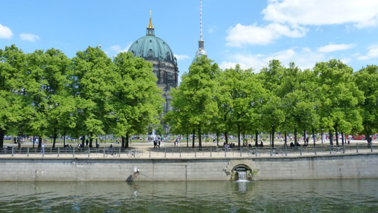
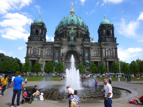
When we got to the Museum Island side of the bridge, we walked north along the canal, and I looked back for a good view of the German History Museum. You can see the line of vendors that I was talking about earlier. We turned and walked out into the middle of the Lustgarten, and right by the central fountain got an excellent view of the Berlin Cathedral.
|
The history of today's church and its community begins in 1451, when Prince-Elector Frederick II Irontooth of Brandenburg moved to what is today the southern part of Museum Island and into the newly erected City Palace, which also housed a Catholic chapel. In 1454, Frederick elevated the chapel to become a parish church, richly endowing it with relics and altars. Pope Nicholas V ordered Stephan Bodecker, then Prince-Bishop of Brandenburg, to consecrate the chapel to Erasmus of Formiae.
The building changed over the centuries, with the current building only a little more than a hundred years old. But the more important change was that the church ceased to be a Catholic Church, becoming first Lutheran and then Calvinist. In the late 1890s, with no separation of the Protestant church and the state of Prussia, Wilhelm II was the head of the church, and so the state paid the complete construction cost of 11.5 million Marks. At 374 ft long, 240 ft wide and 381 ft tall, it was much larger than any of the previous buildings and was considered a Protestant counterweight to St. Peter's Basilica in Vatican City.
We thought that this would be one of the buildings that the other folks would want to tour, so we decided not to go inside ourselves this afternoon. We should have, because as it turned out when we came back intending to go into it, it was temporarily closed to the public as a multi-day religious convocation was occurring on the day we returned. Fred did get a picture of one of the frescoes above the entrance.
|
Please don't be concerned when the movie first starts; why the first few seconds are out-of-focus.
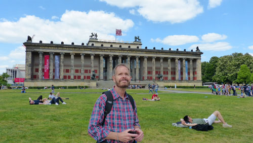
In the movie, the first building you see is the Altes Museum. The Altes Museum (German for 'Old Museum') is one of six museum buildings here on Museum Island. Since the building was completely restored in 2010-11, it has housed the antiquities collection of the Berlin State Museums. The museum building was built in the neoclassical style between 1823 and 1830 by the architect Karl Friedrich Schinkel to house the Prussian royal family's art collection. The historic, protected building counts among the most distinguished neoclassic buildings in the world, and it was of course considered the high point of Schinkel's career. Until 1845, it was called the "Royal Museum". Along with the other museums and historic buildings on Museum Island, the Altes Museum was designated a UNESCO World Heritage Site in 1999. Here are two views- one from the middle of the Lustgarten and the other from a much closer vantage point:
|
|
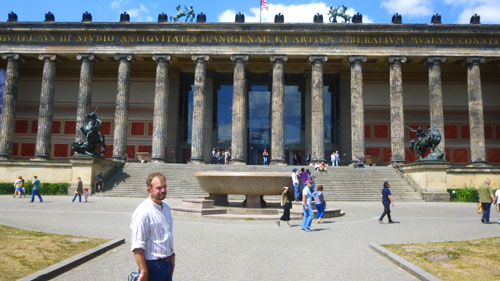
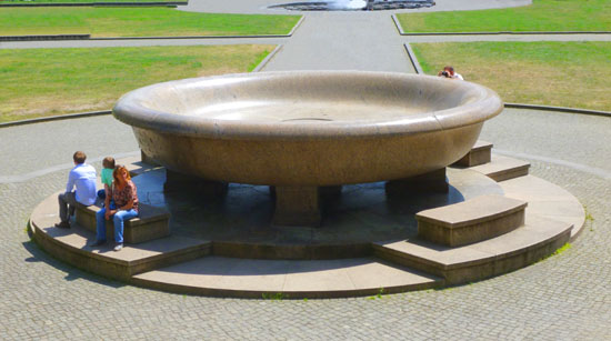
We walked over to the Altes Museum because we could see that there were two large sculptures on either side of the broad steps. When we got there, and part way up the steps, we could see that the large object at the base of the stairs was a huge marble bowl, and its history is immensely interesting.
|
Work to shape the raw boulder began in May, 1827; over 100 skilled workers worked on the initial shaping of the 80-ton piece of rock. But the real problem was how to get the rough shape to Berlin. The rough shape had to be carried from a 500-foot elevation in the Rauensche Hills to the Spree, so a path through the forest had to be cleared, the ground reinforced (with a thick spruce plank) and spruce rollers prepared. (One of these forest paths still remains today.) It took six weeks to reach the Spree where a special barge waited.
But the stone also had to be carried over one bridge into Berlin, but the width between the bridge's side walls was too narrow. So the side walls had to be carefully pared down before the stone could be brought successfully into the city itself. It still took considerable time before the final version of the polished granite bowl found its place in the Lustgarten on November 10th, 1834. (It was originally supposed to be in the rotunda of the Altes Museum- but it didn't fit. That's why today it sits outside the Museum for us to admire!)
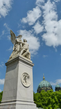
From the staircase, here is a nice view of the bowl and the Berliner Dom, and below are our pictures of the two statues on either side of the staircase:
 |
 |
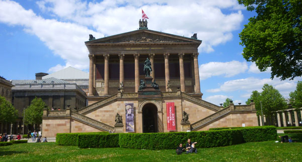
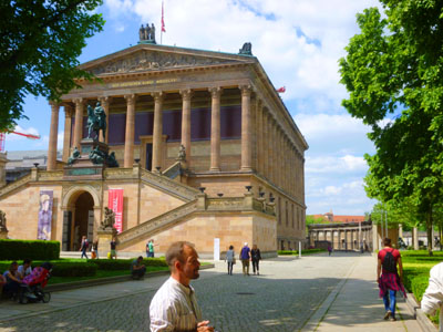
We didn't go into the Altes Museum (or any museum for that matter). We wanted to see as many sites as we could before we had to be back at the hotel to meet the others along about five. We did wander over to the National Gallery, a little further north on Museum Island.
|
|
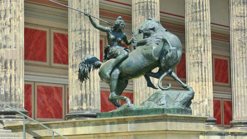
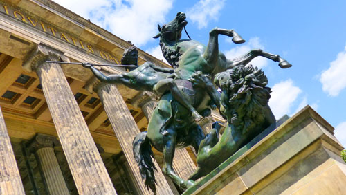
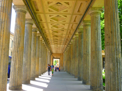
There was a lot to see on the outside of this museum, though. There was a really pretty fountain out in front (but for some reason, photographs of it will have to wait until the day of our tour), and off to the side by the Spree River there was a classic colonnade along the Spree River, and between that row of classic columns there was a sculpture garden, with three or four full size installations- a couple of which you can see at left.
The National Gallery was, I thought, the handsomest building we've seen so far. It was far from the largest (the Reichstag) or the most ornate (Berliner Dom), but with its simple architecture and clean lines, it reminded me of nothing so much as a classic Greek building that could just as easily have been situated on the Acropolis. With another huge colonnade separating it from the street in front, it was simply beautiful.
 |
 |
From the National Gallery sculpture garden, we headed over to the nearby bridge that would take us over to the east side of the Spree. Today was a beautiful day, and there were a huge number of people about.
|
While I was relaxing for a minute, Fred walked over to the other side of the street because he saw a domed building off in the distance and was wondering what it was. We didn't find out until a couple of days hence, on the day of our tour through the National Gallery, the it was the largest synagogue in Berlin- the restored New Synagogue.
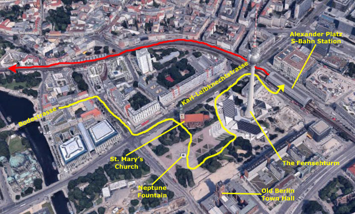
So we headed across the Bodestrasse bridge to the district centered around Alexander Platz.
The Area Around the Alexander Platz
|
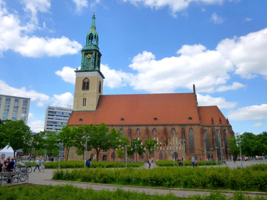
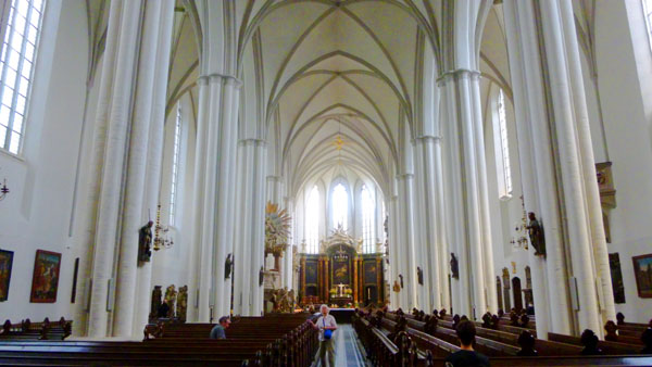
So we walked over to the front of the church to see whether it was open- which it was- and so we went inside. St. Mary's Church, known in German as the Marienkirche is located on Karl-Liebknecht-Strasse (formerly Kaiser-Wilhelm-Strasse) near Alexanderplatz. The exact age of the original church site and structure is not precisely known, but it was first mentioned in German chronicles in 1292. It is presumed to date from earlier in the 13th century. The architecture of the building is now largely composed of comparatively modern restoration work which took place in the late 19th century and in the post-war period. The church was originally a Roman Catholic church, but has been a Lutheran Protestant church since the Protestant Reformation and a united protestant church since the Prussian Union of churches in 1817.
In the interests of your knowing a bit about the church before we head inside, let me first include a picture of the church itself, one that we actually did not take until after we'd been inside. (I also took a picture of just the front of the church and its tower, and you can see that picture here.
|
Along with the Nikolaikirche, the Marienkirche is the oldest church in Berlin. The oldest parts of the church are made from granite, but most of it is built of brick, giving it its characteristic bright red appearance. This was deliberately copied in the construction of the nearby Berlin City Hall, the Rotes Rathaus. During World War II, the church was heavily damaged by Allied bombs. After the war the church was in East Berlin, and in the 1950s it was restored by the East German authorities.
Before World War II, the Marienkirche was in the middle of a densely populated part of the district of Mitte, and was in regular use as a parish church. After the war, this area was cleared of ruined buildings and today the church stands in the open spaces around the Alexanderplatz, and is overshadowed by the East Berlin television tower, the Fernsehturm.
As soon as we got inside the church, I was struck by the difference between this house of worship and the Catholic churches that Fred and I have seen on previous trips- particularly those in Italy and Spain. (I would think back to this church as well when we visited our first Catholic church in Prague, noting how much more opulent the Catholic churches were.) The difference, of course, is that this is a Protestant church, and one of the reasons the Protestants arose was a reaction to what they saw as the excessive luxury of the princes of the Catholic church, and the edifices that they caused to be constructed.
|
First of all, the pulpit was a focal point, and seemed to me to be very ornate (especially compared to those in Protestant churches here, which are often not much more than glorified lecterns). This one had a spiral staircase going up into it (a common feature in many European churches, I would come to realize), and there was lots of statuary and ornaments down at the base of the column supporting the pulpit. But up above the pulpit itself, the canopy covering it was very complex- something like a glorified crown. It's hard to describe, but you can see it in the photo.
The design of this church was familiar to me; it consisted of a nave with an aisle on either side- certainly a traditional arrangement. The difference with other churches we've seen in the past, as well as almost every church we will see in Prague, was that there is no transcept, or cross-aisle, towards the front of the nave ahead of the sanctuary.
|
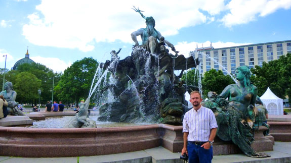
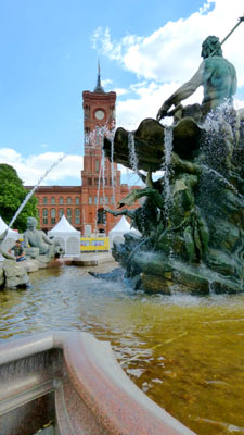
After we left the church, we were able to head outside to the southeast and get the pictures we wanted of the building itself (the ones you saw above). Then we went over the large, ornate fountain nearby.
|
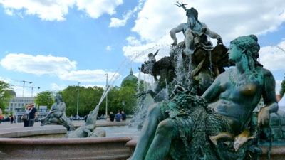
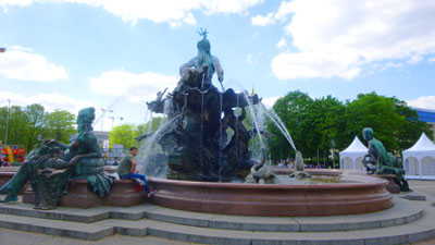
The fountain was removed from its original location at the Schlossplatz in 1951, when the former Berliner Stadtschloss (Berlin City Palace) there was demolished. Eventually, after being restored, the fountain was moved in 1969 to its present location between the St Mary's Church and the Rotes Rathaus (old Berlin Town Hall).
The fountain has a diameter of 60 feet, and is about 35 feet high. (There was another well-known Neptunbrunnen in Breslau (nicknamed "Gabelj�rge" or "Georgie Fork" by the locals), but it was destroyed during World War II.)
|
|
|
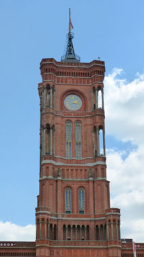
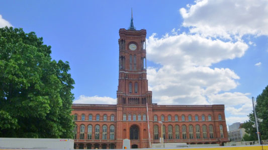
From the fountain, we tried to get a bit closer to the old town hall nearby; there was construction going on, and barriers kept us from getting too close. The Rotes Rathaus (German: Red City Hall) is the town hall of Berlin, home to the governing mayor and the government (the Senate of Berlin) of the Federal state of Berlin. The name of the landmark building dates from the facade design with red clinker bricks.
|
|
The building was heavily damaged by Allied bombing in World War II and rebuilt to the original plans between 1951 and 1956. The Neues Stadthaus, which survived the bombing and had formerly been the head office of Berlin's municipal fire insurance Feuersoziet�t in Parochialstrasse served as the temporary city hall for the post-war city government for all the sectors of Berlin until September 1948. Following that time, it housed only those of the Soviet sector.
The reconstructed Rotes Rathaus, then located in the Soviet sector, served as the town hall of East Berlin, while the Rathaus Sch�neberg was the town hall of West Berlin. After German reunification, the administration of reunified Berlin officially moved into the Rotes Rathaus on 1 October 1991.
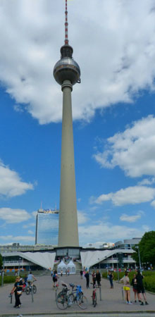
Now we walked to the east side of the plaza to have a look at the Fernsehturm (English: TV Tower). We could easily see that if we got much closer to the tower, we would not be able to get it all in one picture, so from a point by the fountain Fred took a good picture of all of it. I waited until we got to the bottom of the stairs, where I took two pictures and stitched them together. These pictures are below, with my closeup being in a scrollable window:
|
|
We knew you can go up in the tower; the visitor platform is 670 feet up, and on a clear day you can see 25 miles. You can take an elevator to the platform and to the revolving restaurant above it or, if you feel energetic, you can climb 986 steps.
In 1964, Walter Ulbricht, leader of the Socialist Unity Party which governed East Germany was looking to build a symbol for East Germany (also wishing to incorporate a reference to Sputnik). The Tower was deliberately constructed in the center of the historic medieval center of Berlin, resulting in the destruction of a huge portion of the historic center of the capital of Germany. A medieval church stands next to the tower as a testament to the destruction of the old city. Despite its dark history, it is among the best known sights in Berlin, and hosts around a million visitors a year.
Although we, ourselves, did not get a good picture of it, when the sun shines on the Fernsehturm's tiled stainless steel dome, the reflection usually appears in the form of a cross. Berliners nicknamed the luminous cross Rache des Papstes, or the "Pope's Revenge". For the same reasons, the structure was also called "St. Walter" (from Walter Ulbricht).
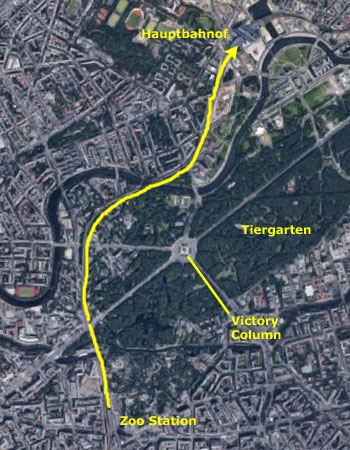
From here, we headed around the northwest side of the TV Tower, getting another nice picture of St. Mary's Church before we got around northeast of the tower to find the Alexanderplatz S-Bahn station. There, we hopped on the next train heading west towards our hotel so we could visit the Tiergarten.
The Tiergarten and the Victory Column
|
The beginnings of the Tiergarten can be traced back to 1527. It was founded as a hunting area for the Elector of Brandenburg, and was situated to the west of the town of Old Berlin. In 1530 the expansion began; acres of land were purchased and the garden began to expand towards the north and west. The total area extended beyond the current Tiergarten, and the forests were perfect for hunting deer and other wild animals. The Elector of Brandenburg had wild animals placed within the Tiergarten, which was fenced off from the outside to prevent the creatures from escaping, and was the main hunting ground for the electors of Brandenburg. This hobby, however, began to fade away as the city of Berlin began to expand and the hunting area shrank to accommodate the growth.
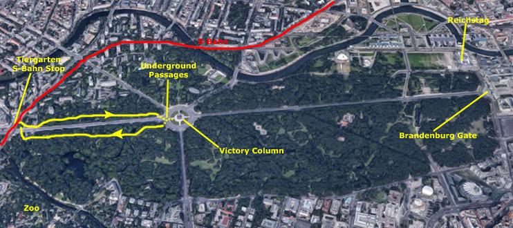
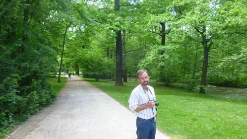
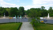
We can talk more about the evolution of the modern park, but for now, Fred and I got off the train at the Tiergarten Station and then headed towards the Victory Column. We could have simply walked on the sidewalk along the Bundestrasse, but we thought it would be nicer to go via one of the park's paths about 50 feet into the park on the north side of the avenue. The trees and the scenery were pretty neat; many of the trees had markers on them as to what they were.
 |
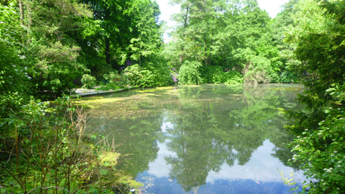 |
Walking through the park we saw numerous improved paths heading off north and northwest, and a number of rougher paths as well. There were two or three small ponds like the one above as well, and we could see some statuary also.
|
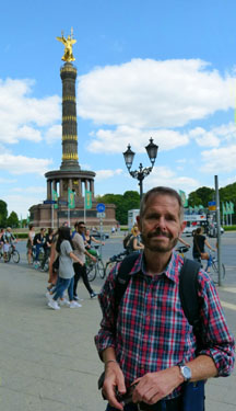
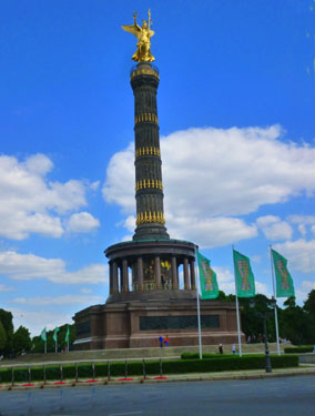
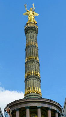
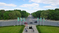
The Victory Column is a monument designed in 1864 by Heinrich Strack to commemorate the Prussian victory in the Danish-Prussian War. By the time the column was inaugurated in 1873, Prussia had also defeated Austria and its German allies in the Austro-Prussian War (1866) and France in the Franco-Prussian War (1870�71), giving the statue a new purpose.
In a change to the original plans, these later victories in the so-called "unification wars" inspired the addition of the bronze sculpture of Victoria- 27 feet high and weighing 35 tons- designed by Friedrich Drake. Berliners have given the statue the nickname "Goldelse", meaning something like "Golden Lizzy".
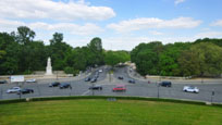
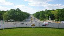
The Victory Column is one of Berlin's major tourist attractions, which is one reason why we wanted to come see it. Another reason was that we read that you can buy a ticket to climb to the top where there are supposed to be expansive views of the entire city. The question was, "How do we get to the monument?". We could see people out on it, but we didn't see any crosswalks across the traffice circle. That's when I noticed that on this corner there was a little structure that I thought was a park building but which actually gave access to a tunnel running under the avenue to the opposite corner. A little map disclosed that halfway under the avenue, the passage had a T-intersection and we would find a tunnel leading to the center of the circle to give access to the monument. As it turned out there was an identical tunnel on the opposite side of the monument, again connecting the center of the circle to the two corners of the Bundestrasse.
|
On 18 January, 1871, in the Hall of Mirrors in the Palace of Versailles, the Prussian King Wilhelm I was proclaimed German Emperor by the German Princes. This had been preceeded by the later so-called "Unification Wars", three wars with Prussia, in various alliances, had all won gloriously. As a result of its military success, twenty-two up-until-then sovereign German states (excluding Austria) and three free hanseatic cities merged together to form the first German national state- the German Empire.
The Victory Column of Berlin, its purpose to glorify most recent history, was the first nationalmonument erected in the newly-founded empire in its new capital city and sparked off a number of other monument initiatives.
Its style is a perfect example of the empire's feeling for architecture (the Grunderjahre period). The statue of Victory is a late conclusion of the 19th century drafts of Schinkel and Rauch.
This unique memorial column, with its unusual proportions and sheer size, was designed to compete with the other similar memorials of high aspiration in Europe's capital cities, such as the Colonne Vendome in Paris or London's Nelson Column.
The Victory Column was solemnly inaugurated in 1872, the date of the third anniversary commemorating the victorious "Battle of Sedan" against the French. The inauguration took place at what is today iknown as the Platz der Republik. The column was designed by Johann Strack (1805-1880), who, constantly being surpassed by new events, had been working on its sketches since 1864.
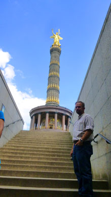
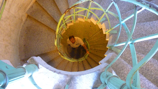
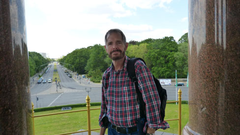
I was anxious to go up in the column, so we paid our modest entry fee and began our climb up the spiral staircase- 285 steps up to the platform.
 |
 |
When we got to the top and had a chance to look out, we found that the views indeed were pretty neat; we got to see some views of places we'd been earlier in the afternoon- and from an entirely different perspective. Of course, we were anxious to look towards the Brandenburg Gate and beyond since that's where we had just been. Here are two pictures looking in that direction- my normal view and Fred's closeup:
 |
 |
Fred's closeup is pretty interesting, as you can clearly see most of the places we stopped earlier. At the center, of course, is the Brandenburg Gate, with Unter den Linden beyond. You can see the red brick tower of the old Berlin Town Hall near the Neptune Fountain, and if you move left from there you can see the three domes of the Berliner Dom. To the left of that, the TV Tower stands out, but if you look down towards its base you can see the steeple of St. Mary's Church. Finally, the light-colored building at the very left just above the forest is the south wing of the Reichstag.
In addition to the pictures looking out over the city, I took a few looking down the side of the Column to the ground. As I've mentioned before, I have developed a bit of a phobia about leaning out from structures and looking down, but these two pictures turned out well:
 |
 |
The golden statue atop the column was made of fire-gilded bronze by the sculptor Fredrich Drake (1805-1882). The Victoria, her wings outstretched, with the military ensign and the Iron Cross, is holding up the laurel wreath in her right hand. She is wearing a Prussian eagle helmet upon her head, giving her th eappearance of Borussia- the personification of Prussia. When you look at that picture, note the golden railing around the observation platform, and compare it to the picture above looking down the side of the column.
We took so many pictures from up here that I had to winnow them down. Some I stitched together into a panorama that you'll see in a moment, and many were duplicates. Others were just nice cityscapes but not otherwise interesting. Here are the remaining views that I think are worth your time to have a look at:
 |
| Looking West Along the Bundestrasse Towards the Tiergarten S-Bahn | The Bismarck Memorial (moved here from the Reichstag) | Looking Over the Zoo to the Kaiser Wilhelm Church | The New Chancellery Building Beside the River Spree | Helmuth von Moltke/ Circular Government Office/ Bellevue Palace |
A Path Through the Tiergarten to the Southwest | Looking East Along the Budestrasse Towards the Brandenburg Gate |
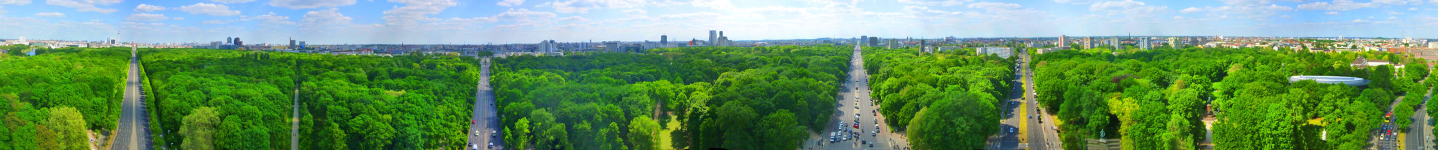
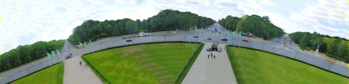
In addition to the pictures above, I thought I would take this opportunity to try to put together a 360° of Berlin from the Victory Column. Creating these mega-panoramas has to be done manually; one can never hold the camera at the same level and angle while turning completely around, nor can one walk entirely around a platform like this one, as the camera won't go that long. So the only solution is to take a series of pictures and stitch them together. This isn't easy; the camera has to be held at the same level and angle for each picture, and care must be taken to sufficiently overlap them yet minimize the number of pictures involved- in this case, eleven of them. The light at different angles causes problems, too. Things worked out here (they don't always) and I ended up with a pretty decent panorama. It is in the scrollable window below. All the way to the left is the Bundestrasse (looking east) followed, to the right, by the Hofjageralle to the south, the Budestrasse (looking west), the Altonaerstrasse to the northwest, and finally the Spreeweg to the northeast.
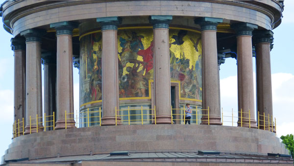
As advertised, the views (as you can see) were pretty incredible. We headed back down the stairs and went outside and walked around the circular colonnade at the top of the column's pedestal. Here are a couple of pictures we took in the colonnade itself:
 |
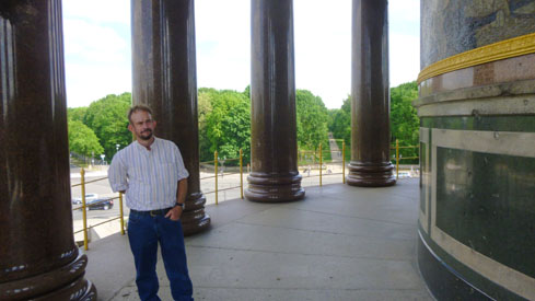 |
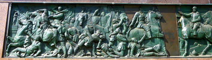
We're going to take a look at the inner wall of the colonnade that is open to the outside. But you might want to see what the colonnade looks like as a whole. Fred took the picture below, left, a little earlier in our visit to the Victory Column.
|
Over the door, Germania, the "Guard of the Rhine", keeps a lookout towards the west. A crowned Prussian eagle and a Gallic eagle wearing the Tricolor symbolize an impending war, with the biggest danger being exuded from the personification of the French. Both are floating on a cloud which brings the scourges of mankind: war, hunger and disease. Soldiers from the four kingdoms of Saxony, Bavaria, Prussia and Wurttemberg unite for the battle, under the waving black-white-red flag of the German Empire. The scene in the middle, in which the Prussian and Bavarian military leaders, mounted on horseback, shaking hands on the battlefield, symbolizes the fraternization between northern and southern Germany. The battle can only end with a victory. On the steps of the throne an allegory- "loco imperatoris"- in lieu of the emperor- Wilhelm I, receives the medieval imperial crown being handed over by a Bavarian herald. Surrounded by ravens, King Barbarossa, still slumbering in Kyffhauser, awakes and draws his sword. The figures who hand the weapons to Germania emerge- a seemingly endless circle. The mosaic went all around the wall, and we took pictures of other sections as well. Here are some of those pictures:
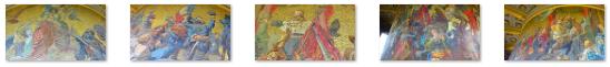 (Click on Thumbnails to View) |
From the colonnade, we got some other good pictures, including a better view of the Bismarck Memorial, dedicated to Prince Otto von Bismarck, Minister President of the Kingdom of Prussia and the first Chancellor of the German Empire. It was sculpted by Reinhold Begas. The statue, along with the famous Berlin victory column, were once located in front of the Reichstag building before they were moved in 1938 by Adolf Hitler. Good that they were, for the old garden in front of the Reichstag was completely obliterated in the war.
|
The last pictures we took from the Victory Column were again taken at the level of the mosaics, and they looked in various directions from the column at the avenues radiating out, and of the traffic circle around it. Here is what a few of these looked like:
 |
 |
 |
 |
I thought I might try my hand at creating a panorama, and for that I would have to connect these photographs with pictures that connect them, which I did. But when I went to stitch them together, I found it to be impossible, as each picture has an arc of the traffic circle, and these arcs wouldn't connect. But then I thought that they would connect if the pictures could be rotated so the individual arcs could become larger, continuous arcs. I tried this approach, and it worked- at least for a time, for perhaps a quarter of the way around the column. So consider the result below a photographic experiment- a way to simulate a fish-eye lens with a $50 point-and-shoot snapshot camera:
We both thought our visit to the Victory Column well worth our time, but it was getting on towards 5PM, and the arrival of the rest of our friends, so we left the column and headed back to the Tiergarten S-Bahn station, again walking through the park but this time on the south side of the Bundestrasse. From there, we walked back to our new hotel around the corner from the Wyndham- the Hotel Am Steinplatz.
An Evening Excursion with Prudence, Nancy, Ron, and Karl
|
Nancy had picked this hotel; she has a fondness for off-chain, boutique hotels. The hotel was certainly very, very nice (although the Wyndham Excelsior wasn't too shabby either). The courtyard was certainly a pleasant place to relax, and we did so just about every afternoon. But more about that later.
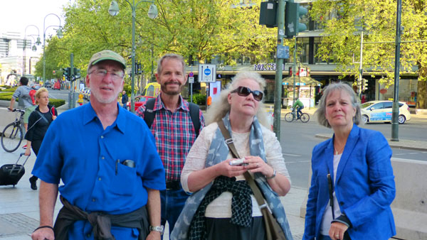
We sat with them for a while and then suggested that we use the early evening to familiarize them with the Berlin transport system by taking a ride back to the Hauptbahnhof to show them that area, and then return to the Zoo station to walk around that area for a while before going to have dinner.
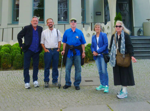
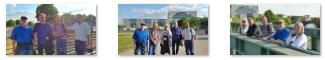
That was agreeable so we started out, pausing in front of the hotel for our first group picture.
A Return to the Hauptbahnhof
|
At the bahnhof, Fred and I took the group to the ticket machines to explain how they worked. I thought there might be times when we would not all be together, and so everyone should know how to operate them. This was, as it turned out, incorrect, as I don't think that any of our group used the S-Bahn or U-Bahn without Fred and I being along. We also had to make sure that everyone knew that the purchased tickets had to be validated in one of the little machines scattered around just before one's first trip using it.
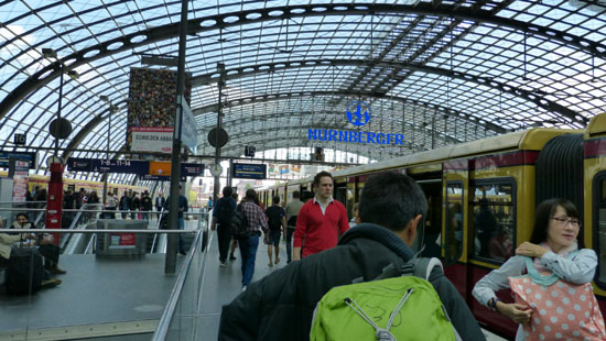
While we were waiting for our train, I gave the group a short explanation of the part of the route system we'd probably be using- again so that everyone could travel independently if they wished. We got on one of the trains heading towards the Hauptbahnhof, and that's where Fred took this picture of Nancy, Ron, and Prudence on the train. We arrived a few minutes later on the Hauptbahnhof platform and Fred and I led the group downstairs into the station proper.
|
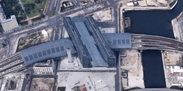
The building of this amazing station began with tunnel work in 1995, and ended with the completion of the station itself in 2006, and the ceremonial opening of the station in May of that year. There are four tunnel tubes for long-distance and regional services on the lowest level, and two tubes in a separate alignment, one level up, for the U-Bahn; there is also a separate road tunnel ventilated by a 200 ft tower. During The construction of these tunnels, the course of the Spree had to be diverted; even so, a year was lost dealing with water leaks. The S-Bahn routes enter and leave the station on the highest two levels on curved, 1500-foot bridges that span more than entire length of the station; you can see the underside of the lower level of these bridges in some of our movies and photos.
The main station hall is spanned by a similarly curved glass roof with a surface area of some 120,000 square feet; a photovoltaic system (solar panels) is integrated into the glass surface. The main concourse, supported by two towers, provides roughly 450,000 square feet of commercial space. The new station was officially named "Berlin Hauptbahnhof" on its opening. Four other large stations serve Berlin; these are located on the edges of Berlin at the compass points.
We went down a level or two so everyone could see clearly the extent of this huge station, and while everyone was looking around, Fred and I each made movies that you may find illuminating:
|
|
At the River Spree
|
(Click on Thumbnails to View) |
Tomorrow our walking tour of Berlin will begin at the Reichstag, so we were able to point out that landmark to the other folks, and with our trip back to the Zoo Bahnhof we had gotten them acclimatized to the transport system.
The Breitscheid Platz near the Zoo Bahnhof
|
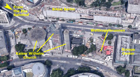
There were a number of interesting things to see, including the Kaiser Wilhelm Church, the huge fountain known as the Weltkugelbrunnen, the large enclosed Europa Center, and another shopping complex across the street to the north- Bikini Berlin.
We had some time with the group this evening- not enough to go to a museum or other tourist spot (even if they had still be open), or to get over to the former East Berlin to see things there- and so before we all returned to the hotel and some dinner, we thought this would be a good place to walk around and see a few things.
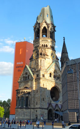
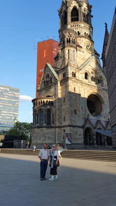
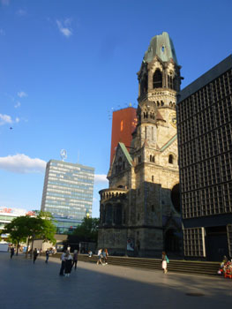
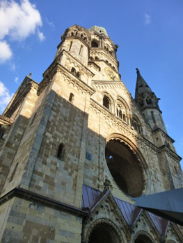
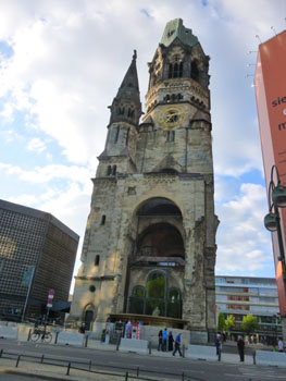
Kaiser Wilhelm Memorial Church
|
|
The construction of the original church was part of a Protestant church-building program initiated by Kaiser Wilhelm II and his consort Augusta Victoria to counter the German labor movement and socialist movement by a return to traditional religious values; he would name the church in honor of his grandfather, Kaiser Wilhelm I. The design competition winner called for a large church to be built in a Neo-Romanesque style, with huge wall mosaics, a 370-ft spire, and a nave seating 2,000 people.
The foundation stone was laid in 1891 and the church was dedicated in 1895, although portions were not completed for another ten years. The church cost 6.8 million gold marks (about $20 million today) and the funds were obtained primarily through donations. On the night of 23 November 1943, the church was extensively damaged in an air raid, although by no means beyond repair. A remnant of the spire and much of the entrance hall survived intact, as did the altar and the baptistry.
After the war, in 1947, the church foundation decided to rebuild the church, but the manner in which this should be done was contentiously debated until the late 1950s. The winner of the 1956 design competition initially proposed that the remnant of the old spire to be torn down, but that plan provoked a public outcry in which the ruined tower was characterized as the "heart of Berlin". The design was revised to preserve the tower, while most of the remaining structure was pulled down in order to build the modern church that now occupies most of the site. So now there are three major buildings- the new church and new belfry with the old, partially destroyed spire between them.
|
|
|
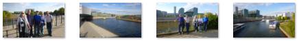
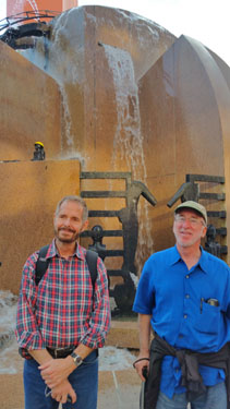
The ground floor of that spire has become a museum and memorial hall, nicknamed by Berliners "der hohle Zahn", meaning "the hollow tooth" (which it actually resembles). Prudence got a really neat picture looking through the spire to the belfry, and she also got a nice picture of Fred and Nancy and an interesting sculpture.
On the steps just north of the new church building (the westernmost in the aerial view above) I found what turned out to be a touching memorial to the twelve Germans who were killed and the 48 who were injured when a truck was intentionally driven into the crowds at the Chrismas Market last December. The memorial was started on the six-month anniversary of the tragedy, and for four days now, candles have been accumulating. The sign says simply "Why?".
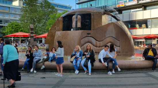
From the church, we wanted to take the group across the plaza to look at the Weltkugelbrunnen.
The Weltkugelbrunnen
|
The fountain was designed and created by Joachim Schmettau and his collaborator, the sculptor Susanne Wehland, and is the largest fountain in the district of Charlottenburg-Wilmersdorf.
The center is a large hemisphere with bubbling water and arc jets plus a Noah's Ark in a semicircular basin that faces the Kaiser Wilhelm Memorial Church. Water flows towards the Europa Center down a curved cascade of steps into a basin below. This modern fountain is decorated with various figures, some humorous, some giving pause for thought. These include two lovers, a crocodile, two small malicious animals, a bathing lady with a helmet that was once gold and a bottle by her side, a character called Vanity and another called Harry the Welder, who of course is wearing goggles. And on the steps stand the Watchmen.
The movie I made this evening was better than last night, I think, so it and the other picture I took of the fountain are below:
|
|
The official name of this protected monument, World Globe Fountain, did not appeal to Berliners. Instead, it is affectionately known as the "Wasserklops" ("Water Meatball") and is a popular meeting place in front of the Europa Center. Fred and I didn't take many more pictures this evening, but Prudence got some interesting ones of the fountain, different from those we got last night (and better, I think, because she had more light). Here are some of them:
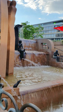 |
 |
 |
 |
The operation of the Weltkugelbrunnen costs the district of Charlottenburg-Wilmersdorf around 75,000 euros per year. This is a high cost for the district, so the Weltkugelbrunnen is dependent largely on individual and corporate sponsors.
Some Final Pictures from the Breitscheid Platz
|
|
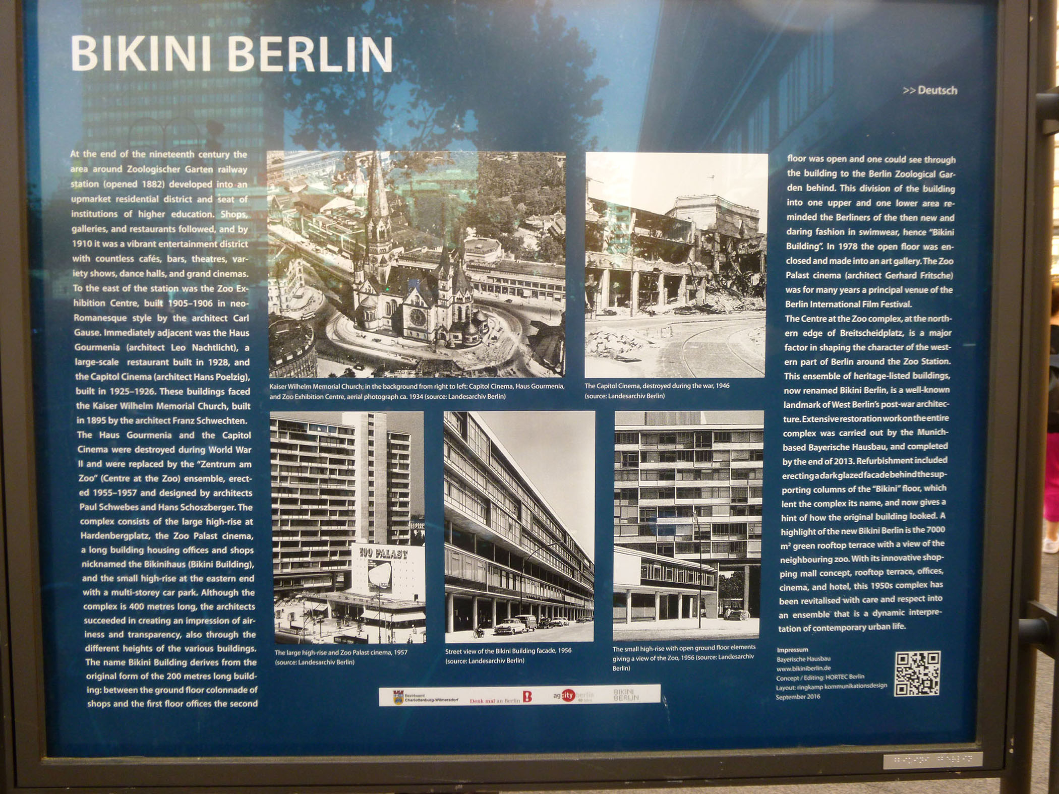
One final thing- while everyone was looking at the church, I crossed the street to the north because I saw a display sign and wanted to check it out. It was in front of a building that is known as Bikini Berlin, and I wanted very much to find out how the building or the area got that title. I found the display very interesting, and so I want to give you a chance to read it and look at its pictures. I have put an image of the entire sign in the scrollable window below, so you can scroll back and forth and read and see all of it.
We headed back to the Hotel Am Steinplatz and ended up having a delicious dinner at a German restaurant that we walked to from the hotel.
You can use the links below to continue to another photo album page.
|
May 22, 2017: A Guided Tour of East and West Berlin |
|
May 20, 2017: An Evening in Berlin |
|
Return to the Index for Our Visit to Berlin |