|
May 23, 2017: A Day on Museum Island |
|
May 21, 2017: A Walking Tour of Berlin |
|
Return to the Index for Our Visit to Berlin |
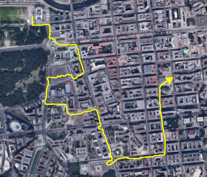
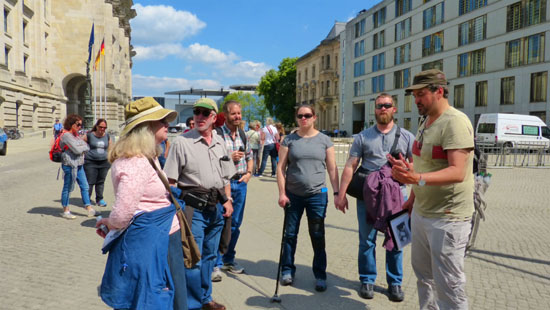
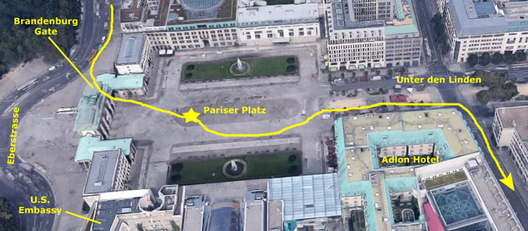
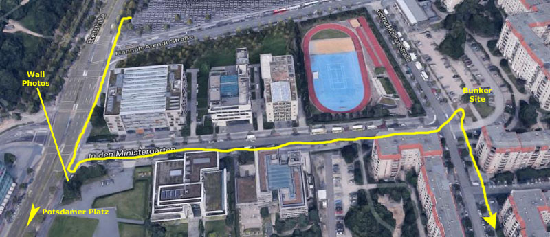
Today, Karl has booked us all on a six-hour guided tour of many of Berlin's most important sites- from the Reichstag, where our tour began, to Checkpoint Charlie, to the Gendarmenmarkt, close to where it ended.
|
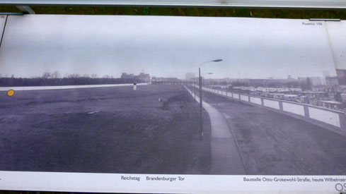
I thought it would be confusing to add in the approximate route of the old Berlin Wall, but generally it ran north-south through this area, passing just to the east of the Reichstag in the upper left of the view, right through the Brandenburg Gate and then generall south and east; we stopped at one section of the wall where it was running almost directly west to east. Looking back on it, it turned out that most of the tour (about 75% of it) took us through areas that were formerly part of East Berlin.
The route of the tour covered between three and four miles, but it was done at a leisurely pace (too leisurely for my taste) but the walking was broken up by the stops we made (including one for a bit of lunch) at which time our guide (whose name I have forgotten, but who I remember was not from Berlin but from somewhere else in central Europe) would describe what we were seeing or tell us a story or something similar. I was not always walking within earshot of him, but I understand that he did quite a bit of talking, too, as we were walking along. He was very knowledgeable and able to answer almost all the questions we asked. He came prepared with a folder of old photographs and other material to add to his mini-lectures.
On our tour we saw some major tourist sites (as well as a number of lesser sites our guide knew about and which were just as interesting). Among them were the Reichstag and the Brandenburg Gate- two places that Fred and I visited yesterday on our own. Then we walked to the Memorial to the Murdered Jews of Europe, Potsdamer Platz, Hitler's Bunker, the Berlin Wall (and Checkpoint Charlie) and the Gendarmenmarkt. The tour ended at a chocolate shop and restaurant were we were able to get off our feet for a while.
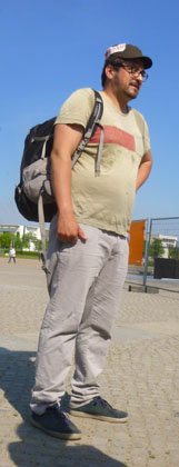
The tour was an intimate one; in addition to the six of us, there was one other couple and another single person, so there were only about ten of us- few enough that we were all able to get individual questions answered and feel that we had gotten personal attention from our guide.
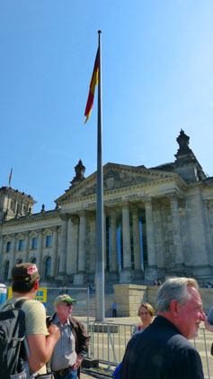
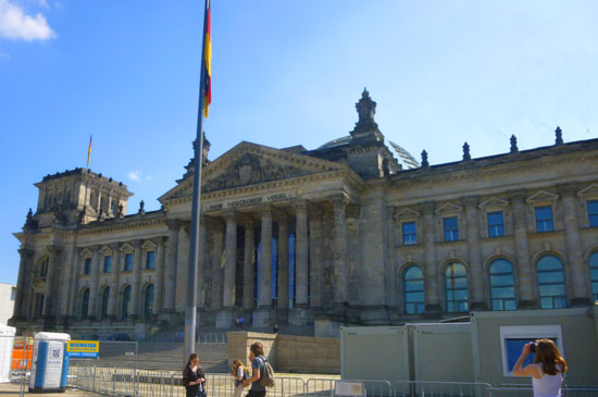
Our Tour Begins at the Reichstag
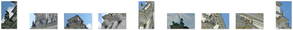
The Reichstag
|
The ruined building was made safe against the elements and partially refurbished in the 1960s, but no attempt at full restoration was made until after German reunification in 1990, when it underwent a reconstruction led by architect Norman Foster. After its completion in 1999, it once again became the meeting place of the German parliament: the modern Bundestag. (The building is still referred to as the Reichstag; the body that meets inside the Bundestag.) The modern building just north of the Reichstag building, the one that actually spans the River Spree, is something like our House and Senate office buildings, as there is not enough space in the Reichstag building itself.
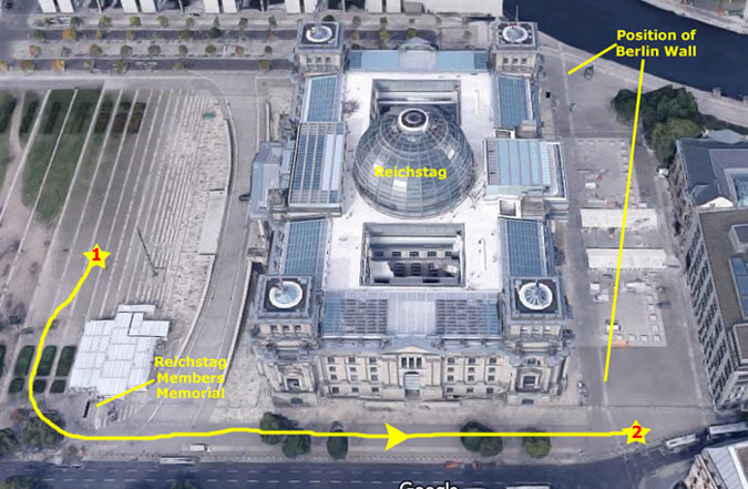
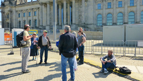
We met our guide in front of the building. On the aerial view, the broad steps on the west side of the building are entirely open but, a you will see in our photographs, they were preparing for some sort of event. A portable stage had been constructed, and much of the front of the building was blocked off.
|
|
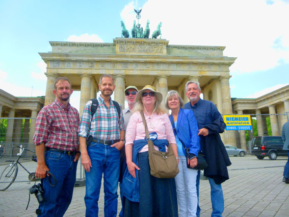
I should of had the group pose before we started out, and I probably would have, if the front of the Reichstag had been more photogenic. But there were so many barriers around and so much clutter, that I guess I just didn't think of it.
|
The term Reichstag, when used to connote a diet, dates back to the Holy Roman Empire. The building was built for the Diet of the German Empire, which was succeeded by the Reichstag of the Weimar Republic. The latter would become the Reichstag of Nazi Germany, which left the building (and ceased to act as a parliament) after the 1933 fire and never returned; the term Reichstag has not been used by German parliaments since World War II. In today's usage, the word Reichstag (Imperial Diet Building) refers mainly to the building, while Bundestag (Federal Diet) refers to the institution.
Construction of the building began well after the unification of Germany in 1871. Previously, the parliament had assembled in several other buildings in Leipziger Strasse in Berlin but these were generally considered too small, so in 1872 an architectural contest was held for the design and construction of a new building on the site of a palace owned by a Polish-Prussian aristocrat on the east side of the K—nigsplatz (today, Platz der Republik). Wilhelm I, Otto von Bismarck and the members of the Bundestag argued about the construction, and the negotiations to acquire the site were lengthy. Consequently, another contest was held in 1882, and the winner was a Neo-Baroque design (which was actually based on Philadelphia's Memorial Hall, the main building of the 1876 Centennial Exhibition.
The foundation stone was finally laid by Wilhelm I in 1884, and construction was completed ten years later under Wilhelm II. The original building was acclaimed for the construction of an original cupola of steel and glass (not the current glass dome), considered an engineering feat at the time. But its mixture of architectural styles drew widespread criticism. In 1916 the iconic words Dem Deutschen Volke ("[To] the German people") were placed above the main faÓade of the building, much to the displeasure of Wilhelm II, a budding authoritarian, who had tried to block the adding of the inscription for its democratic significance. After World War I had ended and Wilhelm II had abdicated, Philipp Scheidemann proclaimed the institution of a republic from one of the balconies of the Reichstag building. The building continued to be the seat of the parliament of the Weimar Republic (19191933), and was still called the Reichstag.
|
The building burned in 1933, under suspicious circumstances. This gave a pretext for the Nazis to suspend most rights provided for by the 1919 Weimar Constitution in the Reichstag Fire Decree, allowing them to arrest Communists and increase police action throughout Germany.
During the 12 years of Nazi rule, the Reichstag building was not used for parliamentary sessions. Instead, the few times that the Reichstag convened at all, it did so in the Kroll Opera House, opposite the Reichstag building. This applied particularly to the session of 23 March 1933, in which the Reichstag surrendered its powers to Adolf Hitler in the Enabling Act. The building fell into disuse.
The building was further damaged by air raids. During the Battle of Berlin in 1945, it became one of the central targets for the Red Army to capture, due to its perceived symbolic significance. Today, visitors to the building can still see Soviet graffiti on smoky walls inside as well as on part of the roof, which was preserved during the reconstructions after reunification.
Reichstag Members Memorial
|
|
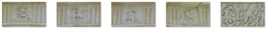
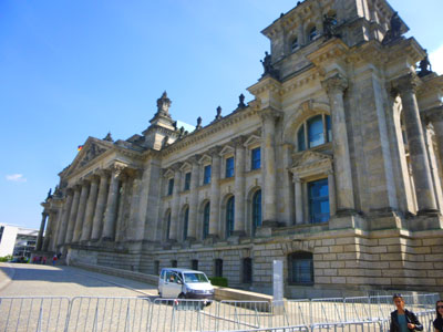
We continued walking along the south side of the building to reach its southeast corner (stop #2 on the aerial view above). Along the way, we passed some of the most ornate lampposts I've seen, and took a number of pictures of the architectural details of this beautiful building; here are some of those pictures:
 (Click on Thumbnails to View) |
Introduction to the Berlin Wall
|
Another architectural contest was held, and the building was reconstructed the building from 1961 to 1964. All the sumptuous heraldic statues, monuments, decorations, and the like that harked back to the mythology of the German past were removed from the inside, as well as the largest ones outside. and also the largest ones on the outside of the building. In effect, he created a plain building inside the historic Reichstag, retaining only the outer walls stripped of most of their statues and decoration. The artistic and practical value of this work was the subject of much debate after German reunification. Under the 1971 Four Power Agreement on Berlin, the West German parliament, the Bundestag, was not allowed to assemble formally in West Berlin, so the building was used only for occasional representative meetings, and other events.
The official German reunification ceremony on 3 October 1990, was held at the Reichstag building and one day later, the parliament of the united Germany would assemble in an act of symbolism in the Reichstag building. On 20 June, 1991, the Bundestag voted and, by a slim majority, decided that both government and parliament would return to Berlin from Bonn. So another reconstruction began. During that reconstruction, the building was first almost completely gutted, taking out everything except the outer walls, including all changes made in the 1960s. Respect for the historic aspects of the building was one of the conditions stipulated to the architects, so traces of historical events were to be retained in a visible state. Among them were graffiti left by Soviet soldiers after the final battle for Berlin in AprilMay 1945. Written in Cyrillic script, they include such slogans as "Hitler kaputt" and names of individual soldiers. However, graffiti with racist or sexist themes was removed. The reconstruction was completed in 1999, with the Bundestag convening there officially for the first time on 19 April of that year. The Reichstag is now the second most visited attraction in Germany, not least because of the huge glass dome that was erected on the roof as a gesture to the original 1894 cupola, giving an impressive view over the city, especially at night.
The front of the Reichstag was certainly impressive, but the back of it (the east side) was equally beautiful:
 |
 |
Our guide also took this opportunity to introduce us to history of the Berlin Wall, if only to point out that it ran only a few feet behind the Reichstag building. He didn't want to talk a lot about it now, since we would be visiting a still-existing section of it later.
|
|
Along the Eberstrasse to the Brandenburg Gate
|
As I was crossing the street, I was able to get another nice view of the Reichstag looking at it from its southeast corner.
I had actually come over to this side of the street because I noticed something I hadn't investigated yesterday- a row of some dozen white crosses affixed to a fence. I could tell from the dates on some of the crosses, and by a flyer attached to the fence, that they were in memory of East Germans who had died trying to get over, under or through the wall. I am sure that over the years more than the twelve or thirteen here died trying to escape to the west, so maybe these 13 died here or nearby. Anyway, I put together a photograph of all of the crosses, and that photo is in the scrollable window below:
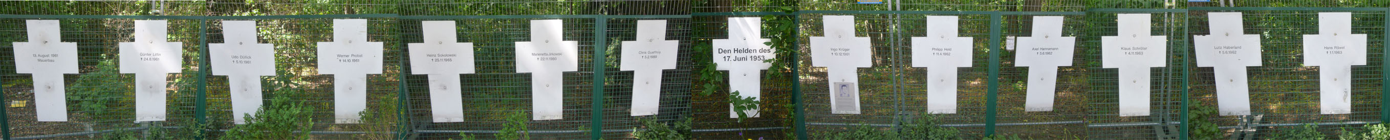
Back on the other side of the street, I asked the guide about the crosses. He indicated that some 80 people died trying to cross the wall, and that white crosses can be found along the route of the wall commemorating them. This group, he said, was put up by a private individual and there was some controversy about him. In doing this page, I found out that he is Gustav Rust, 67, a former East German prisoner who has devoted himself to publicly paying tribute to the victims of the communist regime. He is supposed to be on the street somewhere most all the time, but I did not see him. Rust sat in a GDR prison for several years, and he is determined to make sure that the injustices he suffered do not go forgotten.
The Brandenburg Gate and Pariser Platz
|
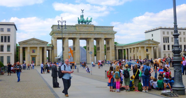
We walked south on the Eberstrasse until we came to the columns of the Brandenburg Gate; I had hoped that perhaps yesterday's event would have concluded and that we would be able to walk through the Gate itself (using one of the archways that cars used to use), but sadly the Gate was still blocked off. So we had to do what we did yesterday, which was turn and go through the east arcade into Pariser Platz, the square on the east side of the Gate.
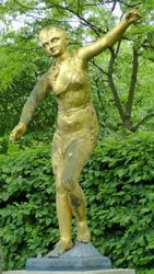
As we were going through the colonnade to get into the square, we passed a sculpture that I must have missed yesterday- a large statue of Minerva- the Roman goddess of wisdom and strategic warfare. Then we all came through the forest of columns and out into Pariser Platz, which used to be, of course, in East Berlin. As it turned out, we would spend most of the rest of our tour in what was once East Berlin.
|
The Gate is located at the eastern end of the Tiergarten, at the junction of Unter den Linden and Ebertstrasse, immediately west of the Pariser Platz. It is the monumental entry to Unter den Linden, the renowned boulevard of linden trees, which led directly to the royal City Palace of the Prussian monarchs. Throughout its existence, the Brandenburg Gate was often a site for major historical events and is today considered not only as a symbol of the tumultuous history of Europe and Germany, but also of European unity and peace.
In 1688, shortly after the Thirty Years' War and a century before the Gate was constructed, Berlin was a small walled city within a star fort with several named gates. Relative peace, a policy of religious tolerance, and status as capital of the Kingdom of Prussia facilitated the growth of the city. The Brandenburg Gate was not part of the old fortifications, but one of 18 gates within the Berlin Customs Wall erected in the 1730s, including the old fortified city and many of its then suburbs.
The new gate was commissioned by Frederick William II of Prussia to represent peace, and it was built between 1788 and 1791, replacing the earlier simple guardhouses which flanked the original gate in the Customs Wall. The gate consists of twelve Doric columns, six to each side, forming five passageways. Citizens originally were allowed to use only the outermost two on each side. The gate's design is based upon the Propylaea, the gateway to the Acropolis in Athens, Greece, and is consistent with Berlin's history of architectural classicism.
|
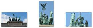
Atop the gate is a Quadriga- a chariot drawn by four horses. The Quadriga was common atop triumphal gates in Classical times. The one placed atop the Brandenburg gate in the 1790s was sculpted by Johann Gottfried Schadow.
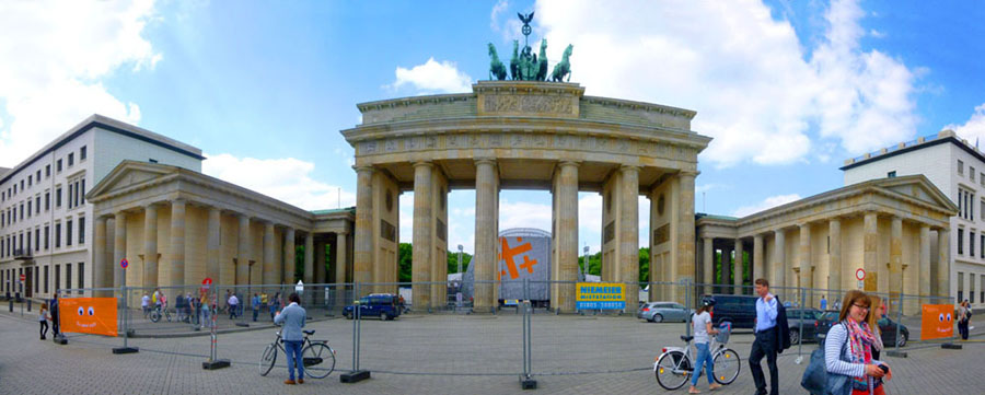
It is really a shame that there were so many barriers and signs up, spoiling any attempt to get a classic view of the gate. While one can, of course, find numerous views taken by professional photographers under ideal conditions on the Internet, it is still always any tourist's goal to get their own pictures- solidifying the memory of actually being there. I should have thought to ask Fred or maybe even the whole group to pose at the left, but I didn't. Even so, I found myself wishing that we had arrived at the Gate on a day or at a time that no special event was going on.
The Brandenburg Gate has played different political roles in German history. After the 1806 Prussian defeat at the Battle of Jena-Auerstedt, Napoleon was the first to use the Brandenburg Gate for a triumphal procession, and for good measure took its Quadriga to Paris. After Napoleon's defeat in 1814 and the Prussian occupation of Paris by General Ernst von Pfuel, the Quadriga was restored to Berlin. It was redesigned by Karl Schinkel for the new role of the Brandenburg Gate as a Prussian triumphal arch; the goddess, now definitely Victoria, was equipped with the Prussian eagle and Iron Cross on her lance with a wreath of oak leaves.
|
From 1814 to 1919, only the royal family was allowed to pass through the central archway, although the Kaiser also allowed members of the Pfuel family to use the archway as well. The Kaiser granted this honour to the family in gratitude to Ernst von Pfuel, who had overseen the return of the Quadriga to the top of the gate. In addition, the central archway was also used by the coaches of ambassadors on the single occasion of their presenting their letters of credence to council. From the end of the first World War (the end of the German Monarchy, use of the Gate was greatly expanded, although still controlled.
|
(NOTE:
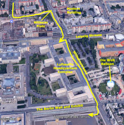
Later in our tour today we will visit the former headquarters of the Luftwaffe, and as it turns out, we will see posted there a picture of what the Brandenburg Gate looked like at the end of the war. The view looks west from Pariser Platz through the Gate towards the Tiergarten, and you can have a look at that amazing image
here.
Just to the east of the Brandenburg Gate is Pariser Platz, a central square here in Berlin. The square is named after the French capital Paris in honor of the anti-Napoleon Allies' occupation of Paris in 1814, and is one of the main focal points of the city. The neo-classical Brandenburg Gate became the west boundary of Pariser Platz when it was completed in the early 1790s. Until 1814 the square was known simply as QuarrÕ or Viereck (the Square). In March 1814, when Prussian troops along with the other Allies captured Paris after the overthrow of Napoleon, it was renamed Pariser Platz to mark this triumph.
|
Before World War II, Pariser Platz was the grandest square in Berlin, flanked by the American and French embassies, the finest hotel (the Adlon Hotel), the Academy of the Arts, and several blocks of apartments and offices. During the last years of World War II, all of the buildings around the square were turned to rubble by air raids and heavy artillery bombardment. The only structure left standing in the ruins of Pariser Platz was the Brandenburg Gate, which was restored by the East Berlin and West Berlin governments. After the war and especially with the construction of the Berlin Wall, the square was laid waste and became part of the death zone dividing the city.
When the city was reunited in 1990, there was broad consensus that the Pariser Platz should be made into a fine urban space again. The embassies would move back, the hotel and arts academy would be reinstated, and prestigious firms would be encouraged to build round the square. Under the rules of reconstruction, eaves heights had to be 22 meters, and buildings had to have a proper termination against the sky. Stone cladding was to be used as far as possible. Interpretations of these constraints, however, have varied to a great extent.
Wilhelmstrasse
|
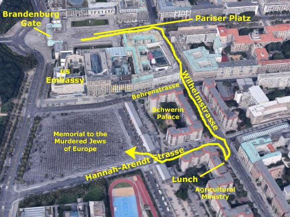
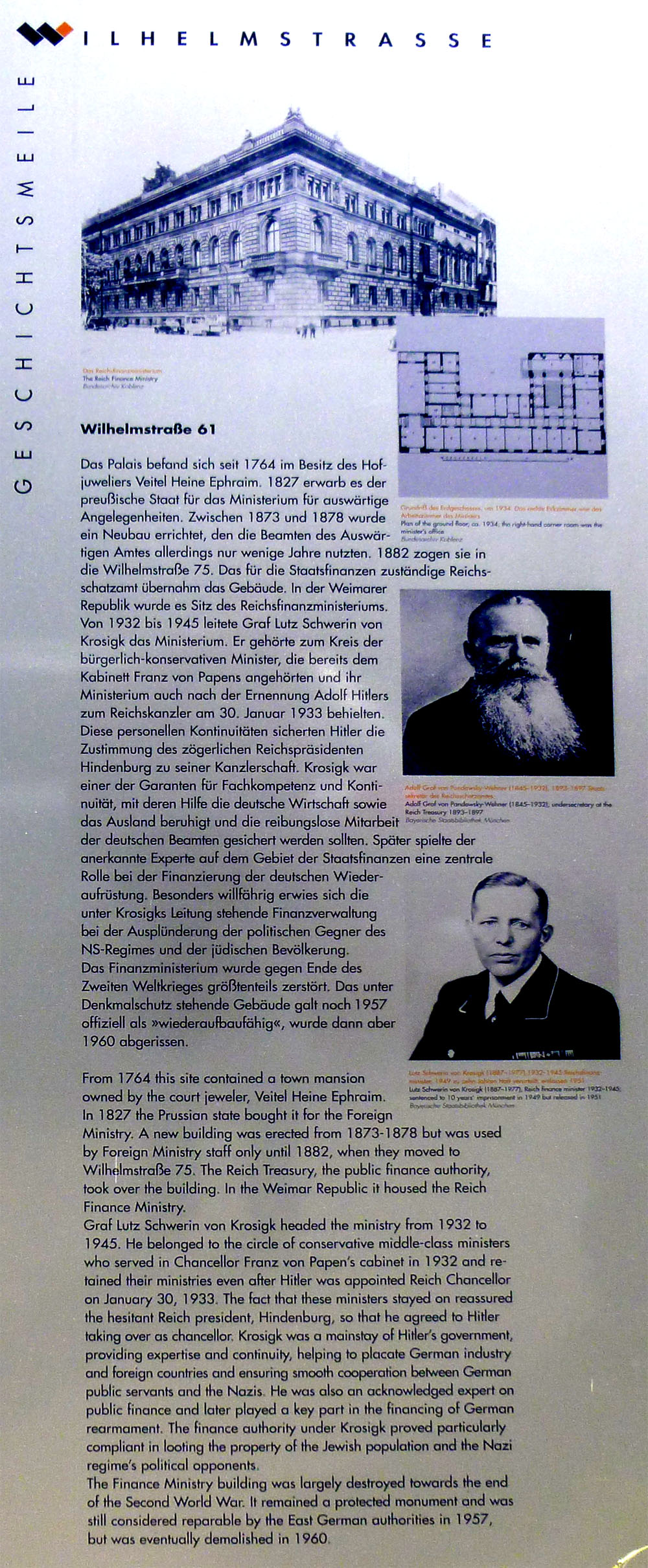
In the next two blocks, our guide took us through some history of the area, and there were also some historical markers along the street, echoing his narrative. The first block south of Behrenstrasse on the west side of Wilhelmstrasse was, for example, the site of a palace that the Earls of Schwerin built in 1737.
|
The Reich President was the head of state of the Republic. He was supreme commander of the armed forces and had the power to sign and promulgate laws, appoint and dismiss the Reich Chancellor and dissolve the Reichstag. Paragraph 48 of the Weimar Constitution enabled him to issue emergency regulations in case of danger to the public security and order, and to repeal important basic laws. From 1930 Hindenburg made increasing use of these powers, which contributed to the collapse of the Weimar Republic and the rise of Adolf Hitler.
After Hindenburg's death in August 1934, Hitler amalgamated the offices of the Reich President and the Reich Chancellor and took on the post himself. From then on, the palace was only used for state occasions. From 1939 Reich Foreign Minister Joachim von Ribbentrop used the building as his government apartment.
The palace was badly damaged in the Second World War. After the war, the East German state gave it cultural heritage status and considered rebuilding it as a guest house for the Berlin City Council, but it was eventually demolished in 1960. At the end of the 1980s the East Germans built prefab high-rise blocks here; these still survive today. The site of the old palace gardens to the west has become part of th eMemorial to the Murdered Jews of Europe.
|
In June, 1933, the Reich Farmers' Leader, Walther Darre, took over the Ministry. Darre also headed the SS Office for Race and Settlement and was regarded as a theorist of Nazi agricultural policy. He coined the slogan "Blut und Boden" ("blood and soil", a phrase which has been in the news lately as I write this, having been chanted by neo-Nazis in a conflict in Charlottesville, Virginia) and saw the peasantry as the core of a new "master race" that should be strengthened. To promote this, the Reich Hereditary Farm Law was passed in 1933, prohibiting hereditary farms from being sold or split up through inheritance.
That same year, Darre took charge of all the farmers and farming federations, incorporating them into the "Reichsnahrstand", a central authority he set up to take control of the agricultural sector. After WWII began, Darre lost much of his influence, and in 1942 was replaced.
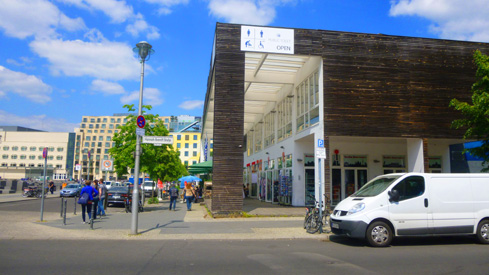
The ministry was bombed towards the end of the war and demolished in 1962. The site, which was near the Berlin Wall, remained vacant until the mid-1980s, when one of the East German prefab blocks was built on the site. As it turned out, the little cafe where we stopped for a drink and a pastry was one of the ground-floor commercial establishments in the pre-fab block that was built on the site of the Agriculture Ministry. Across the street was another new building that was constructed by the East Germans in the 1980s; it is now a local government office.
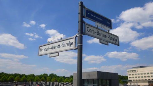
After our refreshment stop, we walked back up to Hannah-Arent Strasse and turned west towards the memorial. Just before we got to it, we passed a toy store with a very topical window display.
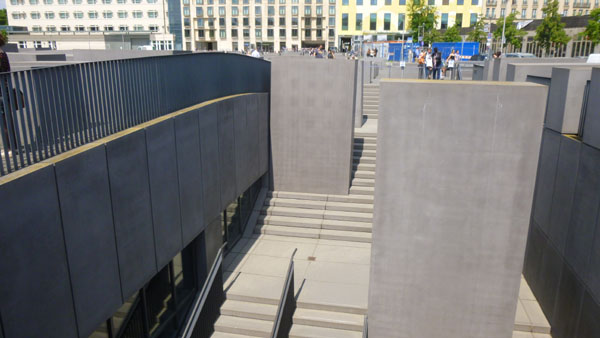
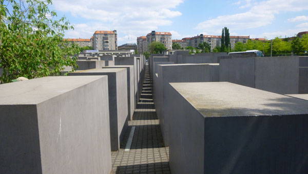
The Memorial to the Murdered Jews of Europe
 Holocaust Memorial Center |
 At the Corner |
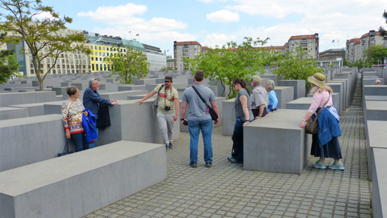
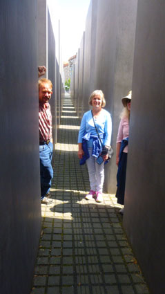
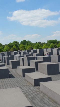
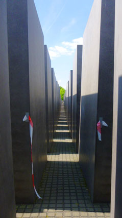
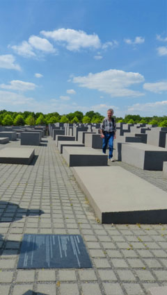
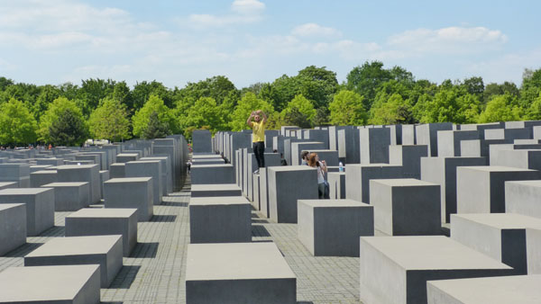
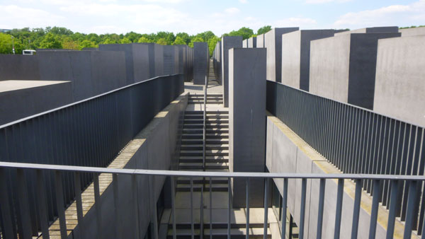
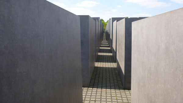
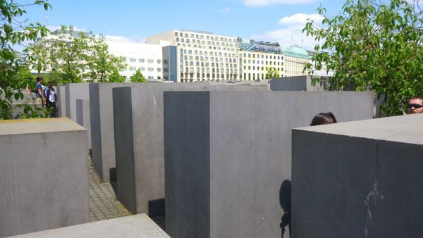
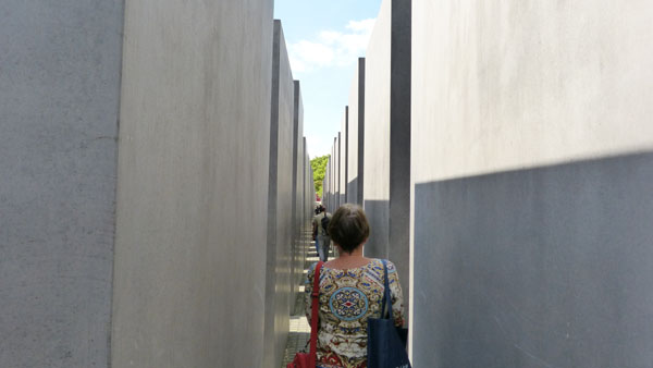
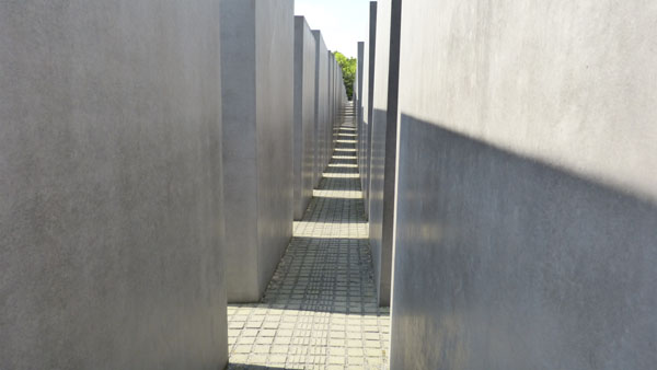
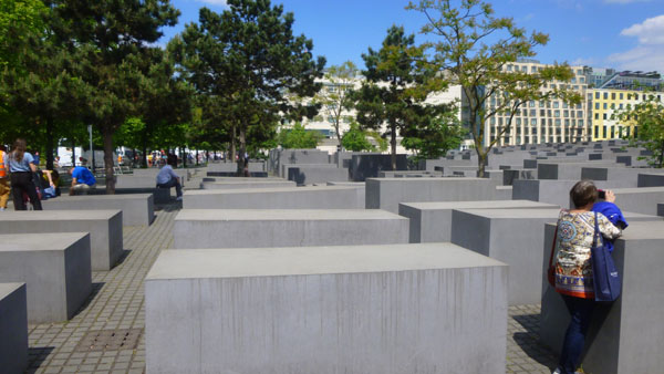
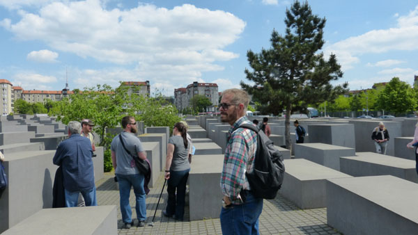
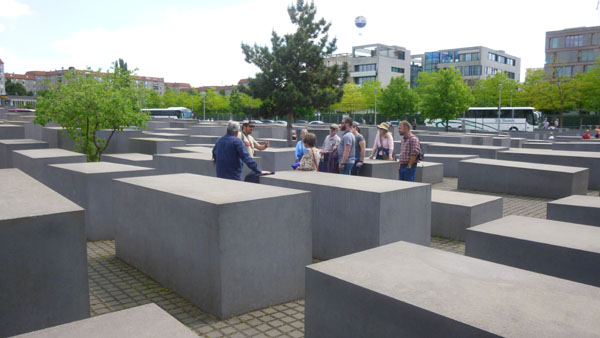
The Memorial to the Murdered Jews of Europe, also known as the Holocaust Memorial, was designed by architect Peter Eisenman and engineer Buro Happold. It consists of a 4.7-acre site covered with 2,711 concrete slabs or "stelae", arranged in a grid pattern on an undulating field. The stelae are are all the same width and length (about 3 feet by 8 feet), but have heights that vary from eight inches to over 15 feet. They are organized in rows, 54 of them going northsouth, and 87 heading eastwest at right angles but set slightly askew. An attached underground "Place of Information" holds the names of approximately 3 million Jewish Holocaust victims, obtained from the Israeli museum Yad Vashem. Our guide stopped with us at the memorial's southeast corner to give us some of the history, but most of all talked about how the memorial is regarded locally.
|
The monument is located on the former location of the Berlin Wall, where the death strip once divided the city. It acts as a focal point, connecting the various holocaust monuments spread across the city and the country; the monument provides a central reference point for visitors. According to one description, "The center represents a central focus on the diverse memorial sites across Germany which stress the living memory aspect of remembrance. In Berlin an example of this is the Stolpersteine (tripping stones) initiative plaques on street pavements, usually outside a house's main entrance, commemorating deported Jewish residents".
The monument is composed of 2711 rectangular concrete blocks, laid out in a grid formation; this allows for long, straight, and narrow alleys between them, along which the ground undulates. The installation is a living experiment in montage. People have applauded the location of the memorial. During the war, the area acted as the administrative center of Hitler's killing machine. His chancellery building, designed by Albert Speer and since demolished, was a few hundred yards away just to the south; his bunker lies beneath a nearby parking lot. The memorial is located near Berlins foreign embassies, allowing political diplomats and leaders from around the world to observe how Germany acknowledges its past while continuing to move forward.
|
However, observers have noted the memorial's resemblance to a cemetery, and that is the most common interpretation. It is a graveyard for those who were unburied or thrown into unmarked pits, and several uneasily tilting stelae suggest an old, untended, or even desecrated cemetery. Many interpret the grid as a reminder of the killing machine that was created. Others have remarked that the memorial is a place to grasp loneliness, powerlessness and despair. I found this to be true; the monument seems to isolate the visitor from the world surrounding it- as the Jews were isolated from their world and then removed from it.
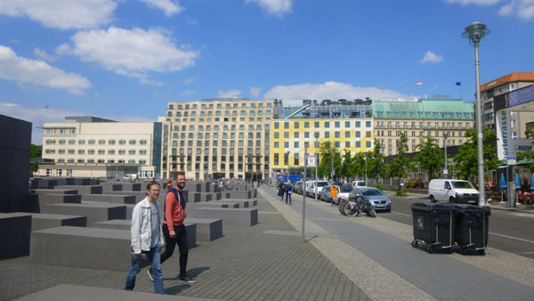
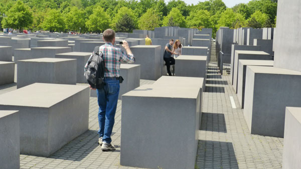
Perhaps not so oddly, the memorial didn't seem to be an appropriate place for the typical "And here we are in front of..." kind of picture. Most of the ones we all took had few, if any, people in them. Perhaps the best way to show some of our pictures in in a slideshow, and there is one below, left.
|
|
The debates over whether to have such a memorial and what form it should take extend back in the late 1980s, when a small group of private German citizens, led by a television journalist, Lea Rosh, and a historian, Eberhard Jðckel, neither of whom is Jewish, first began pressing for Germany to honor the six million Jews murdered in the Holocaust. Rosh founded a group to support its construction and to collect donations. With growing support, the Bundestag passed a resolution in favor of the project. On 25 June 1999, the German Federal Parliament decided to build the memorial as designed by Peter Eisenman. A federal foundation was established to run it. Since it was opened in 2005, more than six million people have visited the memorial.
As you would expect, our guide told us, the memorial has garnered perhaps more than its share of criticism. Some have mentioned that other groups were equally persecuted. (In response, other memorials have been established for some of these groups.) Many critics argued that the design should include names of victims and other information, while others prefer the cold abstraction of the memorial. Some have said that it is no longer appropriate to have, as a German novelist has put it, this "ceaseless presentation of our shame." Others, of course, think the memorial doesn't go far enough in that regard. I think our guide, who isn't German, still summed up the feelings of his German friends and associates when he said that the prevailing opinion seems to be that the memorial is to remind us of a "mind-set" of which Hitler's Germany was only one recent example. Of course, few Germans were even alive when the concentration camps were active, and almost none of them were even old enough to bear any responsibility.
I made two movies here at the memorial. In the first (left-hand movie player below), which begins just after our guide's introduction, surveys the site and then follows me into the memorial. (The first few seconds are a bit out of focus.) The second was my attempt to capture the impersonality of the stellae, as I wander through them, turning first this way and then that.
|
|
Potsdamer Platz and Hitler's Bunker
|
|
|
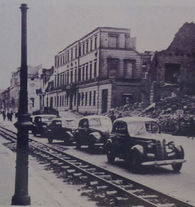
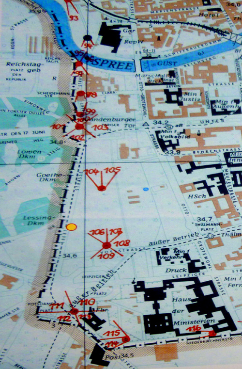
We continued walking down Ebertstrasse, which borders the Tiergarten and leads further south to Potsdamer Platz, crossed another street, and came to a display of photographs that showed what this area looked like when the Berlin Wall was in place. Below are to pictures of the exhibit introduction; the map is in a scrollable window.
 |
 |
And here are two of the photographs that were lined up in the exhibition along Ebertstrasse:
|
|
The photos look grim and forbidding- which is, I suppose, what the East Germans intended. Today, the area is completely different, as evidenced by all the development that has gone on in the last 25 years. For example, you can see the view today across the street and the area on the side street just behind the exhibit.
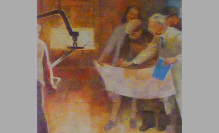
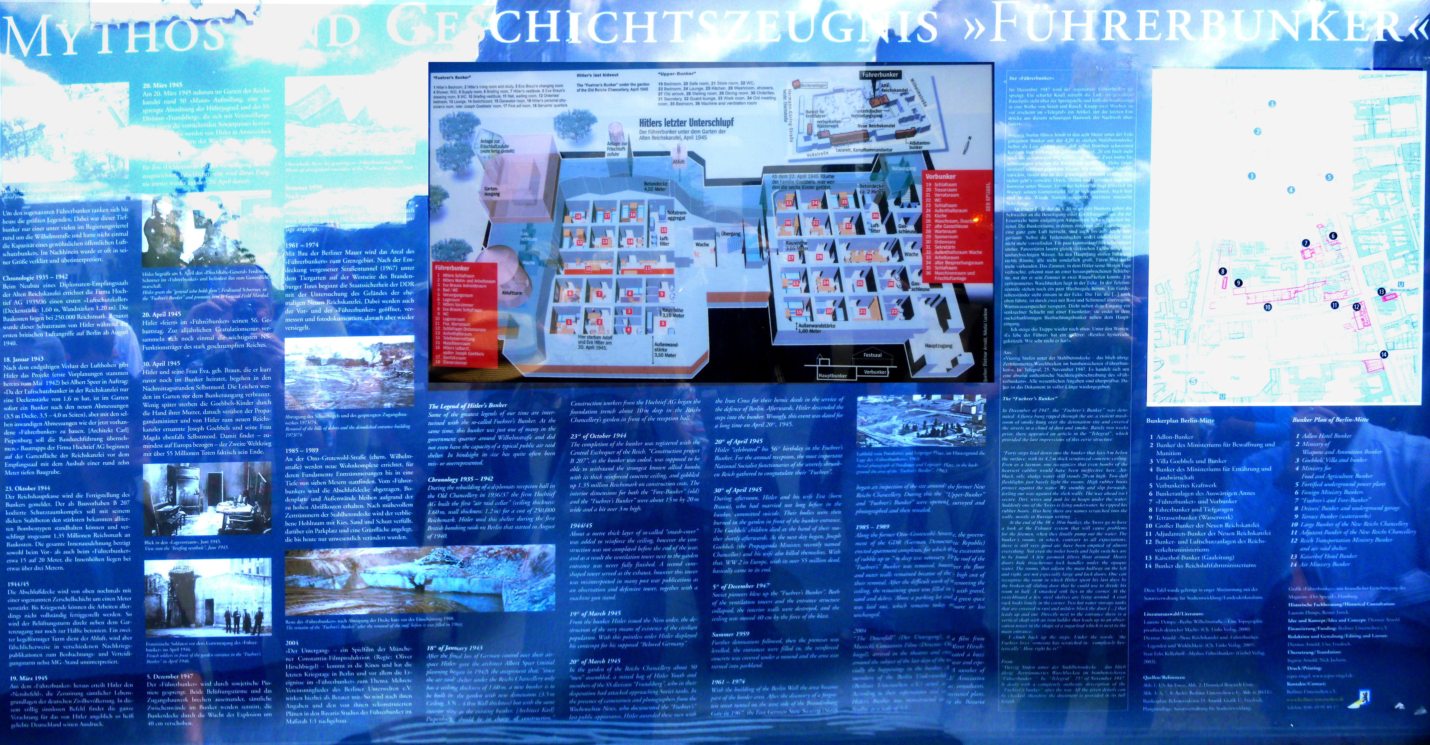
Around the corner and one block east we came to Gertrud-Kolmar Strasse, and across the street was what appeared to be a parking lot for a series of buildings (residential or commercial, I wasn't sure). Actually, it was a parking lot. The only evidence that this was the site of Hitler's Bunker (and, according to accounts, the place where he and Eva Braun committed suicide) was a large display sign. The sign was in German and English with numerous pictures and diagrams. Since it wasn't possible to take pictures of the bunker itself (as it is buried way below ground), I had to content myself with taking pictures of the sign. I think the best way for me to show you what's here (in addition to the aerial view above) is to let you read the sign for yourself. So I stitched together a single image of the sign and tried to adjust it so it was all readable (which involved taking a separate picture of the bunker diagram and overlaying it on the picture of the whole sign. I have put this very large image in the scrollable window below. The English portion begins below the left corner of the bunker diagram, but all the images have English explanations as well.
From Hitler's bunker, our group turned and walked south along Gertrud-Kolmar Strasse towards Volkstrasse and the newly-constructed Mall of Berlin (a huge enclosed shopping mall).
Our Tour Goes to the Berlin Wall
|
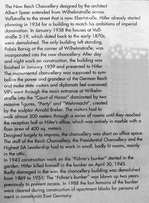
Walking down Volkstrasse (that view looked west, and the Mall of Berlin complex is at the left) towards Wilhelmstrasse, we passed what seemed to be a school with a playground in front. As it turned out (as we learned from a nearby historical marker) was the site of the former New Reich Chancellery designed by Albert Speer. If you'd like to learn more about the building, read the historical marker in the scrollable window below:
We continued east on Volkstrasse, reaching Wilhelmstrasse- the same street on which we'd stopped for refreshments earlier. The intersection is known as Wilhelmplatz, even though it isn't a large square now. Near the intersection was the statue of Leopold I, Prince of Anhalt-Dessau (1676-1747), a Generalfeldmarschall in the Prussian army, remembered as the commander who modernized the Prussian infantry. Leopold distinguished himself during the War of the Spanish Succession and the Great Northern War against Sweden. His last great achievement was commanding the Prussian troops to victory over the Saxons at the Battle of Kesselsdorf in 1745 during the Second Silesian War.
While there are modern buildings at Wilhelmplatz now, the square used to be home to a number of historic structures. There were two informative signs here- one about Wilhelmplatz, the square dating to the beginning of the 18th century, and another for one of the grand palaces that used to exist here. You might find both of these signs interesting, and you can read each of them in the scrollable windows below. (The top part of each sign is in German, but if you will scroll down, there is an English translation.)
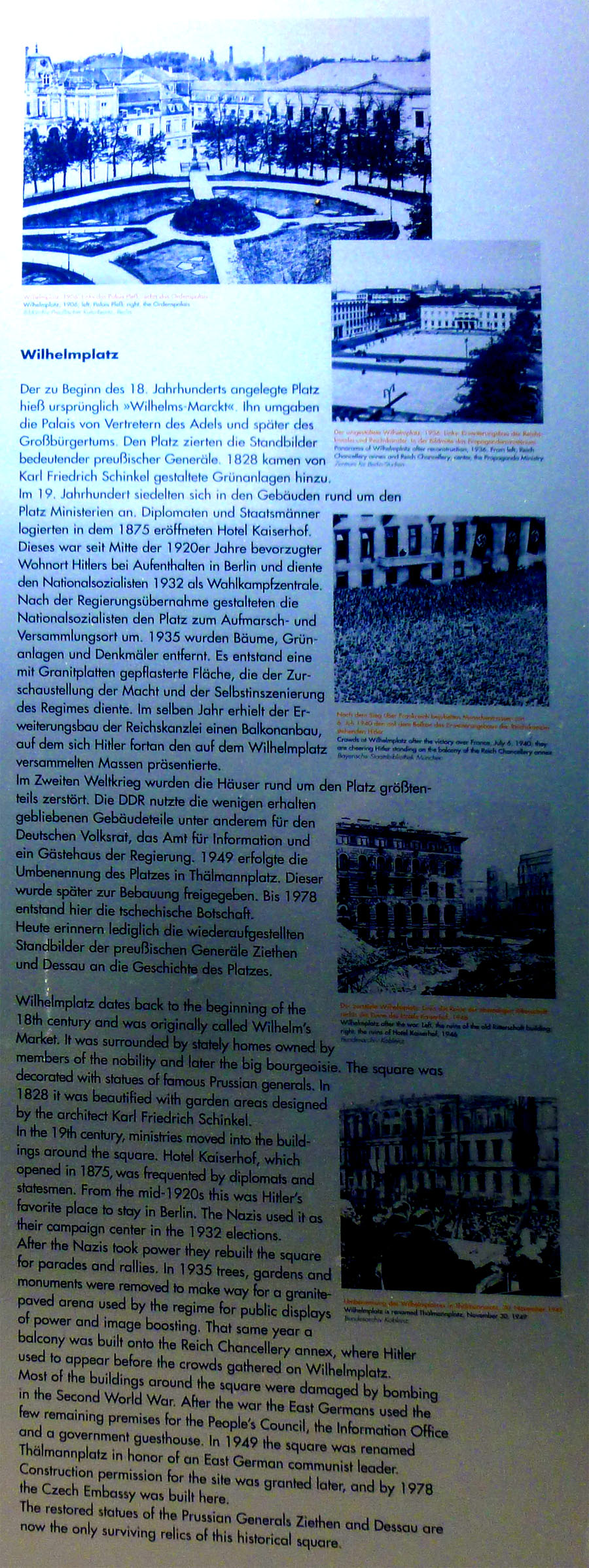
In the 1730s the northern part of Wilhelmstrasse btween Unter den Linden and Leipziger Strasse (one more block south of where I am standing at the moment) became a posh residential area for prominent people in the Prussian public administration. In the 19th century the major Prussian ministries were based here, joined from 1871 by the ministries of the German Reich. Under the Nazis the government quarter was extended to include the headquarters of the SS and police system of terror.
After 1945 the street lay in Berlin's eastern sector. The few surviving buildings were used for East German government offices. In honor of two founders of the communist East German state, Wilhelmplatz was renamed Thalmann Platz in 1949 and Wilhelmstrasse became Otto-Grotewohl Strasse in 1964. The original street names were restored in 1993. Today the area houses German ministries, embassies and centers of remembrance.
|
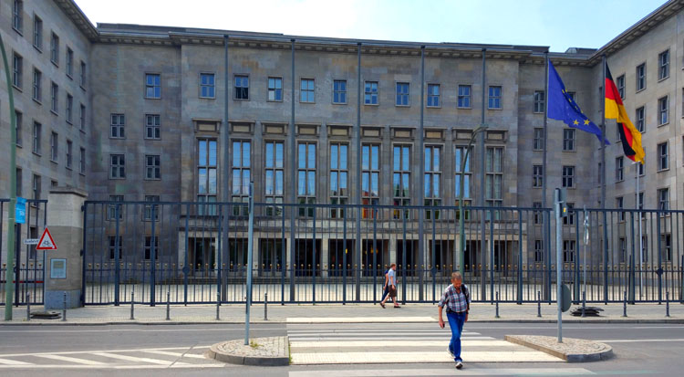
A classic example of muscular Nazi architecture, the former Reich Air Ministry (Reichsluftfahrtministerium) on Wilhelmstrasse was built on the orders of Reichsmarschall Hermann G—ring between 1935 and 1936. At the time the largest office building in Europe, the vast edifice- with its 2,800 rooms, 4 miles of corridors and over 4,000 windows- served the ever-growing administrative needs of the Luftwaffe.
Incredibly, it survived wartime bombing virtually unscathed, and following Germany's defeat served first as a center for the Soviet military, then later as headquarters to the GDR Council of Ministers under the name Haus der Ministerien.
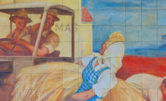
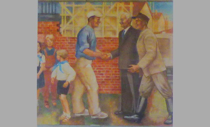
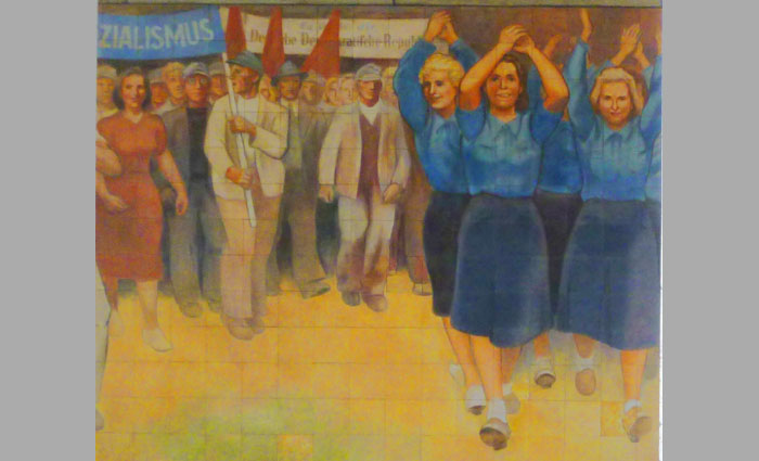
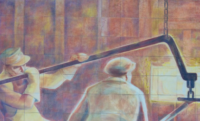
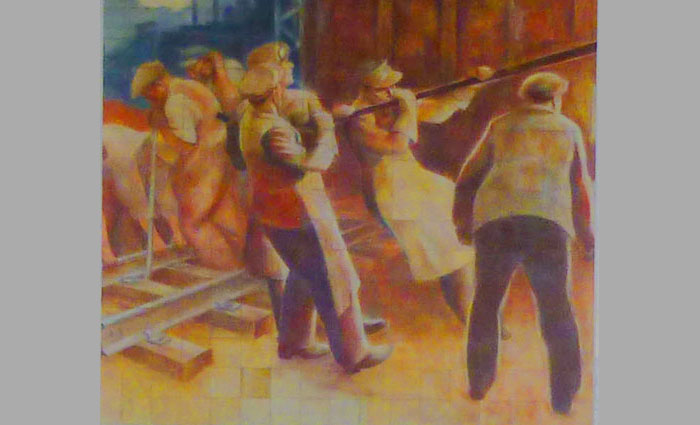
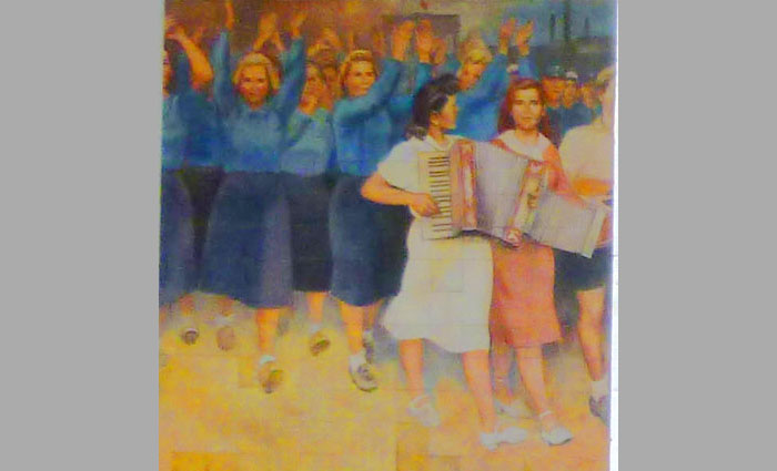
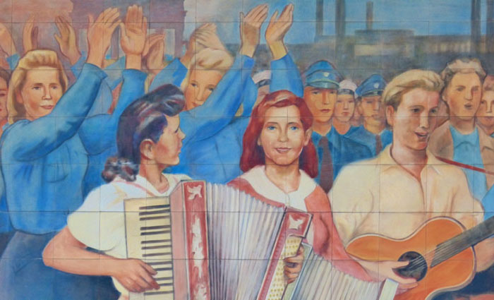
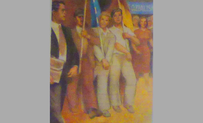
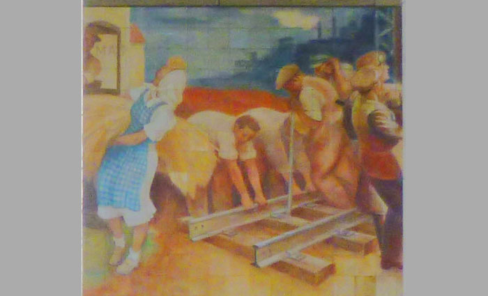
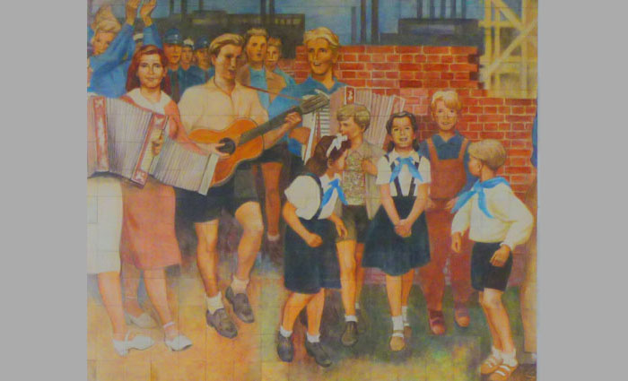
While many of the original interior fittings were (perhaps surprisingly) left untouched by the GDR administration, in 1952 an enormous mural was added to the building's north facade along Leipziger Strasse- and that is what our guide wanted to stop and show to us. Created entirely from hand-painted Meissen porcelain tiles, the 18-metre tableau- a masterpiece of socialist art- depicts joyous East Germans celebrating life in the GDR.
|
|
But we did get some, and I've cropped most of them (to get rid of the barrier and the columns of the building itself) and put them in a slideshow. That show is at right. As usual, you can get from one picture to the next by clicking on the little arrows in the lower corners of each image.
I would have liked to have gotten closer, so we would take better pictures, but these will have to suffice. Enjoy the heroic nature of East German socialist art!
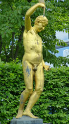
From the corner where we were looking at the mural, I noticed that further down Wilhelmstrasse there was some sort of balloon ride affair, and I had no idea what it was all about. And just as we passed the front of the Luftwaffe HQ complex (the entrance shown above), I noticed that there was a sculpture across the street, so I went to investigate. I should have recorded what it was about, as I can't seem to find it online, but you can see my two pictures of it here and here.
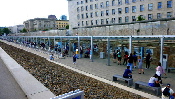
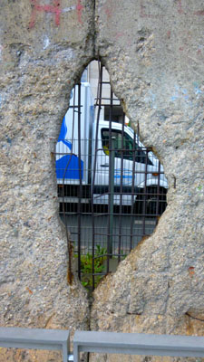
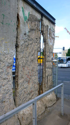
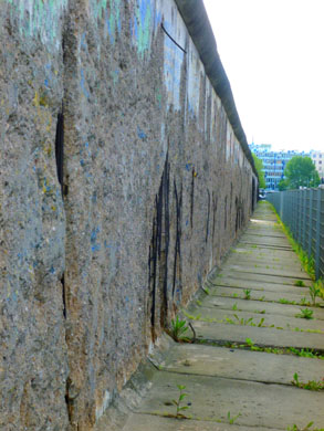
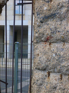
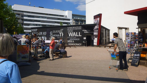
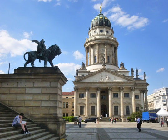
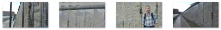
Walking south, we crossed Niederkirchnerstrasse and came to an open space- kind of a park- where there was a preserved portion of the Berlin Wall along the north side and in the center a building (the Topography of Terror) documenting Nazi atrocities.
|
The barrier included guard towers placed along large concrete walls, which circumscribed a wide area (later known as the "death strip") that contained anti-vehicle trenches and other defenses. The Eastern Bloc claimed that the Wall was erected to protect its population from fascist elements conspiring to prevent the "will of the people" in building a socialist state in East Germany. In practice, the Wall served to prevent the massive emigration and defection that had marked East Germany and the communist Eastern Bloc during the post-World War II period.
The emigrants tended to be young and well-educated, leading to the "brain drain" feared by officials in East Germany; numerous officials told the Central Committee about the significant number of East German intelligentsia who were among the citizens that left for West Berlin. While the East German leadership stated that citizens were leaving for economic reasons, testimony from refugees indicated that the reasons were more political than material. The flight of the intelligentsia- not just authors and artists but also doctors and scientists- had become critical.
|
|
 (Click on Thumbnails to View) |
On Saturday, 12 August 1961, the leaders of the GDR met and authorized an order to close the border and erect a wall. At midnight, the police and units of the East German army began to close the border and, by Sunday morning, 13 August, the border with West Berlin was closed. East German troops and workers had begun to tear up streets running alongside the border to make them impassable to most vehicles and to install barbed wire entanglements and fences along the 125-mile border around West Berlin. During the ensuing months, the wall was constructed and over the years "improved".
Before the Wall's erection, 3.5 million East Germans left the GDR (legally and illegally); between 1961 and 1989, the Wall prevented almost all such emigration; during that period, around 5,000 people attempted to escape over the Wall (some were successful, many were not, and between 140 and 200 were killed in the attempt).
|
|
These new regulations were handed to a party official, Gunter Schabowski, shortly before a scheduled press conference on 9 November. He ended up reading them aloud and, when asked by a reporter their effective date, he said that as far as he knew, they would take effect immediately. This part of Schabowski's press conference was broadcast on West German television news, which, of course, reached nearly all of East Germany as well. One anchorman said: "This is a historic day. The GDR has announced that, starting immediately, its borders are open to everyone. The gates in the Wall stand open wide."
Minutes after the broadcast, East Germans began gathering at all six checkpoints between East and West Berlin, demanding that border guards immediately open the gates. The surprised and overwhelmed guards made many hectic telephone calls to their superiors about the problem, but it soon became clear that no one among the East German authorities would authorize force (lethal or otherwise) to restrain the crowds. Finally, at 10:45 p.m., the first checkpoint commander yielded and ordered his guards to allow people through with little or no identity checking.
The Wall was effectively rendered useless as crowds of East Germans crossed and climbed onto the Wall, joined by West Germans on the other side in a celebratory atmosphere. Over the next few weeks, euphoric people and souvenir hunters chipped away parts of the Wall; the governments later used industrial equipment to remove most of what was left. The fall of the Berlin Wall paved the way for German reunification, which was formally concluded on 3 October 1990.
Fred and I had certainly heard a great deal about the Berlin Wall, having lived through its entire existence, so it was immensely interesting to finally see it in person. The block were the wall remnant and the Topography of Terror exhibit are was somber, but across the street (in the way we would be heading) it was a different story.
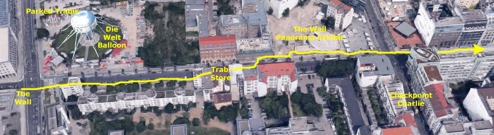
Checkpoint Charlie and the End of Our Tour
|
One was a tethered balloon on the north side of the street. I'd seen it from our stop at the Luftwaffe mural, but now I could see it up close, and discovered that it was, essentially, a carnival ride, sponsored by the daily newspaper Die Welt. I watched it go up and down, exchanging riders when it was sitting on the ground. It rose of its own accord, of course, but was tethered so it could be pulled down again. I assume that the views from its maximum height are pretty good.
|
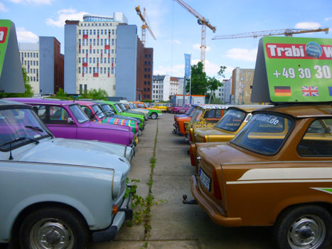
The Trabant is an automobile produced from 1957 to 1990 by former East German auto maker VEB Sachsenring Automobilwerke Zwickau in Zwickau, Saxony. It is often regarded as a symbol of the defunct East Germany and of the collapse of the Eastern Bloc in general. The car had a reputation for being uncomfortable, slow, noisy, and dirty. Nevertheless, it was very sought after in East Germany before the fall of the Berlin Wall. It had a hard plastic body mounted to a single-piece steel chassis, front-wheel drive, a transversely-mounted engine, and independent suspension all features that were unusual for the era in which it was manufactured.
Dubbed a "spark plug with a roof", over 3 million Trabants were made in a variety of models over a 30-year span, and there was very little change to the basic design in all that time. Older models of the car later became popular among collectors in the United States due to their low cost and fewer restrictions on importing antique cars. The Trabant also gained a following among car turing enthusiasts and for use in rally racing and other motorsports.
The engine for the Trabant was a small two-stroke engine with two cylinders, giving the vehicle modest performance. With a curb weight of just over 1100 pounds, the Trabant delivered 26 horsepower from its 600 cc engine displacement. It took 21 seconds to accelerate from a stop to its top speed of 62 mph.
|
Having no oil injection system, two-stroke oil had to be added to the 6-gallon gas tank every time the car was filled up. Gas stations of the time, in countries where two-stroke engines were common, served premixed gas-oil mixture from the pump. Today, owners have to carry their own oil. The car also lacked a fuel pump, so the gas tank was on top of the engine so gravity could do the work. This, of course, increased the risk in front-end accidents. Earlier models had no fuel gauge; a dipstick was inserted into the tank to determine how much fuel remained. The Trabant had a dull color scheme, which is why current owners have them painted in psychedelic colors, and had a cramped, uncomfortable ride. The last model was introduced in 1964. Today, the car has "cult status" and is an object of playful ridicule- standing in for the drab inefficiency of the Eastern Bloc.
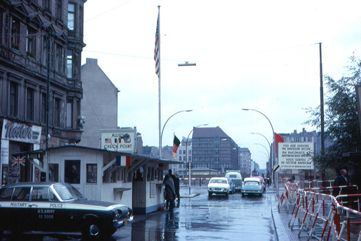
We continued down the street towards Checkpoint Charlie, and the first thing we noticed was that the entire area had been kind of overcommercialized with touristy attractions- like this indoor panorama of the wall (at least that's what I guess it was). Anyway, here's one of those attractions and then my movie of the intersection right at the checkpoint:
|
|
Checkpoint wasn't quite what I expected, although I'll admit that I wasn't sure what I expected in the first place. I guess I expected something like the Brandenburg Gate, but that isn't what we saw.
|
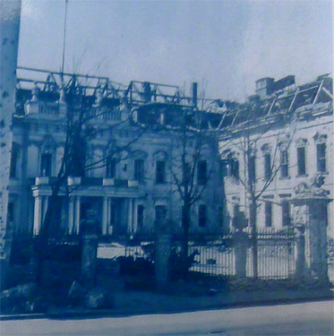
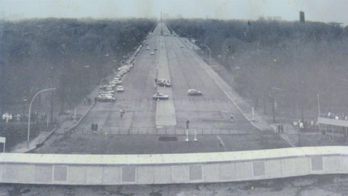
The picture at left is not, of course, a picture that we took; it is an archive picture that shows the checkpoint as it existed in 1963. After the dissolution of the Eastern Bloc and the reunification of Germany, the building at Checkpoint Charlie became a tourist attraction. It is now located in the Allied Museum in the Dahlem neighborhood of Berlin.
So what did we see? Well, the passage of time has worked its magic. Not only that, but more importantly the reunification of Germany has worked its magic, and the dismal, gray scene that you can see in the picture above has disappeared.
|
The actual checkpoint building is, as I mentioned above, in a museum; the one that is there now is a reconstruction of the original. But if you look at the old pictures, you'll also notice that the death strip along the Wall is also gone, replaced by new buildings and an active commercial center. I wonder how this area would look today had it not been for 40 years of being held back by East Germany.
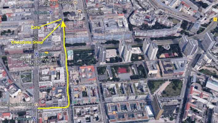
Checkpoint Charlie was the last major stop on our tour, which then continued another block east and then headed north on Charlottenstrasse towards the Gendarmenmarkt. On the way, our guide kept up a rambling account of how this entire area was completely rebuilt after the Berlin Wall came down; a few of the buildings are old, but most of them were constructed in the last 25 years.
|
(Click on Thumbnails to View) |
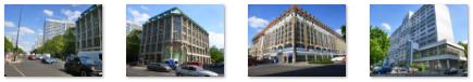
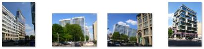
Most of this avenue (English: Charlotte Street) was in the former East Germany, and one of that nation's signature projects- the Leipziger Strasse Complex- was built in the Leipziger Strasse in the Mitte district between 1969 and 1982 on both sides of the road between Spittelmarkt and Charlottenstrasse. The buildings, some of the most modern in the Soviet Bloc, were designed as residences for influential members of the government and of Communist society. The buildings were completely renovated after the Berlin Wall came down. There are two pictures of this row of buildings in the group above, and you can also see them in the aerial view.
Fred took just a few pictures as we walked north. One of them is a closeup of sculptures adorning a building we passed (and my photograph of which is in the collection above). Another was a closeup of a statue of a winged horse atop one of the buildings along the avenue. We continued north until we reached the southwest corner of an area known as the Gendarmenmarkt. There was a chocolate shop on one corner and a cafe where Ron, Fred, and I stopped for a drink. Prudence and Nancy took a taxi back to the Hotel Am Steinplatz and Karl joined us. Fred and I left to explore the Gendarmenmarkt and Ron and Karl caught another cab back to the hotel.
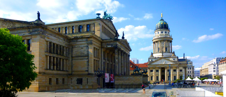
The Gendarmenmarkt
|
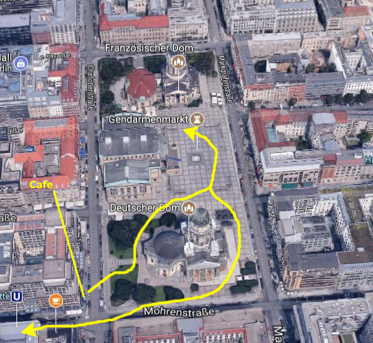
During World War II, most of the buildings were badly damaged or destroyed. Today all of them have been restored- and quite beautifully, I might add. Let's take a walk through the square. On the aerial view above, I marked our approximate route, but that's not particularly important. As you can see, we crossed the street in front of the cafe, and walked across the small lawn between the Deutscher Dom (German Church) and Charlottenstrasse. You can see a second view of that lawn looking northwest across Charlottenstrasse here. First, let's take a look at the German Church.
|
The Neue Kirche (English: New Church), is the parish church for northern part of the then new quarter of Friedrichstadt. The Lutheran and Calvinist (in German Reformed Church) congregants used German as their native language, as opposed to the French-speaking Calvinist congregation owning the French Church. The congregants' native language combined with the domed tower earned the church its colloquial name "Deutscher Dom". The church is not a cathedral in the actual sense of the word.
The first church on this site was built in 1701-1708; it was the third church in Friedrichstadt, the town having been established in 1688. Friedrichstadt was a town of princely domination, while the neighboring old Berlin and C—lln were cities of town privileges. The Prince-Elector originally only provided for a Calvinist congregation, since the Hohenzollerns were themselves Calvinists. More and more Lutherans moved in, and in 1708 the New Church became both Calvinist and Lutheran.
The original building had a pentagonal groundplan with semicircular apses. The interior was characterised by a typical Protestant combined altar and pulpit leaning against the eastern central pillar opposite to the entrance. In 1780, construction began on a tower for the east side of the church, but in 1781 the tower collapsed while still under construction. It was rebuilt and a dome added over the center of the nave. The statues represent characters from the Bible, and the dome was topped by a statue symbolizing the victorious virtue. The gable relief depicts the Conversion of St. Paul of Tarsus.
In 1881 the dilapidated prayer hall was torn down and replaced with a new one on a pentagonal groundplan, according to a Neo-Baroque design, and six new statues were added to the attic of the new hall. By 2001, the various congregations of the New Church had united to become today's "Evangelical Congregation in the Friedrichstadt". In 1943 the New Church was almost completely destroyed in the bombing of Berlin; the reconstruction of the church was not completed until 1988, after The German government had acquired the building and the site. The church building was updated with a new domed tower constructed, deconsecrated and reopened in 1996 as the Bundestag's museum on German parliamentary history. The former congregations still exist, but hold their services in the French Church.
The views from the center of the square were spoiled by what was apparently (like at the Brandenburg Gate) some sort of preparation for an event that will be (or was) held in the square, but here are the two best pictures we got:
 |
 |
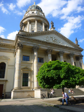
On the west side of the Gendarmenmarkt is the Konzerthaus Berlin- the concert housing the German orchestra Konzerthausorchester Berlin. Built as a theatre from 1818 to 1821 under the name of the Schauspielhaus Berlin, later also known as the Theater am Gendarmenmarkt and Kom—die, its usage changed to a concert hall after the Second World War and its name changed to its present one in 1994.
|
The new K—nigliches Schauspielhaus was inaugurated on June 18, 1821 with the acclaimed premiere of Carl Maria von Weber's opera Der Freisch■tz. Other works that have premiered at the theatre include Undine by E. T. A. Hoffmann in 1816. During the 1848 Revolution its main auditorium housed the Prussian National Assembly for several weeks in September, with the Gendarmenmarkt a major arena of political events.
After World War I the Schauspielhaus reopened in 1919 under the name of Preussisches Staatstheater Berlin. Under the direction of Leopold Jessner it soon became one of the leading theatres of the Weimar Republic, a tradition ambivalently continued by his successor Gustaf Gr■ndgens after the Nazi takeover in 1933, including his famous staging of Goethe's Faust and the premiere of Gerhart Hauptmann's tragedy Iphigenie in Delphi in 1941.
Severely damaged by Allied bombing, the building was rebuilt from 1977 onwards and reopened as the concert hall of the Berliner Sinfonie-Orchester in 1984 with a gala concert. The exterior, including many of the sculptures of composers by Christian Friedrich Tieck and Balthasar Jacob Rathgeber, is a faithful reconstruction of the original design, while the interior was adapted in a Neoclassical style meeting the conditions of the altered use. The great hall is equipped with a notable four-manual pipe organ built in 1984; it has four manuals and pedal, 74 stops and 5,811 pipes. In 1994 the venue was renamed the "Konzerthaus Berlin", and is now, in terms of acoustics, considered to be amongst the five best concert venues in the world for music and/or opera.
|
As you can see in the pictures, there was a large sculpture at the base of either side of the stairs up to the Konzerthaus; they were very interesting and Fred got good closeup pictures of both of them:
 (Click on Thumbnails to View) |
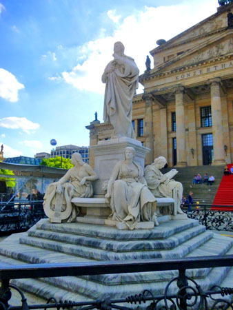
There were two more structures of interest here in the Gendarmenmarkt- the monumental statue of Friedrich Schiller in front of the Konzerthaus, and the French Church at the north end of the square.
|
In 1859, celebrations of the 100th birthday of Friedrich Schiller (17591805) occurred throughout Germany. In Berlin funds were raised to erect a monument for the purpose, with Crown Prince Wilhelm (later Kaiser Wilhelm I) and the city of Berlin each donating 10,000 Thaler and the population 12,680 Thaler. On 10 November the foundation stone for the planned monument was laid, although a specific design did not yet exist; the proposal by Begas was chosen (and this made his career). The Franco-Prussian war of 1870/71 delayed the unveiling, which took place in 1871. The occasion was used to lay out a garden on the central part of Gendarmenmarkt, which was renamed Schillerplatz at the close of that year. This name remained until 1936.
The statue of the poet stands on a cube-shaped pedestal surrounded by four semicircular basins, above which there are water spouts in the form of lion heads. Although the memorial has the design of a fountain it was never used as such. Schiller wears a crown of laurel leaves and is depicted as a young, self-assured man. Four allegorical figures sit on the edges of the basins and depict the writers main areas of creative activity- Lyric Poetry, Tragedy, History, and Philosophy. The pedestal bears inscriptions relating to Schiller and two small bas reliefs which show Schiller receiving a lyre from the muses and being introduced to great writers of former times.
In 1936, the Third Reich turned the Gendarmenmarkt into a parade ground. The decorative gardening was removed, and the Schiller monument was dismantled and put into storage. There is a bronze copy in the southern part of Schiller Park in the Berlin locality of Wedding (which was made from a memorial fountain for Emil and Walther Rathenau, originally erected in 1930 but removed by the Nazis for ideological reasons and melted down in 1941). The marble original of the Schiller statue was placed in Lietsensee Park, which was in one of the Western sectors into which the city was divided after World War II. The monuments heavily damaged allegorical figures were stored in Friedrichsfelde zoo in East Berlin. An East-West cultural agreement of 6 May 1986 was the precondition for reuniting all the surviving parts in East Berlin. In 1988 the partially reconstructed and partially restored monument was rebuilt at its original location on Gendarmenmarkt.
Before walking down to the French Church, I wanted to get a panoramic view of the square. I tried with my camera a few times without success, so once again I took a series of individual pictures and then stitched them together. The result, which begins at left with the view south towards the German Church, turned out well:
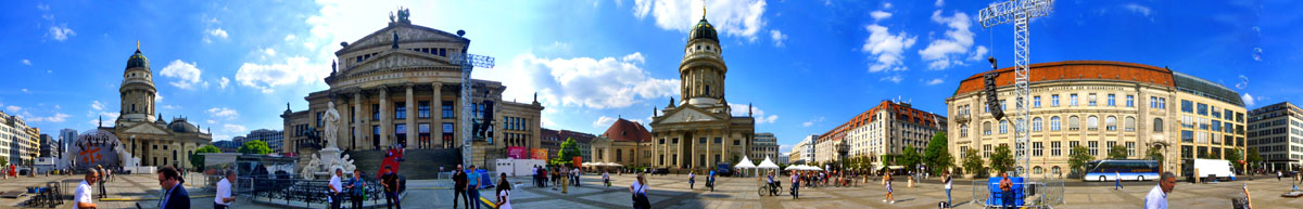
I think that the panoramic view of the square is impressive; you should see if you can locate Fred, who is looking right at the camera.
|
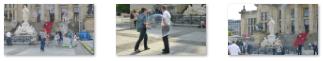
Interestingly, there was a group of people making soap bubbles- very large ones- from a point right beside the Schiller monument. I thought that they were worth photographing, and I took a few pictures, but none of mine turned out as well as Fred's did.
 (Click on Thumbnails to View) |
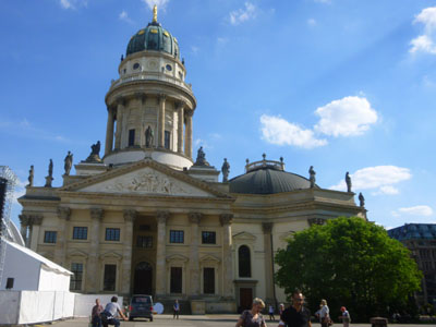
At the north end of the Gendarmenmarkt stands the French Church, and we went down there to get a closer look. At first we thought it was a matching building to the German Church, but the two were somewhat different.
|
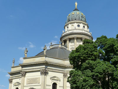
In 1785 Carl von Gontard modified the church and built next to it the domed tower, which, together with the French-speaking congregants, gave the church its name. The domed tower is technically not part of the church, there is no access between church and tower, and both buildings have different proprietors. It was built to embellish the Gendarmenmarkt ensemble at the instigation of Frederick the Great. The Deutscher Dom, however, on the other side of Gendarmenmarkt, consists of church building and tower as an entity.
In 1817 the French Church community, like most Prussian Calvinist, Reformed and Lutheran congregations joined the common umbrella organization named the Evangelical Church in Prussia (under this name since 1821), with each congregation maintaining its former denomination or adopting the new united denomination. The community of the "French Church of Friedrichstadt" maintained its Calvinist denomination.
The church eventually adapted to some Lutheran traditions: An organ was installed in 1753, competing with the Calvinist traditional of only singing without instrumental accompaniment. The singing of psalms was extended by hymns in 1791. The sober interior was refurbished in a more decorative but still Calvinist aniconistic style.
The Franz—sischer Dom was heavily damaged in World War II, then re-built from 1977 to 1981. Today it is not only used by its congregations, but also for conventions by the Evangelical Church in Germany- from the German Church at the opposite side of the square. The domed tower, which is a viewing platform open to visitors, provides a panoramic view of Berlin. A restaurant is located in the basement underneath the prayer hall. The tower also contains the Huguenot Museum of Berlin.
We were pretty worn out from the all-day tour, so we headed a bit southwest to the Stadtmitte U-Bahn stop, and this time took the subway back to the Zoo/Tiergarten stop near our hotel. When we came up aboveground, we were close to the fountain by Europa Center, and went right by one of the whimsical figures that are scattered around the fountain itself. Then we walked back to the Hotel Am Steinplatz. There, we found everyone else having drinks in the courtyard, so we joined them before going to the restaurant right next door for dinner.
You can use the links below to continue to another photo album page.
|
May 23, 2017: A Day on Museum Island |
|
May 21, 2017: A Walking Tour of Berlin |
|
Return to the Index for Our Visit to Berlin |