|
July 12, 1971: Oahu's Eastern Shore |
|
July 10, 1971: Arrival in Hawaii and Waikiki |
|
Return to the Index for My Visit to Hawaii |
Today I am going to make use of the car that the Cannons have lent me to make an excursion to the West and North Shores of Oahu, seeing the towns of Waianae and Haleiwa.
|
From Fort DeRussy, I found my way around Pearl Harbor and over to Nanakuli on the West Coast of the island. The prevailing winds coming to Hawaii usually come from the West or the North, and so the surfing is usually better on those sides of the island.
From Nanakuli, I intended to drive north through Waianae that then around Ka'ena Point to begin heading east along the north shore. The fly in the ointment is that Ka'ena Point is a State Park, and there is no road around the point that a normal car can navigate. This resulted in a change of plans.
I retraced my path all the way to Pearl Harbor to pick up State Road 99 that leads north through the center of Oahu to Haleiwa on the North Shore. From there, I drove a bit west, back towards Ka'ena Point (where the road again ended) and then I went back through Haleiwa eastward along the shore just to see what it was like.
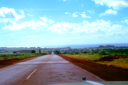
Finally, in late afternoon, I went back to Highway 99 to drive back down to Honolulu. On the way, I stopped at the Dole Pineapple Plantation Visitor Center to learn a bit about pineapple cultivation on the island and also to sample some pineapple fresh from the field.
Oahu's West Shore
|
|
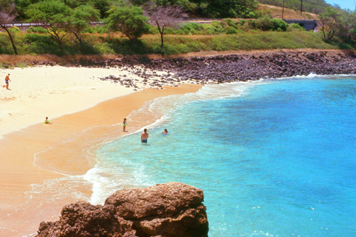
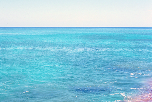
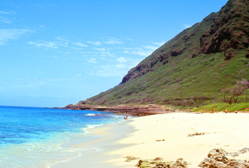
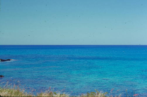
The water on this side of the island was even more incredibly beautiful than that at Waikiki- brilliant blues and greens. I understand that south of Kahe Point Beach Park there are lots of inlets and stuff along the coast, and it is a little less rocky. There is some development going on there, I understand, with a couple of resorts contemplated.
|
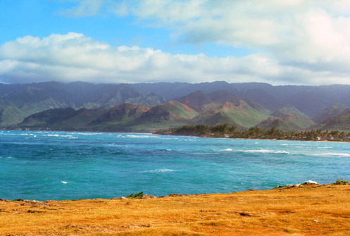
But the volcanic shoreline has a beauty all its own, and in many places the mountains of the Koolau Range come right down to the water. Notice again how blue the water actually is here in Hawaii.
The Hawaiian islands were formed by this volcanic activity initiated at an undersea magma source called the Hawaiʻi hotspot. The process is continuing to build islands; the tectonic plate beneath much of the Pacific Ocean continually moves northwest and the hot spot remains stationary, slowly creating new volcanoes. Because of the hotspot's location, all currently active land volcanoes are located on the southern half of the Big Island (Hawaii). The newest volcano, Lōʻihi Seamount, is located south of the coast of the Big Island.
The last volcanic eruption outside the Big Island occurred at Haleakalā on Maui before the late 18th century, possibly hundreds of years earlier. In 1790, Kīlauea exploded; it was the deadliest eruption known to have occurred in the modern era in what is now the United States. Volcanic activity and subsequent erosion have created impressive geological features; the second-highest point on any of the world's islands is on Hawaii.
Although there has not been an eruption on Oahu in recorded history, there has not been nearly enough time for the volcanic, rocky shores of most of Oahu to have weathered and eroded into beaches. The Leeward shore is at the very beginning of this process.
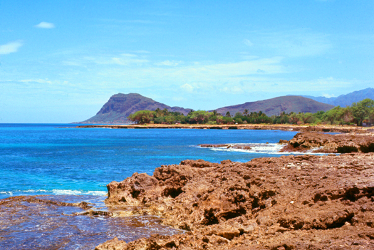
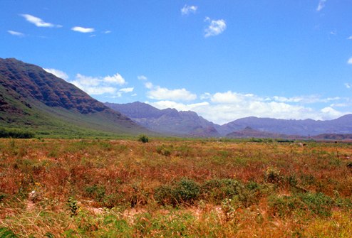
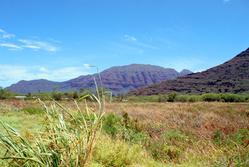
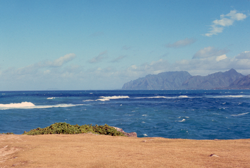
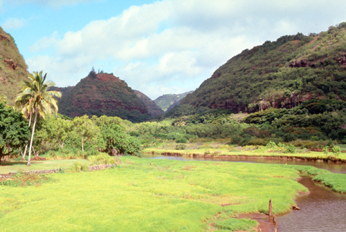
As I was driving slowly north along the shore, I was struck by the difference between the ocean on my left and the interior of the island on my right. At one point, where there was no development along the roadway, I stopped to take two pictures from the same spot- one looking landward and one out across the water:
|
|
The land in the foreground is suited for pineapple and sugar. The mountains that you are looking at are actually the tops of what are literally the highest mountains on earth, if you count height from the base of an individual mountain. Hawaii, of course, is like an iceberg, only the very top sticks up above the Pacific.
|
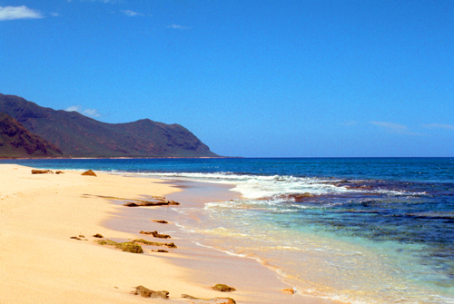
Waianae is the least crowded accommodation area on Oahu but it far less attractive than other places for a variety of reasons; and the coastal stretch to the north of the town up to Kaena Point is wild and remote. There are not long, continuous beaches as at Waikiki, but small ones in between rocky outcrops.
Most people who come to the Waianae region on this side of the island go south from the Farrington Highway to Koolina, which is quite a popular and safe area for tourists, with a wide range of water sports and activities and only a 30-minute drive from Waikiki. But, as I found out, the real beauty of this side of Oahu is found to the north, as this area is everything that Waikiki is not– untamed and largely unknown.
|
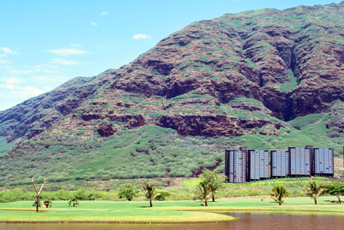
Perhaps you can tell what you are looking at, but even looking at it live I was perplexed. It took me a minute to realize (when I saw a car far down the road approaching the structure) that I was actually looking at a row of 15-storey apartments or condominiums that were well over a mile away from the highway.
I thought about driving over for a closer look, but down the road I could see a gate to this private development. There were no signs saying it was a resort or a hotel, so I assumed it was private residences.
But that led to more questions. Where do buildings of that size get their water? (It must be from wells.) And where does the water go once it is used? What about shopping? Waianae is close, but I didn't notice much in the way of shopping, so I guess that residents have to drive over near Pearl Harbor for most of what they need.
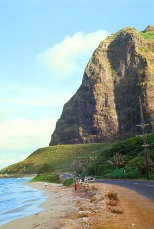
So why would anyone live way out here? The only answer would be the seclusion, which must be attraction enough to keep those buildings occupied. And the scenery is certaily spectacular. The Waianae mountains, formed about three million years ago and which stretch out of the picture to the right, feature the highest point on Oahu- Mt Kaala- at 4,017 feet.
|
But on the positive side, the climate along this coast is generally dry and sunny as the mountain range prevents wet weather from frequenting the area. Makaha Beach, north of Waianae, hosts an annual longboard contest. There are many pristine, white sand beaches that are top locations for fishing, snorkeling, and swimming, and provide great spots to watch the sunset over the ocean.
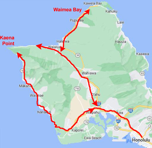
But as I drove north, there was less and less traffic and activity. The coastline does become quite rough with the surf unpredictable, and in some places, unsafe for swimming. But the real reason the area is lightly visited is that, as I found out, the highway does not continue around Kaena Point, which is what you are looking at in the picture at right. I had to stop and get out of the car to walk closer to what is Oahu’s westernmost location, although I did not go all the way to it.
Getting out of the car and walking for a bit was just what I needed. The weather was certainly nice and not too hot (in Hawaii there is usually a breeze, so even if the temperature is up towards 90° you don't feel it as much).
|
I also want to include one more picture that I took of the point, this one as I was driving back south to head back towards Honolulu. If you look closely, you can see the same cliff right at the point that you see in the picture at left.
|
So, having discovered that to get to the North Shore I would have find another way, I took a look at my tourist map and found that the best option was to go all the way back Pearl Harbor and then take Highway 99 up through the center of Oahu. Was I disappointed? Sure, but when you consider that Oahu is basically diamond-shaped and oriented north-south, and that each side of the diamond is roughly 25 miles, then you can see that retracing my path really only involved 30 miles or so- just an hour- to get back to Pearl, and then another 45 minutes through the center of the island to the North Shore.
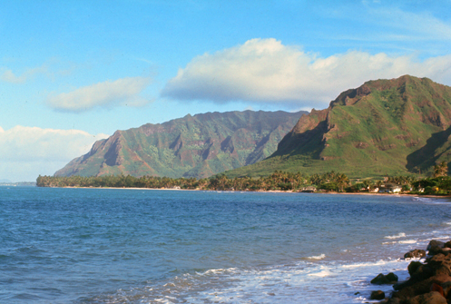
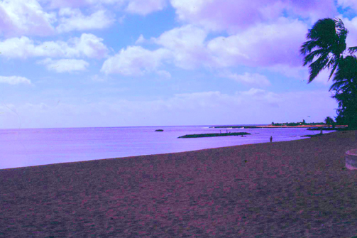
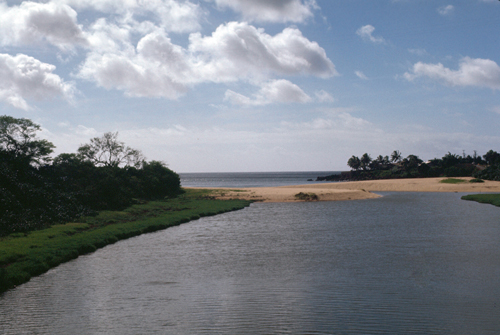
On the way back down the Leeward Coast, I took a couple more pictures, the last one as I stopped just before I headed back inland to Pearl Harbor, and took two more pictures looking north along the Leeward Coast:
|
|
Oahu's North Shore
|
The North Shore of Oahu encompasses the 17-mile north-facing coastal area between Ka’ena Point in the west and eastward to Kahuku Point. The North Shore is famous for its surfing, snorkeling, and of course the fifty-one beaches that stretch for more than 11 miles along this incredible expanse of Oahu coastline.
In 1898 a businessman named Benjamin Dillingham opened a hotel in the North Shore area and named it Haleʻiwa. In the Hawaiian language, hale means "house", and the ʻiwa is a frigatebird. He also built a railway line from Honolulu to Waialua along the west coast around Kaena Point, which opened the same year and ended in front of his hotel. The railroad inaugurated a passenger train, the Haleiwa Limited, which took two hours for this trip. This railroad was chartered as the Oahu Railway & Land Company.
Haleʻiwa is one of Oahu's most historic places, and the local government takes pains to try to ensure that new buildings adhere to a design plan that reflects the territorial architecture of Haleʻiwa's earlier sugar industry period. The town is home to 30 historic buildings featuring plantation architectural styles influenced by the Waialua Sugar Co.
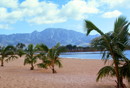
The Haleʻiwa community of a couple thousand people is located on Waialua Bay, at the mouth of Anahulu Stream (also known as Anahulu River). A small boat harbor is located here, and the shore of the bay is surrounded by Haleʻiwa Beach Park (north side) and Haleʻiwa Aliʻi Beach Park (south side). Further west from the center of town is Kaiaka State Recreation Area on Kiaka Point beside Kaiaka Bay. Its old plantation town character is preserved in many of the buildings, making this a popular destination for tourists and residents alike who are visiting surfing and diving sites along the north shore.
|
I first drove through Waialua and headed west to see how close I could get, once again, to Kaena Point. I found myself driving through Mokuleia Beach Park, which seemed to have a very nice beach and there were quite a few people around. At the west end of the park the road again ended, and from this point the only way to get to Kaena Point (seen in the distance in the picture at right) is via a fairly level hiking trail.
So you can actually drive around almost all of Oahu, but if you want to circumnavigate the island, you will have to include a five mile hiking trail. (I did read later about one tour that does exactly that. It begins in Waikiki and drives you up the east side of Oahu, around Kahuku Point in the northeast, and then all the way across the North Shore to let you out right where I stopped. Then the tour group hikes the five-mile trail, and by the time they get around to the Leeward side of the island, their vehicle has gone around to meet them (or perhaps a second vehicle is waiting there to pick them up to continue the tour).
I was struck by the fact that anyplace else this beach would probably be overbuilt and teeming with people, but Hawaii is just beginning to be "discovered" by great crowds of people, and I imagine that in twenty years or so there will be lots of activity here. Anyway, I got back in the car and now headed east along the North Shore. The road stayed quite close to the ocean, save for a detour inland through Haleiwa.
|
After the first American Protestant missionaries arrived in 1820, they began establishing stations in the rural areas of O’ahu. The first of these was the Waialua Station, opened in 1832 on the bank of Anahulu Stream where the Emerson faily did missionary work until 1864, when Emerson retired. On his retirement, another missionary, Orramel Gulick was appointed to succeed him. Gulick moved to Waialua in 1865 and in additional to his pastoral duties, established a school for girls on Anahulu Stream that continued until 1881. The natives called the school "Hale Iwa".
In 1899 the Hale’iwa Hotel opened near the mouth of Anahulu Stream. Built as a resort on the O.R.&L. train line, its first manager was Curtis P. Iaukea, who had served as royal chamberlain to King Kalakaua at ‘Iolani Palace. During the height of its popularity, the hotel made the name Hale’iwa famous, and when its doors closed in 1943, the name Hale’iwa remained as the name of the surrounding community.
Hale’iwa Beach Park was dedicated in 1939 as Waialua Beach Park, but the community requested that the name be changed to Hale’iwa. Their request was approved in 1948. Hale’iwa literally means “house [of the] frigate bird,” but the name also has a poetic meaning, “beautiful home.” Frigate birds in flight are a symbol of beauty as they glide high above the ocean. Hale’iwa Beach Park is fronted by a narrow sand beach. While its shallow, rocky ocean bottom does not attract many swimmers, the park is well-used by canoe paddlers as a training and regatta site, by kayakers as an access point to the bay, and by surfers who ride the waves at Pua’ena Point.
I took two other pictures between Hale'iwa Beach Park and my next stop, Waimea Beach Park, one of the ocean off the North Shore and another just as I was coming to Waimea.
|
|
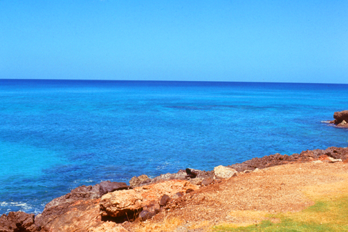
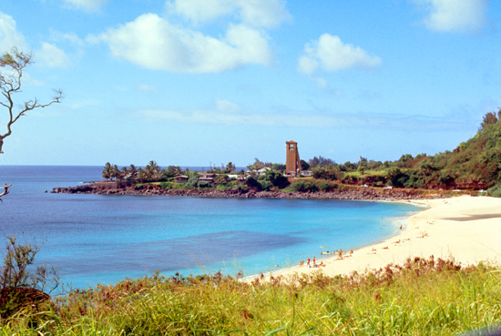
And then, just a short ways further on, I came to Waimea Beach Park.
|
In winter, Waimea and other North Shore locations such as Pipeline and Sunset Beach host a number of surfing contests because of the large waves found here. These waves are created by winter storms in the North Pacific, and their arrival on O'ahu's North Shore are typically forecast accurately several days in advance. In summer, Waimea typically has clear and calm water- as you see today.
The surf break at Waimea Bay was significant in the development of Big wave surfing. Larger surf at the bay went unridden for years until Fall, 1957, when a handful of surfers finally paddled out and rode the giant waves that break off the northern point of the bay. While the surf only breaks big several times a year, Waimea was the most prestigious big wave surf break in the world for decades, and even though better sites have been found, Waimea still holds a significant place in big-wave surfing. I first heard of Waimea in the Beach Boys 1964 song, Surfin' U.S.A..
But it's summer now, and so conditions are quite calm, and visitors to the park, like me, are swimming or simply strolling along the sand. But if you're a daredevil, come back in the winter for the 40-foot waves.
|
|
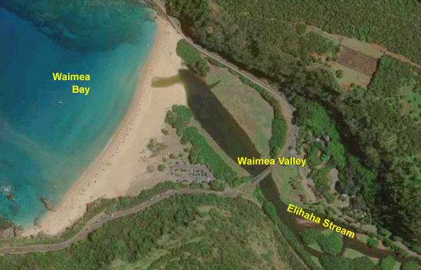
I got out of the car and walked around a bit, but I would have stayed longer had I known there was hike to the Waimea Falls, a 45-foot waterfall. As well as being a popular tourist attraction, many folks also utilize the beautiful grounds for concerts, parties, weddings, special events, and even a weekly farmers market.
|
Waimea Valley was considered one of the more recognized locations for its spiritual significance. Ancient Hawaiians were thought to partake in various indigenous religious activities, like human sacrifice. O’ahu’s largest heiau, or temple, resides here, overlooking the valley.
In 1092 Waimea Valley was given to the high priests or the Kahuna Nui. It eventually became the home of one of the most distinguished priesthoods in the islands, the Pa'ao. Kamehameha the Great's exclusive Kahuna, Hewahewa, was a descendant of the Pa'ao. The Kahuna Nui were essential to Hawaiian society because they were the experts in various fields like farming, healing, spiritual guidance, fishing, and teaching both the Ali’i and the common people. Over the course of time, Waimea became known as “the valley of the priests”.
While I drove a little further along the North Shore, I wanted to save Kahuku Point as the end location for an investigation of the windward side (east side) of the island. So at Sunset Beach, I turned to head back to Haleiwa and then to highway 99 back down through the center of the island and back to Honolulu.
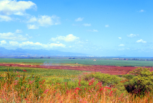
Pineapple Production on Oahu
|
The pineapple, believed to have its origins in Paraguay or Brazil, was loaded on trade ships and taken to distant places like China, India, Australia, and Mexico in the 15th and 16th centuries. It is believed that the pineapple first arrived on the Big Island of Hawaii in 1527. It began to be cultivated at that time, although such cultivation did not become widespread for centuries as demand grew slowly. By the turn of the nineteenth century, however, there were very large fields of both pineapple and sugar cane on at least three of the largest Hawaiian islands.
As a result of a growing demand pineapple and, most particularly, for sugar cane, the demand for labor on the various Hawaiian plantations grew as well. There were not nearly enough native Hawaiians who cared to (or who were, in some situations, almost forced to) work in this labor-intensive industry, and so the mass import of foreign workers started in the 1850s. These workers came from China, Japan, the Philippines, Korea, Germany, Portugal, Norway, Spain, Scotland, Puerto Rico and Russia.
But still, cultivation of pineapple was much less important, and much less lucrative, than was the production of sugar cane. But this was about to change.
|
In 1922, Dole bought the island of Lanai. How a private individual came to own the entire island is a story in itself, but the first recorded "sale" of the island had occurred only a dozen years earlier, when the U.S. Supreme Court validated the sale of the island from one Charles Gay to a William Irwin for the vast sum of $1. Gay planted the very first pineapple on the island in 1921 and Dole, then president of the Hawaiian Pineapple Company (later to be renamed Dole Food Company) bought it to establish the largest pineapple plantation in the world, growing 75 percent, in its peak years, of the world supply. Dole passed away in 1958. Today, his Hawaiian Pineapple Company is still known worldwide as the Dole Food Company.
For immigrant workers, life on the plantation was hard. The work day usually started at 6 in the morning and ended at 4:30 in the afternoon. While in the fields, the workers had to wear heavy protective clothing because of the sharp pineapple leaves. Even though the work was physically demanding, the wages were less than $20 a month. However, housing near the fields was free. Pineapple production spread quickly to Oahu and the Big Island, with Dole establishing large plantations on both islands.
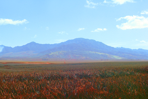
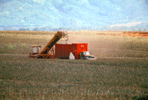
Pineapple in Hawaii are grown year-round. Each field has to be prepared before one can start planting the fruits. Preparation includes fumigating the soil and placing black plastic mulch in the ground. The mulch helps to retain the moisture, confine the fumigant, control weeds and pests, and store heat for a better root growth. Even today, every single pineapple is planted by hand. This is done by digging a hole through the plastic mulch and placing the crown of the fruit, the green leaves, into it. A skilled planter can plant about 10,000 fruits a day.
|
A ripe pineapple is one that has green leaves and a firm body. A large pineapple doesn't mean that it is riper or better tasting. Also, the color of the outer shell doesn't indicate the state of ripeness, for even a pineapple that is green outside can be ripe inside. A pineapple won't become sweeter or riper after being picked. Therefore, it is best to eat a pineapple as soon as possible after its purchase. If you plan to store it for a few days, it is best to keep it in the refrigerator to preserve its freshness. Almost every restaurant on Oahu seems to have fresh pineapple on the menu, and I confess that it is nothing like the canned variety.
At present, Hawaiian pineapple plantations produce almost a two-thirds of the world's crop and supply about 80 percent of canned pineapple products. Moreover, Hawaii's agricultural industry, including pineapple, sugar cane, other tropical fruits and flowers, plays an important part in the state's economy, providing more than 75,000 jobs and generating billions of dollars annually. There are, however, clouds on the horizon. Labor in Hawaii is relatively expensive, and pineapple production has begun to increase in Central America, Indonesia, and the Philippines. With shipping costs on the decline, these areas may well expand significantly in the future.
I got most of this history at the Dole Fruit Stand, a long, low, wooden building near the highway at the edge of one of the pineapple fields. It was air-conditioned (which was nice) and offered little 15-minute guided tours over to the edge of the field so you could see the actual plants and have the planting and harvesting process explained. Inside, you could actually buy pineapple and many of Dole's products. Best of all, there were huge bowls of fresh pineapple and a large supply of toothpicks- and a worker expertly peeling, coring, and cutting the fruit fresh from the field.
Note from 2022:
In investigating the current state of pineapple production for this webpage I have learned that the rustic fruit stand is long gone, replaced by the "Dole Pineapple Experience" in 1989. Today, the "Experience" is one of Oahu's most popular visitor attractions and welcomes more than one million visitors a year. There is the Pineapple Express Train Tour, the Plantation Garden Tour, and the Pineapple Garden Maze. Also popular are informational displays and presentations, as well as our plantation country store offering a wide variety of Dole Plantation gifts, local favorites, foods and refreshments including the world-famous DoleWhip®. And, before you leave you can purchase fresh pineapple to take home.
It has been a full day, and tomorrow I plan on completing my circumnavigation of Oahu by going over to the much more populous Windward side of the island.
You can use the links below to continue to another photo album page.
You can use the links below to continue to another photo album page.
|
July 12, 1971: Oahu's Eastern Shore |
|
July 10, 1971: Arrival in Hawaii and Waikiki |
|
Return to the Index for My Visit to Hawaii |