|
October 26, 1996: Hiking in Big Bend - 2 |
|
October 24, 1996: The Area Around Fort Davis |
|
Return to the Index for Our Big Bend Trip |
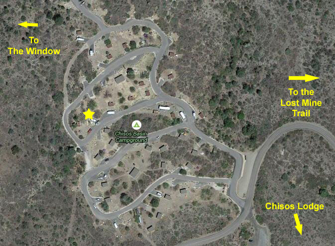
Our Campsite in the Chisos Basin
|
The Chisos Basin is also the site of the Big Bend's lodge- the Chisos Lodge. This building is a hotel-like affair for those who want to stay in the park but not camp. As with most National Park Lodges, staying in the Chisos Lodge is pricey, but other than roughing it, the next nearest motel is an hour away at least.
Last night, after we'd gotten settled and had our dinner, we spread out our maps to decide what we wanted to do today- our first day of hiking here in the park.
Hiking the Lost Mine Trail
 |
Of the many romantic legends which abound throughout the West, few match the Lost Mine Story from which the peak takes its name. Is it true? Did the mine exist? Or was it a campfire fabrication handed down from generation to generation?
|
The early Spanish explorers of the Southwest were more single-minded, though. According to legend, a rich ore body was discovered on the highest point of Lost Mine Peak. Life-term prisoners were forced to work the mine. These men were blindfolded on several occasions in their march from the Presidio in San Vicente, Mexico, to prevent them from learning its location. The ruins of this presidio may still be observed some 20 miles southwest of the peak across the Rio Grande in Mexico.
A story related how the fierce Commanche Indians, who resented the Spaniards' invasion of their homeland and hunting grounds, attacked and killed them to the last man. The last act, so goes the story, was to seal the mine entrance to prevent further exploitation. Legend says that if a person stands in the chapel door of San Vicente's mission on Easter morning, he can watch the sun's first rays strike Lost Mine Peak at the exact mine entrance.
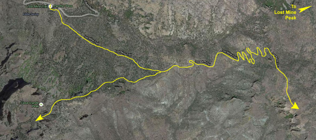
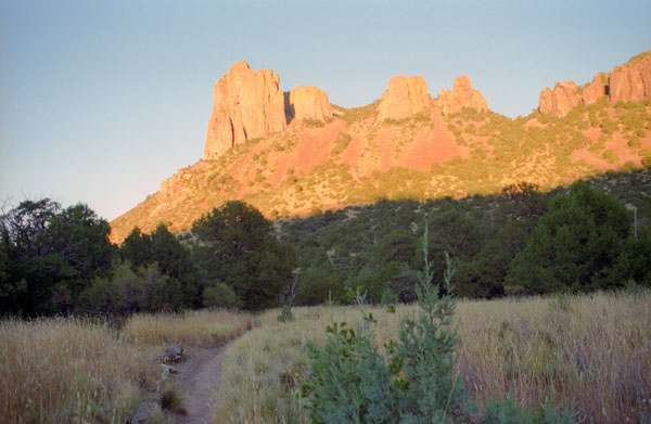
The Lost Mine Trail is by no means a trivial hike; on the hike to the lookout and back to Casa Grande, we covered about five miles and ascended (and descended) about 1,000 feet. From the trailhead, we gained altitude immediately- although most of the height gain is later on, in the switchbacks. The earlier portions of the hike include dense coverage of Pinyon Pine and other trees.
On our right as we climbed, we had good views of Casa Grande, but we'll be back to it in a few hours. After about a mile, we came up onto the ridgeline that connects Casa Grande and Lost Mine Peak. We'll turn left, now, and continue to the Lost Mine Peak Lookout.
|
The delicate balance of Big Bend's ecosystems is apparent along this ridge; we could see the fine line between desert shrub and forest in the Big Bend. As we walked generally east, the south side of the ridge was relatively sparse shrub land is in contrast with the thicker forested slope of the north side. Since the north gets less direct sunlight, slightly cooler temperatures and better moisture retention Pinyon Pines and other plant species with similar requirements can thrive.
I must say that it looked inviting to light out cross-country to at least get to the base of Lost Mine Peak, and I had no doubt that there would be a way up higher than that. But trying to work that in to what will already be an all-day hike would be impossible. Maybe next time.
After another half-mile along the ridgeline, the terrain got steeper, particularly once we came to the switchbacks. We'd been up these switchbacks before, and it is a really neat hike, although you are mostly in thin forest with not-so-spectacular views until you get up to the top.
At one point, we thought we saw a rattlesnake on a rock off to our right. I'm not sure that's what it was, since I didn't hear any rattling, but since we didn't get closer than fifteen feet to it, perhaps it saw no need to warn us off. I was curious as to how prevalent these snakes are, and I asked a ranger later about the snakes and whether they caused problems for hikers. The answer was a pretty convincing no.
|
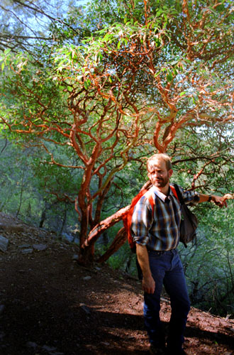
Along the switchbacks, Fred came across these interesting trees (see picture at left). The trail guide didn’t tell us exactly what these trees were, with their reddish bark and few leaves, but we first thought it could have been one of the many varieties of oaks that grow here. Closer inspection, though, convinced us that it was more likely a Skunkbush Sumac, a shrub that grows all over the place here. Birds eat the fruit, and the Indians made much use of the shrub. They brewed a cooling drink with the fruits and wove baskets with the slender twigs. They also produced a yellow dye from the bark. Skunkbush Sumac is closely related to poison ivy, but is not itself poisonous.
After the switchbacks stop the trail continued up a relatively gentle slope to what appears to be the lookout point, but we remembered from our earlier trip that the actual lookout was just a bit further on and only slightly higher, so we headed on out there, along the ridge- now relatively treeless.
We got there, and the views were as beautiful as we remembered them. This time, though, we'll wait and photograph the views from the trail to Casa Grande that we haven't been on. We relaxed here for twenty minutes or so, but it was actually getting chilly even in the bright sunlight, so we returned down the trail to the fork and the trail to Casa Grande.
Hiking to the Top of Casa Grande
|
The mountain is roughly a square in shape with rhyolite cliffs and flat topped summit that does follow an east-west ridgeline. Prickly pear cacti are the dominant species on the summit plateau, with more variety in the valleys, but dominated by juniper trees. Erosion has created plenty of passages up to the summit with some rock scrambling or easy climbing move being the crux of the climb.
Casa Grande is popular with rock climbers, and at the northwest corner of the peak there are some relatively easy (for experienced rock climbers, anyway) routes to the top. But following even that easy route requires experience and some equipment, and is well outside our comfort zone.
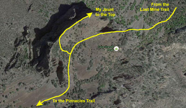
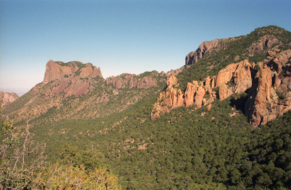
As we headed down the ridgeline from the Lost Mine Trail saddle junction, we got great views to the northwest of the Chisos Mountains:
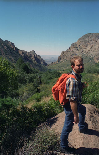
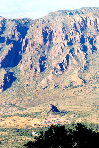 The Basin |
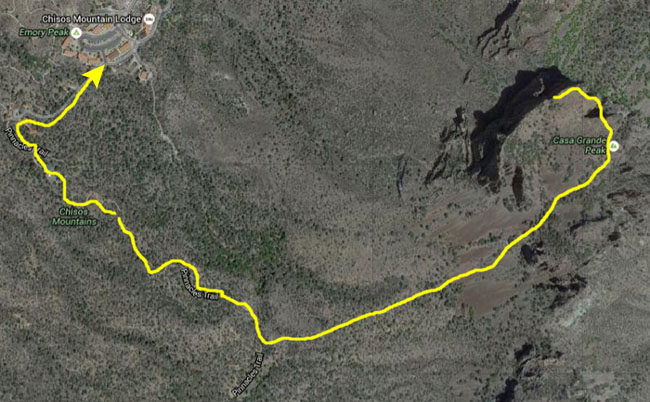
(Picture at left) This view is from the Casa Grande trail, and you can see the Chisos Mountain Lodge and camping area. We are getting some spectacular views. This is a trail we’ve not been on, and at least I intend to get to the top of Casa Grande. I’ve always found that small, isolated peak in the middle of the Chisos Mountains valley very odd- almost as if something had been dropped into mud- but it's probably just an outcropping of harder rock. I’d like to climb those mountains across the valley sometime.
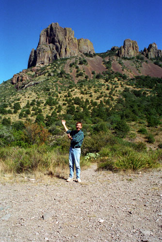
(Picture at right)
|
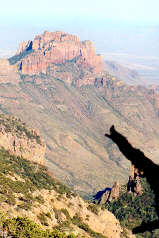 The Chisos Mountains |
Even the walk the half mile from the trail junction over to the base of Casa Grande was really neat; there were wonderful views in all directions.
|
About 125 million years ago, the park area was beneath a vast inland sea. The sediments of silt, sand, and seashells became compacted and hardened into layers of sandstone and limestone. These were later elevated above sea level by the tremendous stresses and pressures which occur within the earth’s crust. Slowly, over millions of years, this vast surface fractured into great blocks. Some of these were elevated into mountains and ridges, while low blocks in between became valleys.
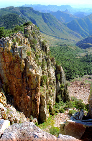
We were walking generally west towards the south base of Casa Grande; the park road was on our right, hidden down below the ridge, and Juniper Canyon was to our left. We got beautiful views of it:
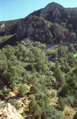 Juniper Canyon |
(Picture at left) Here is a view looking down the slope into Juniper Canyon, taken from the Casa Grande Trail.
(Picture at right)
|
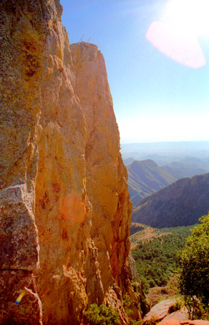 Cliff Face at Casa Grande |
We have come now to the closest point on the Casa Grande Trail to Casa Grande, and we are about as high as Fred is willing to go. To get to the top, there is not a marked trail; you just have to follow the paths left by others who have made the ascent. Fred has elected to remain down on the trail while I climb on up to the top of the peak- another couple hundred feet or so up. We’ve had experiences where I’ve gone off on my own before, most notably on our summer trip earlier this year when Fred got poked in the eye by a cactus, and I got pierced in my heel by one as well. So this time we’ve coordinated our signals so he doesn’t get worried and we stay in some sort of touch with each other.
I did indeed scramble up the rocks to the top of the peak; it was neither difficult nor dangerous, and I debated going back down to entice Fred to come on up, but I just shouted down to him that all was well. Here are the first two views from the peak:
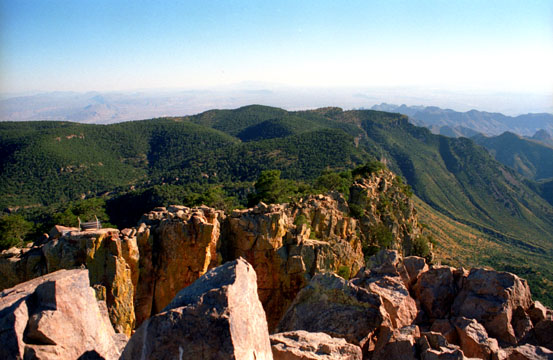 This is the Chisos Mountains valley, Lodge and camping area, taken from the top of Casa Grande. The views from here are spectacular, as this shot evidences. We are looking basically west here, but due to the fact that the Rio Grande bends here, we are actually looking into Mexico, beyond the mountains. |
 This view looks eastward along the Chisos Mountains ridge line from the top of Casa Grande. This whole area is spectacularly beautiful (but just one of many such spectacularly beautiful sights we have seen on our hikes in the last five years). |
Knowing that this was one place I would probably never be again, I thought I would take quite a few pictures, and I was glad I had not repeated pictures from over at the Lost Mine Trail lookout. Here are some of those pictures:
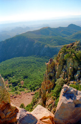 Looking Southeast |
(Picture at left) Here we are looking into Juniper Canyon, and most of the greenery that you can see here is juniper, of one variety or another. While this whole area of Texas is basically desert, when you get high enough, the juniper (and other trees) grow plentifully. These rocky cliffs are certainly inviting, but even I’m not foolhardy enough to try to climb up or down them without equipment to keep me from falling.
(Picture at right)
|
 Northeast Towards Lost Mine Peak |
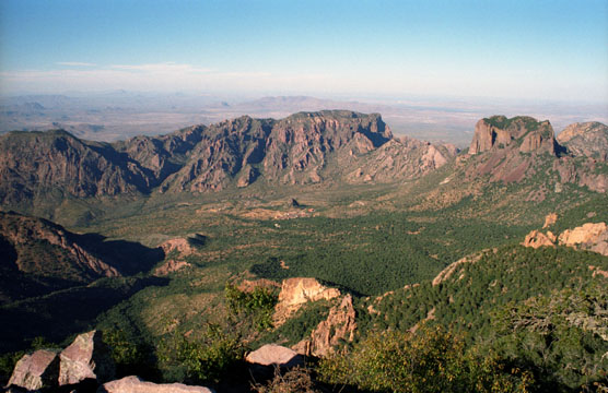 This is the Basin. In the center of the picture is that small, isolated peak that I’ve mentioned before. The Lodge and camping area are just this side of it. Santa Elena Canyon is beyond the peaks in the center of the picture, and in the distance is Mexico. I took another similar view and you can see it here. |
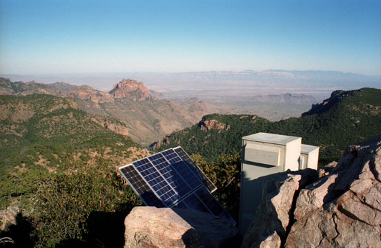 This view looks eastward past some communications equipment and across the West Texas desert to the Rosillos Mountains in the distance. The solar panels provide power to whatever is in the boxes. The Lost Mine Trail is beyond the boxes and down, and then turns left and continues down to the road (from this perspective). |
I don't usually plan ahead much sometimes, but today I had the foresight to ask Fred to let me bring the tripod up with me on my ascent. I thought that using the tripod would be a lot better than just trying to set the camera on a rock or something.
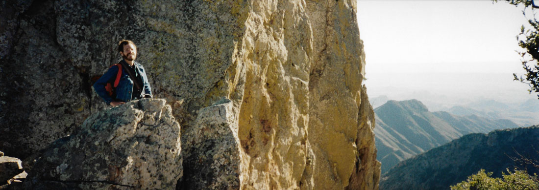
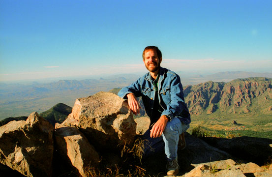 Here I am on top of Casa Grande, in Big Bend National Park. The campground and Lodge are at the right and Mexico is off in the distance. And, yes, it’s chilly enough up here for the jacket. |
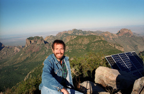 Here is a different view of me at the top of Casa Grande. The valley with the Lodge and camping area is at the left, and the park entrance is to the right. Once again, Mexico is in the distance. |
I took one other picture of myself here at the top of Casa Grande; it looks southeast along the ridge line between Casa Grande and Lost Mine Peak. You can see that picture here.
On the Pinnacles Trail
|
From Casa Grande, though, we followed a path that had apparently been blazed by other hikers frequently to work our way west until we came out onto that trail. When we came onto the pinnacles Trail, we were about a mile and a half south of the Chisos Basin trailhead. another couple of miles south of us the trail branches off to Emory Peak, but we did not have time to do that hike today. (We often save one or two hikes for a return visit, and this would be one that we would bank for later.)
So instead of going south, we turned to our right to follow the Pinnacles Trail down into the Chisos Basin.
|
 |
The guidebook has warned that there have been a number of bear sightings recently, and we are on the lookout for brown bears. The fact that Mexican black bears are back in Big Bend National Park is a surprise to many visitors. A small population of them has reestablished itself in the Chisos Mountains since 1989 after an absence of over forty years. In the few months prior to our being there, rangers took over 100 written reports of black bears, most near Boot Canyon and Emory Peak, but others on the Lost Mine Trail and even down into the Basin- just along the trail we are on. We think we saw one off the trail, but we couldn't be sure.
Walking Down to the Window
|
We went ahead and walked down to The Window. The early evening light was dim, but when we got to The Window, we would be able to utilize the sunlight coming through the notch in the mountains. At The Window, Fred first took a panoramic picture that looks beyond me and out the rock window towards Mexico:
 |
And then, while he stayed down at a safe observation point, I climbed up above him so he could get this picture:
 |
Then, with almost all our light gone, we went back to the campsite, where Fred did his usual wonders over the camp stove, and we had a hot meal that night. The campground was full, as it usually is, but it gets very quiet late at night.
After a good night’s sleep, we will be do some different hikes on Saturday in the desert area on the northwest side of the mountains ringing the Basin, and we will also visit Santa Elena Canyon- where the Rio Grande flows.
You can use the links below to continue to another photo album page.
|
October 26, 1996: Hiking in Big Bend - 2 |
|
October 24, 1996: The Area Around Fort Davis |
|
Return to the Index for Our Big Bend Trip |