|
May 18, 1999: A Visit With Jack Fontaine in NH |
|
May 8, 1999: Ron and Lowery Leave for Florida |
|
Return to the Index for 1999 |
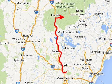
Working with DRT, Inc., I had a business trip to Concord, New Hampshire for the two weeks from May 10 through May 21. As part of our consulting agreements with clients, I was allowed the funds to go home to Dallas over the intervening weekend, May 15-16. Since I had the funds, though, instead of using them to return to Dallas, I instead used them to bring Fred to New Hampshire for the weekend. He had never been to New England before, so this would be something different for him.
|
I was at the Red Roof Inn just a block south of the Paymentech building and just east of I-93. We had been talking about things to do and see in the weeks before Fred came up, so we got to sleep right away, intending to do as much as we could on Saturday and Sunday.
We had some breakfast at the hotel before heading north on I-93 to our first stop- the Flume at Franconia Notch State Park.
The Flume Gorge Hike
|
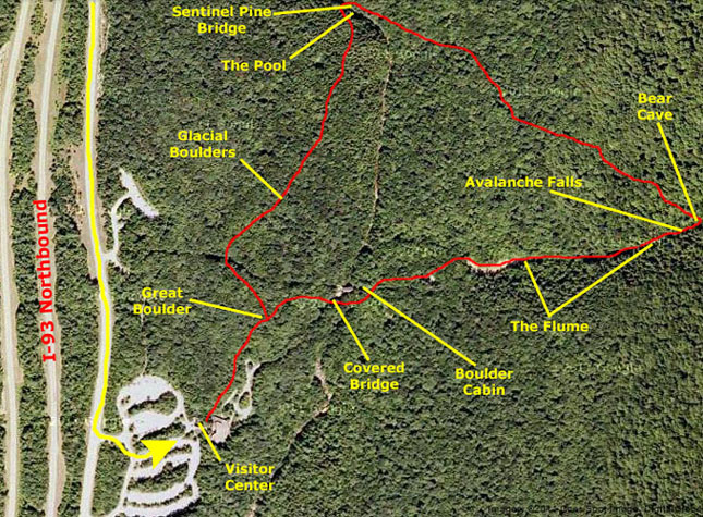
Before we head off on the hike, though, let's take a look at the area we will be hiking through. In this photo album, I am fond of using aerial views to give you a sense of what a place was like, and I wanted to do so here, as well. (Aerial views were not available in 1999, but I am doing this particular page in 2014, when they are.) When I looked at the aerial view of the area, though, it was very hard to pick out any of the details of the hike. Actually, the area is so forested, that I really didn't expect to even see the trail, but I thought that one of the covered bridges, and the flume itself, which are open to the sky and not hidden underneath the tree canopy would be visible.
But they really weren's all that visible. It's not that you can't see them from orbit, but I have found that once you get very far outside urban areas, the resolution of the aerial views that are available is nothing like what you can get in major urban areas. I guess it is just not cost-effective for anyone to survey the wide open spaces with the detail that they do the places most people go.
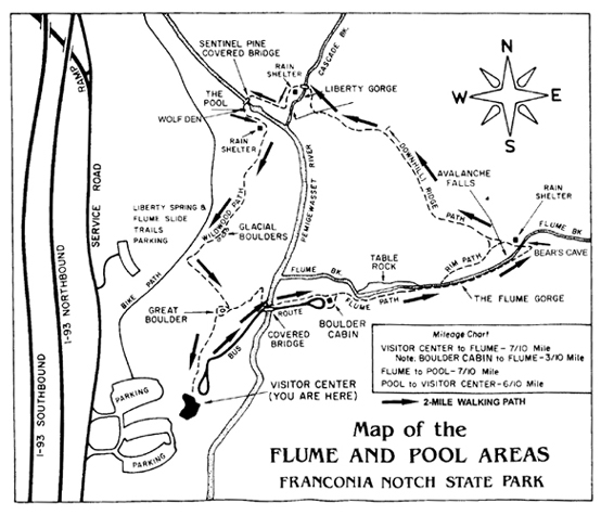
Still, I thought the aerial view would be interesting, so I have included it below, marked to show the route we followed and the places we stopped (even if we didn't take any pictures of them). Just for your information, I have put beside the aerial view a copy of the trail diagram that we got in the trail guide that we picked up in the visitor center:
 |
 |
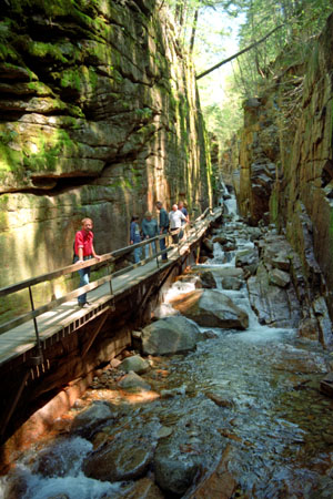
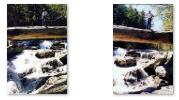
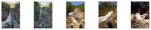
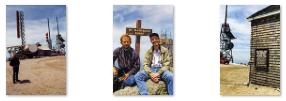
The Flume is a natural gorge extending 800 feet at the base of Mount Liberty. The walls of Conway granite rise to a height of 70 to 90 feet and are 12 to 20 feet apart. A trip into the Flume begins and ends at the Flume Visitor's Center. Guests can choose to walk through just the Gorge or do a two mile loop. The walk includes uphill walking and lots of stairs. The boardwalk allows one to look closely at the growth of flowers, ferns and mosses found here.
We walked through the Visitor Center to the trailhead. The first part of the hike took us from the Visitor Center to a covered bridge. This picturesque covered bridge is one of the oldest in the state. It was built in the 1886 and has been restored several times. Such bridges were often called �kissing bridges� because of the darkness and privacy they provided. This bridge was built across the scenic Pemigewasset River. Pemigewasset means �swift or rapid current� in the Abenaki Indian language.
|
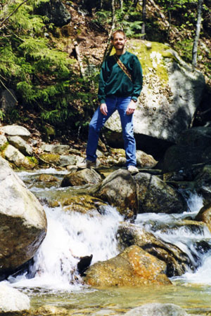
From the covered bridge we continued up the trail through the shady woods that bordered Flume Brook. Fred, of course, was interested in some of the forest flora that we passed. (He even snapped a picture of some of the forest fauna that we encountered.) Along the trail, we also passed some little rivulets that brought more water into Flume Brook, and one of them had a particularly nice little waterfall.
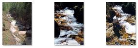
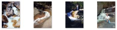
Click on the thumbnail images below to see some other views of Flume Brook as it looks below the gorge:
 |
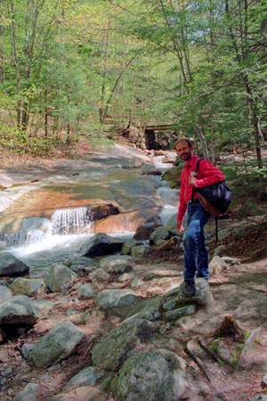
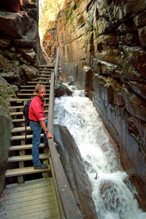
Soon, we came to the beginning of the boardwalk and stairway system that led into the actual Flume gorge. At the lower end of the Flume Gorge was perhaps the nicest waterfall we would see all day. It was particularly neat in that it was easy to climb around next to it, and of course, I did so. crossing a little footbridge over to the far side of the brook, scrambling up beside the waterfall. From here, I could see back down to the boardwalk that leads into the flume gorge. I thought it was nice that this pretty waterfall was so accessible; even people who weren't going to do the whole circular walk that we were could get to this spot to view it. Fred also crossed the bridge, although he didn't come up as high as I was. He did, however, take a picture of me beside the waterfall.
|
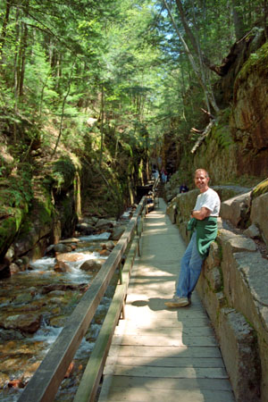
The pictures at right will show you exactly what we saw. It was really quite amazing- not just the natural wonder of the Flume Gorge, but also the effort that those who constructed the walkways and stairs. I suppose that the canyon was about a quarter mile long, and the stairs and walkway ascended continually all the way to the end of the canyon, which narrowed and got more shallow as we proceeded.
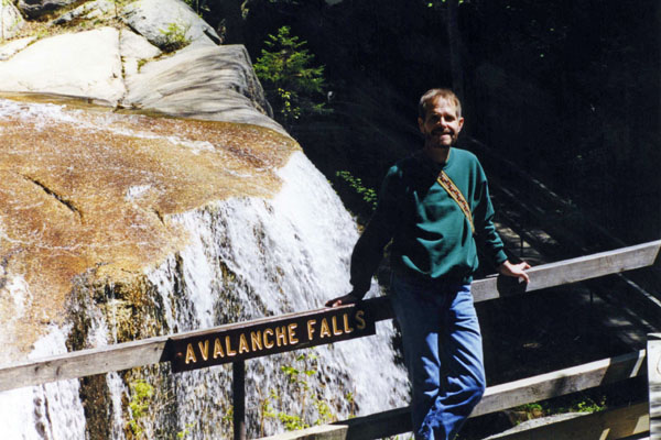
As we got to the end of the canyon, we could see Avalanche Falls ahead of us. At this point, the stairway climbed up to a footbridge that took us over the brook to the west (the boardwalk had switched to the other side of the canyon towards the head of it).
|
At Bear Cave, the trail turned northwest, and we got our last view of Flume Brook coming down from the hillside above us, and forming a very nice waterfall. From that point, the trail became a forest walk as it wandered northwest and sloped downward to the point where we would cross another of one of the many streams that flow through the White Mountains.
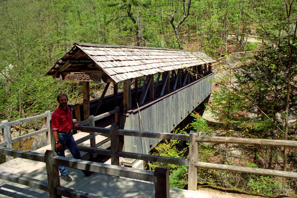
The forest walk had its own attractions, although it is always nice to be walking along flowing water. After about a half mile, we came to an overlook where we could see the Sentinel Pine covered bridge that crosses a second stream. The trail came down to the east end of the covered bridge, and we crossed it to get to the west side of the stream that it crossed.
|
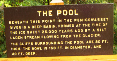 |
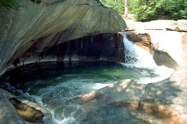
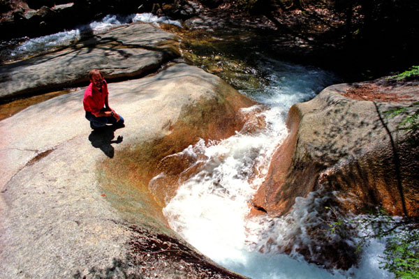
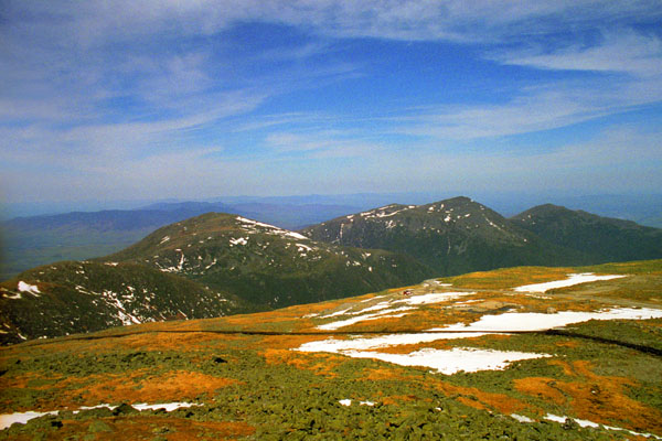
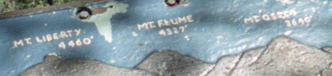
The Pool is a deep basin in the Pemigewasset River. It was formed at the end of the Ice Age, 14,000 years ago, by a silt-laden stream flowing from the glacier. The Pool is 40 feet deep and 150 feet in diameter, and is surrounded by cliffs 130 feet high. A cascade rushes into it over fragments of granite that have fallen from the cliffs above. Once again, the path descended through the woods and along the low cliff beside the stream (from which the previous picture was taken. There were also great views of the White Mountains. In case you are curious, here is a closeup of the portion of the sign I am leaning on that will identify the mountains in the picture:
 |
We followed the trail back to the Visitor Center, passing a number of large glacial boulders that littered the forest. At the Center, we stopped to have some lunch before leaving the Flume and heading off to see something else.
The Basin
|
Franconia Notch State Park is located in the White Mountains and straddles 8 miles of Interstate 93 as it passes through Franconia Notch, a mountain pass between the Kinsman Range and Franconia Range. In addition to the attractions listed above, there is fishing in Echo Lake and Profile Lake, and miles of hiking, biking and ski trails.
When we parked and walked through the tunnel underneath the Interstate to The Basin, we found ourselves beside the Pemigewasset River again. The Basin, which is about four feet deep and 20 feet across, was scrubbed out by stones dragged (and eventually deposited) by the retreating North American ice sheet, and since made smooth by 15 millennia of rapidly whirling pebbles and grit.
Below the Basin is "Old Man's Foot", a distinctively shaped rock formation, also the natural result of Pemigewasset's erosive energy.
|
Click on the thumbnail images below to see some other pictures taken here at The Basin:
|
As a matter of fact, I recall that there was only one sign cautioning that rocks can be wet and slippery, but I suppose that because there was no high fall or other sharp drop-off, Park officials have left it to parents to watch their kids and adults to watch themselves. We did not see anyone in The Basin, but I have read that it can be a popular, if somewhat turbulent, place for the young and reckless to swim. For our part, we enjoyed walking around here immensely.
The Cascades and Kinsman Falls
|
|
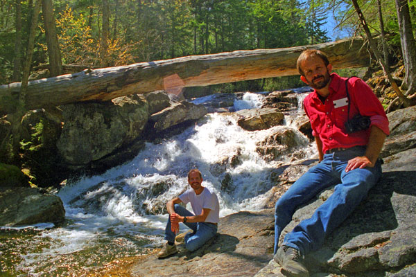
From The Cascades we continued further along the trail to Kinsman Falls; it was an easy hike along the river. There was a sign when we arrived at Kinsman Falls, we found ourselves at a large pool with the waterfall on the far side.
We spent, I suppose, more than an hour on this hike along the river, and it was very, very pleasant. Eventually, we headed back to the car to continue north through Franconia Notch.
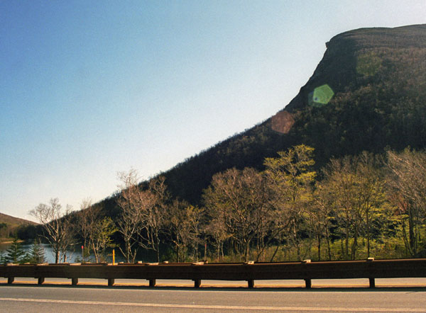
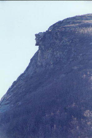
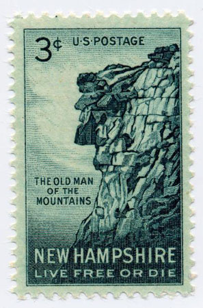
The Old Man in the Mountain
|
The formation was carved by glaciers and was first recorded as being discovered by a surveying team around 1805. The official state history says several groups of surveyors were working in the Franconia Notch area at the time and claimed credit for the discovery.
The Old Man was famous largely because of statesman Daniel Webster, a New Hampshire native, who once wrote: "Men hang out their signs indicative of their respective trades; shoe makers hang out a gigantic shoe; jewelers a monster watch, and the dentist hangs out a gold tooth; but up in the Mountains of New Hampshire, God Almighty has hung out a sign to show that there He makes men."
The writer Nathaniel Hawthorne used the Old Man as inspiration for his short story "The Great Stone Face", published in 1850, in which he described the formation as "a work of Nature in her mood of majestic playfulness".
|
Over the years, freezing and thawing opened fissures in the Old Man's forehead. By the 1920s, the crack was wide enough to be mended with chains, and in 1957 the state legislature passed a $25,000 appropriation for a more elaborate weatherproofing, using 20 tons of fast-drying cement, plastic covering, and steel rods and turnbuckles, plus a concrete gutter to divert runoff from above. A team from the state highway and park divisions maintained the patchwork each summer.
Nevertheless, the formation collapsed to the ground between midnight and 2 a.m., May 3, 2003. Dismay over the collapse was so great that people left flowers at the base of the cliffs in tribute. In 2004, the state legislature considered a proposal to change New Hampshire's state flag to include the profile, an idea that was eventually shelved.
So, the Old Man of the Mountain exists now only in the memories of the people who have actually seen it, as well as the innumerable pictures that have been taken of it- pictures like the two we took today.
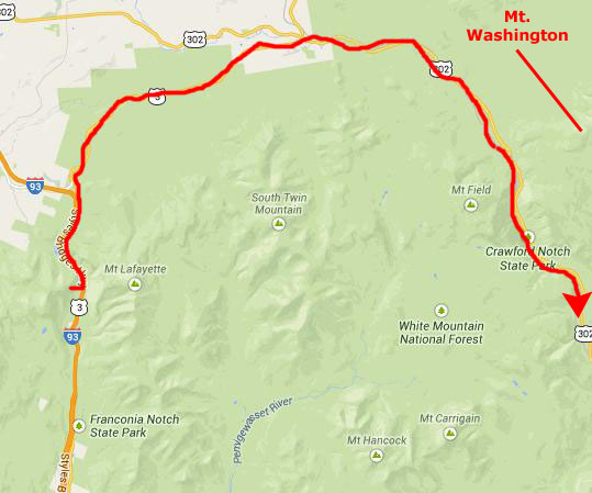
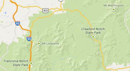
Crawford Notch State Park
|
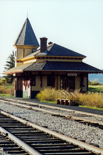
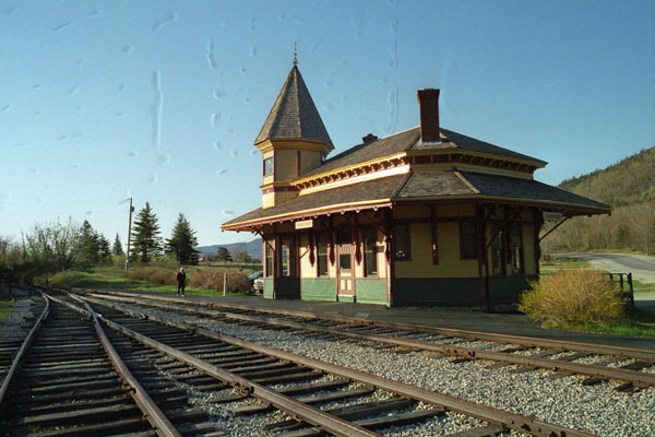
We went on past the entrance to the town of Crawford. We had been seeing signs along this highway for one of New Hampshire's scenic trains- the Crawford Notch Railway. And when we came out into the small valley where the town of Crawford was located, we could plainly see the Crawford Station for this scenic railway.
|
 |
It was getting late, so we thought we'd wend our way back down to the hotel, passing through Crowford Notch State Park as we went.
|
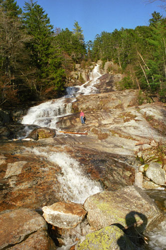
The falls, which are a very short hike east of the highway, are about 200 feet high. As it turned out, the short trail to Arethusa falls also took us along Bemis Brook and past Coliseum Falls. We passed Coliseum Falls about a half mile into the hike, and about three-quarters of a mile after that came to Arethusa falls. These falls are best viewed from below, when you can look up at the long stretch of cascades. We did a fair amount of rock scrambling here in the late afternoon; since the falls were on the west side of a mountain, they were in sunlight until quite late.
Click on the thumbnail images below to see some of the other pictures we took here at Arethusa Falls:
 |
Our light was fading as we left the falls, and so we just drove down through the very scenic state park with the windows down, passing picturesque little towns and hotels and inns until we came back to a highway that would take us back to the interstate. We had dinner when we got back close to the hotel. (Actually, the Red Roof Inn had been full for Saturday night, and so I'd moved us to a Holiday Inn Express right nearby.
Sunday on Mount Washington
|
There is actually an auto road up to the top of Mt. Washington, but it begins on the east slope, and would have been quite a drive for us to get to. And it would not have been nearly so interesting as taking the cog railway that we'd heard so much about. That's why we decided to do it this way.
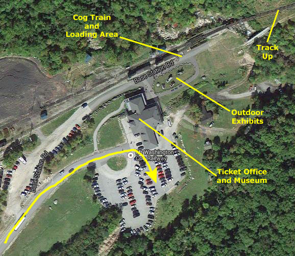
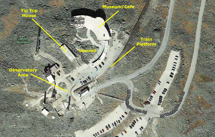
Let's take a look at an aerial view of the area between and including the Marshfield Station (the base station for the cog railway) and the peak of Mt. Washington:
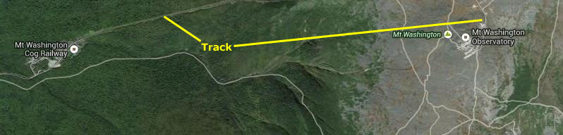 |
The two-mile entrance road from Highway 302 is entering the view from the left, arriving in the parking area for the base station. (We'll look at the base station in more detail in a moment.) You can see the cog railway track leaving and ascending from the base station going northeast out of the view. It is hard to see it as it comes back into view on the peak, as it blends in to the barrenness of the peak (which we will also see in more detail in a little while).
This was our first visit to Mt. Washington, but it wouldn't be our last. About twelve years from now, we'll be taking a trip to New England with some friends we'll make in 2009, and one of the things we will want to show them is Mt. Washington. You may already have viewed that page in this album but if you haven't, you might want to after looking at this one. At that time, I'll have a movie camera with me, and you'll be able to watch some movies of the base station, the cog railway in action, and the things to do at the peak.
|
We spent quite a bit of time here today- staying until mid-afternoon. (We would have stayed later, but Fred had to make a 9PM flight back to Dallas from Boston, which meant we'd have to leave Mt. Washington about 4PM or so.) We took a fair number of pictures, too. First, we'll arrive at Marsfield Station, get our tickets and board the train. Then, we'll take the train ride to the top of the mountain and spend some time there, taking pictures of the expansive views and touring the museum and other facilities. Along about 3:30PM, we'll have to think about leaving and heading back down to Boston.
At Marshfield Station
|
We parked the car went over to the ticket office to buy our railway tickets. (Later, we were to make a mental note that if we ever visited here again, even in mid-summer, we would bring jackets or sweaters with us. It wasn't cool here at the base station, but we were distinctly chilly as we were wandering around on top of the mountain.) We walked around to the northwest side of the station building and went downstairs to the ticket office to buy our tickets for the ride to the top.
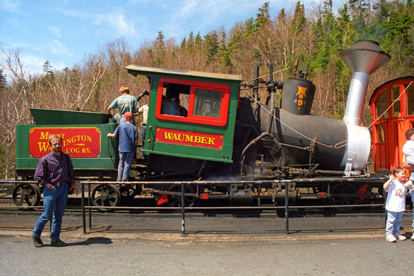
We were able to get tickets on the very next train; today was not a particularly busy one at Mt. Washington. There was a museum inside the station, but we did not take the time to wander through it. We did get some history of the railway from our ticket brochures, though. That history began in 1852 after a hiker, Sylvester Marsh, became lost near the summit of the mountain. Once he'd found his way back down, he decided that there had to be a better way for people to reach the highest mountain peak in the Northeast. Upon his return home, he immediately started working on a plan to build the world's first mountain-climbing cog railway.
Marsh, a native of Campton, New Hampshire, had made his fortune in Chicago's meat-packing industry and was considered by his contemporaries to be a creative and innovative thinker. However, upon first presenting his idea to members of the New Hampshire Legislature, they laughed at him and said that he "might as well build a railway to the Moon." Undaunted, Marsh began the task of building his mountain climbing railway, working with inventors Herrick and Walter Aiken, a father-and-son team from Franklin, New Hampshire. The task was not an easy one, as equipment and materials had to be hauled by oxen for 25 miles to Bretton Woods, and then another six miles through thick forest to the base of Mount Washington. But on July 3, 1869, 'Old Peppersass' became the first cog-driven train to climb 6,288-foot Mount Washington. It was also the first such mountain-climbing cog railway in the world, beating the introduction of Europe's first such railway (at Mt. Rigi in Switzerland) by two years.
|
There are multiple trains in use on the cog railway; I think I saw at least four. About halfway up the mountain, the track splits for a quarter mile or so to allow two trains to pass. This switching system was one of the improvements made to speed up the process of getting folks up and down the mountain. It allowed multiple trains to be used effectively- reducing wait times significantly.
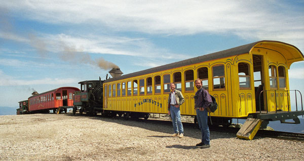
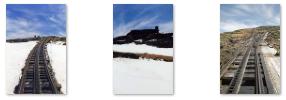
As I said, when we got our tickets, they were for the very next train, which was outside with passengers already bording. Fred took a picture of me and our train. I might mention that after spending a good deal of time on the peak, when we came down, it was on a different train. We went up on train Number 6, but came back down on train Number 9. One thing you can see in both those pictures is that when a train starts out from the station, it is faced immediately with a 40% incline; only a cog train could possibly do that. The maximum grade for regular trains already at full speed is about five percent, and a ten percent highway grade is considered steep. Our trains consisted of basically a single car and an engine, but in the summer months, additional cars are brought out. One engine can push three cars up the mountain.
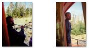
Finally, it was time to board our train. As I am wont to do, I like to sit at the front, but when we boarded, the coach was almost full, and most of the seats at the front were already taken. We got a pair of seats towards the back, but it turned out that this didn't really matter, for when the train started up the mountain, you were allowed to move around, and I could get up to the front and out on the open platform to get good views. Just before we departed, I went to the back of the coach to get a picture of the inside of our car. On our return trip, we were in a different coach with a different group of people, of course, and as it turned out, that coach was almost empty. You can see the inside of our coach coming down here.
Going Up and Down Mt. Washington
From our vantage point at the front of the passenger car, Fred and I had great views of the trip up Mt. Washington. The weather was almost perfect, and we enjoyed the trip immensely.
|
When Fred was out on the front platform, I returned the favor and took a couple of pictures of him, and you can click on the thumbnail images below to see a couple of those pictures:
 |
I liked being up here on the platform; it is always nice, on tramways, railways, subways- almost any kind of conveyance- to be able to see where you are going. At least I think so. Most people, however, seem content to stay in one place and look out side windows, and I will admit that the views out the windows on the trips up and down were good, too. Here is one view out our side windows at the snowy summit of Mt. Washington.
|
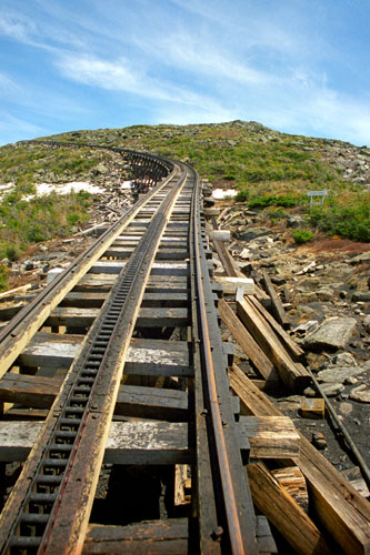
The final portion of the trip up to the top of Mt. Washington took us over a section known as "Jacob's Ladder," perhaps because the grade exceeds 37%- the steepest on this railway and indeed on any cog railway in the country. We had left all the trees behind, and the area we traversed was barren, rocky upland. And, even as late as May, there was still snow on the ground as we approached the peak. Click on the thumbnail images below to see some pictures we took on our way up (or down) Mt. Washington:
|
At one point, we passed a memorial to Lizzie Bourne of Kennebunk Maine, who died here on 14 September 1885. On that day, Lizzie, along with two relatives, tried to climb Mount Washington without a guide. They left the Glen House at the bottom of the mountain at about 2 PM and walked up the then-existing carriage road. They had started out too late, and were still not at the top when night fell. Lizzie was wearing the usual apparel for women of her time, which hindered her movement during a violent gale that came up. Quickly becoming cold and confused, Lizzie died from exposure about 10 PM. When the sun rose, her companions sadly realized they were only a few hundred yards from the summit house. Her family built this monument near the spot where Lizzie perished. And so Lizzie Bourne's spirit continues to survey a view with a circumference of nearly 1,000 miles, including parts of five states and the province of Quebec, although her body is actually buried at Hope Cemetery in Kennebunk, Maine.
As we came around the last part of Jacob's Ladder, we could see the buildings at the top of Mt. Washington off in the distance, and we started getting ready to disembark.
At the Top of Mt. Washington
|
Click on the thumbnails below to see some of the interesting buildings and views here at the top of Mt. Washington:
 |
Now we headed off to see what else we could find up here on the mountaintop.
|
Inside, we wandered through the building for a few minutes. I stopped at the weather station and read about the sixty or so people who have died on Mt. Washington through the years. The museum was on a lower level, with the upper level given over to the cafe and gift shop in a large room with numerous large windows offering views of the panorama outside.
Next, we left the cozy building and headed up onto the observation deck to take in the panorama around us. From the observation deck, and indeed from just about everywhere on the peak, the views were indeed really great. Click on the thumbnail images below to see a few of them:
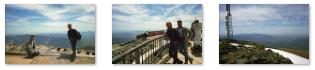 |
We walked around the rest of the area here at the peak and had a look at all the communications and scientific gear scattered about- presumably taking advantage of being at the highest point in this part of New England. Then we walked a bit south to a pile or rocks about fifteen feet high. It was on top of this pile that we found the actual summit of the mountain (see one of the pictures above).
We also stopped at Tip Top House- once a hotel here at the peak. (By the mid-1800s lots of tourists were utilizing the new train service into the White Mountains, and a bridle path was opened to the summit to made it accessible to them. The first hotel, the Summit House, was built in 1852, just feet from the highest crag of Mount Washington. The rugged stone hotel was so successful its first year of operation that a competing hotel, the Tip Top House, was built the following year.) Eventually, it became the offices for a newspaper - Among the Clouds- that was printed on the summit, but when the paper moved to a different building, it fell into disuse and disrepair. The Great Fire of 1908 destroyed the �City Among the Clouds,� sparing only the Tip Top House. The sturdy building was renovated to once again serve as a hotel until a new one was built. Its long history as a hotel ended when it was abandoned in 1968. It is now a State Historic Site and museum.
|
Our trip down was just as enjoyable as the trip up, although because our car was fairly lightly filled, it was easier to move around and get good pictures. By 4PM we were back down at Marshfield Station.
Before we got in the car to head out, Fred noticed some wildflowers some wildflowers growing near the parking area. He went over to photograph them and you can see a couple more pictures here and here.
Fred Leaves for Dallas
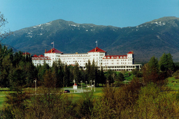
|
His wife, Carolyn Stickney, summered at the hotel for the next decade, adding the Sun Dining Room with guest rooms above, the fourth floor between the towers, and the chapel honoring her late husband. Under its capable first manager, John Anderson, the hotel was a success. But the advent of income tax, Prohibition, and the Great Depression curtailed the hospitality business. In 1936, Mrs. Stickney's nephew, Foster Reynolds, inherited the hotel, which closed in 1942 because of World War II. A Boston syndicate bought the extensive property for about $450,000 In 1944. The Bretton Woods monetary conference took place there that year, establishing the World Bank and the International Monetary Fund. The owners were paid $300,000 for the loss of business and promised a daily room charge of $18 per person for the 19-day conference.
The Mount Washington Hotel and Resort is one of the last surviving grand hotels in the White Mountains, and includes an 18-hole Donald Ross-designed golf course, as well as a 9-hole course on its facilities. It was declared a National Historic Landmark in 1986. The hotel will have its first winter season this very year; up until now it has closed to guests late in the fall and reopened in the spring.
Our drive down to Boston was very pleasant. We stopped twice- once at the Holiday Inn so Fred could collect his stuff, and another time at a diner north of Boston for supper. (I wanted to take Fred to Sol Azteca, the Mexican restaurant I had eaten at so frequently when I worked with Cullinane and IST, but I didn't think there would be time to negotiate downtown Boston. I had Fred at the airport in plenty of time, though, and he was off for Dallas right on schedule.
You can use the links below to continue to another photo album page.
|
May 18, 1999: A Visit With Jack Fontaine in NH |
|
May 8, 1999: Ron and Lowery Leave for Florida |
|
Return to the Index for 1999 |