|
June 30, 2001: Kootenay NP and the Icefields Highway to Jasper |
|
June 28, 2001: Grand Coulee Dam |
|
Return to the Index for Our Canada Trip |
|
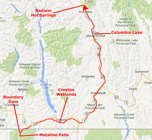
June 29, 2001 The Town of Metaline Falls Boundary Dam Scenic Canada Highway 3 To Radium Hot Springs |
Today, we will aiming to get to a point where we can begin tomorrow by driving through Kootenay National Park in Canada. Our objective is to to stay just outside the south end of this Canadian National Park.
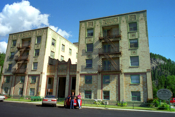
Metaline Falls, Washington
|
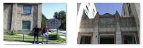
In the morning when we were packed up and ready to go, we took a some additional pictures inside and outside; you can use the clickable thumbnails below to have a look at a couple of inside and a couple of outside pictures:
|
Fred also took an interesting closeup of one of the square medallions that you can see on the building in the picture at left, and you can see that picture here.
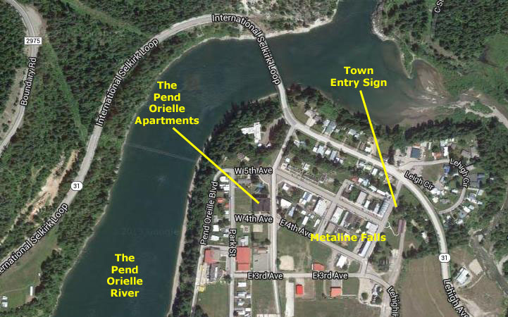
The Pend Oreille Apartments are located just one block from the downtown area of Metaline Falls, WA, which, as we discovered today, is just 12 miles from the Canadian border. Metaline Falls has about 350 residents. The area is very beautiful, surrounded by mountains and lakes and the town is charming. The sister town to Metaline Falls is the town of Metaline located just across the beautiful Pend Oreille River. Metaline has about 250 residents. The area has several restaurants, three bars, grocery store, hardware store, library, mini mart with gas, bakery, post office, and numerous shops and businesses- including this one hotel.
Metaline Falls is the arts center for the area with the famous Cutter Theatre acting as the hub for plays and musicals. Fishing, boating, hunting, hiking, snowmobiling and just about all outdoor activities abound in the Metaline Falls area. Major employers in the area are the Boundry Dam, The Pend Oreille Mine, U.S. Border Patrol and Box Canyon Dam. With not a single traffic light, a pristine environment, the Pend Orielle Apartments hopes to fill up. (However, as of 2014, their web site indicates that they are for sale.)
|
Certainly, this area was quite beautiful, which only became apparent when we got up in the morning and could see it for the first time. Nearby, along the International Selkirk Loop (more in a minute) there are numeroud access points to the Salmo-Priest Wilderness in the Selkirk Mountains and to the Colville National Forest. Here, residents and visitors can find hiking trails traversing the pristine mountain lakes and ancient cedar groves, areas that deliver some of the most striking scenery Washington State has to offer.
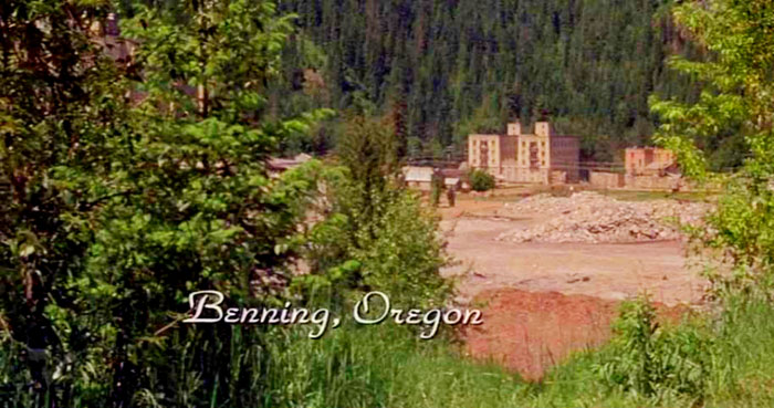
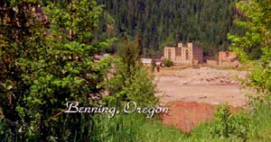
In gathering the information about Metaline Falls for this album (which I did on the Internet in 2014), I discovered a tidbit of pop culture information that I would not have known, and of course didn't know when we were going through the town and the area: the 1997 Kevin Costner film The Postman was filmed in part in the area. This tidbit was intriguing, especially since I have run into the same kind of tidbit at other locations described in this album. So I obtained a copy of the movie and watched most of it on fast forward to see if the scenery looked familiar. If you know the movie, or have a copy of it, you can do the same thing.
|
Does that building look familiar? It should, it's the Pend-Orielle Apartments! From this angle, it's the front of the building. Now, if you look at the aerial view of Metaline Falls above, you'll see that if someone really were southeast of town looking back to the apartment building, the rest of the town would be in the picture. In this view, the town buildings seem to have been airbrushed out or digitally removed. So, I thought, the actual town of Metaline Falls was apparently a filming location.
A little later in the movie, the "bad guy," played by Will Patton, arrives in the same town (whose town signs now, inexplicably, identify it as "Pineview") and as he and his men ride in, they pass a sign that we saw on our way out of town to the east. In reality, it has a circular "seal" that says "Metaline Falls, Washington" around the boundary and "How Can We Help You?" diagonally across the middle. In the movie, the town name was changed to Pineview, Oregon, but otherwise it was the same. The Pend Oreille Apartments (note the pattern of painted bricks on the side of the building) show up a bit later when Patton's men attack the fortified section of the town (you can see a still picture from this attack, and clearly see the rear of the Pend Oreille Apartments building and its distinctive painted brick pattern here), and towards the end of the movie even the Boundary Dam that we visited later in the morning is used as a backdrop (see a still picture from this section here).
|
So, our visit to the small town of Metaline Falls turned out to be more interesting than I might have thought, even though we didn't know it at the time.
You can return to today's index
or continue with the next section below.
Boundary Dam
|
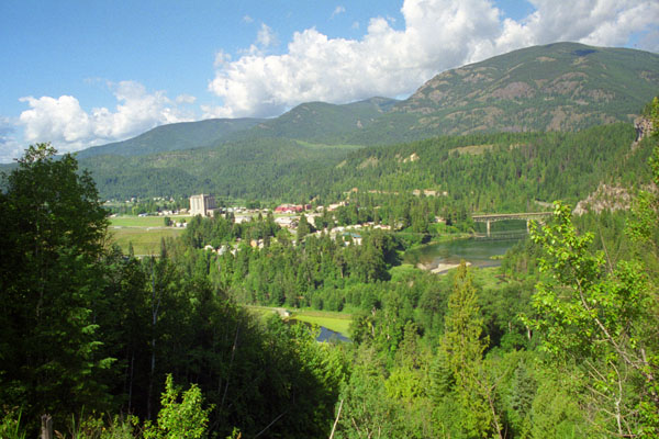
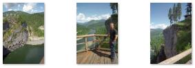
A few miles north of Metaline Falls, the road climbed a bit to a little park or overlook where we stopped. There were good views of the town (including the grain silos that appeared in the movie clips) and some nice views of the Pend Oreille River. Use the clickable thumbnails below to see a couple of more views from the overlook:
 |
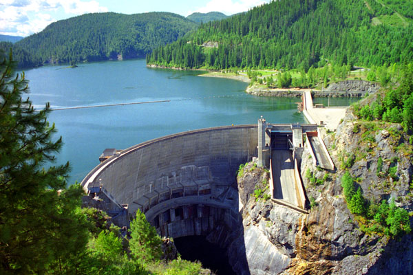
For the next few miles the ride up Highway 31 was really pretty. It was cool and the weather was quite nice. About five miles up the road, we began to see signs for the border crossing, and one for a side road to Boundary Dam, so we thought we'd stop and take a look. We took the marked turnoff to Boundary Dam, which was about a mile west of the highway, and we arrived at a small parking area with a walk down to an overlook that afforeded excellent views both upriver at the dam (south) and downriver.
|
As I mentioned above, a portion of the Kevin Costner film "The Postman" was filmed on the front of the dam, and for a period of time in 1997, the dam's face had a facade of a town (Bridge City in the film). If you use the clickable thumbnails below to see some other views from the overlook, you'll be able to match up the view to the north that you see just before Costner's cable slide ride begins (and yes, that was Tom Petty playing the mayor of Bridge City):
 |
We left the dam a half hour later and got back on the Selkirk International Loop heading north towards Candada.
You can return to today's index
or continue with the next section below.
The Scenic Drive Along Canada Highway 3
|
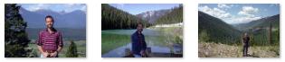
Our route took us through the small town of Salmo, before proceeding northeast towards the southern end of Kootenay Lake. There, we crossed a very pretty river coming out of that lake.
The drive along Canada Highway 3 from Salmo to Creston was quite amazing- beautiful snow-capped mountains, broad green valleys, lakes and streams- and even some local wildlife. We were stopping continually to admire the views, visit a lake or see a stream. (Note: We didn't have digital cameras yet, but I can definitely say that if we had, I would have many, many more pictures of this incredibly scenic area to show you, but film being what it was and costing what it did, we were much more sparing.) Use the clickable thumbnails below to see some of the scenery along Canada Highway 3:
 |
Eventually, we came over the crest of the mountains and we could see Creston ahead of us, down a long slope into a broad valley.
|
The Creston Valley Wildlife Management Area is a Canadian river delta wetland on the floodplain of the Kootenay River at the south end of Kootenay Lake. Predominantly marshland, it was classified as a wetland of international importance on February 21, 1994, and is also a globally significant Important Bird Area. According to its website, it is one of the "few significant agricultural areas of the province", and is in the Montane Cordillera. It stretches north along Kootenay Lake for approximately 15 miles and south to the United States border.
Covering about 50 square miles of provincial Crown land, it is a naturalist's paradise; it is both the only breeding site of the Forster's Tern, the only site in the province with Leopard frogs in the province and one of the few Canadian habitats for the Coeur D'Alene Salamander. Creston Valley provides staging and nesting areas for migratory birds on the Pacific Flyway. The wetland also contains the 10-square-mile Duck Lake and 17 marshes. The Purcell Mountains are to the east, and the Selkirk Mountains, through which we had just come, to the west.
To the east are the Purcell Mountains and to the west the Selkirk Mountains.
The wetland is managed by the Creston Valley Wildlife Management Area to prevent invasive species from establishing themselves in the wetland, particularly targeting cattails or reed canary grass. This is done by periodically drawing down the water level of the marshes. Areas that get completely choked with vegetation are intentionally drained and dried and then plowed up to get rid of the seed bank that develops over time. This also ensures broad biodiversity by preventing one plant species from dominating the region.
From the wetland, we passed through the town of Creston and continued eastward.
You can return to today's index
or continue with the next section below.
The Drive from Creston to Radium Hot Springs
|
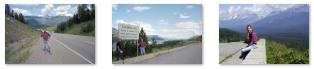
Use the clickable thumbnails below to have a look at three examples of this amazing scenery:
 |
Fed by several small streams, Columbia Lake is the primary lake at the headwaters of the Columbia River. We passed through the village of Canal Flats, located at the south end of the lake, and continued on beside the lake for a ways. The lake is unusual in that it has an average temperature during this part of the year of 65°, making it the largest warm (everything is relative) water lake in the East Kootenay. It has a typical depth of 15 feet with excellent water clarity as it enjoys a much smaller volume of boat traffic than its northern neighbour, Windermere Lake.
The Kootenay River, a major tributary of the Columbia, passes within a few thousand feet of the south end of the lake, somtimes actually overflowing into the lake. There used to be a canal connecting the two, but it was only used three times.
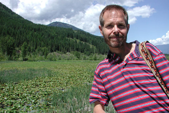
At Radium Hot Springs, there is a highway that leads up the mountainside and into Kootenay National Park. It was late in the afternoon by the time we got here, so knowing that we were losing our light we decided to stay at the Best Western in Radium Hot Springs. But there was still some light, so we drove up to the west entrance to the park, it would be best to do it this afternoon, for tomorrow this face of the mountains would be in shadow until almost eleven. I'm glad we did, for the west entrance was quite pretty, with the curved road and the litle stream that was coming out of the park into a little waterfall right beside it. We drove through the park entrance and to the point where the park highway goes through Sinclair Canyon and into the park. We actually continued on into the park a ways, just to see what it was like, and we discovered that the same stream that came out through the crevice paralleled the highway heading north. We stopped and Fred took a picture of me beside the little stream.
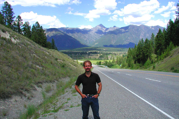
Returning out the park entrance, we stopped on the west side of the entrance where I got a picture of Fred at the western overlook. As you can see, taking pictures into the setting sun can be difficult. We went back to the Best Western to check in and have dinner at a little local place in town.
You can return to today's index
or use the links below to continue to another photo album page.
|
June 30, 2001: Kootenay NP and the Icefields Highway to Jasper |
|
June 28, 2001: Grand Coulee Dam |
|
Return to the Index for Our Canada Trip |