|
July 1, 2001: Jasper National Park and Yolo National Park |
|
June 29, 2001: The Trip to Radium Hot Springs |
|
Return to the Index for Our Canada Trip |
|
June 30, 2001 Kootenay National Park Banff National Park The Icefields Parkway Postscript
|
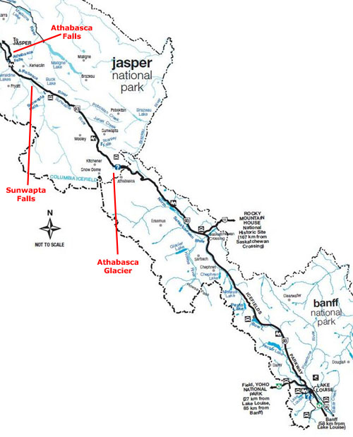
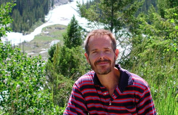
Today, our objective will be the town of Jasper, at the northern end of what is known as the Icefields Highway. Between Radium Hot Springs and that destination, we will drive through Kootenay National Park, a part of Banff National Park and along the Icefields Highway. We have planned to stop at a number of water features, some geothermal features and at least one glacier.
Driving Through Kootenay National Park
|
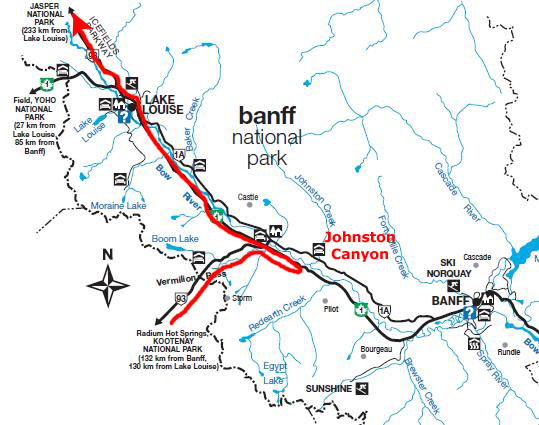
I have marked some of the stops we made on the diagram, including Olive Lake, Numa Falls, the Paint Pots, Marble Canyon and, of course, the Continental Divide itself.
I'm also going to subdivide this section along the lines of those places we stopped.
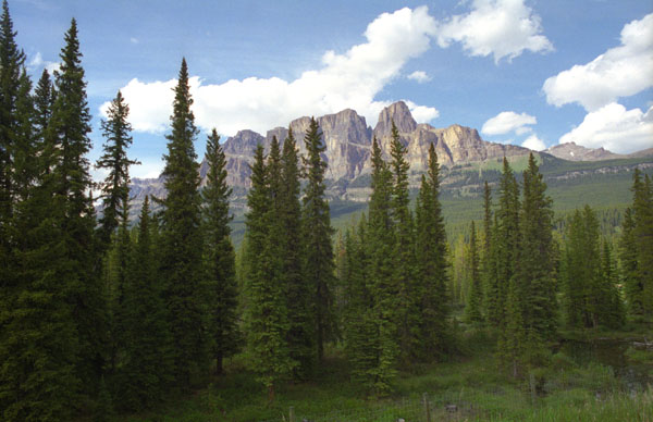
Kootenay National Park is located in southeastern British Columbia, and covers 543 sq. mi. of the Canadian Rockies; it forms part of a World Heritage Site. During our drive, we were pretty constantly ascending; the park ranges in elevation from 3,012 ft. at Sinclair Canyon to 11,234 ft. at Deltaform Mountain. Kootenay is one of the four contiguous mountain parks in the Canadian Rockies; the other three being Banff National Park directly to the east, Yoho National Park directly to the north, and Jasper National Park (to the north of Yolo and Banff).
Kootenay and the other three parks see most of their tourism in the summer, of course, since winter travel conditions are usually arduous. The park takes its name from the Kootenay River, one of the two major rivers which flow through the park; The Vermillion River is the other. Both eventually empty into the Columbia. The park highway follows the path of both rivers through the park.
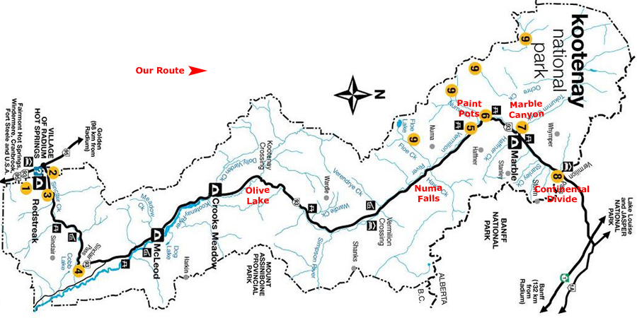
Olive Lake
|
 |
Olive Lake is not far from Radium Hot Springs, and is one of Kootenay National Park's main attractions. It is a small, clear green, spring-fed lake with a wheelchair accessible boardwalk trail featuring interpretive panels around it. It is a day use area for picnicking, wildlife viewing and bird watching. We took the half-mile boardwalk path leading to two viewing platforms overlooking Olive Lake. The picture at left was taken at one of them.
We got back on the highway to continue on northward, and very, very quickly the scenery became not just pretty or beautiful, but truly spectacular.
|
Use the clickable thumbnails below to see some of the amazing scenery we saw as we drove north through Kootenay:
 |
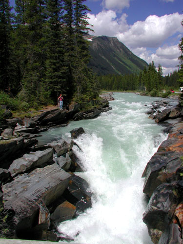
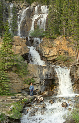
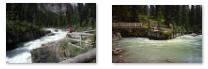
We were about halfway along the highway when we got to the next place we wanted to see- Numa Falls.
Numa Falls
|
 Returning from Numa Falls |
From the falls, we could see pretty far back up into the mountains; even at a fairly low level, there were still remnants of the winter snows.
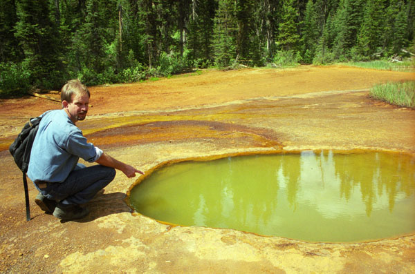
The Paint Pots
|
Within the Cambrian rocks surrounding the area there is a high amount of iron, magnesium, lead and zinc elements, and these elements have found their way into the pools, giving them their variety of colors. As the spring outlets of the paint pots flow into the Vermillion River, much of the mineral composition is deposited into the River (most of the lead, three-quarters of the magnesium and zinc and a little less than half of the iron).
With the fast rushing water of the river and the mixing of the acid water with limestone, much of the acidic water is diluted and reduces any pollution (studies show that limestone and oxygen help retain normal surface water pH levels as the iron, magnesium, zinc and lead are predominantly removed).
When we got to the pools, we found ourselves not only standing beside a Yellowstone-like geothermal feature, (although because the water is actually cold, I don't know that "geothermal" is the right term), but standing in a clearing dominated by Numa Peak.
The Paint Pots have a history of stories told and untold from travelers long ago. The landscape among this trail is one that is truly unique and adds to the profound diversity of Kootenay's National Park's scenery. The interpretative trail took us through a history of time with remnants of the earth's natural, iron rich ochres and left over equipment that once were important to both the First Nations and the Europeans respectively.
|
The landscape surrounding the Paint Pots is uniquely created as well. The iron ore accumulates around the edge of these 3 pools thereby increasing their height. As a nearby stream flows into 2 of the larger pools, a greenish color is created. As these mineral pools bubble up, the iron ore stains the earth around the pools an orange-red color. The material itself can look and feel like clay and can be found in a variety of colors from red to orange to yellow; red ochre because of hematite mineral or be yellow ochre because of limonite mineral.
Marble Canyon
|
You can use the clickable thumbnails below to see some views of Marble Canyon from the interpretive trail:
|
We were almost through Kootenay National Park, now, and were expecting to come to the boundary between it and Banff National Park quite soon. Before we came to that boundary, though, we did arrive at the northern entry area for the park.
|
Then we headed up the road to the Continental Divide.
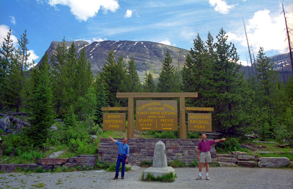
The Continental Divide
|
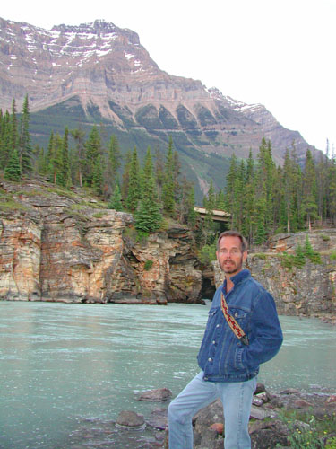
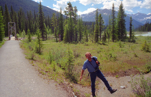
The summit of Vermilion Pass is a three-fer; we are at three different boundaries simultaneously. Of course we are at the boundary of the Pacific and Atlantic watersheds, and as I mentioned also the provincial border, but we are also at the boundary between Kootenay and Banff National Parks (as the sign we are standing in front of indicates). In case you can't read it, the elevation on the sign is 5382 feet above sea level, so we are almost exactly a mile high here.
So now we'll leave Kootenay National Park and enter Banff National Park.
You can return to today's index
or continue with the next section below.
In Banff National Park
|
We'll only be making one planned stop here in Banff National Park- at Johnston Canyon. We'll be making other stops along the Icefields Parkway, but we'll deal with those in the next section.
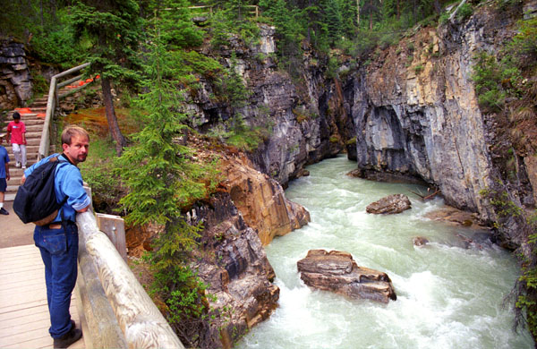
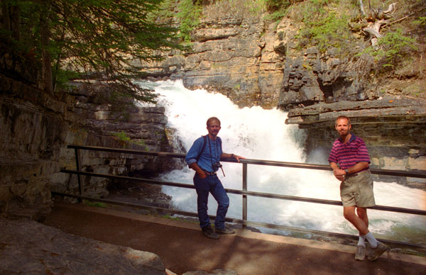
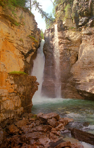
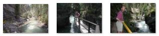
Johnston Canyon
|
From the parking area, we headed up into the canyon on a system of walkways hanging off of the cliff faces, bridges that spanned the creek, and dirt paths where there was enough room for them. There were numerous overlooks and views- all of them backed up by the roar of the creek flowing through the narrow canyon. It had gotten warm this afternoon, and for this hike I changed into shorts.
Use the clickable thumbnails below for some views of the canyon along our walk:
 |
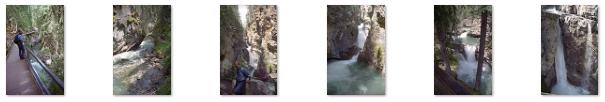
While the first part of the trail consisted of a constructed walkway with safety rails and bridges, the last part of the trail was natural and more rugged.
|
Johnston Creek empties into the Bow River, south of Castle Mountain, between Banff and Lake Louise, at an elevation of about 4,700 feet.
This canyon has been formed by erosion over thousands of years. The creek has cut through the limestone rock to form sheer canyon walls, as well as waterfalls, tunnels, and pools. Ice climbing is a popular activity on the frozen waterfalls in winter. We thought that the canyon was pretty amazing, not just for the natural beauty but for the fact that Parks Canada had created such an interesting trail that gives people the opportunity to enjoy that beauty.
We took lots of pictures on the way in and out, and you can use the clickable thumbnails below to have a look at some of them:
 |
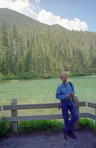
Coming out of the canyon, we got back on the Trans-Canada Highway heading north towards Lake Louise and beyond that, the beginning of the Icefields Parkway. We took some random pictures as we went along, and we stopped at a few overlooks and viewpoints. Two of the best of the pictures we took are below:
 |
 |
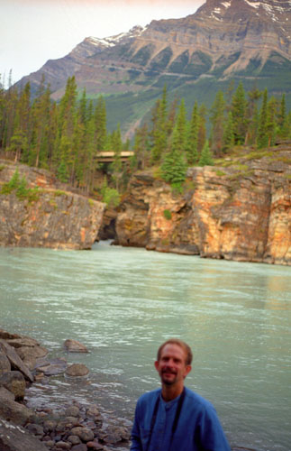
The left-hand picture was taken at one overlook and you can see some late melting snow in the background; the other was taken just south of Lake Louise. Some of the other pictures we took included some local wildlife, and you can see a couple of those here and here. As we got onto the Icefields Parkway, it was clouding up, making this picture of Fred and the Bow River a bit dark.
You can return to today's index or continue with the next section below.
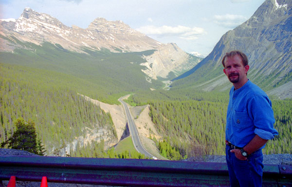
On the Icefields Parkway
The parkway is busy in July and August with up to 100,000 vehicles a month. The parkway is mainly two lanes with occasional passing lanes. It minimizes grades and hairpin turns but travellers must look out for wildlife, and vehicles stopped on the shoulder. Snow can be expected at any time of year and extreme weather is common in winter. A Canadian national parks permit is required to travel on the Icefields Parkway; stations near Lake Louise and Jasper enforce the law (we bought ours just north of Lake Louise). Commercial trucks are prohibited. The speed limit is 90 km/h (55 mph) although the limit is reduced at Saskatchewan River Crossing and the Columbia Icefield area. In winter, road closures are not uncommon. |
The 140-mile Icefields Parkway, completed in 1940, parallels the Continental Divide, traversing the rugged landscape of the Canadian Rockies, travelling through Banff National Park and Jasper National Park. It links Lake Louise with Jasper to the north. It is named for features such as the Columbia Icefield, visible from the parkway. The scenery along the parkway is nothing short of spectacular.
|
When we passed through Lake Louise, there was a kind of entrance station for the parkway, which was really just a building off to the side of the roadway. Unobtrusive signs told of the permit requirement, so we bought our $5CN permit there. Then we began the drive north to Jasper. Driving straight through, the trip is less than three hours, but we would stop numerous times to take in the scenery, the glaciers and the waterfalls. I've marked our major stops on the park diagram above.
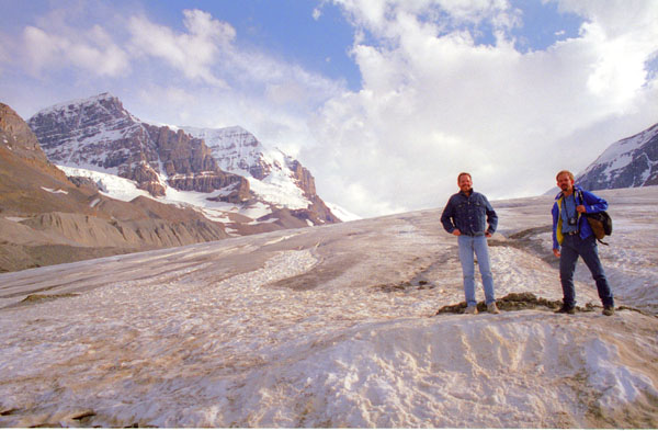
The Athabasca Glacier
|
Use the clickable thumbnails below to see some of the pictures we took on the glacier:
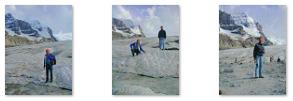 |
The glacier is approximately 3.7 mi long, covers an area of 2.3 sq mi, and is measured to be between 300 and 1000 feet thick.
This particular glacier (as is true with many around the world) is retreating. Currently, it is receding at an average rate of 8 feet per year, and has receded about a mile in the past 125 years (reliable measurements are only that old). It has also lost half its volume in that same period.
|
We took a picture of the glacier from the highway and had to visualize what it might have looked like where its forward edge literally at our feet; it would have been an amazing sight.
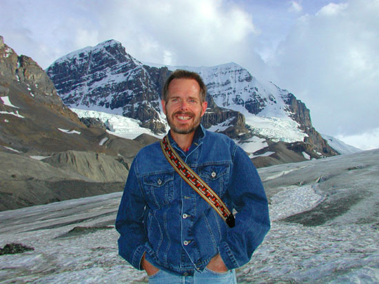
I happened to get one other picture I want to include here. I was taking a picture of Fred at the glacier's edge when the sun happened to go behind a thicker cloud, so the picture darkened and the sun appeared gauzy, making everything look colder. You can see that picture here.
The Icefield Interpretive Center, was across the highway from the glacier. We would have stopped in, but we had other stops to make this afternoon, and didn't want to lose our light prematurely. We presumed that tickets could be purchased their for guided tours; we saw groups riding buses to the glacier edge, where they transferred to odd-looking vehicles that took them further up the glacier than we walked.
Walking up on the glacier was a really neat experience, one that I not had before (or since, as it turns out). Looking just at your feet or a short distance around yourself it is easy to imagine yourself on a snow-covered lawn, but when you look up and across this river of ice it is an entirely different experience.
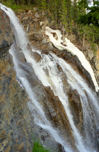
Sunwapta Falls
|
The Sunwapta Falls weren't far away, though, and another fifteen minutes brought us to them and to the Sunwapta River. What we found when we arrived was two sets of falls coming out of a lake-like area of the river. "Sunwapta" is an Assiniboine word that means "turbulent water". It is most spectacular in the late spring when the spring melt is at its peak.
|
The water originates from the Athabasca Glacier, and volumes are higher in early summer, caused by glacial melting. Those upper falls have a 60-foot drop, and are about 30 feet wide.
Below the upper falls there is a wide space in the river where we stopped to take pictures of each other. The lower falls were not nearly so spectacular.
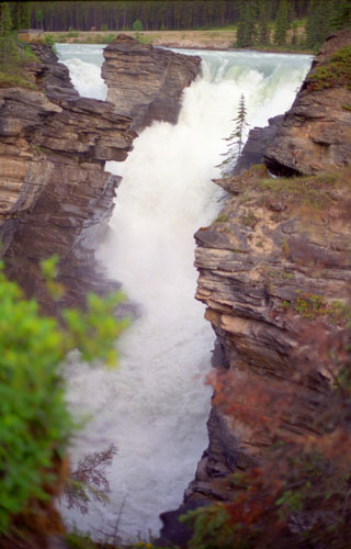
Athabasca Falls
|
The river 'falls' over a layer of hard quartzite and through the softer limestone below carving the short gorge and a number of potholes. The falls can be safely viewed and photographed from various viewing platforms (you can see Fred standing on one of these platforms with the falls in the background here) and walking trails around the falls. Our parking area was just off the highway. White water rafting often starts below the falls to travel downstream on the Athabasca River to Jasper.
From Athabasca Falls, we continued the last fifteen miles up the Parkway to Jasper, which we reached in the early evening. There, we just looked around for a hospitable place to stay, and chose a Best Western near the center of town, adjacent to a park. I found the hotel a bit odd, with a first floor partially sunken into the ground. Fred, who has done a lot of skiing, told me that this is quite common in very cold climates to take maximum advantage of the insulation that the earth provides. He also pointed out the roofs that sloped way out over the windows, helping to ensure that they not be totally obscured by snowdrifts.
You can return to today's index or continue with the next section below.
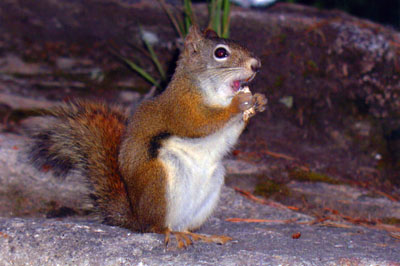
Postscript
|
|
The Brandts submitted the photo to the National Geographic weekly "Your Shot" contest in a bid to have the image included in an upcoming issue. As a result of the picture's being printed, it "went viral" in other publications and on the Internet. (The appeal of the picture is related to both the fact that the squirrel is perfectly in focus, and that its pose is reminiscent of the gopher from Caddyshack.
The photo of the squirrel has since been used by the Banff tourism board to attract visitors to the area, and indeed the park saw a brief surge in visitors shortly following the viral spread of the image. The "Crasher Squirrel" currently has a Facebook page and a Twitter account. The Banff Tourism Board has reported that by late summer, over 82 million "click-throughs" were generated by these and other social media sites, as well as sites of involved publications. The squirrel was made an honorary citizen of Banff in October 2009.
The insertion of squirrel images in other photos has furthered the meme, and has been used for photographs of official diplomatic gatherings, family portraits, and famous works of art so that the squirrel appears to be crashing these gatherings. A website, "The Squirrelizer", was created by a Scottish web developer to allow anyone to add the image of the squirrel to a photo; the site saw more than 130,000 hits within a week of its creation. That site is now down, but now "there's an app for that."
We feel honored to have met the Crasher Squirrel when he was just another fluffy-tailed rodent.
You can return to today's index
or use the links below to continue to another photo album page.
|
July 1, 2001: Jasper National Park and Yolo National Park |
|
June 29, 2001: The Trip to Radium Hot Springs |
|
Return to the Index for Our Canada Trip |