|
July 12, 2002: Colorado Trip Day 7 |
|
July 10, 2002: Colorado Trip Day 5 |
|
Return to the Index for Our Colorado Trip |
|
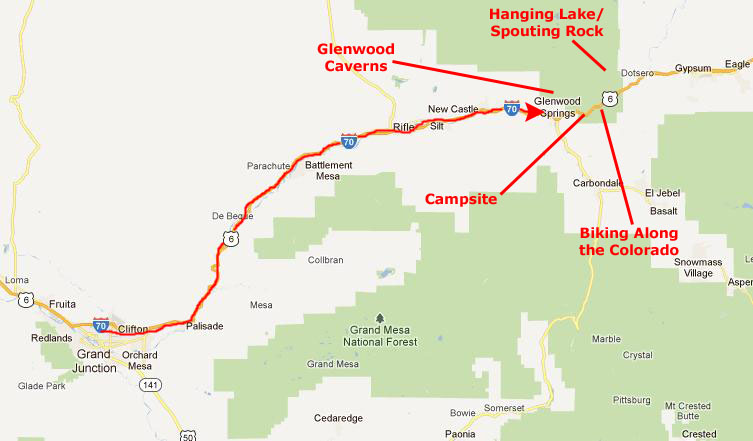
Hiking to Hanging Lake Spouting Rock Visiting Glenwood Caverns Biking Along the Colorado River Camping on the Colorado River |
Today we'll be doing stuff in and around Glenwood Springs, which will be our camping destination this evening. East of Glenwood Springs we'll hike to Hanging Lake and Spouting Rock. Then we'll return to Glenwood Springs to visit the Glenwood Caverns. Finally, after we get our campsite set up, we'll rent some bicycles and utilize the beautiful bike paths that parallel both I-70 and the Colorado River.
|
We planned to overshoot Glenwood Springs first and do the Hanging Lake hike, since we were coming from the west and there would be a convenient exit for it. We'd also planned to take the extra time to go to Spouting Rock, which is actually just above the lake.
Then we'll come back to Glenwood Springs to tour the Glenwood Caverns. After that, we'll check in at our campground (we'd already made a reservation there) and then see if we can rent some bikes so we can take advantage of the beautiful bike paths that have been built along I-70. The path is one of the longest single bike paths in the country, and the scenery should be spectacular.
Hiking to Hanging Lake
|
In the years following the area served as a homestead, and a private family retreat until it was purchased by the town of Glenwood Springs in 1910. It then began a long history as a public tourist stop, and later during the 1940s hosted a resort and cafe. When the construction of Interstate70 began in 1968, it became apparent that travelers were going to be more likely to get to Glenwood Springs in a single drive from Denver, and the resort and cafe closed. In 1972 the area was returned to the protection of the Forest Service as part of the White River National Forest, and the lake and trail have become increasingly popular since.
In 2011 the lake was named a National Natural Landmark, although that event was a good ways into the future when we visited.
|
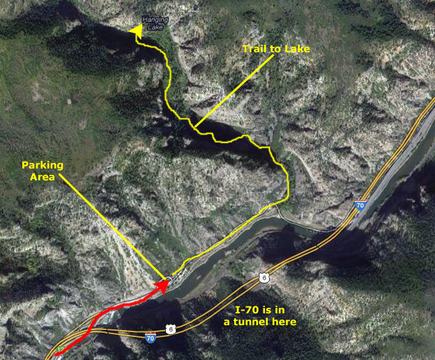
The parking area is well taken care of as it serves a dual purpose of rest area and trailhead, and it sits in the bottom of the canyon along the banks of the Colorado River several hundred feet upstream from the Shoshone Dam. This dam diverts a portion of the Colorado River through a tunnel in the mountain to the Shoshone Power Plant several miles downstream. Several months of the year (winter) just below the dam, one could cross the Colorado River literally by stepping and jumping from rock to rock however during the spring runoff river roars through the channel creating water that is unnavigable by any sort of white water craft; at least two people have died trying.
The Amphitheater with I-70 in the distance. From the parking area the first quarter mile or so of the hike is really just a walk along the bike path that runs the length of Glenwood Canyon. Just before we turned onto the trail itself, we passed a rock with a number of large and small anchors in it. Logically called "Anchor Rock," it is used by the rock-climbers who traverse the cliffs above us near the highway. From the actual beginning of the trail we could look upriver to see the massive amphitheatre that has been carved by the river over tens of thousands of years. We then turned north and headed up the trail.
|
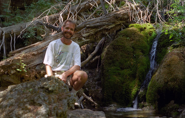
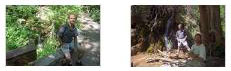
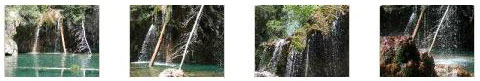
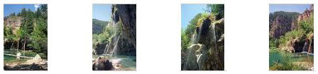
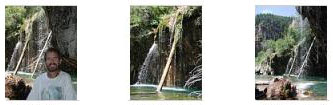
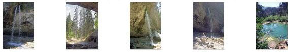
It was really neat, passing one small waterfall after another, and we took quite a few pictures. Click on the thumbnails below to see a couple of pictures of Fred along the creek and at the waterfalls:
|
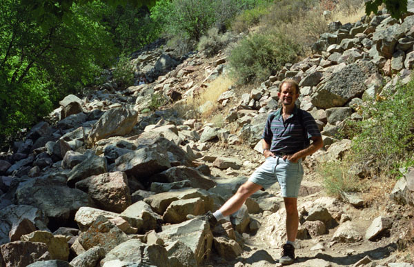
We could definitely feel the cooling effect from the shade at this time of year, and it was very welcome. Hiking a bit further, we passed a sign to Deadhorse Trail on our right. That trail doesn't go to Hanging Lake, but instead takes a steep climb towards the top of the canyon and the meadows above. We stayed on the main trail and crossed that little creek five or six times. We didn't have a problem with the hike, but we did notice that there were benches and even a little shelter for hikers that might be a bit winded.
|
We knew from our trail guide that to get to Spouting Rock we'd return to this fork and take the other trail. But for now, we made a sharp right turn and began to follow the canyon wall (now on our left). As we begin to climb, we found hand rails we could use for stability. After about a hundred feet we were no longer on a trail per se but climbing steps (as high as a foot and a half) carved into the rock with the railing still available for assistance. This was the steepest part of the entire hike, but it was only up 45 feet vertically and practically a stairway.
After the short climb, we got to the top of the stairs and our destination was near.
|
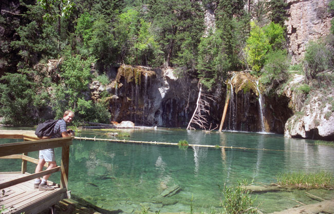
The boardwalk follows the south side of the lake just above a marshy outlet. Along the boardwalk there are two boardwalk overlooks where you can stand and look across the lake at the waterfall which is the source of this beauty. It wasn't only the lake that was beautiful, though, there was quite a view to the south down the canyon and back the way we'd come.
The fragile shoreline of Hanging Lake is composed of travertine, created when dissolved limestone from the Mississippian-aged Leadville Formation (through which the Dead Horse Creek flows) was deposited on rocks and logs, creating travertine layers. Our trail guide indicated that the oils from human skin speed along the erosion of the travertine, and so hikers shouldn't wade in the water, but we did see a couple of folks stick their feet in nevertheless.
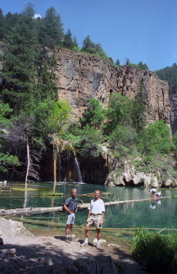
I know that many of the pictures we took here at Hanging Lake are somewhat repetitive, but the lake was so beautiful that it was hard to resist snapping away. For Fred, with his digital camera, pictures cost nothing (aside from the cost of the camera). But I was still using film (I will have to remedy that soon), and so I was a bit more judicious in my picture-taking, since film and developing cost a certain amount per picture.
|
|
|
|
We spent a fair amount of time wandering around Hanging Lake and enjoying its beauty.
|
|
Watch Fred's short film with the player at right.
NOTE:
As you may be aware, I began creating this online photo album in 2005, when I had the tools and the time to do so. Now that I am working on years prior to that, some of my narrative (and some of the information I obtain from the Internet to include in the album) reflects the experiences of the present day. For example, I said earlier on this page that in 2011, Hanging Lake became a National Natural Landmark. Obviously, I could not have known that in 2002 when we did this hike. That's an example of the kind of thing I'm talking about. It is tough to construct the web pages with the tools and information available at the time; there is no way to look at the Internet as it existed in 2002. But this gives me the opportunity to add a "looking back on it" perspective, and I think that as I work backward, more and more of this will creep in. (The very fact that I am working backward in the album from the present creates its own set of inconsistencies; this comment should appear on the pages for 1968.) In any event, my comment above about silent films, while I might logically have made it had I written this narrative in 2002, was inserted as a bit of humor: just a couple of weeks ago, a silent film ("The Artist") won the Oscar for Best Picture at the 2012 Academy Awards.
|
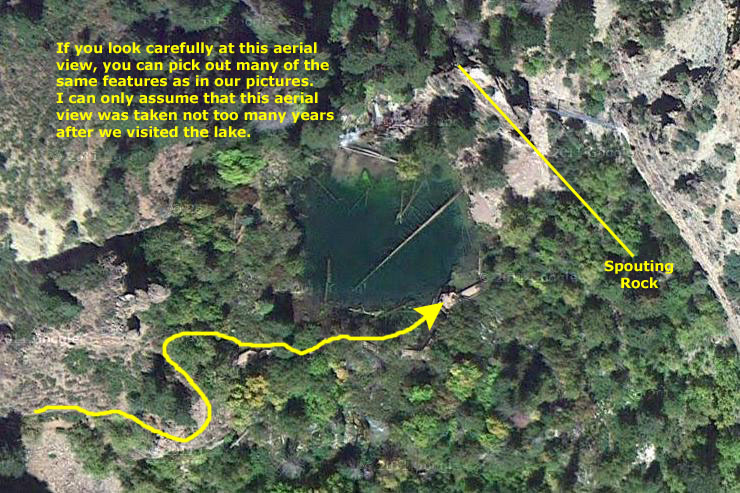
I was pleasantly surprised to find that the aerial resolution was actually very, very good- on par with, say, downtown Chicago. Perhaps it is because of the popularity of the hike, but more likely it is due to the lake's proximity to I-70; I find that, like cell service, the major interstate highways tend to have good resolution, at least for a distance on either side. I am happy to be able to include these aerial views; back in the 1990s, no one contemplated that this kind of material would be available to the public.
I was also amazed at how little the lake seems to have changed since our visit- right down to the logs laying in the lake. But then I have no idea when the aerial view was taken; it may just have been a couple of seasons later, and that would not be enough time for the trees and stuff we saw in the lake to have decayed out of existence.
Well, now it's time to head off to have a look at Spouting Rock.
You can return to today's index
or continue with the next section below.
Hiking to Spouting Rock
|
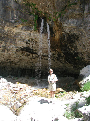
We took lots of pictures at this amazingly beautiful place, and if you will click on the thumbnail images below, you can see some of them:
|
Spouting Rock was certainly an unusual formation, and we wandered around for a good while taking pictures and movies. Again, Fred used his digital camera to take a couple of movies of Spouting Rock, and you can watch them with the players below. Still no narration, though.
|
|
You can return to today's index
or continue with the next section below.
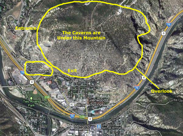
Visiting Glenwood Caverns
|
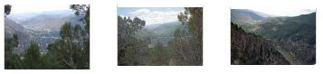
Anyway, we waited for the next shuttle and it took us up to the entrance to the caverns. Just before we headed on into the caverns, we took some picture of the town of Glenwood Springs spread out below us. You can have a look at these pictures by clicking on the thumbnails below:
|
Then, after we got a short talk outside covering the history of the caverns, our group followed our tour guide into the caverns.
|
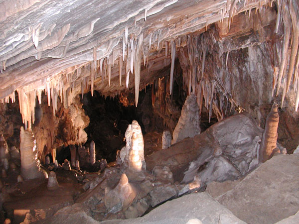
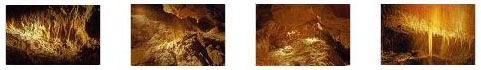
On our walking tour of the caverns and fairy caves, we journied down into the mountain, and the entire experience was very enjoyable. Some caves have spots that are a tight squeeze, but not here. Mostly we explored huge wide-open underground rooms. This was both good and bad. It was good in that the rooms were pretty spectacular, but it was bad in that most of them were so large that casual flash photography didn't illuminate them enough. So we had to content ourselves with pictures of some of the formations and stuff close up.
The Walking Cave Tour lasted a little over an hour, and we saw quite a bit. At one point, our guide pointed out a small passageway that she said led to another series of rooms that hadn't been fully explored. There were perhaps fewer stalagtites and stalagmites than we have seen in other caves, but there was an interesting set of two almost‑identical side‑by‑side stlagtites; I don't recall seeing anything quite like them before. The passageways were well-maintained and the caverns nicely lit- which was good because there were, occasionally, stairs to climb or descend.
We did take some good pictures here in the caverns; Fred was just getting used to his digital camera and so many of his digital shots didn't turn out well. But all in all, we ended up with a nice selection. Click on the thumbnail images below to see the pictures we took in the caverns:
|
|
There was one feature of Glenwood Caverns that I have never experienced before, and it has to do with the fact that the caverns, while they are below ground level (of course) are not below the level of Glenwood Springs or the Colorado River. In fact, most of our walking was done at an absolute level a few hundred feet above Glenwood Springs. This led to the unique feature- about midway through our tour, our guide led us through a metal door and down a stone hallway. We could see daylight at the far end, and when we came out, we were on Exclamation Point, which is actually a cliffside balcony with panoramic views of Glenwood Canyon and the Colorado River. All the other caverns we've been are under the prevailing ground level for the area; this was the first one we'd toured that was basically inside a mountain, high up.
The other interesting thing was that the tour led us generally south, so that when it ended, and we emerged from the caverns, we took an elevator down which put us back within walking distance of where we'd parked the car when we bought our tickets. Kind of like being routed through the gift shop at the end of a theme-park ride.
It was getting on to late afternoon, so we thought we'd go ahead and check in at the campground and get things set up.
You can return to today's index
or continue with the next section below.
Biking Along the Colorado River
|
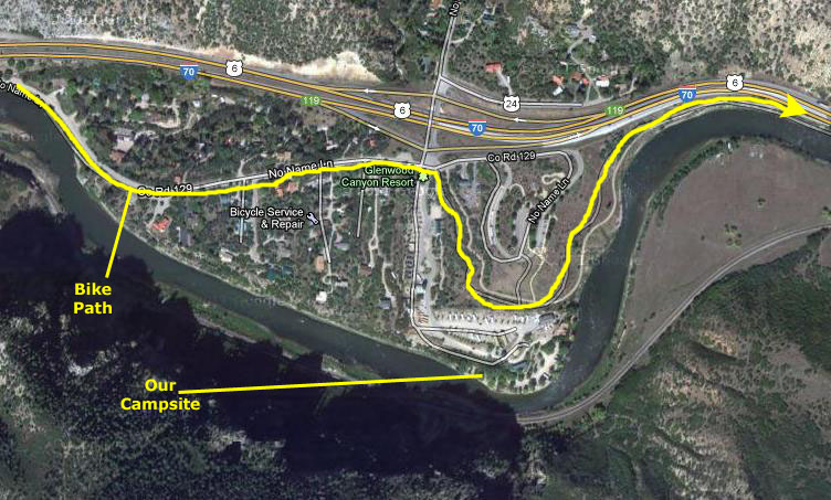
It is hard to describe the bike path, and the aerial views don't do it justice. It is entirely separate from the highway, sometimes paralleling it on the same level but more often down below or underneath it. Where there are exits, the path might cross the exit road or it might detour south to the river to bypass whatever services or residential areas might be at that exit. Every effort seemed to have been made to ensure that bikers rarely had to get close to traffic.
Only a short while after we left the campground area behind, we were the only two people around. The path was almost deserted; I think we passed only one or two other bikers. It was a weekday and late in the day and those two factors must have accounted for the dearth of bicyclists. I can only imagine what it is like on weekends, though. It was a very, very enjoyable ride, and if you will click on the thumbnail images below, you can see some of the pictures we took with Fred's digital camera while we were riding along:
|
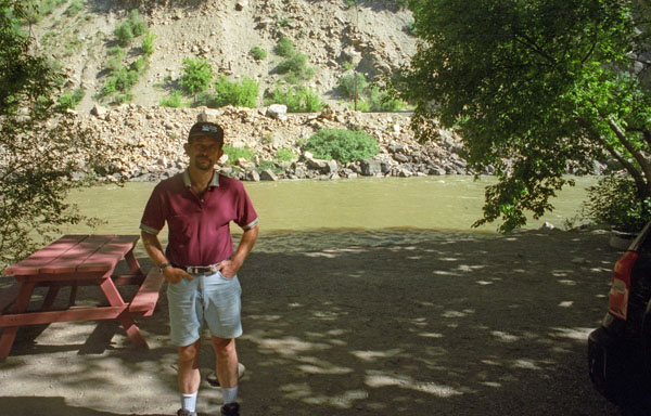
As I have said before, creating this photo album with the resources now available on the Internet is a lot of fun, especially when I can match a picture to an aerial view. Here is an example of what I mean. Below, left, you can see one of the pictures that Fred took of me. In the background, you can see I-70 going into one of the three tunnels that we passed on our ride. Because it is late in the day and the sun is already lower than the mountains, there's no obvious way to tell whether the shot faces east or west. So I pulled up the aerial view of I-70 through Glenwood Canyon and worked my way east until I found the location that matched the picture. It would have been a better comparison had the aerial view on the right not been taken when the tunnel entrances were in shadow. You can see now that the shot was taken on our return, for the picture faces west:
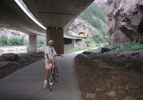 |
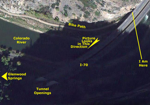 |
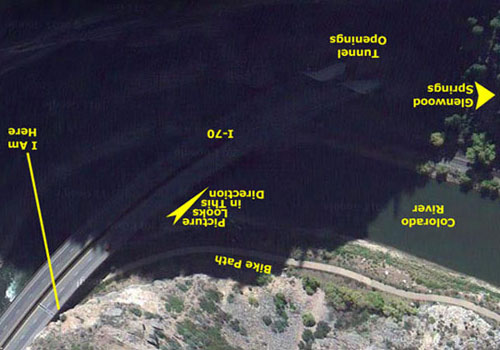
If that explanation doesn't make it clear how the photo matches with the aerial view, perhaps it will help if I orient the aerial view to match the picture (by inverting it):
|
 |
Anyway, that's fun with the Internet!
You can return to today's index
or continue with the next section below.
We Camp on the Colorado River
|
There were also some small cabins like from an old trailer court. There weren't many of them; people without RVs or tents would more logically stay at one of the motels along the Interstate (although there weren't many that were situated right by the river except in downtown Glenwood Springs.
|
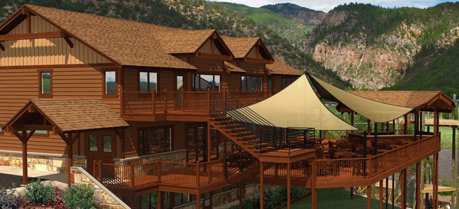
When I went to the website for the campground (to locate the exact address so I could locate it on Google Maps), I found that it has gone downtown and upscale- it is now the Glenwood Canyon Resort. Here is some information from their website:
| "Situated on the banks of the Colorado River, engulfed in the beauty of the spectacular Glenwood Canyon, we invite you to join us for your vacation get-a-way or special event. With a diverse choice of lodging types to meet your every need, a fabulous new event center complete with grand room, meeting facilities and bar & grill, and a number of on-site activities, Glenwood Canyon Resort is your perfect base from which to enjoy a wide range of adventures. In the heart of the Colorado Rocky Mountains between Aspen and Vail, Glenwood Canyon Resort is conveniently located on Interstate 70 just minutes from Glenwood Springs and the World Famous Hot Springs Pool, the very popular Hanging Lake Trail and some of the best skiing in the world. The resort is open year round for you to enjoy all of your favorite seasonal pleasures." |
|
| "We are proud to announce the grand opening of our magnificent ōCanyon Club Event Centerö featuring the ōNo Name Bar and Grillö. The center features event facilities to accommodate reunions, weddings, business meetings, parties and special group events of all kinds. It boasts a 2000 sq. ft. grand room with floor to ceiling doors that open out to a huge outdoor terrace and deck area providing our guests with stunning panoramic views of the surrounding mountain ranges, the famous No Name Arch, and the mighty Colorado River winding through sky high canyon walls. The occupancy for the indoor grand events room is 125 persons, while the main level terrace and bar will accommodate 235. The No Name Bar and Grill features delicious food and a full service bar. These features, along with a full service banquet kitchen, outdoor grill and spacious meeting rooms, enable us to meet all of your needs. It truly is the perfect setting for any group gathering." |
| "The top floor of the Canyon Club is graced with the addition of two brand new and luxurious 2 and 3 bedroom suites. Perched high above the Colorado River with spectacular canyon views, these suites are a very special and convenient accommodation for any group planning an event, reunion, meeting, or wedding, or for a larger family needing extra room and comfort during their stay." |
| "Our selection of accommodations also includes our ōcustomer favoriteö resort cabins which provide enough room and luxury for several guests. For a close to nature experience, you may choose one of our tent sites nestled on the riverbank. Those who prefer a ōsofterö camping experience may find our rustic camper cabins are a great option. RVÆers will delight in the wide selection of sites with full hook-ups and a number of amenities on site to enhance your stay with us. We truly have something to fit everyoneÆs taste and budget." |
| "The resort is the home base for ōRock Gardens Raftingö and ōGlenwood Canyon Zipline Adventuresö, which means you wonÆt need to leave the resort to experience the best recreational activities in the Glenwood Springs area. Whitewater rafting, zipline adventures, high ropes challenge courses, rock climbing wall, mountain biking and gold-medal fly fishing; we have it all right outside your doorstep! The Glenwood Canyon Recreational Trail even runs through the resort with access to several outstanding hiking trails nearby. Whether your stay with us is packed with adventure or planned for relaxation, it is our desire to provide a memorable stay and experience for all our guests. Our friendly and knowledgeable staff is here to help you plan your gathering, event or ultimate vacation." |
You can return to today's index
or use the links below to continue to another photo album page.
|
July 12, 2002: Colorado Trip Day 7 |
|
July 10, 2002: Colorado Trip Day 5 |
|
Return to the Index for Our Colorado Trip |