|
July 17, 2007: New Mexico/Colorado Trip Day 4 |
|
July 15, 2007: New Mexico/Colorado Trip Day 2 |
|
Return to Main Index for New Mexico/Colorado Trip |
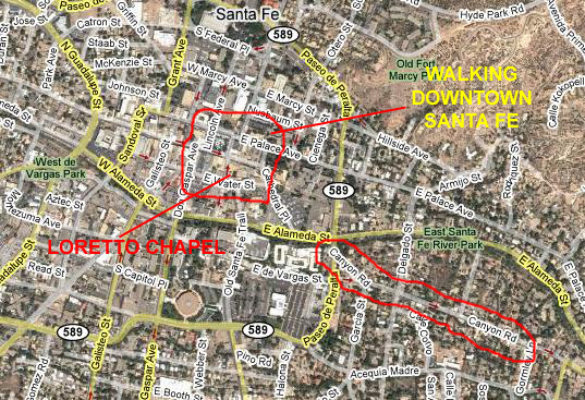 |
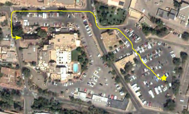
We plan on doing at least three things while we are here, and I've outlined on the hybrid map at left where we'll be in Santa Fe when we do them. First, when we come into town from Cerillos Road, we'll head over to Canyon Road, which is the artist community in Santa Fe. It's filled with shops and studios with all kinds of paintings, sculpture and other artwork. After that, we plan to visit the Loretto Chapel (on the urging of our friend Guy Blair) to see the "miraculous stairway." Finally, we'll probably walk around downtown to see what's changed since we were last here.
Walking Canyon Road in Santa Fe
 |
The last time Fred and I were here in Santa Fe was about five years ago, when we were here with Ron and Prudence Ruckman. That was the infamous trip where Ron tripped and fell on a hike and almost sliced his ear off. We got him patched up in Los Alamos, and then the four of us stayed at Casa Bonito, a very nice B&B just about six blocks from Canyon Road where we are now. While Fred and I aren't the decorative arts mavens that Prudence is, it is still enjoyable to look at the very wide variety of all kinds of artwork that are on display and for sale along this particular street. Much of the work is done by local or New Mexico artists, although we did find lots of stuff brought in from all over the West and indeed from around the world.
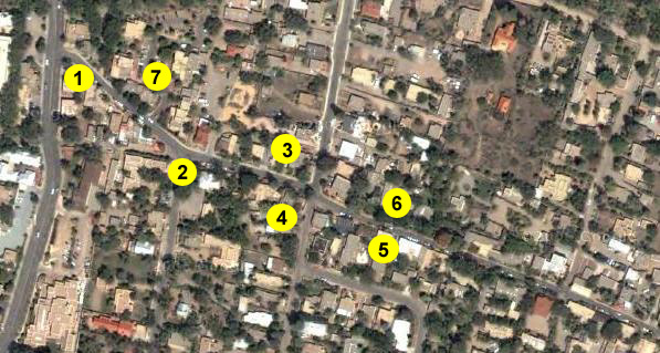
We parked the car at the foot of Canyon Road (1), and started heading up the street to see what we could see. The first series of pictures I've picked out for this album were taken on the south side of the street in the first two blocks of our walk (2). Mostly, we were inside shops, but Fred found some floral subjects for photos, and I found some interesting and beautiful sculpture pieces- including a sparkling glass cube that I would love to have if I had a good place to put it. It belongs outside, where the sun can play off the cube's surfaces and interior imperfections. Here are thumbnails for the pictures I've selected; to see the full-size image, just click on its thumbnail:
|
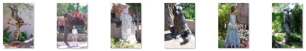
Over on the other side of the street (3) we found that almost all the galleries and workshops seemed to be all about sculpture, and most of them produced sculpture intended to be placed outside, in gardens or other areas. There was an extremely wide variety of this sculpture, and I've selected six of the best examples to show you here. There are thumbnails for these six pictures below; to view a full-size image, just click on its thumbnail:
|
At the end of this block, I got out in the intersection to show you a view of west Canyon Road.
 |
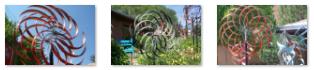
But that's not all. Because the vanes are concave, they will temporarily hold water. A number of the mobiles had water sources attached and, as the water fell into the vanes, its weight causes the sculpture to turn depending on where the water hits. Then, as the water flows down the inside of each vane and out the tip, it acts like a tiny jet, again forcing the vane to turn in the opposite direction. The bearings are designed to offer very little friction, so it doesn't take either much wind or much falling water to cause the mobiles to move.
|
|
|
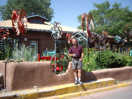
While Fred was talking with the owner of the Waxlander Gallery about the mobiles, I stepped across the street to the a picture looking back the way we had come along Canyon Road.
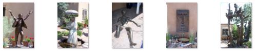
Leaving the Waxlander Gallery, we continued walking up Canyon Road (5 and 6), stopping in a few of the galleries but mostly just taking pictures of interesting objects of art all along the way, on both sides of the street. Some sculptures, like this fellow, were really far out, but most of the sculptures (and there were a lot of them) were really quite nice. There were also fountains and other objects, all of which were interesting, and we took lots of pictures. I've selected some of the pictures that are especially interesting, and I have put thumbnails for them below. To view any full-size image, just click on its thumbnail:
|
While most of what we saw along Canyon Road involved art objects, Fred also took some interesting pictures of some of the flora that was profuse in front of the shops and along the street. You can see three of the best of these pictures here, here and here.
 |
Then we went across the street to a rather odd store for Canyon Road- a bookshop. While it was a specialty bookstore, it was the sculpture outside that was the real attraction. Right outside the main entrance was a bronze boy with books. Around the corner of the building was a unique archway sculpted into bronze books. Through the archway was a really beautiful sculpture garden, full of sculpted children all with a "learning" theme. Finally, just outside this garden we found an incredible sculpture of an Indian maiden. The interesting thing about this sculpture was that it wasn't "bare," but there was sculpted clothing as well, and the entire sculpture was realistically painted. Both the pictures that Fred took of this particular sculpture were really great, and you can see those pictures by clicking here and here.
This stop completed our walk along Canyon Road. The next stop today is going to be in downtown Santa Fe, so we got back in the car and drove the few blocks to downtown.
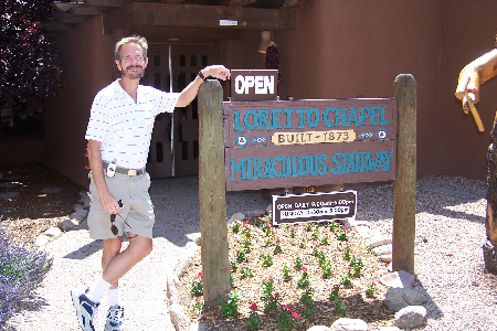
Loretto Chapel in Santa Fe
 |
Loretto Chapel was the first Gothic building west of the Mississippi. It was patterned after Sainte Chapelle in Paris, and it was built at the request of Archbishop Jean Baptiste Lamy between 1873 and 1878.
The church itself is not very remarkable, except for its status as being the first of its type in the entire Western United States. The Chapel is best known for its choir loft staircase, called "miraculous" due to its two complete spirals without center or side supports (defying engineering logic) and due to the legend of its construction.
When the Loretto Chapel was completed in 1898, there was no way to access the choir loft twenty-two feet above. Carpenters were called in to address the problem but they all concluded access to the loft would have to be via ladder as a staircase would interfere with the interior space of the small Chapel.
Legend says that to find a solution to the seating problem, the Sisters of the Chapel made a novena to St. Joseph, the patron saint of carpenters. On the ninth and final day of prayer, a man appeared at the Chapel with a donkey and a toolbox looking for work. Months later the elegant circular staircase was completed, and the carpenter disappeared without pay or thanks. After searching for the man (an ad even ran in the local newspaper) and finding no trace of him, some concluded that he was St. Joseph himself, who came in answer to the sisters' prayers.
The stairway's carpenter, whoever he was, built a magnificent structure. The design was innovative for the time and some of the design considerations still perplex experts today. The staircase has two 360 degree turns and has no visible means of support. Also, it is said that the staircase was built without nails�only wooden pegs. Questions also surround the number of stair risers compared to the height of the choir loft and about the types of wood and other materials used in the stairway's construction.
 |
But really, the way to experience the Loretto Chapel is through the movies the two of us took. All of them are pretty good and will give you an excellent impression of being there. First, Fred made an excellent movie capturing the stairway and chapel, and you can watch that movie with the player below:
|
|
I made two movies in the chapel. First, I made a movie just to show the stairway and choir loft, and then I made one more movie, taking advantage of the narration playing in the background, of the stairway and chapel. You can watch both of these movies using the players below:
|
|
The chapel was quite an experience, and not just a little bit inspirational, but we had other things to see and do today. One unscheduled stop was the craft fair going on right next to the church in its garden area. Then, it was off to the main square.
Walking Downtown Santa Fe
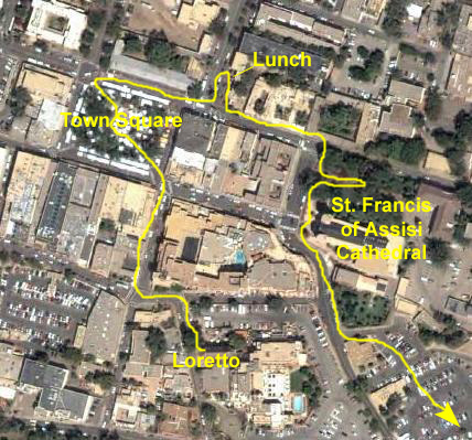 |
On the street leading from Loretto to the town square, there were a number of indoor and outdoor shops selling all manner of things- from strands of hot peppers to sculpture to artwork to furniture and, particularly, colorful blankets. There were many beautiful things, but most of them require a home done in "Santa Fe Style" to display them properly, so all we did was look.
In the town square, there were lots of people sitting in the sunshine around the central monument dedicated to the founding of Santa Fe, many of them eating lunch purchased from one of the many vendors lining the square. We walked up the side of the square, though, to a small restaurant off on a side street- one that we'd eaten at before when we were here last with Ron and Prudence. They served lots of different stuff, but I had my usual lunch. After lunch, we stopped at the corner where there was a sculpture that was particularly photogenic. We'd seen this sculpture before, and I recall that there is a picture of Fred standing with it earlier in this photo album; this time, Fred captured the sculpture and I.
|
|
Right next to the park, of course, is The Cathedral Basilica of St. Francis of Assisi- the large central church in town and one of the oldest in the area. Even though it is the oldest, of course, that doesn't mean that it hasn't had to keep up with the times, as the signs out front indicate. We walked along the sidewalk from the park in front of the Cathedral, and Fred took a movie of the Cathedral as we walked along (watch it with the player at right). The Cathedral is a handsome one, although not so large as many you might see in large urban areas with large Catholic populations. It is, as its name indicates, dedicated to St. Francis of Assisi, and his statue is in front of the church near the street.
As we walked around the church, Fred was intrigued by the many distinctive architectural elements- the columns, pediments, arches and so on- and he took a number of pictures of these elements. If you are interested in them as well, just click on the thumbnails below to view the best of the images Fred took of this beautiful church:
|
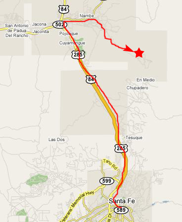
The Cathedral Basilica was our last stop on our tour around downtown Santa Fe. On the way back to the parking lot, Fred got a picture of one of the oldest hotels in the downtown area- The Inn at Santa Fe. He was especially interest in how a climbing vine had spread across the adobe walls of the hotels, so he had me go across the street for a picture of the corner of the hotel. He found that same vine covering a wall closer to the parking lot, and the vine sported bright red flowers. Pretty soon, we were back at the parking lot, and we headed off to leave Santa Fe and visit our next stop- Nambe Falls.
Nambe Falls Hike
 |
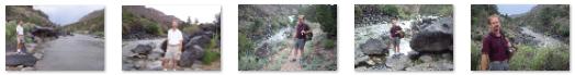
After a couple more miles, we reached the parking area for the falls, got our stuff together, and headed off to the trail. Just after the parking area, the trail crosses the stream that is created below Nambe Falls, and we stopped momentarily to take a couple of pictures- one of me on the bridge across the stream and one of Fred on the bridge.
The trail then began a series of switchbacks up the hillside. The distance wasn't all that great, nor was the height gain, and the entire trip to the viewing area only took about twenty minutes.
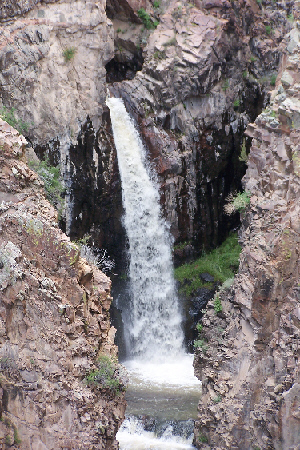 |
Although the trail officially ended at the overlook where we were standing, a less-used but still pretty obvious route led further up the hillside. Before taking off up that trail, both Fred and I scrambled up just a ways above the overlook to get some pictures, two of which I've included here. There is one of Fred and Nambe Falls and one of me and the falls.
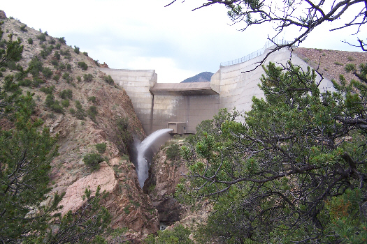
Before we headed off a little higher, I made a movie of Nambe Falls, showing the reservoir and the falls. You can watch it using the player below:
|
|
So, we left the overlook and climbed up another hundred feet or so to get a better view.
 |
The top of the ridge also offered an excellent view back across the high desert to the northwest- out across the parking area and in the general direction that we'd be going once we leave the falls.
Right about this time a light rain began, so, having seen what we'd come for, we set off back down this different trail. As we suspected, it lead back to a fork in our original trail- a fork we'd missed on the way up.
When we got back to the parking area, we saw that there was a short trail that led up along the stream, so we followed it for a couple hundred feet or so. The easy part of the trail ended at a canopied sitting area, and we stopped here. We thought the area worth a couple of pictures, and so you can view one of Fred and one of myself.
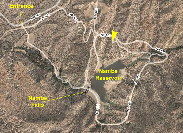 |
There were quite a few roads around the reservoir; it is apparently heavily used at times by fishermen and boaters or just by folks wanting an afternoon at the lake. After driving around for a bit, we headed back out to the highway for our drive further north.
Driving to Wild Rivers Recreation Area
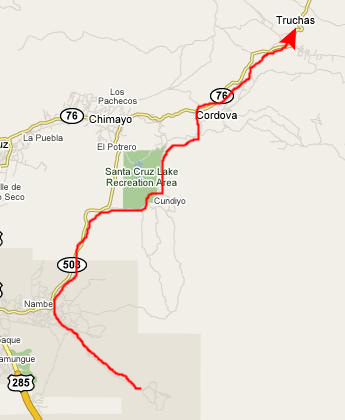 |
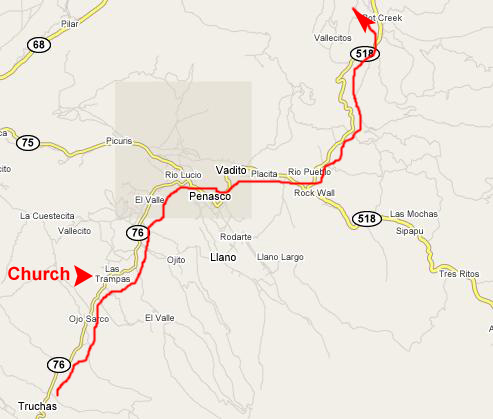
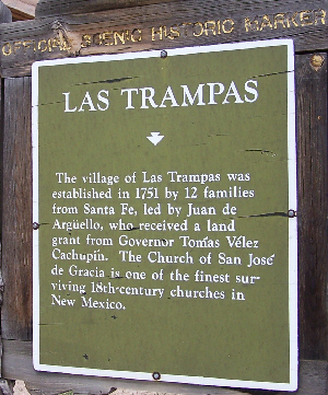
We even saw on the New Mexico map that there was a scenic highway that lead around the Santa Cruz Recreation Area through the tiny town of Cundiyo, and so we followed that road. We ran in and out of rain showers, reaching the small town of Truchas in mid-afternoon.
Continuing north, the high desert seemed to give way to greener pastures and small farms, and the drive was very pleasant. The road wasn't a major one, and there wasn't a lot of traffic, and that made the drive easier.
 |
|
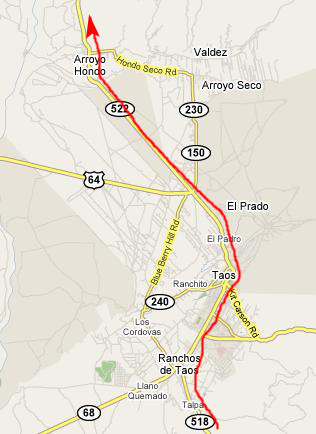
Leaving Las Trampas, we continued north towards Taos. The road got busier, and there were quite a few heavy rain showers. But when they cleared, we were offered beautiful views of the mountains near Taos.
 |
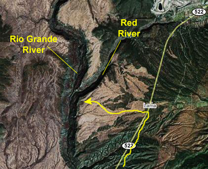 |
We drove through Taos, but didn't stop at the Pueblo since we'd been there before. We headed up Route 522, turning off on a dirt road just south of Lama, NM. This road lead out to the Wild Rivers Campground- our destination for the day.
Hiking Down to the Rio Grande
 |
From the top of the cliff, a trail leads down to the river. The hike is about a mile and a half, and very steep for the first two-thirds of it. From the top of the cliff, the Rio Grande looks really small (even though it IS pretty narrow this far north). We started off on the hike, with Fred leading the way down the trail. We both took some pictures on the way down the trail, but most of them were too dark to include here. But when we got down toward the bottom of the trail and the Rio Grande River itself, the skies brightened up quite a bit, and we got some pretty good pictures.
Down towards the river, the trail led along the river for a ways until it finally dropped down to the side of the river. Here, we took some pictures of the scenery around the Rio Grande, and I've put thumbnails for these pictures below. To see a full-size image, just click on its thumbnail:
|
|
|
On the island, we found a hiker's shelter and some other viewpoints, but when we found some trail markers, Fred corrected my misapprehension. What I thought was a confluence of branches of the same river was actually the point where the Rio Grande comes together with the Red River coming out of northeastern New Mexico. (This is not the same "Red River" that forms part of the border between Oklahoma and Texas.) The footbridge was actually across the Red River only. Unfortunately, I'd already taken my movie of the Rio Grande, in which I erroneously refer to "branches" of the Rio Grande. You can watch this movie with the player at right.
The hike was really interesting and, even though the skies were kind of dark and threatening, the scenery was beautiful. But we knew that if we were going to set up the tent we'd need to do so soon, so we headed back up the trail. As you would suspect, it took longer going up than coming down, but we reached the top in plenty of time to have another debate about whether or not to set up the tent. It wasn't that one of us wanted to and the other didn't; we were both unsure as to whether we might get rained out when we tried to fix dinner. But, in the end, we decided to go ahead and camp and take our chances. As luck would have it, aside from some thunder and a quick sprinkle or two, the rain left us alone. Fred was able to cook while I set up the tent. We had a good dinner, downloaded the days pictures to the computer and looked at them, and then had an uneventful night.
You can use the links below to continue to another photo album page.
|
July 17, 2007: New Mexico/Colorado Trip Day 4 |
|
July 15, 2007: New Mexico/Colorado Trip Day 2 |
|
Return to Main Index for New Mexico/Colorado Trip |