|
July 20, 2007: New Mexico/Colorado Trip Day 7 |
|
July 18, 2007: New Mexico/Colorado Trip Day 5 |
|
Return to Main Index for New Mexico/Colorado Trip |
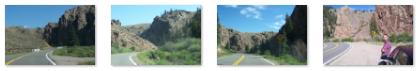
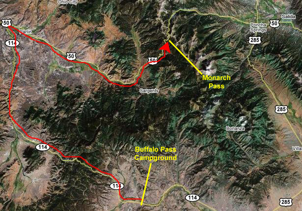
Driving to Monarch Pass
 |
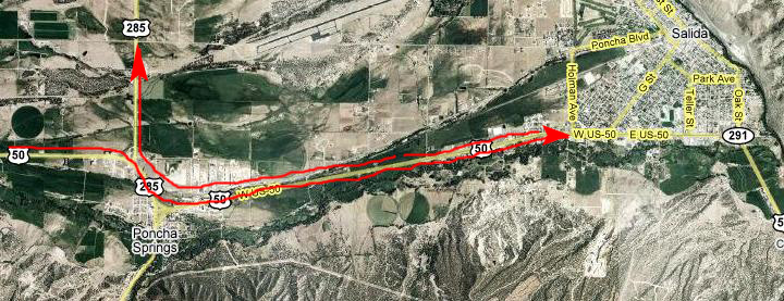
We took down the tent, got our morning routine done, and headed northwest along Highway 114. We could have gone back through Saguache, but we had read that the highway between our campground and Highway 50, and then Highway 50 through the mountains was very scenic.
 |
Below are some thumbnails for more of the pictures we took along this first stretch; just click on them to view the full-size pictures:
|
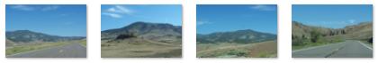
Once through the pass, the land began to level out, and turned for a while into high desert hills. There are some thumbnails for a few pictures of this stretch along Highway 114 below; just click on them to view the full-size pictures:
|
As we got closer to Highway 50, we began to see wide expanses of farmland. This was another of those areas that made us think about how people could basically be self-sufficient. There was adequate water in the stream that was running through the valleys, and the land seemed able to support a wide range of agriculture. There were many animals of various kinds, and some of the farms even had their own windmills or other power sources, it seemed. It reminded us of the valleys in south central Montana that we'd seen last year, and prompted more conversation about what might happen if things really fell apart in the future.
When we reached Highway 50, we turned east again and after about forty miles began to climb steadily into the Rocky Mountains. After a long, long period of ascending steadily, we rounded the last curve and could see ahead the transmission towers just above Monarch Pass.
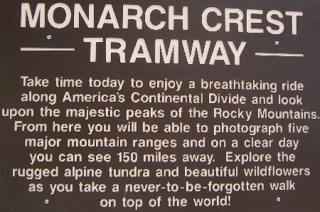
Monarch Pass, Colorado
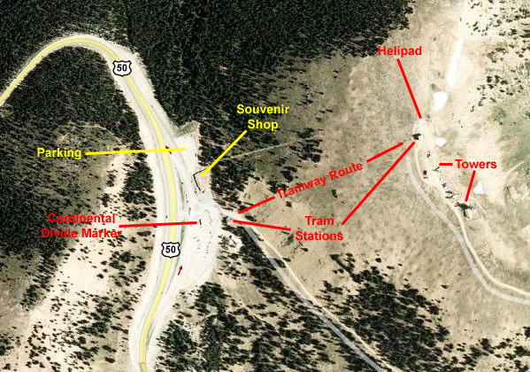 |
After we looked around in the shops for a while (where we actually found some pretty neat stuff to get and put aside for Christmas), we wandered outside. In the middle of the main parking area were a large number of bicyclists who, we learned, were biking from Connecticut to California, in 50-mile-a-day legs with all their support vehicles and stuff trailing along with them. There appeared to be thirty or forty people, some of whom we saw at the top of the mountain behind the pass.
 |
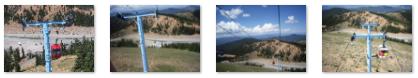
From inside the tramway cars, we got some great views. Of course, we each had to take a picture of the other riding in the car, so here's me and here's Fred. As we ascended, other gondolas passed us going in the other direction, of course, but mainly we just admired the views, as in this case looking north across the Rocky Mountains and some mountain thunderstorms.
I have to admit that the first part of the tram ride was a little unnerving. I kept having visions of our gondola breaking away from the cable and falling the thirty or forty feet to the hillside below. But that wouldn't have been the worst part- it would then have bounced and rolled hundreds of feet back down the hillside and, undoubtedly, across the parking lot and road, and would have come to rest against one of the hills opposite. But after a little while on the tram, the feeling disappeared, and we were both able to appreciate the ride. Below are thumbnails for four pictures we took as we ascended the tramway; click on them to view the full-size pictures:
|
We got off the tramway at the station at the top, and went right outside to wander around and take pictures. One of the first things both of us did was to take a panoramic movie; if anyplace called for one it was this place. Take a minute or to and orient yourself by watching Fred's movie and (turning your sound down a bit) my movie of the scenery at the top of the mountain using the players below:
|
|
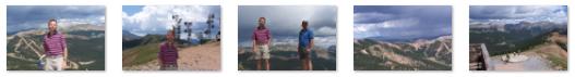
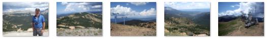
Most of the pictures that we took here at the top of the mountain don't require much description from me here. There are views of the mountains and the ski area to the north, the transmission towers south of the station as well as the mountain valleys to the east. Some of our pictures were taken from the station balcony and some were taken from the mountaintop outside. Below are thumbnails for ten of the best pictures we took here; the first five were taken by Fred and the second five by me. There's some duplication, but I think all of them are good, so click on as many of them as you wish to view the full-size picture:
|
After spending quite a bit of time at the top of the mountain, we caught another gondola and headed back down to the tram station, and took another couple of pictures of it, one with Fred and one with me. We headed down the walkway to the main parking area and headed out to the middle of it where the marker denoting the continental divide was placed. This was our third crossing of the divide on this trip, and as usual we wanted to record the event, so here is Fred at the continental divide, and here is a picture of me at the divide.
We'd spent quite some time here at Monarch Pass, but it was well worth it- for a number of reasons. But now, it was time to head on down the road to see if we could find a spot to have lunch.
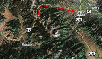
Driving to the Difficult Campground near Aspen
 |
 |
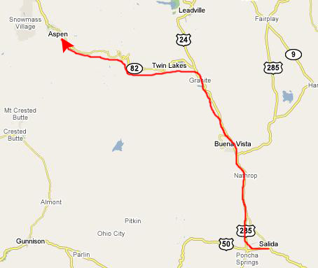 |
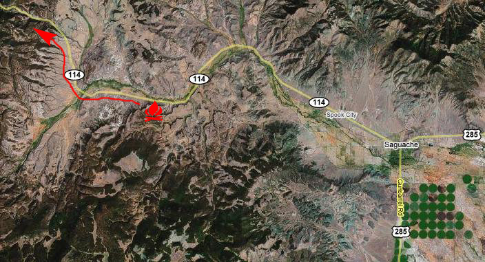
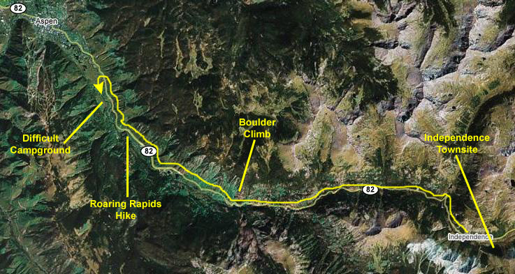
So, what we decided to do was go back through Poncha Springs, take Highway 285 to the point where US 24 branched off, continue north on that, and then take the very scenic Highway 82 over to Aspen. I've marked the route on the map at the left.
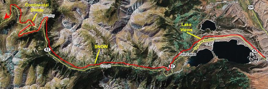
As we drove up US 285, and then US 24, there was a lot of rain, and there were dark clouds hugging the mountains off to the west, which was the direction we would be heading, and also up ahead to the north. Aspen was about two hours away over the mountains, and we just hoped that perhaps the weather would be better once we got there, since we wanted very much to camp out in one of the campgrounds we'd read about ahead of time.
 |
|
|
|
|
Leaving Independence Pass, we continued west on Colorado 82, this time steadily descending. After just a few miles of driving, we stopped and, through a break in the drizzle, got an excellent view of the highway behind us. Ahead was Aspen and the campground we wanted to use.
As we drove down Highway 82 towards Aspen, we passed a number of sites that we thought we'd want to explore, including an old ghost town, a hike along the stream that was paralleling us and a large rock outcropping that looked as if it would be interesting to climb. But we wanted to get situated for the night, first, whether that was going to be in a campground (pretty iffy given the weather) or a motel. So we headed on in to Aspen and stopped first at the campground we'd been planning on- The Difficult Campground (so named because of the river flowing right by it). When we got to the campground, it seemed as if the rain was tapering off and so, even though the weather still wasn't very good, we went ahead and set up the tent in a site quite near the Difficult River, so that, later if it was raining again, the tent would be ready. Even though we probably wouldn't be able to cook, at least our tent was secured.
Once that was done, we decided to go back up the highway about ten miles to the ghost town, look around there, and then work our way back towards Aspen, doing whatever hikes and climbs the weather would allow.
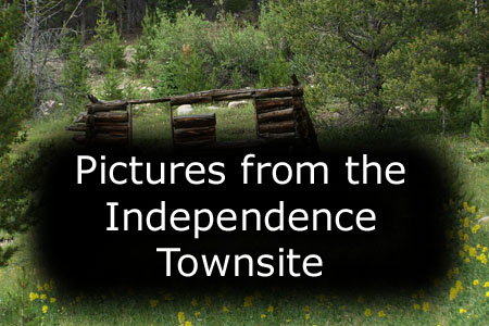
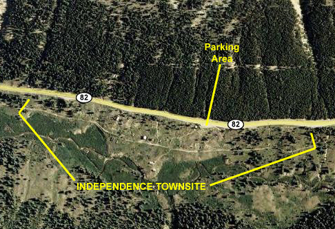
Exploring the Independence Townsite
 |
 |
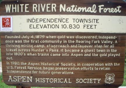
There were a few signs at the parking area when we arrived, one of which is shown above. The other, which had some pictures of how the buildings looked over a hundred years ago, had the story of Independence, but the type was too small for us to take a good picture that could be shown here. So, here is one of the pictures from the sign, and a copy of the text accompanying it:
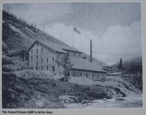 |
By 1881 the Farwell Mining Company was operating the Stamp Mill and a large sawmill for the site's mines and by that summer the population had grown to 500, served by four grocery stores, four boarding houses and three saloons. By 1882 the Town of Independence had over 40 businesses with three post offices and an estimated population of 1,500 people.
But prosperity ws not to continue. Aspen, established at the same time as Independence, won the honor of county seat for the newly christened Pitkin County in 1881. Miners were lured away from Independence by the abundant work, good pay and milder climate of Aspen. Mining at Independence proved to be short lived. Over $190,000 worth of gold was produced between 1881 and 1882 by the mines of Independence. The next year production had dropped to $2000. By 1888, only 100 citizens remained in the high mountain town, which in its brief history had been called by many names- Independence, Chipeta, Mammouth City, Mount Hope, Farwell and Sparkill.
From the parking area, we got our first view of the Independence Townsite spread out in the valley below us. Way across the valley, we could see what the residents of Independence must have seen- a small mountain stream that might have provided some of the water for the town. And, again from the parking area, Fred tried out getting a closeup view of some of the buildings across the valley.
One of the first buildings that we came to was actually occupied. There was a young fellow inside, and his bicycle was leaning against the main building. The house itself had been restored and was apparently being kept up (all in the style it must have had at the turn of the century). Other than the fact that there was a mailbox and a notice that the building was being occupied, there was little to indicate that- aside from the new hinges for the windows and doors. There was an outhouse in the back that you can see in one of the thumbnail pictures below. As we followed the pathways between buildings, we found that some of the structures had signs indicating what they had been, since there was not much left to indicate what the purpose of many of the structures was. For example, one of the collapsed structures was T.B. Conner's Boarding House and another was Ted Ackerman's Hotel.
|
Independence Townsite was very interesting, and a break in the weather allowed us to wander around and see all of it. We took lots of pictures in addition to the ones mentioned in the narrative above and, even though you might not want to see all of them, I've put the best of them into a slideshow so you can look through them easily.
To view the slideshow, just click on the image at right and I will open the slideshow in a new window. In the slideshow, you can use the little arrows in the lower corners of each image to move from one to the next, and the index numbers in the upper left of each image will tell you where you are in the series. When you are finished looking at the pictures, just close the popup window.
Our last view before we left the Independence Townsite was the same one that townspeople must have enjoyed when they lived here- the view down the valley towards Aspen. Independence was certainly in a picturesque place, but, once the gold ran out, there was really little to support a town, since it was so far up the valley. Perhaps if the residents had been able to hang on for 75 years until skiing became a multi-million dollar activity, things would have turned out differently.
Hiking in Roaring Gap
Leaving Independence Townsite, we headed west along the highway towards Aspen, enjoying the scenery along the twisting highway as it hugged the sheer rock walls of the mountains. At a couple of points, we stopped to admire the valley view, and there were a couple of times that Fred got some pictures of interesting flora, pictures that you can view here and here.
As we drove down the highway from Independence, we came to a point where the road had to make a sharp curve around a pile of bare boulders, and they looked so inviting that we stopped and parked the car at the base and went climbing up on the rocks. The area wasn't nearly as extensive as, say, Mt. Scott in the Wichitas, but it was fun to get just a bit of exercise bouldering around on the rocks. At one point, Fred took a picture of the (and look at this upcoming picture carefully to see what you can see) rock face above us and, being more observant than I, took another shot of the same rock face, but this time with the closeup lens, capturing the rock climber that I had completely missed.
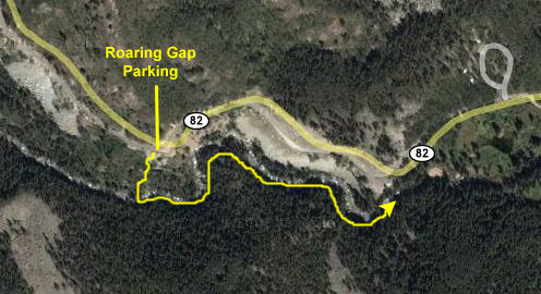 |
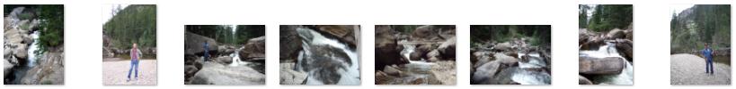
Eventually, we reached the end of the trail, about a half mile from where we'd crossed the bridge. It was a pleasant though not strenuous walk; rivers and streams are always enjoyable hiking companions. We took a number of other pictures that you might find interesting, and thumbnails for some of them are below. You can view the full-size picture by clicking on the thumbnail:
|
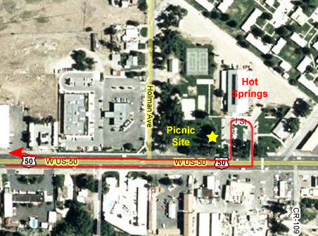
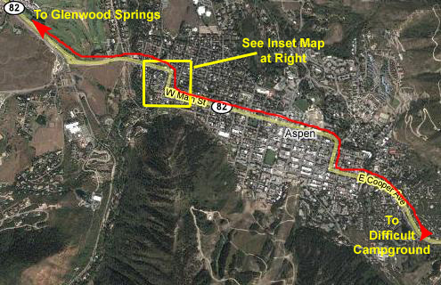
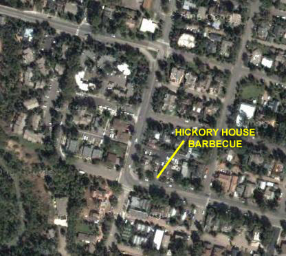
After our hike, we headed back to the campground where we'd set up the tent. When we got there, it was misting and drizzling, so we reluctantly had to give up on the idea of cooking at the campsite and we headed into Aspen. We pretty quickly found that Aspen has done an excellent job of keeping out just about every chain restaurant there is, and the ones that may be there have to abide by all kinds of sign and location restrictions, which made them difficult, if not impossible, to find. We drove all over town, and even a ways out towards Glenwood Springs without finding anything, so we had to return to town and stop at a couple of places to ask. Finally, we got a recommendation for a place we'd passed but missed- no big sign. It was the Hickory House BBQ, and it turned out to be really great. Everything we were looking for, and good, strong and endless iced tea. The aerial views below will show you the Aspen area, the route we traveled through it looking for a place to eat and, in the inset, the Hickory House BBQ.
 |
 |
You can use the links below to continue to another photo album page.
|
July 20, 2007: New Mexico/Colorado Trip Day 7 |
|
July 18, 2007: New Mexico/Colorado Trip Day 5 |
|
Return to Main Index for New Mexico/Colorado Trip |