|
July 21, 2007: New Mexico/Colorado Trip Day 8 |
|
July 19, 2007: New Mexico/Colorado Trip Day 6 |
|
Return to Main Index for New Mexico/Colorado Trip |
Hiking Above Aspen, Colorado
When we arose in the morning, the rain had stopped, and we found that not much had really come into the tent. Most everything was wet, though, but that wasn't a particular problem as we'd assumed this would be our last night camping. So we just cleaned everything as best we could, folded it up and put it away. I planned to let everything dry out in my garage at home, and also have the sleeping bag cleaned and ready for our next trip.
|
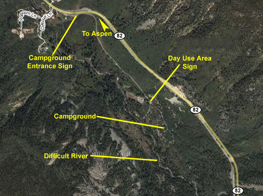
The actual campground entrance sign was actually located up near the highway, right at the beginning of the half-mile entrance road.
 |
|
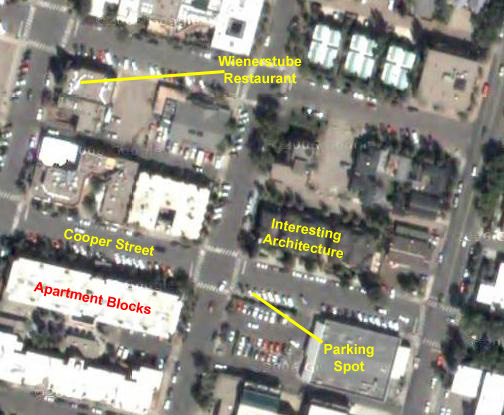
Right across Cooper Street from where we parked, there was some interesting, typical Aspen architecture that I thought was worth a picture, and, looking down Cooper Street you can see some typical apartment buildings for the town and the mountains behind. All through breakfast, I was wondering if we could get up into those hills to view Aspen from above, and I made some inquiries at the restaurant, finding out that we could.
It was a two-block walk to the restaurant, the Wienerstube, which, as would be obvious from its name, was a German place, but one that served very good, and quite famous for Aspen, breakfasts. Fred and I shared an omelet and some unusual oatmeal pancakes. On the way out, we found out that at least one other famous person had "discovered" the Wienerstube!
|
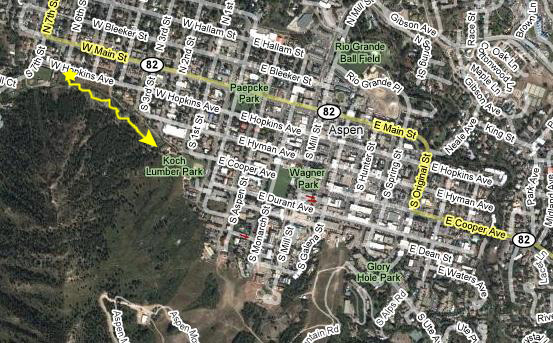
We took a lot of pictures on this hike, most of them of downtown Aspen, but let's just take a look at the best of them. Just a few hundred feet up the trail, vistas began to open up, like this one, looking east along Cooper Avenue, or this one, looking eastward along the mountains south of Aspen. This last view actually looks directly back in the direction of Highway 82 and the campsite. As we climbed higher, we got better and better views of the town, and the trail curved so that we could look northward across town to mountains on the opposite side. Take a look at two of the best views in this direction here and here. And here is a view that I took looking northeast across Aspen.
|
|
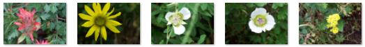
I didn't notice until we downloaded our pictures that Fred had also been taking some excellent pictures of flora, and I've put thumbnails for five of the best of these below. Just click on the thumbnail to view the full-size picture:
|
As we were leaving Aspen after our hike, Fred took a couple of interesting pictures from the car. One was of a typical storefront downtown and the other was of two of the large homes that were perched on the hillsides just northwest of town. Then it was about an hour up the road to Glenwood Springs.
In Glenwood Springs, Colorado
|
|
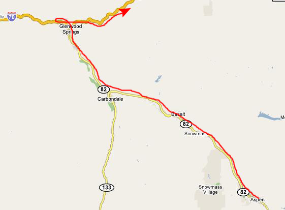
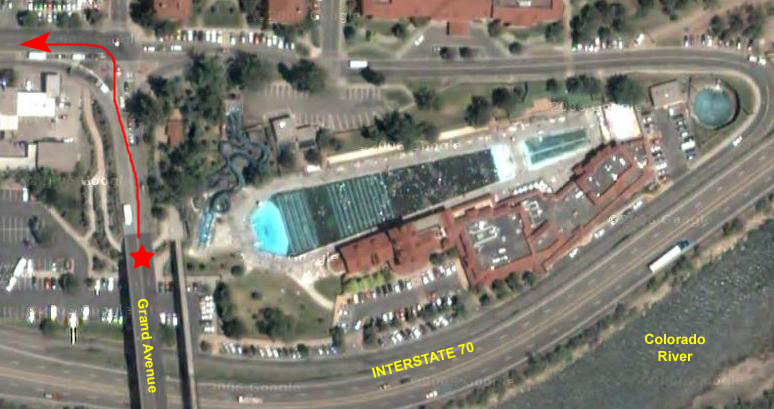
To get on I-70 heading east, we had to make a circle around to the west, but before we got on the highway, we thought it would be best, since it was Friday night, to stop and make a hotel reservation for someplace near Breckenridge, where we planned to do a couple of hikes. We couldn't find any of our familiar chains, so I stopped at a Holiday Inn to use the Internet access in their lobby to search for hotels online. After a good deal of searching, I located the Arapahoe Inn in Keystone, Colorado, another ski area about six or eight miles from Breckenridge. It was the most reasonable hotel in the area. So I made us a reservation and we left Glenwood Springs heading east on I-70.
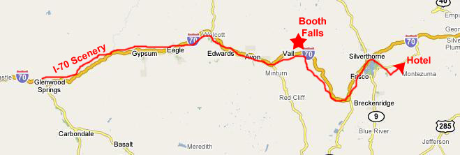
Driving I-70 Along the Colorado River
|
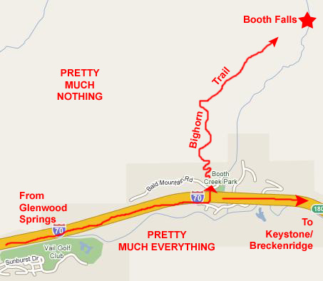
After we do the Booth Falls hike, we'll probably be ready for the hotel, which will be in the ski area of Keystone, Colorado, an area about eight miles west of Breckenridge and Dillon.
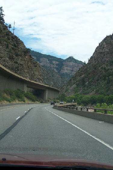
But first, we'll be driving through some incredible scenery as Interstate 70 winds through the Colorado River gorge east of Glenwood Springs.
|
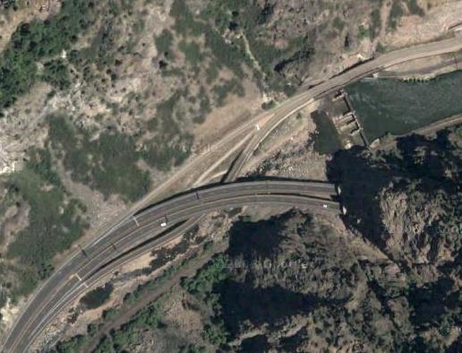
The Colorado River has not left any flat land on its south flank through this area, and precious little on its north side, but this is the only feasible route for the interstate highway to take. This stretch was one of the last sections that was completed on the Interstate Highway System- about twenty-five years before the first sections were constructed during the Eisenhower Administration. It was difficult since there was so little real estate to work with. I'm told that typical interstate highway built in rural areas on level ground is about two million dollars a mile; by contrast, I read that this section of highway cost five times that much, which means that the thirty-mile stretch cost close to a quarter billion dollars (in today's terms).
The highway is multi-level along almost this entire stretch. The westbound lanes are on the upper level, and all the exits have to be built in a much more complicated fashion to deal with the change in level between the two sides of the highway. There are number of tunnels along this stretch of highway, and for the tunnels, the roadways had to be brought to the same level. This was usually done by crossing the Colorado and using the bridges to bring the highways level, although in a couple of cases major excavation had to be done to keep the roadways and tunnel on the same side of the gorge.
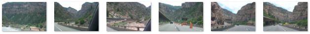
The Colorado River is your constant companion as you drive through the gorge, and often you can see rafters or kayakers on the river, as we did today. We have driven along here when the river was relatively calm, but these times are rare. Now, in July, there is still a lot of runoff from snowmelt, and so the river is high, fast-moving, and turbulent.
|
|
|
Fred took a number of excellent pictures of the highway and the scenery as we drove along, and I have put thumbnails for six of the best of them below. To view the full-size pictures, just click on the thumbnails:
|
|
|
As the gorge widened out, the highway flattened out, and in the space of another two or three miles was much like any other interstate. We drove and admired the scenery until we reached the exit for our next hike.
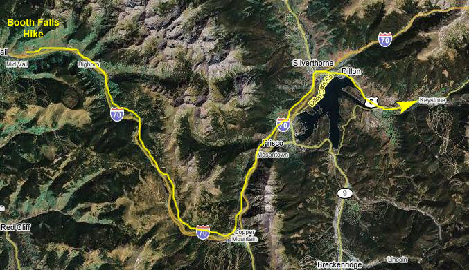
Hiking the Bighorn Creek Trail
|
We climbed up the hillside in front of the cars to the trailhead and we headed off up the steep first part of the trail. After only an eighth of a mile of very steep ascent, we could look back and see the valley and some of the condominiums in East Vail. I can only imagine that this entire area is covered with lots of snow in the winter.
After climbing steeply for a while, the trail leveled off and crossed through some light forest and then across a couple of high meadows. Then, it reached one of the highlights of the hike- an aspen forest. The forest was quite beautiful, with aspen as far as you could see. It reminded me of nothing so much as one of those paintings by Bev Doolittle. To give you a sense of scale, here is a picture I took of Fred in the aspen grove.
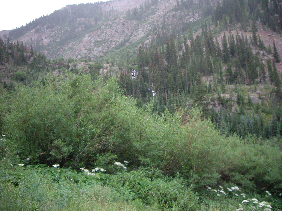
It was here that the wisdom of bringing our umbrellas became evident, as it started to rain lightly. So we continued up the trail through the aspen forest. We continued walking up the trail in the light rain and, at one point, Fred spotted a visitor way off to our right. While we were actually some distance away, the deer was still wary. Another half-mile up the trail brought us to the side of Booth Creek, and we thought this meant that we were near the falls. But it was just a point where the trail dipped down to the creek, and soon we were ascending again. We passed through an area of rocks and ferns, and there were also a number of places where small springs or streamlets crossed over the trail, and we had to tread carefully to cross the muddy areas (and were not always entirely successful in staying out of them).
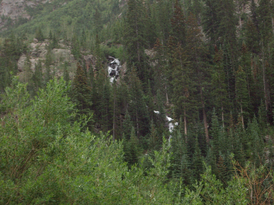
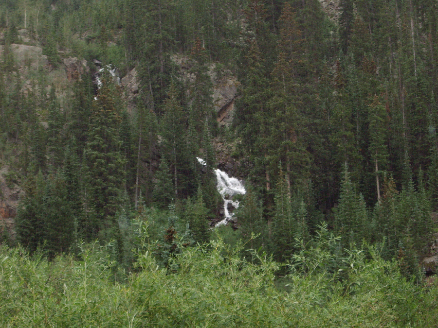
Our goal for this hike, of course, was to reach Booth Falls and, eventually, we came in sight of it. We knew that we would have to forge our own trail to get over to it but we also knew that, due to the steady light rain, we'd inevitably get soaked working our way through the meadow and the brush. So, we settled for some pictures of the falls, and I've put thumbnails for the three best ones below. Just click on the thumbnail to view the full-size picture:
 |
 |
 |
We looked at the falls from a distance for a while, and then headed back down the trail, continuing trying to stay relatively dry. Again, we were only moderately successful. When we came out in the meadow above the first steep part of the trail, I took a picture of the East Vail valley, and when we reached the parking area again, I had Fred point to our hike on the map.
Although it rained, we enjoyed the hike. Even so, we were happy to head on over to Breckenridge and Keystone to check into our hotel for the night.
Exploring Keystone, Colorado
 |
The Inn wasn't too busy when we checked in, so we got some ice, hauled out the blender, and sat back relaxing with a couple of frozen margaritas. It was too late in the day to try another hike and, in any case, there wasn't one nearby, so we thought that instead we would get out the frisbee and go find a place to throw it around.
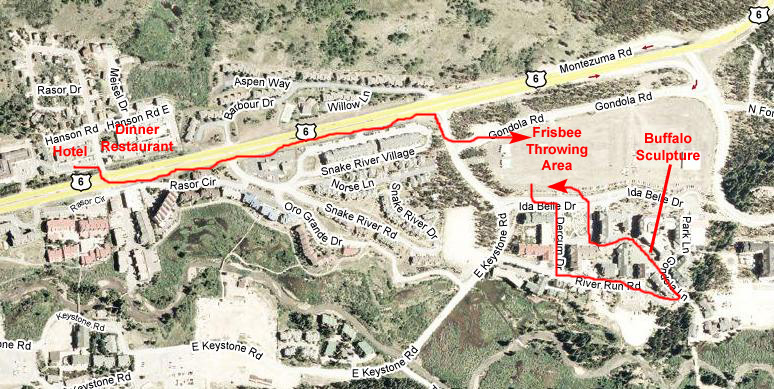 |
When we finished, we thought we would go take a walk through the River Run area, and just drove across the parking lot. I am not familiar with ski areas like this one, but from the signage and stuff it was apparent that these were condos or timeshares in a collection of buildings and with lots of shops and restaurants as well. I am sure it looks entirely different in the winter but now, in the summer, looked just like any other planned condo community. The first thing we ran across were some interesting plantings that Fred wanted to stop and inspect. Then we walked down one of the driveways past some shops and residences, reaching the back of the development in just a couple hundred feet. Then we walked along the back driveway where we could see the actual ski runs over on the hillsides.
Walking further along, we came to the gondola loading area which must be extremely active in the winter but which was now deserted. From that area, we could see some of the shops and restaurants. From the ski lift area, there was a bridge into the development, with quite a few restaurants and bars. From just across the bridge, you could look down the main street of the development.
We walked through the development back towards the car, looking at some of the posted restaurant menus, wondering if we might return for dinner, but didn't find anything particularly enticing. Right in the middle of the main square, we came across a striking buffalo sculpture, and each of us took a picture of the other beside it. Here are those two pictures- the first one of Fred and the second one of the buffalo and I. Finally, from a vantage point near where we parked, we could get a good view of River Run, including a miniature golf course right at the front of the development.
We drove on back to the Arapahoe Inn and got cleaned up, and then went out to look for some dinner. We didn't have to go far, as we had a recommendation for an excellent Mexican restaurant just across the street from the hotel in a strip shopping center. It turned out to be quite good, and we enjoyed it very much. Then it was back to the hotel and a relaxing evening.
You can use the links below to continue to another photo album page.
|
July 21, 2007: New Mexico/Colorado Trip Day 8 |
|
July 19, 2007: New Mexico/Colorado Trip Day 6 |
|
Return to Main Index for New Mexico/Colorado Trip |