


|
November 14, 2009: Puerto Chiapas, Mexico |
|
November 12, 2009: A Sea Day |
|
Return to the Index for Our Panama Canal Cruise |
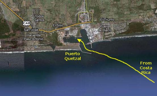
Arriving at Puerto Quetzal, Guatemala
|
There were two port boats nearby, the Hercules and the Poseidon, and it looked as if they were going to guide our ship into the dock.
|
I made this movie just as we'd passed into the harbor, when I thought that we would be docking at the industrial-type docks that were off to our starboard side. |

|
The captain brought the ship into the harbor bow first (heading north, actually), and then he began the slow process of swinging the stern around clockwise, until the Oosterdam was entirely inside the harbor with the bow pointing east. Then he was aligned directionally with the passenger dock, but still a few hundred feet from it and somewhat east of it.
He then slowly backed the ship up while bringing it closer and closer to the dock- easy to do in a twenty-foot power boat but a heck of a lot harder with a thousand-foot ocean liner. But that's exactly what he did. By this time I'd moved over to the port side of the ship and Fred had joined me, so we had a good view of the ship sidling into the dock, the lines getting thrown, and the waiting dockworkers getting the ship safely secured to its moorings. By seven-thirty the docking was complete, and by eight or so the first people were disembarking. Our own excursion to Antigua didn't depart until about nine-thirty, so we had time for breakfast and getting on our walking clothes for the day.
|
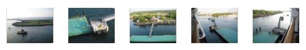
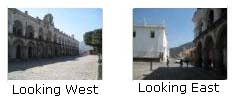
Now that I have gotten my docks straight, I am on the port side of the ship and can show you the actual dock where we will be coming in as well as the area around it. |
We took a few assorted pictures of the dock coming in, the welcome center ashore and the bridge leading to it, the nearby marina and the workers on the dock. If you will click on the thumbnails below, you can have a look at the best of these pictures:
|
The Bus Ride to Antigua
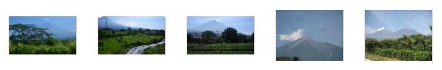
And then we were off. Our tour guide (I have neglected to remember his name) spoke very good English and was very informative as we rode north into the mountains along some rather good highways. The land was pretty flat near the coast, but pretty soon we could see the many volcano cones that dot this part of Guatemala. They were really pretty spectacular. (The volcanoes are all dormant, but there are earthquakes from time to time, so I suppose that they could always come back to life.) If you will click on the thumbnail images below, you can see some of the volcanoes and the mountainous landscape that surround the city of Antigua Guatemala:
|
|
It may not add much to your enjoyment of the pictures on today's outing, but if you wish, watch the short movie I made of our tour guide in mid-spiel on the bus ride to Antigua. |
We came into Antigua from the southwest, came up to the center of town, and then turned west past the main central square to where the bus let us off a few blocks up the street. We were told when the bus would be ready for us to board in the afternoon to head back; boarding would be at the central square.
Walking Around the City of Antigua Guatemala
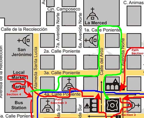
We could have taken a guided tour of the city, but none of us really likes that sort of thing, so we will just be walking through town on our own, carrying our little maps with us. To help you follow along on our walks, I have made a digital copy of the guide map to the city, and have put it in a scrollable window for you to look at. I have marked the route that our bus took to enter town and drop us off and the route that it took back out of the city with a blue line. The path we followed through the city will be marked in red (as near as I can remember it three months after the fact. I will also break up the walk into sections, and each section will have its own little path and arrow.
There is one complication. I got separated from the other guys somewhere in the local market when I went back to purchase a wooden horse for my sister. While I marked my own path after that point until we met up again at Plaza Mayor, I can't know what path the other four guys took. We did stop at some of the same churches and other locations, so I can group those pictures together, but that's the best I can do. When there is a case where the other guys saw something interesting that I missed, I'll just include it in a section just before we met up again.
The map below will probably load for you with the scroll bar (horizontal scroll) all the way at the left and the elevator bar (vertical scroll bar) all the way at the top. Thus, the map will load positioned in the extreme northwest corner. As I said earlier, the bus entered from the southwest, so to begin, you might slide the elevator bar all the way to the bottom so you can see the blue bus route coming in. Follow it to its end and that is where the first path section will begin.
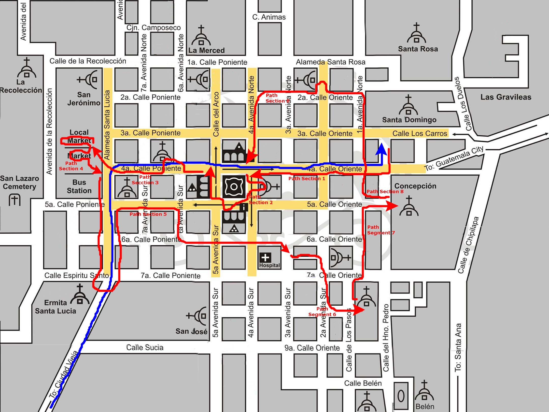 |
Path Section 1: From the Dropoff Point to Plaza Mayor
|
As we walked down the street, I looked inside a number of different shops and we went inside an art gallery. Click on the thumbnails below to see some of these:
|
|
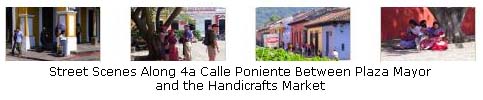
Fred also took a number of pictures of the street scene as we walked down 4th Street towards Plaza Mayor, and if you click on the thumbnails below, you can see some of them:

|
After about four blocks of interesting walking, we came out into the northeast corner of Plaza Mayor.
Path Section 2: Walking Around Plaza Mayor
|
Entering Plaza Mayor |
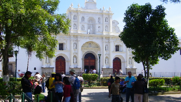
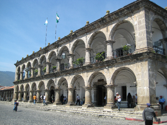
Plaza Mayor is the physical center of the city. In 1543, Italian architect Antonelli designed the city's checkerboard layout around Plaza Mayor. In the middle of the plaza, and still working, is La Fuente de las Sirenas (" Mermaid Fountain"), built in 1739 by Diego Porres. For another view, here is Fred and the Mermaid Fountain. We took a couple of other good pictures using the fountain as a backdrop; you can see one with Fred and our group here (in the picture, left to right, are Fred, Gary, Bud, Greg, Paul and Chet) and Fred's picture of me and the group here. And just before we walked across the street to the east to look at the Cathedral of Santiago, I turned to look north towards City Hall and took a picture of Fred.
Fred also took a number of excellent pictures in and around the interior of the Plaza Mayor, including an interesting closeup of one of the mermaids. Click on the thumbnail images below to have a look at them:

|
|
Before we left the plaza, Fred stood near the fountain and made a movie looking all around the plaze. You can see just about everything (and I mean everything in it. |
|
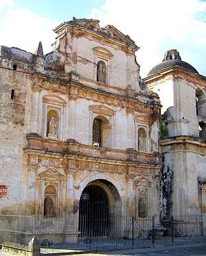
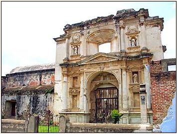
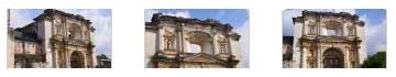
| Cathedral of Santiago/Church of San Jose |
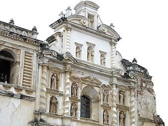
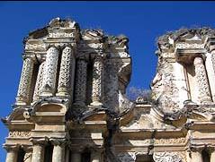
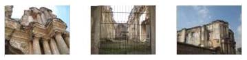
The construction of the building started in 1542 with a very simple design, but by 1680 this church became extraordinarily big, under the mastership of Joseph de Porres. It was initially designed and divided into a main church sanctuary, 5 naves, 68 smaller chambers and 15 other chapels including the Royal Chapel. A total of 73 windows illuminated its interior and the access was possible through 6 gates. In the backside there is a very big belfry and therefore the 3th avenue was named Calle de las Campanas ("street of the bells"). After its rebuilding in the late 17th century, it was a maze of naves, chapels, domes, arches and belfries, lit by dozens of strategically placed windows. The walls and niches were decorated with paintings and statues of saints. One of the naves contains an odd decoration- Christ in a transparent tomb, a tomb much like the one Alexander the Great was though to have used. I'd not seen anything like this before.
The cathedral's facade is a composite of elements from the wreckage of the colonial building. Behind the facade is the main chapel- now called the Church of San Jose. The rest is a jumble of ruined arches, broken columns, crumbling walls and rubble. According to some authors, in this chambers and crypts rest the remains of Don Pedro de Alvarado, Dona Leonor de Alvarado, Don Pedro de Portocarrero, Don Bernal Diaz del Castillo and the Bishop Francisco Marroquin. The facade shows today the sculptures of Sr. James, The Virgin Mary, the Eternal Father, the twelve Apostles and a Priest.
|
I mentioned earlier that I'd made a good movie of Plaza Mayor from the top of the church steps; you can watch it here. |
When we left the building and walked to the southeast corner of Plaza Mayor, I turned back to get a different view of the Church of San Jose.
|
From the Palace, we walked across the southwest corner of the plaza, past a fruit vendor and up onto the arched walkway that runs along the west side of the plaza. Here, we walked north through the crowds of people patronizing the restaurants and cafes that lined the outside promenade until we came to the corner of 4th Avenue and Calle del Arco. Looking up the street ahead of us (Calle del Arco), we could see the Church of La Merced four blocks ahead of us. We thought we might visit it later.
|
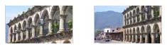
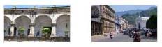
If you want to see some other interesting views of the City Hall, including some close-ups of the stonework, you can click on the thumbnail images below:
|
|
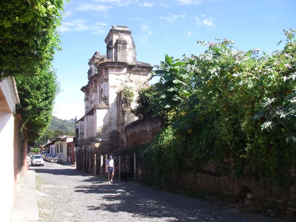
Path Section 3: West on 4th Avenue to The Market
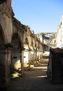
Diego de Porres designed this church, whose ruins, so old that vegetation grows high on them, survive as a reminder of days gone by. This church originated from a petition of the Jesuits to build a school. It was partially founded in 1561, upon the issue of the permit. In 1580 the real work began and, in 1582, the school was inaugurated. The temple was finished in 1626. We were able to get right up to the side of the ruin to see how the walls were constructed.
An earthquake destroyed the building, which was rebuilt in 1689. The Jesuits were expelled from the country in 1767, the year when the buildings that were finally destroyed by the earthquake of 1773 started being abandoned. They were turned into a handicrafts market in this century. The most recent earthquake of 1976 also damaged them. Today, you can see one part of the temple, in ruins, and another part that has been restored by the Spanish Cooperation Agency, where it set up its offices. The beautiful facade came to light again when the handicrafts market was moved to the central market to which we were headed.
Fred took some very good pictures of the design elements of the facade and of the church, using his zoom lens, and they are very interesting. You can click on the thumbnail images below to have a look at them:
|
|
I also walked into another establishment because I could see that it also had an internal courtyard with quite nice fountain. I've of course seen other outlets of this establishment before, as have you, but never one designed anything like this. You should definitely watch the movie I made.
|
As I said above, I came into this restaurant to see the courtyard and fountain, but didn't realize that it was part of the restaurant itself. Where am I? Watch the movie to find out. |
Below I am going to repeat the scrollable Antigua map so you can follow us on the next few sections of our walk around the city:
|
|
Path Section 4: In the Central Market

|
South of what I think I remember were three long double-sided aisles of movable vendor stalls was a large rectangular permanent building with two interior courtyards- which would probably look like a giant rectangular "8" if there had been a good aerial view available. Here, the vendors had small alcoves that were more permanent; these were arranged along outside covered walkways that went around the outside of the building and also around the inner courtyards. The goods were also more intricate (and expensive). In the two middle areas of the figure "8" were open courtyards. Each one had a fountain in the center. The two fountains were essentially duplicates of each other, although one of them had some roses that Fred thought were pretty.
|
|
We wandered around here for quite some time so Paul could find just the right souvenirs for some of his nieces and nephews. The rest of us were just browsing. There was lots of kind of interesting stuff, but the last thing I needed were any knicknacks to gather dust. (There were oodles of these little owl-looking carvings that we'd seen all over town, though. I never asked what they were, but they were certainly ubiquitous. I thought I should get one, so I purchased a very small one for a dollar. They are the ones that appeared in an earlier picture that you can see again here.)
At one point, I saw a wooden carved horse that I thought my sister would like, but I hadn't brought enough cash with me to even pay the price the store owner finally offered. So we moved on to a different part of the building. While Paul was negotiating for his own stuff, I thought I would go back and see if the store owner would sell the horse for the cash I had- only a dollar less than he was asking. I did, and he did, so I bought it. When I returned to where I'd left everyone else, they'd disappeared. I looked all around the market for them, but they were nowhere to be found. This is where our paths around the city necessarily diverged, then. I have no idea what path they followed, so I won't attempt to make notations on the scrollable map for them. The remainder of what you'll see on the map is the path I followed as I explored the southern part of town on my own. I did meet up with them at the appointed pickup time back at Plaza Mayor. After you've followed me around, I have a section where I can include Fred's pictures of the places he got to and I didn't.
My Path Section 5: Market to the Church of Hospital San Pedro
 Monument to Rafael Land�var |
|
The monument was closed, but I did make a movie of the activity on the Alameda in front of it. |
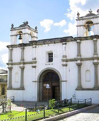 Church of Saint Lucia |
This church was built about 1542 and it was one of the first churches that invited natives and new inhabitants to participate in the liturgy. The facade was very sober, unlike those of other churches, which were profusely adorned. It has twin bell towers and the atrium is now a small plaza covered with scant vegetation.
The earthquakes of 1717 and 1773 damaged St. Lucia just as the rest of the churches of the city. The latter tremor caused the worst structural damages. Today the church houses several images, including the Virgin of Candelaria, which is taken out in procession on the first Sunday of February, before February 2, the day of her feast. It is also the abode of the images of the Virgin of Conception and Jesus of Nazareth, among others. I found out later that very few people come to visit this church because it is not located in a "convenient" area.
Back out on the Alameda, I was struck by the profusion of brightly‑painted local buses- each one seemingly more brilliant than the last. I walked back up the other side of the Alameda to the 5th street corner and then turned east and headed down the quiet 5th street West.
I saw quite a few interesting places as I walked along. I went inside one passageway, and found myself looking at somebody's kitchen! There was a little interior garden that had drawn me in originally, and there were chickens running about. It was odd that there was no door at the street, but it was obviously not a public space, so I turned and left right away. A little further down the street I came to The Black Cat Inn which turned out to be a highly-recommended upscale hostel- with free Wi-Fi!
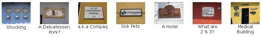
As I was walking along, I was just looking at everything, and taking pictures of anything I found funny or unusual. Quite a few of my pictures from this part of my walk were of signs- just your typical signs telling what was inside the building. If you'll click on the thumbnail images below, you can have a look at some of these humorous or interesting pictures:
|
 Church of St. Augustine |
Each ruin or temple of Antigua Guatemala causes a different impression upon the visitor. Some have minute details and finishes, while others encourage meditation. Saint Augustine fosters peace, perhaps because of its surroundings. It is located on this quiet street not usually visited by tourists. The chronicles of yore state that the church was the abode of very valuable paintings and beautiful altars. It was dedicated to Saint Augustine. At first, authorization for the construction was denied because the neighborhood was very poor. This Renaissance-style church was completed in 1657. It has not been open to the public in many years. First, the earthquakes of 1717, 1751, and 1773 damaged it severely. Then, it was used as a stables until the roof caved in. I can only suppose that money is hard to come by to keep ancient buildings like these in good repair.
Continuing east, when I crossed 5th Avenue South I could look north up the street to Plaza Mayor, and see the corner of the Governor-General's Palace. I was actually a bit hungry, and would have stopped in at a local restaurant I passed. Everything on their menu sounded good, and at about eight quetzals to the dollar, incredibly cheap. Just past the restaurant, and perhaps part of it, was another very tranquil interior courtyard.
 Hospital San Pedro |
An ill-advised maintenance project painted the temple and the hospital. It is adequately illuminated during the nights, which has turned it into an irresistible site for photographers. The fa�ade of the church is traditional and elevated; the sides are lower and do not have bell towers as the other churches of the city. The details are evidently Baroque. On the side, on 3d Avenue South, there is a sober wood door. The columns at the entrance, as well as those above, have circular details in the Salomon style.
The two buildings were built in 1654 and are one of several works of Jos� de Porres. Originally, the purpose of the hospital part of the complex was to provide medical aid to the members of the Ecclesiastic community. Only nine years after it was built, it started to take care of the public. Its name is linked to Saint Brother Peter, who, according to church records, was instrumental in getting the hospital part of the complex built. He apparently lived long enough to see his dream come true.
As with so many Antiguan buildings, earthquakes over the years damaged the buildings severely but, unlike some other sin the city, restoration efforts have allowed both the church and the hospital to continue operating. Each Sunday, mass is held here.
Below I am going to repeat the scrollable Antigua map so you can follow us on the next few sections of our walk around the city:
|
|
My Path Section 6: Hospital to the Church of San Francisco
 Union Water Tank |
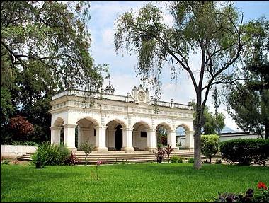
The most famous of these communal laundries these days is the Union Water Tank, where some people still go to wash and it seems as if time never went by. The Tank was inaugurated in 1853 by chief magistrate Jos� Mar�a Palomo. It consists of a large pool and a long open but covered arcade with a long line of stone washbasins. It was not well-constructed at the time; it was rebuilt in 1979 and it is preserved until this day. Its arches are of Neoclassic style and the original name was Plaza de la Union, but in 1925 the Unionist Congress of Central America took place and the name was changed to Union Park and Tank.
The Tank only occupies the end of the block- about a sixth of the area. The rest of the block is devoted to a park. A statue of Jesus on the cross has been placed at the center of the park, this was a gift from Spain. This park is the object of multiple visits by tourists, who usually take pictures on the benches or the colorful borders of the tank.
 Convent Santa Clara |
The Sisters of the Order of Saint Claire that had arrived from Puebla, Mexico, founded this enormous convent in 1699. It started out as a small venture, with a church and a few houses that, in time, became the huge complex we can still see today. On January 14, 1700, 5 nuns and a novice became the first inhabitants of the convent. In 1703, formal construction of the complex began and was finalized two years later. Many historians have stated that the convent�s shingled roof caved in during the earthquake of 1717, when the building became so damaged that the nuns had to seek shelter in Comalapa until the roof was repaired.
The reconstruction spanned over 26 years. The President of the Audience, Antonio Echeverr�a Suvisa, who died in 1733 and did not see the fruits of his funds, financed the effort. There are no traces remaining of the original building. The new facilities were inaugurated and consecrated on August 11, 1734. In 1773, another earthquake destroyed the building. The few elements that remained standing were ruined by another earthquake in 1874. What we see today is the product of the efforts of the complex�s management.
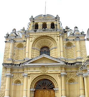
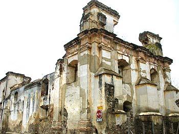
 Cathedral San Francisco |
The fa�ade of the church is ornamented with Salomon style columns; the left tower is in pristine condition; the right one shows the damages caused by earthquakes and time. Non-relenting earth movements caused serious damages and destroyed one part of the building in 1565, 23 years after it had been built. Another earthquake later destroyed the reconstructed building. The church was restored once again and still stands: its faithful gather at mass every Sunday.
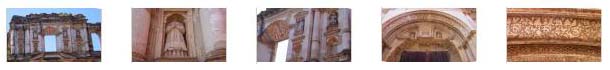
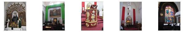
The ruins of the former buildings can still be visited next door. The new church has an old and deteriorated appearance and many believe that this does not do justice to the reconstruction efforts. This was one church that I decided to go into, and I spent a good deal of time wandering around. The main chapel was quite pretty; it certainly shows the care that the city and the parishioners have expended. If you'll click on the thumbnails below, you can see some of the interior ornamentation in the chapel:
|
This temple receives many visitors because the remains of Saint Brother Peter of Bethancourt rest inside. The hallway leading to his burial site is flanked by lit candles and the prayers of the faithful can be heard from outside.
|
This was an exceptionally nice church inside, and I made a movie with very quiet narration as I panned around the chapel. |
Outside the chapel there was a very pretty garden with a statue of Saint Francis in the middle of it. Off to one side, there was also an interesting fountain with a painted background, apparently celebrating the 800th anniversary of the founding of the Franciscan Order. The church and garden and the ruins as well are all situated inside a walled compound, and the open areas are covered with cobblestones. Many vendors of typical candy and souvenirs set up shop inside these walls.
My Path Section 7: Church of San Francisco to the ruins of Conception
Once again, I encountered a number of interesting signs that I thought merited pictures, and if you will click on the thumbnails below you can see some of them:

|
 Ruins of Conception |
In 1563, Bishop Francisco Marroqu�n donated some land to build a convent, but fourteen years went by before a group of religious authorities requested, along with their Mexican counterparts, the arrival of several sisters of the order of the Immaculate Conception to begin the convent. The work of the four initial nuns became evident one year after, when they recruited a new novice who would become the first Guatemalan nun.
This convent was, in fact, the first one for women in Guatemala. The chapel was inaugurated in 1729, 166 years after Bishop Marroquin�s initial plans. Historians of the time state that more novices sought enrollment in the convent. At one time, there were more than 100 devoted sisters living in the facilities.
Today we can see the ruins of the original convent, which was destroyed by earthquakes. The convent was abandoned in 1774.
My Path Section 8: To the Ruins of El Carmen and Back to Plaza Mayor
 Ruins of El Carmen |
This church was founded in honor of Our Lady of El Carmen. The required permits were issued in 1638, and construction was completed a couple of years after that. The original church did not have the minute details of the second building, erected after the earthquake of 1717. That second building was finished in 1728 but succumbed to the earthquakes of 1773. The stucco fa�ade, however, survives today. The fa�ade, just as those of other churches, is the home of birds that add life to its impressive presence during the day. We were not here to see it, but during the night the architecture is also prominent, because its frontispiece and columns are artistically illuminated.
If you will click on the thumbnail images below, you can see three more views of these ruins:
|
It was about thirty minutes until pick-up time at Plaza Mayor, so I walked back down there and had no trouble finding the other guys.
The Other Guys: Where They Went and What They Saw
|
I can be sure that they stopped at two churches- The Convent and Church of La Merced, and the ruins of the Church of Saint Theresa, neither of which I, myself, saw. So we'll look at some of the pictures that Fred took there. Fred also took a number of interesting pictures of various typical Antiguan and Guatemalan street scenes, and I'd like to include some of those here, too, since he has such a good eye for a lot of things.
Let's begin with their stop at the Church and Convent of La Merced.
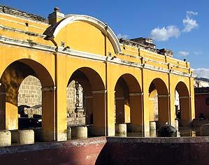
This church is one of the landmarks of the Colonial City. National and foreign photographers have visited its atrium to capture the details of its Baroque stucco facade; there are so many minute adornments over and around the entrance that it is almost impossible to do them justice in just a few photographs. Juan de Chaves, to whom many documents refer to as �Juan de Dios�, did the finishing touches of the building and the altar. Inside the convent, in the main courtyard, is one of the largest classic fountains of the city. Wide halls and beautiful arches surround the courtyard.
The Church of La Merced originated with the efforts of the friars of Order of the Mercies, one of the oldest in the American continent. This order arrived in America in the first vessels that traveled from Spain, and by 1541, had aquired the land on which the church now sits. Construction of the church began in 1583, and was completed in about three years. Earthquakes destroyed the building once; it was rebuilt in 1767 as we see it today.
The convent was not so lucky: it was reduced to ruins regardless of its very thick walls. The place was later used as a quarry. There are two fountains around the church, one in front of the cross and the other one in the plaza. Coming up from Plaza Mayor, the church can be seen up the street through the Arch of Saint Catherine.
Click on the thumbnail images below and look at some more of Fred's pictures of La Merced:
|
From La Merced, they must have come south on 4th Street for they passed right in front of the ruins of the Church of Saint Therese.
 Ruins of the church of Saint Therese |
Click on the thumbnail images below to see a few views that Fred took of this ruined church:
|

|
|
At the left are ten thumbnail images for the best of his pictures. Click on as many of them as you wish to view.
Together Again in Plaza Mayor
I succumbed to buying a couple of wooden pan pipes from a kid. I thought I was doing pretty well to get the price down from $10 each, which is was earlier today, to 2 for $6 which it ended up being this afternoon. Fred took more pictures as we were waiting for the replacement bus to arrive, and if you will click on the thumbnails below, you can have a look at these pictures of the activity this afternoon in Plaza Mayor:

|
Returning from Antigua to the Oosterdam
When the bus arrived, we all piled off and made our way back to the ship. Fred and I misplaced the other three guys, and went on towards the ship to get in line to reboard. Today, all the tours had come back at basically the same time, so the line to board the ship was quite long. We'd been waiting in it for five minutes or so when I realized that I'd left my cap on the bus, so I told Fred I would meet him in the buffet for a snack as soon as I went back to retrieve it. When I got back to the parking area, the buses had been moved, but I eventually found ours. No cap. I looked thoroughly but couldn't find it, so I went back and got on board. Later that evening I was pleasantly surprised to find that Greg had noticed it hanging on the seatback and had picked it up and brought it back with him. Thanks, Greg!
Leaving Puerto Quetzal/Evening Activities
Here's what the Daily Program had to say about Elliot Maxx:
| "Although Elliot Maxx may not be a household name, his subtle and intelligent comedic style has earned him the reputation as one of the most gifted and original talents working today." |
Well, he might not be the most gifted entertainer working today, but this Peter Graves look‑a‑like was certainly entertaining enough. With just a guitar and a bit of singing and a lot of banter, it filled up the hour quite nicely.
|
Fred made this movie of Elliot Maxx doing a short, funny song. |
I made this movie of some of the joking banter of Elliot Maxx. |
Fred and I also went up to The Crow's Nest to listen to Taylor Brown for a while.
We were up kind of late, but since our shore excursion tomorrow doesn't leave the ship until eleven, it didn't matter.
Antigua was really neat, and even though today's excursion consisted solely of a bus ride, it was a really interesting day.
You can use the links below to continue to the album page for different day.
|
November 14, 2009: Puerto Chiapas, Mexico |
|
November 12, 2009: A Sea Day |
|
Return to the Index for Our Panama Canal Cruise |