|
October 19, 2010: Meteor Crater, AZ |
|
October 17, 2010: Hiking Around Sedona |
|
Return to the Index for our Western Trip |
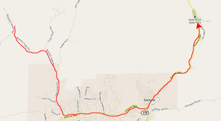
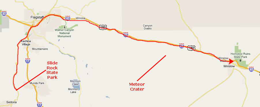
Today we are going to be doing some more hiking in the Sedona area, and then we will head out of town towards Flagstaff, stopping at Slide Rock State Park on the way. From Flagstaff, we will head east to position ourselves for tomorrow's visit to Meteor Crater.
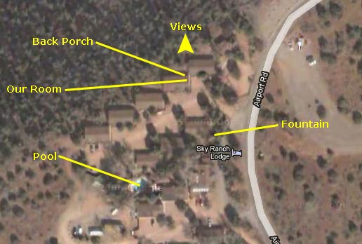
At Sky Ranch Lodge
|
|
|
We got ready to leave the lodge and while I was checking us out, Fred wandered about the grounds up near the office taking a couple of additional pictures. One was of a pretty fountain near the office and the other was of the swimming pool (which was heated, as it turned out, and which we probably should have taken advantage of last night). All checked out, we were off to our first hike of the day- the Arch at Fay Canyon.
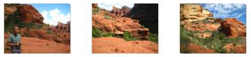
The Natural Arch at Fay Canyon
|
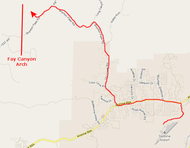
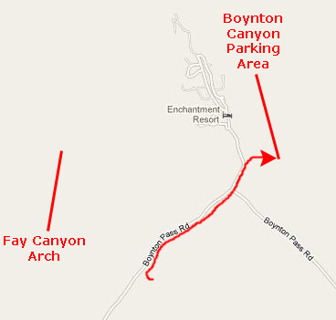
So we resolved that today we would return to Fay Canyon and follow the directions we got off the Internet to get up to the arch. We once again headed out Highway 89A to Dry Creek Road, and took that north to Boynton Pass Road. We followed this through a couple of intersections until we were back at the parking area for Fay Canyon. This parking area was just up the road from the parking area for the Doe Mountain hike that we took day before yesterday, and from the Fay Canyon parking area you can see Doe Mountain.
|
|
Having made my movie, we headed up the Fay Canyon Trail again, new directions in hand.
|
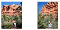
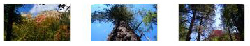
As you can see from the picture at right, as soon as we came out from the lowlands and the trees, we could see the arch up ahead of us. About halfway up the side of the mountain, Fred stopped to set up the tripod and take an excellent shot of us with the natural stone arch in the background, and you can see that picture here. While he was taking down the tripod, I clambered up ahead of him towards the arch, stopping to look back and get a picture of Fred coming up the hillside.
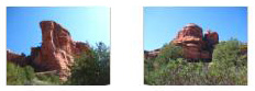
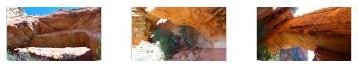
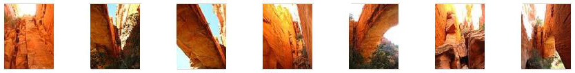
And then we arrived at the Fay Canyon Arch. We went underneath the arch and then behind it where we could look out underneath it to the hillside beyond. Click on the thumbnails below to see some of the best of Fred's pictures of the Fay Canyon Arch:

|
|
|
From the vantage point of my movie, I, too, could look under the arch to the valley beyond. Very, very beautiful. I also took a couple of pictures of Fred here at the arch. The first one shows Fred underneath the arch with the mountainside beyond him; I took it from the very back of the crevice formed when the arch separated from the wall of the cliff. You can see a picture of Fred at the back of this crevice if you click here.
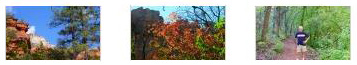
As Fred did, I took a great many pictures of the Fay Canyon Arch, trying to capture the size of it, the beauty of it and the color of it. You can see the best of the pictures I took if you click on the thumbnails below:
|
We spent a good deal of time here at the arch. Just before we left, we walked down to the rightmost end of the sheltered area under it and found that someone (certainly not ancient cliff dwellers) had tried to mimic the Palatki Ruins by constructing their own cliff dwelling. Just to prove they could do it, I guess. When we were done at the arch, we went back down the hillside, passing some more hikers coming up (we'd had the arch all to ourselves during our visit), and back down the Fay Canyon Trail to the RAV4. And then it was off to the longest hike of our western trip- the hike to Boynton Canyon.
The Boynton Canyon Hike
|
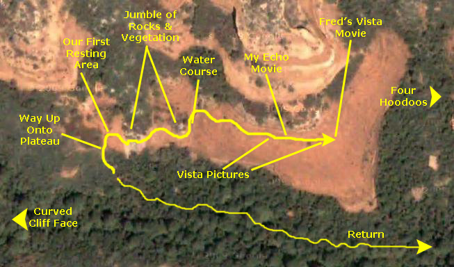
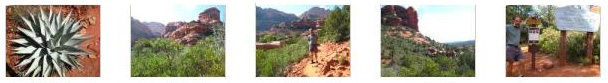
Fred had investigated the hike before we left Dallas. It was supposed to be a 4.5-mile roundtrip hike; at least that is what Fred thought he'd read. Below is a very high level aerial overview of our hike:
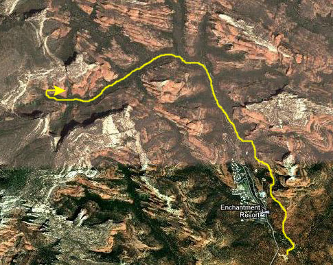
The hike began at the parking area and then went north/northwest along the east side of the Enchantment Resort. Then it continued in the same direction, eventually turning to the northwest and then to the west to go up Boynton Canyon. We did not know it at the time, but at the end of the hike there would be views that made it all worthwhile.
The other thing we didn't know until we were hours into the hike was that it was 4.5 miles one-way, not roundtrip. We'd begun to wonder about that after we'd hiked for more than an hour through open high desert and then through dense forest. But by then we'd invested so much into the hike that we wanted to see it to its conclusion. We did pass a couple of hiking groups on their way back who assured us that there was an eventual end to the interminable walking.
But the hike, although it started out hot and dry, turned warm and shady for most of its course, and so it was a pleasant, if long and tiring, walk.
I'm going to break up the pictures we took on this hike into sections; it was a long hike and we took lots and lots of pictures. There will be three sections. The first will cover our walk from the parking area alongside the resort until the trail disappeared into the forest. The second section will cover our long walk through the forested area of Boynton Canyon. The third and final section will contain the pictures we took from the viewpoints at the far end of the hike.
Tracing Our Hiking Route
To begin, you should make sure that the vertical scroll bar is all the way to the bottom and that the horizontal scroll bar is all the way to the right. This will position you at our starting point in the parking area. As we go along, you can use the vertical scroll bar as we go north/northwest, and the horizontal scroll bar as we turn west (or a combination of the two as necessary). I hope that following us along in this manner and seeing some of the features we photographed as they appear from the air will add to your enjoyment of the pictures we took. Here, then, is the scrollable aerial view of our hike:
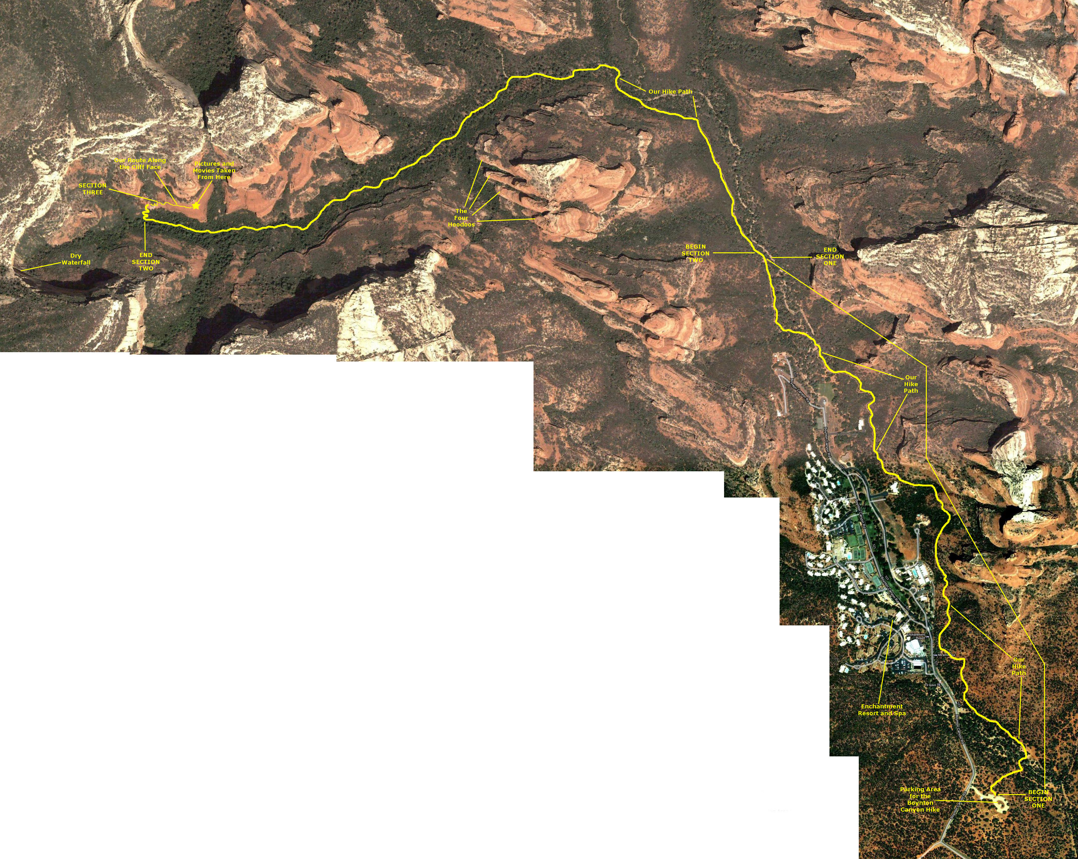 |
Section 1: Open Country Alongside the Enchantment Resort
|
|
The first section of the trail took us alongside the Enchantment Resort. The whole thing was fenced in, mostly to keep hikers and people not staying at the resort from tramping across the resort property, I imagine. There were some places where the trail came right alongside the fence, but mostly it stayed a hundred feet or so from the resort grounds- which were on our left as we walked north.
|
Fred took some great pictures of the valley we were hiking through, including many of the resort buildings. Click on the thumbnails below to have a look at these pictures:
|
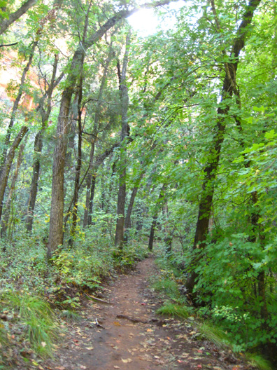
As I said, after about a mile and a half we crossed the arbitrary boundary between the first and second sections of the hike, with the second section being forested.
Section 2: Through the Forest
|
For a while, we followed a dry streambed, but most of the time we were just zig-zagging through the forest. The path seemed interminable; the forest seemed to go on forever. Now I can see that we were following a dogleg canyon, but it was impossible to know that while we were on the trail.
Fred took some really good pictures along this part of the trail, and you can have a look at them if you click on the thumbnails below:
|
Eventually, after what we later learned was about four and a half miles, the trail started ascending steeply up a rocky hillside- still in the forest. At the top of this ascent, we came out above the forest and to the end of the trail. At first we thought that we'd come all this way just for a nice hike in the woods, but then we noticed that the sign at the end of the trail was there to indicate that you shouldn't go any further in the canyon itself (indeed, the canyon ended another few hundred feet ahead at a sheer curved cliff). Instead, there was an extension of the trail that led up onto a relatively bare rock formation, and it would be here that we'd find the views that made the whole hike worthwhile. You'll see them in the next section.
Section 3: Views From the End of Boynton Canyon
|
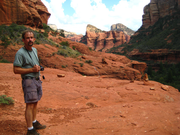
From this vantage point, we could also get a beautiful view of the cliffs south of us and, if we stood up, we could see past a jumble of rocks and bushes towards a continuation of the sloping red rocks we were sitting on and beyond that a view east down Boynton Canyon.
It was a pleasure to sit down for a moment and savor the reward for our four miles of hiking.
|
|
We had invested so much time and effort getting here that I wanted to explore some. I could see that if you went around the end of the rocks and bushes just to our east, the views might probably be better down the valley, so I left Fred for a moment and clambered around that area to a more open area on the other side. There was no danger here; the cliff face was only gently sloping down to its eventual drop-off to the forested area below, and there was plenty of flat space to walk on without getting anywhere near the edge above the forest.
Fred joined me pretty quickly and we found ourselves on a broad open area of red rock where it was easy and totally safe to stand and take pictures. Fred took some pictures of the area around us here at the end of Boynton Canyon, and I took a picture of Fred.
|
|
One interesting feature of this area was the stain left behind by many years of intermittent water flow over this part of the cliff face. The watercourse began higher up (where I am sitting in the picture you can see here), and then flows in a wavy course down the rock until its eventual fall over the cliff down into the forest. Water from sources such as this one and the larger waterfall at the end of Boynton Canyon is what sometimes fills the dry streambed we hiked along coming up. Once we got to the watercourse, we could see that it was entirely possible to go much further around and along the rock face. We just had to walk up to the top of the watercourse and then clamber over some more rocks and through some more low vegetation to a much broader, much longer stretch of red rock which, almost immediately, offered spectacular views all around.
|
|
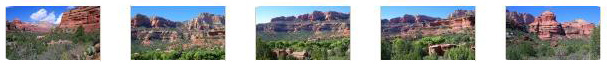
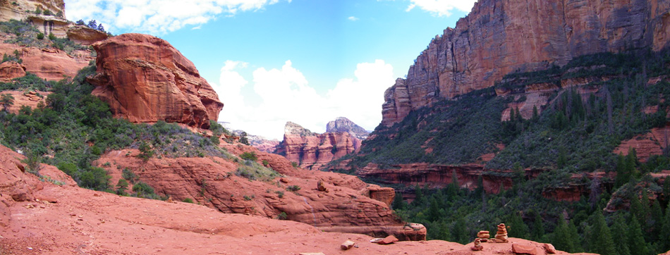
This was an amazing area, and we reveled in the beauty of the landscape in every direction. One of the first things Fred did was to stitch together a couple of widescreen pictures into a panorama looking back the way we'd come, and you can see the result below:
 |
All of the views were simply amazing; they would have made even a much longer hike totally worthwhile.
|
When we got out to the end of the cliff area where we'd been walking, I took a picture of Fred with the beautiful red rock cliffs in the background. You can have a look at that picture here.
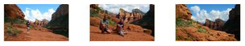
Below are six of the best of all the pictures that we took here- first three of Fred's and then three of mine. Click on the thumbnails to have a look at them:
|
|
Fred doesn't take many movies, but when he does they are really, really good. So by all means watch this movie he made from the furthest point along our hike and experience the grandeur of Boynton Canyon. |
We noticed that there was an echo up here in the canyon, and if you'll watch this movie you can hear it too. |
The Return from Boynton Canyon

|
|
Such an excellent hike, and a great way to cap off our visit to Sedona. But now, in mid-afternoon, it was time to head out of town and on to our next stop- Slide Rock State Park.
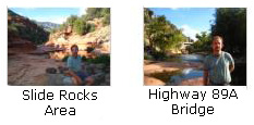
Slide Rock State Park
|
When we got back from the Boynton Canyon hike, we ate a snack and drank a lot, and then got in the RAV4 to return along Boynton Pass Road and Dry Creek Road to Highway 89A. Then we headed east and, for the last time, went through downtown Sedona and then on up 89A to the northeast. The distance to Slide Rock from Boynton Canyon was about twenty miles- a very scenic drive in the sunlit afternoon.
Slide Rock State Park is located in Oak Creek Canyon in north central Arizona, seven miles north of Sedona. Slide Rock State Park attracted almost a third of a million visitors last year and is one of the most visited tourist attractions in Arizona.
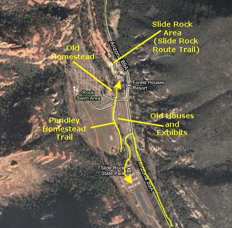
When we got to the State Park, we were both thirsty again, so when we parked in the large parking area, we took some stuff to a nearby picnic table. After that, we collected our cameras and walked north through the park. On the way to the actual slide rocks, there were a number of exhibits and some old buildings as well. Near the slide rocks, there was actually an old homestead.
We spent most of our time down at the slide rocks themselves, watching folks slide on their butts down the smooth rock channels. But more about that in a minute. Slide Rock State Park of course takes its name from this natural water slide, formed by the slippery bed of Oak Creek. The park is located on Coconino National Forest land and is co-managed by the Arizona State Parks agency and the U.S. Forest Service. Tall red rock formations that are typical of the region also surround the park, which contains a 43-acre working apple farm.
|
The Homestead Trail
The park was purchased by the Arizona State Parks from the Arizona Parklands Foundation on July 10, 1985, and dedicated as Slide Rock State Park in October 1987. The Pendley Homestead Historic District was accepted onto the National Register of Historic Places on December 23, 1991. The apple farm is one of the few homesteads still preserved in Oak Creek Canyon.
The original Pendley House was demolished in 1927 to make way for a larger residence. This new bungalow style house of native red sandstone remains today. Running water was brought into the house in 1927, commercial electricity in 1948 and telephone during the 1950s.
Beginning in 1912, several orchards were planted at the homestead. Some of the old equipment from the early period of the orchards is on display along the trail; we saw an old tractor, some smudge pots, an old water wheel and numerous other old pieces of farming equipment. The crops were harvested, boxed in the packing shed and sold wholesale to markets as far away as Los Angeles. Many varieties of apples were grown, including Arkansas Black, Red Delicious, Golden Delicious, Grime's Golden, Wolf River, Jonathan, York Imperial, Rome Beauty, Winesap, Crab Apple and Stayman Winesap.
At the Highway 89A Bridge
|
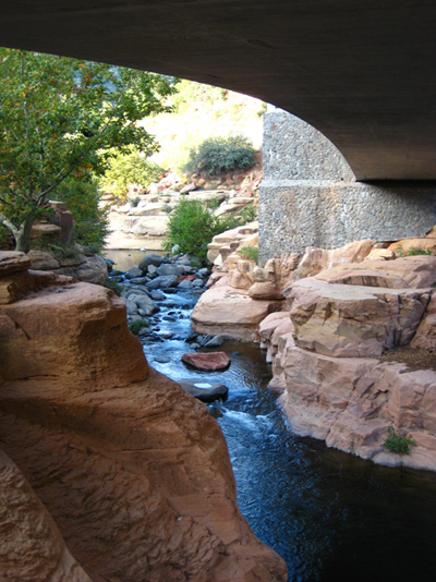
The first thing I did when I got down into the canyon was to walk right over to Oak Creek, which at this point was some twenty feet below me in a crevasse. The creek was flowing from my left which is where Fred went when we got down to the bottom of the stairs. He is waiting for me a ways upstream. I'd join him in a couple of minutes, but first I wanted to explore Oak Creek as it flows under the Highway 89A bridge. I went ahead along the rock ledges to a point directly underneath the bridge.
I continued along the rocky ledge above Oak Creek until I reached a point just on the other side of the bridge, where I could look back at Oak Creek flowing through its little canyon.
Then I headed back to join Fred.
|
On my way back upstream and underneath the Highway 89A bridge to rejoin Fred, I stopped to make a movie of this end of the creek as it flows underneath the highway bridge. |
I walked out from underneath the bridge to take another movie continuing the last one and showing Oak Creek as it flows out of the slide rock area and towards the bridge. There are numerous pretty little waterfalls in this area of Oak Creek as it flows towards the highway bridge. |
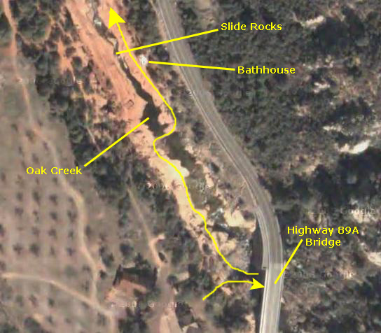
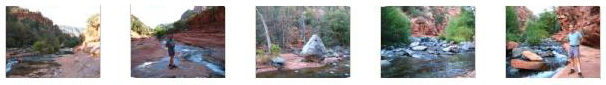
The Slide Rock Route
|
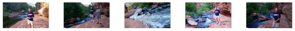
I also took a couple of pictures of Fred here, one looking back at the highway bridge and one looking upstream towards the slide rock area. You can have a look at these pictures by clicking on the thumbnails below:
|
Between the highway bridge and the area adjacent to the bathhouse (where you can see Fred standing here), Oak Creek flows through a rocky channel that is wide enough to allow the water to flow slowly and whose lining rocks are fairly rough. This area is also deeper, so there isn't any good sliding to be had here. But just north of the bathhouse, the rock underlying the creek was apparently much harder, and so it hasn't been eroded very deeply, but it has been worn smooth by the creek over time. In this area, the water flows rapidly over shallow, slippery, flat rocks that allow one to get up some speed and slide along. There are pools every so often, but these are not very deep and sliders seem to go through them and into the next shallow section without losing much speed.
So sliders will begin at the top of the slide area get up some speed, and then slide the rest of the way down towards where the bathhouse is. That's where Fred was standing when he caught a young slider near the end of the run.
Movies are the only real way to get a feel for what the slide rocks are like, so I've chosen three of the many that Fred and I took to show you.
|
This movie will show you the general area around the slide rocks and describe the route that the sliders take through the shallow, slippery area of Oak Creek. |
There were two girls about to slide down the creekbed, so I positioned myself near and just above them so I could follow both of them through the course. You'll get a great idea of what sliding is like by watching them. |
|
This movie that Fred made follows a young boy as he slides through the slippery course. |
After we watched the sliders for a while, we continued walking up the rocky bottom of Oak Creek. There were broad rocks on both sides for a ways, but we could see that the east side, the side we were on, would allow us to go further upstream. We walked maybe 100 yards or so, until we were well away from the sliders and their noise. At the north end of our walk, there was a ledge we could sit or stand on and just listen to the sound of Oak Creek as it flowed past us. We took quite a few good pictures here, and you can have a look at some of them if you will click on the thumbnails below:
|
|
|
At the far end of our walk up Oak Creek, I made a movie of the surroundings, panning from the view north around to the view south to the slide rocks. |
Just after we passed the bathhouse again, I made one more movie of the slide rocks area. |
We'd finished our walk along the Slide Rock Route here in Slide Rocks State Park, so we turned and headed back down the Oak Creek streambed towards the stairs we'd come down. Slide Rocks State Park had been really interesting, and we both enjoyed the visit immensely. But it was late afternoon and the light was fading, so we thought we would go ahead and position ourselves for our first activity tomorrow- a visit to Meteor Crater National Monument.
The Drive to Winslow, Arizona
|
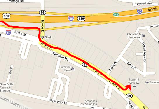
So that's what we did. We got back on Highway 89A north towards Flagstaff. It merged back into I-17 which we took to its intersection with I-40 east. Then we drove through some rain showers over to Winslow. We passed the exit for Meteor Crater, but it was of course already closed for today (and the weather wasn't great anyway).
|
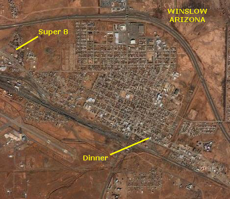
We spent some time downloading photos and then headed out for dinner.
|
We had a pretty decent meal and then headed back to the hotel.
You can use the links below to continue to the album page for different day.
|
October 19, 2010: Meteor Crater, AZ |
|
October 17, 2010: Hiking Around Sedona |
|
Return to the Index for our Western Trip |